Highest Capital Cities in the World
We picture capital cities at sea level — ports and river-mouths where trade gathered. A handful sit so high that visitors step off the plane and feel it: short of breath, light-headed, slowed down by air that holds a third less oxygen.
There’s a catch, though. Ask how high La Paz is and you get a different answer every time — sources spread across hundreds of metres, because each measures a different point. So we did it consistently: every capital sampled the same way, from Copernicus GLO-30, the European Space Agency’s 30-metre satellite model, at the city’s own coordinates.
Below is the ranking, a sortable table of all 194 capitals, and — because “highest capital” hides two genuine puzzles — an honest account of which city counts as a capital and why the published numbers never agree.
- 1La Paz12,365 ft (3,769 m)
- 2Quito9,383 ft (2,860 m)
- 3Bogotá8,478 ft (2,584 m)
- 4Addis Ababa7,884 ft (2,403 m)
- 5Asmara7,657 ft (2,334 m)
- 6Thimphu7,569 ft (2,307 m)
- 7Sanaa7,388 ft (2,252 m)
- 8Mexico City7,323 ft (2,232 m)
- 9Kabul5,909 ft (1,801 m)
- 10Gitega5,522 ft (1,683 m)
The highest capital cities
The top of the list is almost all Andes and highlands. La Paz (12,365 ft (3,769 m)) leads, followed by Quito (9,383 ft (2,860 m)) and Bogotá (8,478 ft (2,584 m)) — three national capitals strung along the northern Andes, each built on a high plateau or basin rather than the coast below.
East Africa supplies the next cluster: Addis Ababa (7,884 ft (2,403 m)) in the Ethiopian highlands, Asmara (7,657 ft (2,334 m)) in Eritrea, then Gitega and Nairobi in the Great Lakes highlands. Between them sits Thimphu, Bhutan’s Himalayan capital at 7,569 ft (2,307 m), and Mexico City at 7,323 ft (2,232 m). Only three capitals — La Paz, Quito and Bogotá — clear 8,202 ft (2,500 m).
Why are some capitals so high?
It looks backwards — why build your capital where the air is thin? — until you notice they cluster near the equator. In the tropics, low ground is hot and, historically, malarial; altitude is what makes the climate livable. Climb a kilometre or two and you trade jungle heat for what Quito and Bogotá residents call eternal spring: mild days, cool nights, all year.
That is why the pre-Columbian and colonial capitals of the Andes, and the old highland seats of Ethiopia, grew where they did — on high, temperate plateaus a short vertical distance from the tropical lowlands. The same equatorial-highland logic put Addis Ababa at 7,884 ft (2,403 m) and Asmara not far below. Away from the tropics the pull reverses — temperate-zone capitals sit low, on rivers and coasts.
Which city counts as the capital?
“Highest capital” has a hidden ambiguity: some countries have more than one capital, so the answer depends on which city you count. We rank by the seat of government — the city that actually runs the country — and note the split where it matters.
Two other countries split the role, and in both the seat of government is already the higher city, so the ranking is unaffected. South Africa has three: Pretoria (administrative, the one we rank), Cape Town (legislative) and Bloemfontein (judicial). Eswatini has Mbabane (administrative, ranked) and Lobamba (royal and legislative). In each case we take the administrative seat and note the others here.
What altitude does to a visitor
Air thins with height: at La Paz’s 12,365 ft (3,769 m) there is roughly a third less oxygen in every breath than at sea level. Arrive quickly from low ground and the body notices — the headache, breathlessness and sleeplessness of acute mountain sickness, which becomes common above about 8,202 ft (2,500 m). The top three capitals all sit above that line.
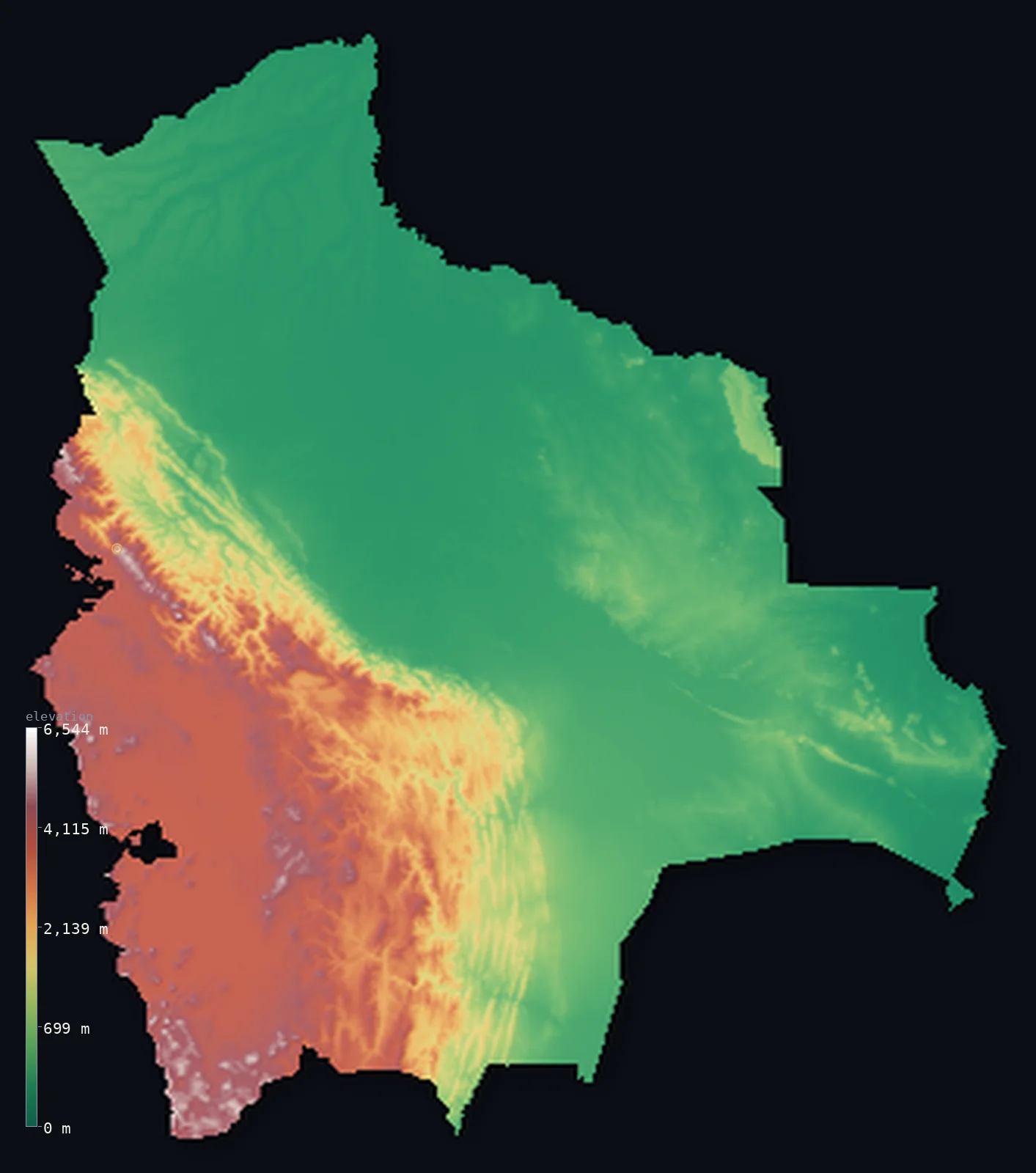
It shows up in sport, too: football played at La Paz’s altitude is hard enough on visiting teams that the fairness of high-altitude matches has been argued over at the sport’s governing level. For a traveller the standard advice is duller but sound — arrive slowly, rest the first day, go easy on exertion until the body adjusts. Our maps show the terrain these cities are stacked on; see Bolivia for the Altiplano that lifts La Paz so high.
Why sources disagree on the numbers
Look up La Paz’s elevation and you’ll find figures spread across roughly three hundred metres, from the high 3,600s to nearly 3,900. None is exactly wrong — they measure different points. La Paz pours down a canyon and up onto the Altiplano rim, so its “elevation” depends entirely on where you stand: the central valley, the airport up on the rim, or the sprawl of El Alto above it.
That inconsistency is the whole reason for this page. Every figure here is one measurement, made the same way for every capital: the median ground height in a small window at the city’s coordinates, read from the same satellite model. Our La Paz sample — the city centre — is 12,365 ft (3,769 m); the El Alto rim beside it runs some 200 m higher, which is where the loftier published numbers come from. The value isn’t that ours is the “true” one — it’s that all 194 are comparable.
The lowest-lying capitals
At the other end, a single capital sits below the sea: Baku, Azerbaijan, on the Caspian shore at 16 ft (5 m) below sea level — the Caspian itself lies well below the ocean (see countries below sea level). Just above it come the low island and delta capitals — Funafuti, Yaren and the Pacific atoll seats — all within a metre or two of the tide.
Between the extremes, most of the world’s capitals sit low: on rivers, estuaries and coasts, where people and trade have always concentrated. The high capitals are the exceptions, and — as the map shows — they are exceptions with a clear geography.
All 194 capitals, ranked
Sort by elevation, capital or country. Every elevation is our own GLO-30 sample at that capital’s coordinates; each country links to its full interactive 3D map.
| # | |||
|---|---|---|---|
| 1 | La Paz | Bolivia | 12,365 ft (3,769 m) |
| 2 | Quito | Ecuador | 9,383 ft (2,860 m) |
| 3 | Bogotá | Colombia | 8,478 ft (2,584 m) |
| 4 | Addis Ababa | Ethiopia | 7,884 ft (2,403 m) |
| 5 | Asmara | Eritrea | 7,657 ft (2,334 m) |
| 6 | Thimphu | Bhutan | 7,569 ft (2,307 m) |
| 7 | Sanaa | Yemen | 7,388 ft (2,252 m) |
| 8 | Mexico City | Mexico | 7,323 ft (2,232 m) |
| 9 | Kabul | Afghanistan | 5,909 ft (1,801 m) |
| 10 | Gitega | Burundi | 5,522 ft (1,683 m) |
| 11 | Nairobi | Kenya | 5,499 ft (1,676 m) |
| 12 | Windhoek | Namibia | 5,436 ft (1,657 m) |
| 13 | Maseru | Lesotho | 5,062 ft (1,543 m) |
| 14 | Kigali | Rwanda | 5,062 ft (1,543 m) |
| 15 | Guatemala City | Guatemala | 4,931 ft (1,503 m) |
| 16 | Harare | Zimbabwe | 4,862 ft (1,482 m) |
| 17 | Pretoria | South Africa | 4,341 ft (1,323 m) |
| 18 | Kathmandu | Nepal | 4,239 ft (1,292 m) |
| 19 | Ulan Bator | Mongolia | 4,213 ft (1,284 m) |
| 20 | Lusaka | Zambia | 4,186 ft (1,276 m) |
| 21 | Antananarivo | Madagascar | 4,173 ft (1,272 m) |
| 22 | Kampala | Uganda | 3,993 ft (1,217 m) |
| 23 | Mbabane | Eswatini | 3,947 ft (1,203 m) |
| 24 | Tehran | Iran | 3,858 ft (1,176 m) |
| 25 | San José | Costa Rica | 3,766 ft (1,148 m) |
| 26 | Brasília | Brazil | 3,727 ft (1,136 m) |
| 27 | Dodoma | Tanzania | 3,681 ft (1,122 m) |
| 28 | Lilongwe | Malawi | 3,458 ft (1,054 m) |
| 29 | Andorra la Vella | Andorra | 3,406 ft (1,038 m) |
| 30 | Gaborone | Botswana | 3,307 ft (1,008 m) |
| 31 | Yerevan | Armenia | 3,251 ft (991 m) |
| 32 | Tegucigalpa | Honduras | 3,091 ft (942 m) |
| 33 | Caracas | Venezuela | 2,913 ft (888 m) |
| 34 | Ankara | Turkey | 2,858 ft (871 m) |
| 35 | Jerusalem | Israel | 2,575 ft (785 m) |
| 36 | Dushanbe | Tajikistan | 2,526 ft (770 m) |
| 37 | Amman | Jordan | 2,520 ft (768 m) |
| 38 | Bishkek | Kyrgyzstan | 2,516 ft (767 m) |
| 39 | Yaoundé | Cameroon | 2,365 ft (721 m) |
| 40 | Damascus | Syria | 2,300 ft (701 m) |
| 41 | Madrid | Spain | 2,192 ft (668 m) |
| 42 | San Salvador | El Salvador | 2,133 ft (650 m) |
| 43 | San Marino | San Marino | 2,096 ft (639 m) |
| 44 | Ciudad de la Paz | Equatorial Guinea | 2,080 ft (634 m) |
| 45 | Riyadh | Saudi Arabia | 2,008 ft (612 m) |
| 46 | Pristina | Kosovo | 1,965 ft (599 m) |
| 47 | Islamabad | Pakistan | 1,909 ft (582 m) |
| 48 | Canberra | Australia | 1,860 ft (567 m) |
| 49 | Sofia | Bulgaria | 1,811 ft (552 m) |
| 50 | Santiago | Chile | 1,801 ft (549 m) |
| 51 | Bern | Switzerland | 1,801 ft (549 m) |
| 52 | Juba | South Sudan | 1,683 ft (513 m) |
| 53 | Sarajevo | Bosnia and Herzegovina | 1,680 ft (512 m) |
| 54 | Tbilisi | Georgia | 1,647 ft (502 m) |
| 55 | Abuja | Nigeria | 1,581 ft (482 m) |
| 56 | Vaduz | Liechtenstein | 1,535 ft (468 m) |
| 57 | Tashkent | Uzbekistan | 1,401 ft (427 m) |
| 58 | Khartoum | Sudan | 1,263 ft (385 m) |
| 59 | Astana | Kazakhstan | 1,178 ft (359 m) |
| 60 | Bangui | Central African Republic | 1,138 ft (347 m) |
| 61 | Bamako | Mali | 1,066 ft (325 m) |
| 62 | Luxembourg | Luxembourg | 994 ft (303 m) |
| 63 | Ljubljana | Slovenia | 988 ft (301 m) |
| 64 | N'Djamena | Chad | 974 ft (297 m) |
| 65 | Ouagadougou | Burkina Faso | 971 ft (296 m) |
| 66 | Brazzaville | Republic of the Congo | 938 ft (286 m) |
| 67 | Kinshasa | Democratic Republic of the Congo | 928 ft (283 m) |
| 68 | Skopje | North Macedonia | 820 ft (250 m) |
| 69 | Minsk | Belarus | 725 ft (221 m) |
| 70 | Ashgabat | Turkmenistan | 725 ft (221 m) |
| 71 | New Delhi | India | 715 ft (218 m) |
| 72 | Yamoussoukro | Côte d'Ivoire | 689 ft (210 m) |
| 73 | Prague | Czechia | 669 ft (204 m) |
| 74 | Niamey | Niger | 663 ft (202 m) |
| 75 | Vienna | Austria | 636 ft (194 m) |
| 76 | Kyiv | Ukraine | 607 ft (185 m) |
| 77 | Vientiane | Laos | 574 ft (175 m) |
| 78 | Bratislava | Slovakia | 522 ft (159 m) |
| 79 | Lima | Peru | 509 ft (155 m) |
| 80 | Nicosia | Cyprus | 502 ft (153 m) |
| 81 | Moscow | Russia | 499 ft (152 m) |
| 82 | Zagreb | Croatia | 446 ft (136 m) |
| 83 | Nay Pyi Taw | Myanmar | 390 ft (119 m) |
| 84 | Belgrade | Serbia | 390 ft (119 m) |
| 85 | Budapest | Hungary | 381 ft (116 m) |
| 86 | Algiers | Algeria | 377 ft (115 m) |
| 87 | Warsaw | Poland | 374 ft (114 m) |
| 88 | Tirana | Albania | 371 ft (113 m) |
| 89 | Asunción | Paraguay | 351 ft (107 m) |
| 90 | Managua | Nicaragua | 348 ft (106 m) |
| 91 | Castries | Saint Lucia | 344 ft (105 m) |
| 92 | Vilnius | Lithuania | 335 ft (102 m) |
| 93 | Athens | Greece | 295 ft (90 m) |
| 94 | Palikir | Micronesia | 279 ft (85 m) |
| 95 | Bucharest | Romania | 276 ft (84 m) |
| 96 | Luanda | Angola | 246 ft (75 m) |
| 97 | Ottawa | Canada | 240 ft (73 m) |
| 98 | Maputo | Mozambique | 213 ft (65 m) |
| 99 | Belmopan | Belize | 210 ft (64 m) |
| 100 | Kingston | Jamaica | 203 ft (62 m) |
| 101 | Kuala Lumpur | Malaysia | 197 ft (60 m) |
| 102 | Ngerulmud | Palau | 197 ft (60 m) |
| 103 | Lisbon | Portugal | 194 ft (59 m) |
| 104 | Chișinău | Moldova | 177 ft (54 m) |
| 105 | Rome | Italy | 174 ft (53 m) |
| 106 | Monaco | Monaco | 174 ft (53 m) |
| 107 | Podgorica | Montenegro | 161 ft (49 m) |
| 108 | Beijing | China | 154 ft (47 m) |
| 109 | Beirut | Lebanon | 148 ft (45 m) |
| 110 | Honiara | Solomon Islands | 148 ft (45 m) |
| 111 | Valletta | Malta | 144 ft (44 m) |
| 112 | Berlin | Germany | 138 ft (42 m) |
| 113 | Baghdad | Iraq | 138 ft (42 m) |
| 114 | Rabat | Morocco | 135 ft (41 m) |
| 115 | Paris | France | 131 ft (40 m) |
| 116 | Tokyo | Japan | 128 ft (39 m) |
| 117 | Pyongyang | North Korea | 125 ft (38 m) |
| 118 | Havana | Cuba | 121 ft (37 m) |
| 119 | Reykjavík | Iceland | 118 ft (36 m) |
| 120 | Freetown | Sierra Leone | 118 ft (36 m) |
| 121 | Seoul | South Korea | 115 ft (35 m) |
| 122 | Montevideo | Uruguay | 112 ft (34 m) |
| 123 | Accra | Ghana | 89 ft (27 m) |
| 124 | Monrovia | Liberia | 89 ft (27 m) |
| 125 | Tunis | Tunisia | 89 ft (27 m) |
| 126 | Brussels | Belgium | 85 ft (26 m) |
| 127 | Cairo | Egypt | 82 ft (25 m) |
| 128 | Praia | Cabo Verde | 75 ft (23 m) |
| 129 | Moroni | Comoros | 75 ft (23 m) |
| 130 | Oslo | Norway | 75 ft (23 m) |
| 131 | Buenos Aires | Argentina | 72 ft (22 m) |
| 132 | Santo Domingo | Dominican Republic | 72 ft (22 m) |
| 133 | Saint George's | Grenada | 69 ft (21 m) |
| 134 | Port-au-Prince | Haiti | 69 ft (21 m) |
| 135 | London | United Kingdom | 69 ft (21 m) |
| 136 | Porto-Novo | Benin | 66 ft (20 m) |
| 137 | Helsinki | Finland | 66 ft (20 m) |
| 138 | Wellington | New Zealand | 66 ft (20 m) |
| 139 | Port Moresby | Papua New Guinea | 66 ft (20 m) |
| 140 | Dhaka | Bangladesh | 62 ft (19 m) |
| 141 | Phnom Penh | Cambodia | 62 ft (19 m) |
| 142 | Jakarta | Indonesia | 59 ft (18 m) |
| 143 | Muscat | Oman | 56 ft (17 m) |
| 144 | Port of Spain | Trinidad and Tobago | 56 ft (17 m) |
| 145 | Dublin | Ireland | 52 ft (16 m) |
| 146 | Bissau | Guinea-Bissau | 49 ft (15 m) |
| 147 | Tripoli | Libya | 49 ft (15 m) |
| 148 | Panama City | Panama | 49 ft (15 m) |
| 149 | Kuwait City | Kuwait | 46 ft (14 m) |
| 150 | Mogadishu | Somalia | 46 ft (14 m) |
| 151 | Port-Vila | Vanuatu | 46 ft (14 m) |
| 152 | Hanoi | Vietnam | 46 ft (14 m) |
| 153 | Tallinn | Estonia | 39 ft (12 m) |
| 154 | Conakry | Guinea | 39 ft (12 m) |
| 155 | Singapore | Singapore | 39 ft (12 m) |
| 156 | Stockholm | Sweden | 39 ft (12 m) |
| 157 | Amsterdam | Netherlands | 36 ft (11 m) |
| 158 | Taipei | Taiwan | 36 ft (11 m) |
| 159 | Saint John’s | Antigua and Barbuda | 30 ft (9 m) |
| 160 | Manila | Philippines | 30 ft (9 m) |
| 161 | Basseterre | Saint Kitts and Nevis | 30 ft (9 m) |
| 162 | Manama | Bahrain | 26 ft (8 m) |
| 163 | Copenhagen | Denmark | 26 ft (8 m) |
| 164 | Roseau | Dominica | 26 ft (8 m) |
| 165 | Dakar | Senegal | 26 ft (8 m) |
| 166 | Lomé | Togo | 26 ft (8 m) |
| 167 | Washington | United States | 26 ft (8 m) |
| 168 | Bridgetown | Barbados | 23 ft (7 m) |
| 169 | Suva | Fiji | 23 ft (7 m) |
| 170 | Libreville | Gabon | 23 ft (7 m) |
| 171 | Malé | Maldives | 23 ft (7 m) |
| 172 | Doha | Qatar | 23 ft (7 m) |
| 173 | Kingstown | Saint Vincent and the Grenadines | 23 ft (7 m) |
| 174 | São Tomé | Sao Tome and Principe | 23 ft (7 m) |
| 175 | Bangkok | Thailand | 23 ft (7 m) |
| 176 | Nouakchott | Mauritania | 20 ft (6 m) |
| 177 | Victoria | Seychelles | 20 ft (6 m) |
| 178 | Colombo | Sri Lanka | 20 ft (6 m) |
| 179 | Bandar Seri Begawan | Brunei | 16 ft (5 m) |
| 180 | Djibouti | Djibouti | 16 ft (5 m) |
| 181 | Riga | Latvia | 16 ft (5 m) |
| 182 | Port Louis | Mauritius | 16 ft (5 m) |
| 183 | Dili | Timor-Leste | 16 ft (5 m) |
| 184 | Nuku‘alofa | Tonga | 16 ft (5 m) |
| 185 | Banjul | The Gambia | 13 ft (4 m) |
| 186 | Apia | Samoa | 13 ft (4 m) |
| 187 | Paramaribo | Suriname | 13 ft (4 m) |
| 188 | Abu Dhabi | United Arab Emirates | 13 ft (4 m) |
| 189 | Nassau | The Bahamas | 10 ft (3 m) |
| 190 | Georgetown | Guyana | 10 ft (3 m) |
| 191 | Majuro | Marshall Islands | 10 ft (3 m) |
| 192 | Yaren | Nauru | 10 ft (3 m) |
| 193 | Funafuti | Tuvalu | 3 ft (1 m) |
| 194 | Baku | Azerbaijan | −16 ft (−5 m) |
Highest capital: La Paz, 12,365 ft (3,769 m) — our GLO-30 city-centre sample.
La Paz vs Mt Fuji: within 7 m of the summit (12,388 ft (3,776 m)) — a whole city living at the height of Japan’s highest peak.
See the terrain in 3D
Every capital in the table links to its country’s interactive elevation map, where the plateaus and basins these cities sit on render as real terrain. Start with Bolivia, or browse the full country index. For the other end of the scale, see the lowest countries and average elevation by country.
Frequently asked questions
- What is the highest capital city in the world?
- La Paz, the seat of government of Bolivia, at 12,365 ft (3,769 m) by our GLO-30 sample — about the height of Mt Fuji’s summit. Quito and Bogotá follow.
- Is La Paz or Sucre the capital of Bolivia?
- Both, in different ways: Sucre (9,170 ft (2,795 m)) is the constitutional capital and seat of the courts; La Paz (12,365 ft (3,769 m)) is the seat of the executive and legislature and the de-facto capital. We rank La Paz as the working capital and the world’s highest.
- Why do sources give different elevations for the same capital?
- Because they measure different points — a city can sprawl over hundreds of metres of vertical relief. Published figures for La Paz span roughly 3,600–3,900 m. We report one consistent measurement per capital so they can be compared; see above.
- What is the highest capital in Europe? In Africa?
- In Africa, Addis Ababa (7,884 ft (2,403 m)), Ethiopia. In Europe, Andorra la Vella (3,406 ft (1,038 m)), Andorra.
- What is the lowest capital city?
- Baku, Azerbaijan, the only capital below sea level, on the Caspian shore at 16 ft (5 m) below the sea.
- Does altitude affect visitors to these cities?
- It can. Above about 8,202 ft (2,500 m) — which the top three capitals exceed — acute mountain sickness becomes common in people arriving quickly from low ground. Arriving slowly and resting the first day helps the body adjust.
Methodology & sources
Each capital’s elevation is sampled from Copernicus GLO-30 (ESA, 2021 release): the median ground height in a small native-resolution window at the capital’s coordinates — the same first-party method used across the site (see methodology). Capitals and their coordinates are identified from GeoNames (the PPLC feature). One nuance, disclosed: a sprawling city has no single elevation, so the figure is the reading at the city-centre coordinate — La Paz’s centre, not the higher El Alto rim, for instance.
Seven capitals sit below GeoNames’ city cutoff or outside their country’s mapped extent; those were sampled the same way at the capital’s coordinate to keep the set complete and consistent. The comparison marks in the altitude chart — Mt Fuji (12,388 ft (3,776 m)) and the ~8,202 ft (2,500 m)altitude at which mountain sickness becomes common — are well-established external references, not our data. Capital data current as of 2026-07-29. Built by Marko Visic.
One neutrality note: Jerusalem is included as Israel’s seat of government at 2,575 ft (785 m); its status is disputed, and this page describes the terrain only and takes no position on it.
Related
- · Countries below sea level — where Baku and the Caspian sit.
- · Average elevation by country — ranked by whole-country height.
- · Most mountainous countries — the terrain behind the high capitals.
- · More elevation deep-dives — the blog.
Capital elevations sampled from Copernicus GLO-30 (ESA, 2021 release) at each capital’s coordinates; capitals identified from GeoNames. Comparison altitudes (Mt Fuji, the altitude-sickness threshold) are external references. Computed by 3D Elevation Map, 2026-07-29. Built by Marko Visic.