Brunei Elevation Map — Topographic & 3D Terrain
Explore the terrain of Brunei in interactive 3D, built from Copernicus GLO-30 satellite elevation data — a low, forested state on the coast of Borneo, rising to mountains only in its Temburong arm. Drag to rotate, scroll to zoom, and tap any point to read its elevation.
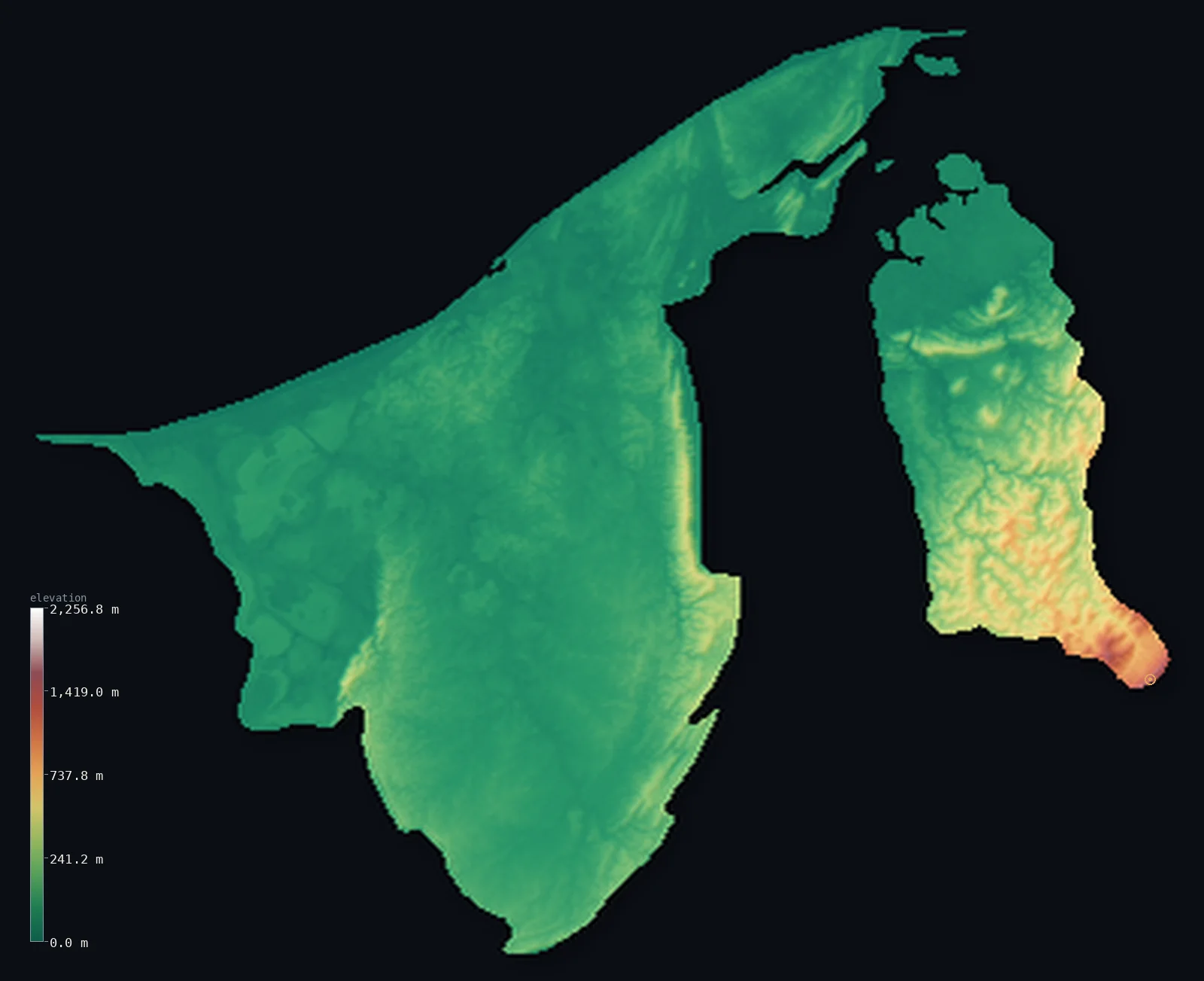
Brunei’s highest point is Bukit Pagon at 6,070 ft (1,850 m); its lowest is South China Sea at 0 ft (0 m); the mean elevation is 322 ft (98.1 m).
Brunei is a small, heavily forested state on the northwest coast of Borneo, and most of it is low. A swampy South China Sea coastal plain rises to dissected hilly lowland inland — the larger western arm, holding the capital, the oilfields and most Bruneians — so half the country lies below about 153 ft (46.6 m). Real mountains rise only in the smaller eastern arm, Temburong, cut off from the rest of Brunei by Malaysia's Limbang corridor: it climbs to the Bornean main range at Bukit Pagon, about 6,070 ft (1,850 m), on the Sarawak border. Both parts of the two-piece country are shown here.
- Highest point📚
- 6,070 ft1,850 m
- Brunei's highest point is Bukit Pagon, about 6,070 ft (1,850 m), a remote jungle peak of the Bornean main range in the southern Temburong arm, on the border with Sarawak (Malaysia). Its summit is a border top — a slightly higher southern top (~1,875 m) lies entirely in Malaysia — and the highest ground the model reads fully within Brunei is about 1,660 m. It stands in near-impenetrable rainforest, effectively unreachable from within Brunei.
- Lowest point📚
- 0 ft0 m
- Brunei's lowest point is sea level, along its 161 km South China Sea coast — a flat, swampy plain of mangrove and tidal river mouths, where the capital, Bandar Seri Begawan, sits on the Brunei River estuary.
- Mean elevation⚙
- 322 ft98.1 m
- Computed from the GLO-30 model, Brunei's mean elevation is 322 ft (98.1 m) — modest, for most of Brunei is low coastal plain and hilly lowland. Half the country lies below about 153 ft (46.6 m); real mountains rise only in the smaller eastern arm, Temburong, at Bukit Pagon.
- Median elevation⚙
- 153 ft46.6 m
- Half of Brunei lies below about 153 ft (46.6 m) — the country is mostly low, a swampy coastal plain rising to dissected hilly lowland, with high ground confined to the mountainous Temburong arm in the south.
- Elevation range📚
- 6,070 ft1,850 m
- From the coast to Bukit Pagon at about 1,850 m, Brunei's terrain spans about 6,070 ft — but almost all of that height is in the remote Temburong arm; the populous western arm is low coastal plain and hills.
- Above 50 m (164 ft)⚙
- 47%
- About 47% of Brunei rises above 50 m (164 ft) — the hilly lowlands inland from the western coast and the mountains of the Temburong arm. The coastal plain, where most Bruneians live, lies lower.
- Official area📚
- 2,226 mi²5,765 km²
- Brunei covers about 2,226 sq mi (5,765 sq km) — a small, oil-rich, heavily forested state on the northwest coast of Borneo, in two parts (a larger western arm and the mountainous Temburong arm) separated by Malaysia's Limbang corridor.
- Forest cover📚
- 72%
- About 72% of Brunei is forest — among the highest proportions in Asia, including some of the best-preserved rainforest left on Borneo, much of it protected in the Temburong interior.
Highest and lowest points
Brunei's highest point is Bukit Pagon, about 6,070 ft (1,850 m), a remote jungle peak of the Bornean main range in the southern Temburong arm, on the border with Sarawak (Malaysia). The summit on the Brunei border is the northern of two close tops; a slightly higher southern top (~1,875 m) lies entirely in Malaysia — so Bukit Pagon is a border summit, and the highest ground the model reads fully within Brunei is about 1,660 m. It sits in near-impenetrable rainforest and is effectively inaccessible from within Brunei; the usual route to the summit is from the Malaysian side. From this high corner the land falls away north through the forested Temburong hills to the South China Sea coast.
source ↗Brunei's lowest ground is its South China Sea coast, at sea level — a flat, swampy plain of mangrove, sandy beaches and tidal rivers running 161 km along the shore. The capital, Bandar Seri Begawan, and its centuries-old stilt village Kampong Ayer sit on the Brunei River estuary here. Inland from the western coast the land rises into dissected hilly lowlands of dense forest, the heart of the oil and gas country. The mountains lie in the other, smaller part of the country: the Temburong arm, cut off from the rest of Brunei by Malaysia's Limbang corridor, sweeps up from the coast into the rainforested Bornean range at Bukit Pagon. Both parts of the two-piece country are shown on this map, the Malaysian salient between them appearing as non-Brunei ground.
source ↗Bukit Pagon is a border summit: its peak lies just outside the generalized Brunei boundary, so the highest fully in-territory land pixel in the model is 5,445 ft (1,660 m). The headline figure above is the surveyed elevation of the recognised national high point.
Brunei at a glance
Brunei is split into two separate parts by the Malaysian district of Limbang, making it almost an enclave within Sarawak — the smaller eastern arm, Temburong, holds the country's mountains.
source ↗Brunei's highest point, Bukit Pagon (~1,850 m), is so deep in jungle that it is effectively inaccessible from within Brunei — the usual route to the summit is from the Malaysian side.
source ↗The Bukit Pagon summit on Brunei's border is the lower northern of two close tops; a slightly higher southern top (~1,875 m) lies entirely in Malaysia.
source ↗About 72% of Brunei is still forest — among the highest proportions in Asia — including some of the best-preserved rainforest left on Borneo.
source ↗Centuries ago Brunei controlled roughly a quarter of Borneo, but is now confined to a small patch of the northwest coast.
source ↗The capital's Kampong Ayer is a centuries-old 'water village' of stilt houses over the Brunei River estuary — one of the largest settlements of its kind in the world.
source ↗Ulu Temburong National Park, the 'Green Jewel of Brunei', protects nearly pristine rainforest reached mainly by longboat, with a canopy walkway high above the trees.
source ↗
Elevation profile of Brunei
The largest share of land, 88%, falls in the 0–200 m band, and 96% of the territory lies below 500 m (1,640 ft).
- 0–10 m (0–33 ft)10%
- 10–50 m (33–164 ft)43%
- above 50 m (164 ft)47%
Highest peaks of Brunei
| Peak | Elevation | Range | Note |
|---|---|---|---|
| Bukit Pagon↗ | 6,070 ft1,850 m | Bornean main range (Temburong) | Highest point of Brunei, a remote jungle peak on the Sarawak border in the Temburong arm. |
| Bukit Retak↗ | 5,308 ft1,618 m | Temburong highlands | A high peak of the Temburong interior, within Brunei's mountainous southern arm. |
| Bukit Belalong↗ | 2,995 ft913 m | Temburong highlands | A forested peak in Ulu Temburong National Park, the 'Green Jewel of Brunei', known for its canopy walkway. |
Brunei: the coastal plain and western arm, the Temburong mountains, and a two-part country
The coastal plain and the western arm
A flat, swampy South China Sea coastal plain runs along Brunei's 161 km shore, fringed with mangrove and threaded by tidal rivers — the capital, Bandar Seri Begawan, and its stilt village Kampong Ayer sit on the Brunei River estuary. Inland the land rises into dissected hilly lowlands of dense forest, the heart of the oil and gas country.
The Temburong mountains — the east
The smaller eastern arm, Temburong, sweeps up from the coast into the rugged, rainforested Bornean main range, culminating at Bukit Pagon (about 1,850 m, on the Sarawak border). Most of it is protected wilderness, including Ulu Temburong National Park, the 'Green Jewel of Brunei'.
A two-part country
Brunei is split into two non-contiguous parts by Malaysia's Limbang district, making it almost an enclave within Sarawak — the low, populous western arm, and the mountainous Temburong arm. Both parts render on this map, with the Malaysian salient between them appearing as non-Brunei ground.
How to read this map
Color shows elevation; the raised relief shows real terrain. On this map Brunei reads as mostly low — the green of the coastal plain and hilly lowlands filling the western arm — with the high browns of the Bornean range gathered in the smaller eastern Temburong arm (highest at Bukit Pagon, on the Malaysian border). The strip of Malaysia (Limbang) that splits the country appears as blank, non-Brunei ground between the two parts.
The 3D relief is the actual GLO-30 elevation data, exaggerated vertically so the low coast and the Temburong mountains both show; the ×N relief slider controls how much. Tap anywhere to read that point's exact elevation.
City elevations in Brunei
Brunei's people cluster on the coast of the western arm — Bandar Seri Begawan, the capital, on the Brunei River, with Kuala Belait in the western oil country and Tutong between them. Across Malaysia's Limbang corridor, Bangar is the small town of the mountainous Temburong arm.
| City | Population | Elevation |
|---|---|---|
| Bandar Seri Begawancapitalthe capital, on the coastal plain of the western arm beside the Brunei River, with the Kampong Ayer stilt village on the estuary ↗ | 64,409 | 16 ft5 m |
| Kuala Belaiton the west coast, in Brunei's main oil and gas district ↗ | 31,178 | 13 ft4 m |
| Tutongon the west-coast plain between the capital and the oilfields ↗ | 19,151 | 16 ft5 m |
| Serasa | 18,569 | 20 ft6 m |
| Liang | 16,813 | 36 ft11 m |
| Pengkalan Batu | 11,560 | 46 ft14 m |
| Bangarthe town of the Temburong arm, gateway to the mountainous, rainforested interior ↗ | 3,970 | 10 ft3 m |
| Lamunin | 3,641 | 46 ft14 m |
Elevation sampled at each city centre from the Copernicus GLO-30 model. Cities and population from GeoNames (CC-BY 4.0).
Brunei in comparison
Brunei's terrain rises 6,070 ft (1,850 m) from sea level to Bukit Pagon — about 21% of the height of Mount Everest, the world's highest point at 29,032 ft (8,849 m).
- Malaysia's mean elevation is 902 ft — 580 ft higher; its high point, Mount Kinabalu (Low's Peak), reaches 13,435 ft (4,095 m), 7,365 ft above. Malaysia elevation map →
- Singapore's mean elevation is 56 ft — 266 ft lower; its high point, Bukit Timah Hill, reaches 538 ft (164 m), 5,531 ft below. Singapore elevation map →
- Timor-Leste's mean elevation is 1,562 ft — 1,240 ft higher; its high point, Tatamailau (Mount Ramelau), reaches 9,721 ft (2,963 m), 3,652 ft above. Timor-Leste elevation map →
Frequently asked questions
What is the highest point in Brunei?
- Bukit Pagon, 6,070 ft (1,850 m), a remote jungle peak in the southern Temburong District on the Sarawak (Malaysia) border.
Can you climb Bukit Pagon from Brunei?
- Not really — it sits in nearly impenetrable jungle and is effectively inaccessible from within Brunei, so the usual route to the summit is from the Malaysian side.
What is the average elevation of Brunei?
- Computed from the Copernicus GLO-30 model, the area-weighted mean is 322 ft (98.1 m). Most of Brunei is low coastal plain and hilly lowland, rising to mountains only in the Temburong arm.
Why is Brunei in two parts?
- The Malaysian district of Limbang, in Sarawak, separates Brunei into two non-contiguous parts — a larger western arm and a smaller eastern arm (Temburong) — making it almost an enclave within Malaysia.
Is Brunei mountainous?
- Mostly no — it is largely flat coastal plain and hilly lowland. Real mountains appear only in the southern Temburong arm, where Bukit Pagon reaches about 1,850 m. 12% of the land lies 200 m (656 ft) or more above sea level.
What is Ulu Temburong?
- Ulu Temburong National Park — the 'Green Jewel of Brunei' — protects nearly pristine rainforest in the eastern arm, reached mainly by longboat and famous for its canopy walkway.
How forested is Brunei?
- Heavily — about 72% of the country is forest, among the highest proportions in Asia, including some of the best-preserved rainforest on Borneo.
Is this a topographic, relief, contour, or elevation map of Brunei?
- They describe the same thing — terrain height. This page renders Brunei's actual elevation surface in interactive 3D (a relief or topographic view) and reports the elevation statistics computed from it; a contour map shows the same data as lines of equal height.
About this map
The terrain is rendered from the Copernicus GLO-30 digital elevation model (ESA), masked to the BRN-ADM0 boundary from geoBoundaries (gbOpen). Elevation statistics are computed directly from the model; peak names and researched facts are sourced and cited. See the methodology for the full pipeline.
Our area-weighted mean, computed from the Copernicus GLO-30 model, is 322 ft (98.1 m); no authority publishes a mean elevation (no authoritative published mean). Brunei is a small, heavily forested state on the northwest coast of Borneo, and most of it is low. A swampy South China Sea coastal plain rises to dissected hilly lowland inland — the western arm, holding the capital, the oilfields and most Bruneians. So half of Brunei lies below about 153 ft (46.6 m). Real mountains rise only in the smaller eastern arm, Temburong — cut off from the rest of the country by Malaysia's Limbang corridor — which climbs to the Bornean main range at Bukit Pagon (about 1,850 m) on the Sarawak border. No standard source publishes a mean elevation for so small a country; the figure here is computed from the GLO-30 model.
Surveyed national figures: official area · forest cover · high point.
Rendered from Copernicus GLO-30 (ESA, 2021 release), boundaries from geoBoundaries. Generated 2026-06-22.
Bordering countries · 1
Brunei shares a land border with these countries — open any one to compare its terrain and highest point.