Timor-Leste Elevation Map — Topographic & 3D Terrain
Explore the terrain of Timor-Leste in interactive 3D, built from Copernicus GLO-30 satellite elevation data — a small, very mountainous half-island country, its central range rising to Tatamailau. Drag to rotate, scroll to zoom, and tap any point to read its elevation.
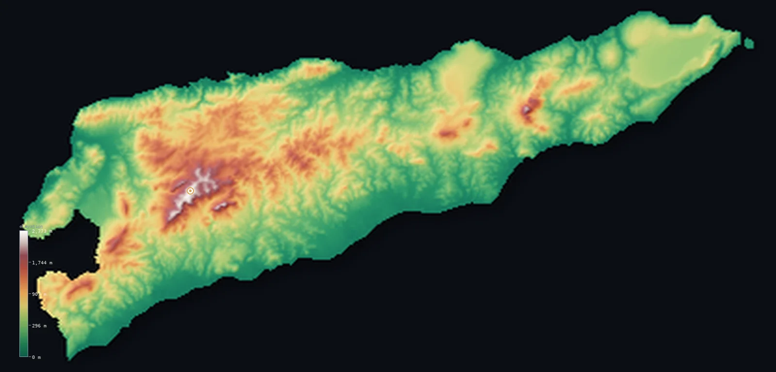
Timor-Leste’s highest point is Tatamailau (Mount Ramelau) at 9,721 ft (2,963 m); its lowest is Timor Sea at 0 ft (0 m); the mean elevation is 1,562 ft (476 m).
Timor-Leste is one of the most mountainous countries in Southeast Asia. It holds the eastern half of the island of Timor, and most of that territory is a rugged, folded mountain range running east to west, rising to Tatamailau (Mount Ramelau) at 9,721 ft (2,963 m) — the highest peak on the whole island. Deep gorges cut down to narrow coastal plains on the north and south, so much of the country is highland that half of it lies above about 1,178 ft (359 m). To the west, a land border separates it from Indonesian West Timor; the Oecusse exclave and the island of Atauro lie apart, beyond the area shown here.
- Highest point📚
- 9,721 ft2,963 m
- Timor-Leste's highest point is Tatamailau — also called Mount Ramelau — at 9,721 ft (2,963 m), in the central Ramelau Range about 70 km south of the capital, Dili. It is the highest mountain on the whole island of Timor, an interior summit of the rugged range that fills most of the country.
- Lowest point📚
- 0 ft0 m
- Timor-Leste's lowest point is sea level, along its north and south coasts — narrow strips of lowland between the mountains and the sea, the north coast dry and steep-backed, the south a little broader and wetter.
- Mean elevation⚙
- 1,562 ft476 m
- Computed from the GLO-30 model, Timor-Leste's mean elevation is 1,562 ft (476 m) — high, for the country is very mountainous: a rugged central range runs the length of the eastern half of Timor island, rising to Tatamailau. Half the country lies above about 1,178 ft (359 m); only the narrow coastal plains lie low.
- Median elevation⚙
- 1,178 ft359 m
- Half of Timor-Leste lies above about 1,178 ft (359 m) — a high midpoint, for the country is dominated by its central mountain range. Only the thin strips of coastal lowland on the north and south coasts, and the valley floors, lie low.
- Elevation range📚
- 9,721 ft2,963 m
- From the sea to the summit of Tatamailau at 2,963 m, Timor-Leste's terrain spans about 9,721 ft — a great rise for so small a half-island country, from coastal plain up to the highest peak on Timor.
- Above 1,000 m (3,281 ft)⚙
- 12%
- About 12% of Timor-Leste rises above 1,000 m (3,281 ft) — the central mountain range that runs the length of the country, from the Ramelau massif (with Tatamailau) to the Matebian massif in the east. The coastal lowlands lie below.
- Official area📚
- 5,743 mi²14,874 km²
- Timor-Leste covers about 5,743 sq mi (14,874 sq km) — a small, very mountainous country holding the eastern half of the island of Timor, plus the Oecusse exclave on the island's northwest coast and the island of Atauro. Indonesia holds the western half of Timor.
- Forest cover📚
- 46.1%
- About 46% of Timor-Leste is wooded — forest on the wetter mountain slopes, thinning to grass and scrub where the steep land has been cleared or burned for farming.
Highest and lowest points
Timor-Leste's highest point is Tatamailau, also called Mount Ramelau, at 9,721 ft (2,963 m), in the central Ramelau Range about 70 km south of the capital, Dili — the highest mountain not only of Timor-Leste but of the whole island of Timor. It is a deep interior summit of the rugged range that runs the length of the country; from its top, on a clear day, both the north and south coasts can be seen. A statue of the Virgin Mary stands on the summit, the site of an annual pilgrimage. (Some tourism sources give 2,986 m, but Wikipedia, Britannica and the CIA all cite 2,963 m.) From this high spine the land drops steeply through gorges to the narrow coastal plains.
source ↗Timor-Leste's lowest ground is its coastline, at sea level. The north coast, where the capital Dili sits, is generally dry and steep-backed, with only a thin plain; the south coast, facing the Timor Sea, has somewhat wider, wetter lowlands. Between and above them rises the country's defining feature: a rugged central mountain range, folded and deeply gorged, running the length of the eastern half of Timor island. It climbs to Tatamailau (2,963 m), the highest point of the country and of the whole island, in the Ramelau Range, with the Matebian massif a second great height in the east. To the west, a land border divides Timor-Leste from Indonesian West Timor. Two further pieces of the country lie apart, beyond the area shown here: the Oecusse exclave on the northwest coast of Timor, surrounded by Indonesian territory, and the island of Atauro (rising to Mount Manucoco, about 999 m) north of Dili.
source ↗Timor-Leste at a glance
Tatamailau was once officially the highest mountain of Portugal, when Timor-Leste was a Portuguese colony.
source ↗Timor-Leste is the only country in Asia lying entirely in the Southern Hemisphere.
source ↗From Tatamailau's summit you can see both the north and south coasts of the country on a clear day.
source ↗The country's territory is split - it holds the eastern half of Timor plus the separate Oecusse exclave on the island's northwest coast.
source ↗A statue of the Virgin Mary stands on the summit, and the mountain is the site of an annual pilgrimage.
source ↗
Elevation profile of Timor-Leste
The largest share of land, 31%, falls in the 0–200 m band, and 64% of the territory lies below 500 m (1,640 ft).
- below 500 m (1,640 ft)64%
- 500–1,000 m23%
- 1,000–2,000 m12%
- above 2,000 m (6,562 ft)1%
Highest peaks of Timor-Leste
| Peak | Elevation | Range | Note |
|---|---|---|---|
| Tatamailau (Mount Ramelau)↗ | 9,721 ft2,963 m | Ramelau Range | Highest point of Timor-Leste and of Timor island; the eastern Matebian massif is the country's other great peak, and Atauro island rises to Mount Manucoco (999 m). |
Timor-Leste: the central mountains, the coastal plains, and the Oecusse exclave and islands
The central mountains
Most of the main territory is a rugged, folded mountain range running east to west, rising to Tatamailau (2,963 m) in the Ramelau Range near the centre, with the Matebian massif a second great height in the east. Deep gorges cut down from the ridges to both coasts — the interior is almost entirely mountainous.
The coastal plains
Between the mountains and the sea lie narrow coastal lowlands. The north coast, where Dili sits, is dry and steep-backed, with only a thin plain; the south coast, facing the Timor Sea, has somewhat wider, wetter plains. These lowlands hold much of the farmland and most of the larger towns.
The Oecusse exclave and islands
Timor-Leste also includes Oecusse, an exclave on the northwest coast of Timor cut off from the rest of the country by Indonesian West Timor, and two islands — Atauro (rising to Mount Manucoco, ~999 m) north of Dili, and tiny Jaco off the eastern tip. This map renders the main eastern territory; the separated Oecusse exclave and Atauro lie apart, beyond the area shown.
How to read this map
Color shows elevation; the raised relief shows real terrain. On this map Timor-Leste reads as almost all mountain — a rugged spine of high browns and whites running the length of the eastern half of Timor island (highest at Tatamailau in the centre), dropping steeply through gorges to thin green coastal strips on the north and south. The western edge is a land border with Indonesia.
The 3D relief is the actual GLO-30 elevation data, exaggerated vertically so the deep gorges and high ridges show; the ×N relief slider controls how much. Tap anywhere to read that point's exact elevation. (The Oecusse exclave and Atauro island lie beyond the area shown.)
City elevations in Timor-Leste
Timor-Leste's towns line the coasts and dot the valleys — Dili, the capital, on the north coast below the mountains, with Baukau further east along the north coast, Likisá to the west, Suai and Viqueque on the southern side, and Maliana inland near the Indonesian border. Most people live low, on the coast or in the valleys, below the steep central range.
| City | Population | Elevation |
|---|---|---|
| Dilicapitalthe capital, on the north coast on a narrow strip of lowland below the central mountains ↗ | 150,000 | 16 ft5 m |
| Malianain a western valley near the border with Indonesian West Timor ↗ | 22,000 | 827 ft252 m |
| Suaion the broader southern coastal plain, facing the Timor Sea ↗ | 21,539 | 236 ft72 m |
| Likisá | 19,000 | 69 ft21 m |
| Lospalos | 17,186 | 1,283 ft391 m |
| Atsabe | 16,304 | 4,032 ft1,229 m |
| Baukauon the north coast east of Dili, Timor-Leste's second town ↗ | 16,000 | 1,450 ft442 m |
| Venilale | 16,000 | 2,723 ft830 m |
| Hatoudo | 10,299 | 1,447 ft441 m |
| Viqueque | 6,078 | 187 ft57 m |
Elevation sampled at each city centre from the Copernicus GLO-30 model. Cities and population from GeoNames (CC-BY 4.0).
Timor-Leste in comparison
Timor-Leste's terrain rises 9,721 ft (2,963 m) from sea level to Tatamailau (Mount Ramelau) — about 33% of the height of Mount Everest, the world's highest point at 29,032 ft (8,849 m).
- Indonesia's mean elevation is 1,112 ft — 449 ft lower; its high point, Puncak Jaya (Carstensz Pyramid), reaches 16,024 ft (4,884 m), 6,302 ft above. Indonesia elevation map →
- Philippines's mean elevation is 1,053 ft — 509 ft lower; its high point, Mount Apo, reaches 9,692 ft (2,954 m), 30 ft below. Philippines elevation map →
- Papua New Guinea's mean elevation is 2,113 ft — 551 ft higher; its high point, Mount Wilhelm, reaches 14,793 ft (4,509 m), 5,072 ft above. Papua New Guinea elevation map →
Frequently asked questions
What is the highest point in Timor-Leste?
- Tatamailau, also called Mount Ramelau, 9,721 ft (2,963 m), in the central Ramelau Range - the highest mountain on the whole island of Timor.
What is the average elevation of Timor-Leste?
- No standard source publishes one, so this page reports the mean computed from the Copernicus GLO-30 model, 1,562 ft (476 m), over a mostly mountainous land.
What is the lowest point in Timor-Leste?
- Sea level, along its north and south coasts.
How tall is Mount Ramelau?
- Wikipedia, Britannica and the CIA give 2,963 m; some tourism sources cite 2,986 m. Either way it is the highest point in the country.
Does Timor-Leste share the island of Timor?
- Yes - it holds the eastern half of Timor plus the Oecusse exclave, while Indonesia holds the western half (West Timor).
Is this a topographic, relief, contour, or elevation map of Timor-Leste?
- They describe the same thing - terrain height. This page renders Timor-Leste's actual elevation surface in interactive 3D (a relief or topographic view) and reports the elevation statistics computed from it; a contour map shows the same data as lines of equal height.
About this map
The terrain is rendered from the Copernicus GLO-30 digital elevation model (ESA), masked to the TLS-ADM0 boundary from geoBoundaries (gbOpen). Elevation statistics are computed directly from the model; peak names and researched facts are sourced and cited. See the methodology for the full pipeline.
Our area-weighted mean, computed from the Copernicus GLO-30 model, is 1,562 ft (476 m); no authority publishes a mean elevation (No authoritative published mean elevation). Timor-Leste is one of the most mountainous countries in Southeast Asia. It occupies the eastern half of the island of Timor, and most of that territory is a rugged, folded mountain range running east to west, rising to Tatamailau (Mount Ramelau, 2,963 m) in the centre and the Matebian massif in the east. Deep gorges cut down to narrow coastal plains on the north and south. So much of the country is highland that half of it lies above about 1,178 ft (359 m). To the west a land border separates it from Indonesian West Timor; the Oecusse exclave and the island of Atauro lie apart from the main territory, beyond the area shown on this map. No standard source publishes a mean elevation; the figure here is computed from the GLO-30 model.
Surveyed national figures: official area · forest cover · high point.
Rendered from Copernicus GLO-30 (ESA, 2021 release), boundaries from geoBoundaries. Generated 2026-07-07.
Bordering countries · 1
Timor-Leste shares a land border with these countries — open any one to compare its terrain and highest point.