Indonesia Elevation Map — Topographic & 3D Terrain
Explore the terrain of Indonesia in interactive 3D, built from Copernicus GLO-30 satellite elevation data — the largest archipelago on Earth, a chain of volcanic islands spanning an eighth of the globe. Drag to rotate, scroll to zoom, and tap any point to read its elevation.
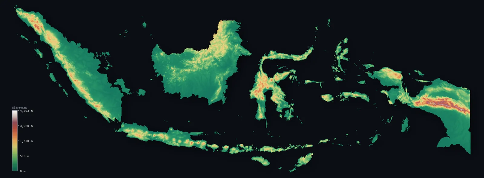
Indonesia’s highest point is Puncak Jaya (Carstensz Pyramid) at 16,024 ft (4,884 m); its lowest is Indian Ocean at 0 ft (0 m); the mean elevation is 1,112 ft (339 m).
Indonesia stretches across an eighth of the Earth's circumference — more than 17,000 islands strung along the equator from the Indian Ocean to the Pacific. Volcanoes run the length of it, in the great arc of the Sunda chain through Sumatra, Java, and the islands beyond, and the country sits at the heart of the Pacific Ring of Fire. In the far east, on the island of New Guinea, the land climbs highest of all: Puncak Jaya reaches 16,024 ft (4,884 m) — the highest mountain on any island on Earth and the highest point of Oceania — and still carries equatorial glaciers.
- Highest point📚
- 16,024 ft4,884 m
- Indonesia's highest point is Puncak Jaya at 16,024 ft (4,884 m), in the Sudirman Range of Papua on the island of New Guinea — the highest peak in Indonesia, the highest mountain on any island on Earth, and the highest point of Oceania. It carries some of the last equatorial glaciers on Earth, a shrinking icecap almost on the equator, on a summit of rock that is geologically part of Australia rather than the volcanic arc.
- Lowest point📚
- 0 ft0 m
- Indonesia's lowest point is the sea at sea level, around the coasts of more than 17,000 islands — an immense combined shoreline of reef, mangrove, and volcanic sand spanning the width of a continent.
- Mean elevation⚙
- 1,112 ft339 m
- Computed from the GLO-30 model, Indonesia's mean elevation is 1,112 ft (339 m) — a modest figure that averages an enormous range: vast low coastal and swamp plains on the larger islands, and steep volcanic and mountainous interiors that rise, in Papua, above 4,800 m.
- Median elevation⚙
- 341 ft104 m
- Half of Indonesia lies below 341 ft (104 m) — a low median, the mark of an archipelago whose great islands carry broad low coastal plains, swamp, and lowland forest, with the volcanic highlands and the mountains of Papua a steep minority of the land.
- Elevation range📚
- 16,024 ft4,884 m
- From the sea to the glaciated summit of Puncak Jaya, Indonesia spans about 16,020 ft — from equatorial coast to equatorial ice, most of the height held in the mountains of Papua and the volcanic peaks of the Sunda arc.
- Above 1,000 m (3,281 ft)⚙
- 10%
- About 10% of Indonesia rises above 1,000 m (3,281 ft) — the volcanic highlands running through Sumatra, Java, and the eastern islands, and the high central ranges of Papua. The great bulk of the country is lower, coastal and lowland.
- Above 2,000 m (6,562 ft)⚙
- 2%
- Roughly 2% of Indonesia stands above 2,000 m (6,562 ft) — the high volcanic peaks of the Sunda arc and the central ranges of Papua that climb toward Puncak Jaya.
- Official area📚
- 735,358 mi²1,904,569 km²
- Indonesia covers about 735,000 sq mi (1,904,569 sq km) of land across more than 17,000 islands — the largest being Sumatra, Borneo (shared), Sulawesi, Java, and New Guinea (shared) — spread over a span of ocean as wide as the United States.
- Forest cover📚
- 49.1%
- About 49.1% of Indonesia is forested — vast tracts of tropical rainforest, among the largest and most biodiverse on Earth, cloaking the interiors of Sumatra, Borneo, and Papua, though much reduced by logging and plantation.
Highest and lowest points
Indonesia's highest point is Puncak Jaya, 16,024 ft (4,884 m), in the Sudirman Range of Papua — the highest peak of the whole country and the highest mountain on any island on Earth. It is unlike the rest of Indonesia's high ground: not a volcano but a summit of uplifted limestone, geologically part of the Australian continent, and high enough to carry glaciers almost on the equator. Those glaciers are the last in the tropics of the western Pacific and are vanishing fast, expected to disappear within years. The peak is also known as Carstensz Pyramid, and is the highest summit of Oceania.
source ↗Indonesia's lowest point is the sea at sea level, around the coasts of more than 17,000 islands spread across some 5,000 km of ocean — a combined coastline among the longest of any country. The larger islands carry broad low ground behind their shores: the swamp forests and peatlands of eastern Sumatra and southern Borneo, the alluvial plains of Java, and the vast lowland swamps of southern Papua, much of it barely above the tide.
source ↗Indonesia at a glance
Puncak Jaya (4,884 m) in Papua is the highest mountain on any island on Earth and the highest point of Oceania — and one of the very few equatorial mountains on Earth to carry glaciers.
source ↗Indonesia is made up of more than 17,000 islands spread across some 5,000 km of ocean — the largest archipelago on Earth, spanning an eighth of the globe's circumference.
source ↗Indonesia sits at the heart of the Pacific Ring of Fire and has more active volcanoes than any other country — around 130 — including Krakatoa and Tambora, whose 1815 eruption was the largest in recorded history.
source ↗Puncak Jaya is not a volcano but a summit of uplifted limestone, geologically part of the Australian continent rather than the volcanic Sunda arc.
source ↗The equator runs through the middle of Indonesia, crossing Sumatra, Borneo, and Sulawesi — the country lies in both the northern and southern hemispheres.
source ↗Indonesia's rainforests, on Sumatra, Borneo, and Papua, are among the largest and most biodiverse on Earth, home to species found nowhere else.
source ↗As the highest point of Oceania, Puncak Jaya (Carstensz Pyramid) is one of the Seven Summits — the highest peaks of the seven continents — and lies in a remote corner reached only by days of trekking or helicopter.
source ↗
Elevation profile of Indonesia
The largest share of land, 77%, falls in the 0–500 m band, and 77% of the territory lies below 500 m (1,640 ft).
- below 500 m (1,640 ft)77%
- 500–1,000 m13%
- 1,000–2,000 m8%
- above 2,000 m (6,562 ft)2%
Highest peaks of Indonesia
| Peak | Elevation | Range | Note |
|---|---|---|---|
| Puncak Jaya (Carstensz Pyramid)↗ | 16,024 ft4,884 m | Sudirman Range (Papua) | Highest point of Indonesia and of Oceania, and the highest island peak on Earth; in Papua. |
| Sumantri↗ | 15,978 ft4,870 m | Sudirman Range (Papua) | A neighbouring summit of Puncak Jaya in the Papuan highlands. |
| Gunung Kerinci↗ | 12,484 ft3,805 m | Barisan Mountains (Sumatra) | The highest volcano in Indonesia and the highest peak of Sumatra, an active stratovolcano. |
| Gunung Rinjani↗ | 12,224 ft3,726 m | Lombok | The second-highest volcano in Indonesia, on the island of Lombok east of Bali. |
| Gunung Semeru↗ | 12,060 ft3,676 m | Tengger (Java) | The highest mountain of Java, an active volcano in the Bromo Tengger Semeru area. |
The Greater Sundas, the volcanic arc, and the Papuan highlands
The Greater Sunda Islands
The largest islands of the west — Sumatra, Java, Borneo (shared with Malaysia and Brunei; Indonesia's share is Kalimantan), and Sulawesi. Volcanic mountain chains run down Sumatra and Java, holding most of the population on their fertile slopes and plains, while Borneo is lower, a vast island of rainforest and swamp.
The volcanic arc (Java and the Lesser Sundas)
The Sunda arc of volcanoes runs east from Sumatra through Java and on through Bali, Lombok, and the Lesser Sunda Islands — a chain of active cones, some of the most active on Earth, rising steeply above narrow coasts. Java alone holds dozens of volcanoes and much of the country's people.
Papua and the eastern highlands
The far east, on the island of New Guinea (shared with Papua New Guinea), carries Indonesia's highest and most rugged terrain — the central ranges rising to Puncak Jaya and its glaciers, above vast lowland swamps and rainforest along the southern coast. A different geology from the volcanic west, and the country's high point.
The coasts, swamps, and lowlands
Across the archipelago, behind thousands of kilometres of coast, lie the low grounds — the peat swamps and forests of eastern Sumatra and southern Borneo, the alluvial plains of Java, the mangroves and swamps of Papua's south — much of it near sea level, and the country's statistical bulk.
How to read this map
Color shows elevation; the raised relief shows real terrain. On this map Indonesia reads as a vast chain of green islands strung west to east along the equator, with volcanic spines running down Sumatra and Java, scattered high ground through Sulawesi and the eastern islands, and the highest terrain — brown and white, capped by Puncak Jaya — gathered in the mountains of Papua at the far east.
The 3D relief is the actual GLO-30 elevation data, exaggerated vertically so the volcanic ranges and the Papuan highlands both show; the ×N relief slider controls how much. Tap anywhere to read that point's exact elevation.
City elevations in Indonesia
Indonesia's cities cluster overwhelmingly on Java — Jakarta, Surabaya, Bandung, Semarang — the crowded volcanic heartland, with Medan and Palembang on Sumatra, Makassar on Sulawesi, and few large cities on the forested giants of Borneo and Papua. Most sit low, on coastal or river plains.
| City | Population | Elevation |
|---|---|---|
| Jakartacapitalthe capital, on the low northern coast of Java — a vast lowland city, parts of it sinking below sea level ↗ | 8,540,121 | 59 ft18 m |
| Surabayaa port city on the northeastern coast of Java ↗ | 3,018,022 | 20 ft6 m |
| Medanon the northern coastal plain of Sumatra ↗ | 2,486,283 | 89 ft27 m |
| Palembang | 1,801,367 | 13 ft4 m |
| Semarang | 1,694,740 | 30 ft9 m |
| Makassara port on the southwestern coast of Sulawesi ↗ | 1,474,393 | 16 ft5 m |
| Batam | 1,296,960 | 108 ft33 m |
| Pekanbaru | 1,167,599 | 59 ft18 m |
| Bandar Lampung | 1,166,066 | 302 ft92 m |
| Padang | 942,938 | 20 ft6 m |
Elevation sampled at each city centre from the Copernicus GLO-30 model. Cities and population from GeoNames (CC-BY 4.0).
Indonesia in comparison
Indonesia's terrain rises 16,024 ft (4,884 m) from sea level to Puncak Jaya (Carstensz Pyramid) — about 55% of the height of Mount Everest, the world's highest point at 29,032 ft (8,849 m).
- Malaysia's mean elevation is 902 ft — 210 ft lower; its high point, Mount Kinabalu (Low's Peak), reaches 13,435 ft (4,095 m), 2,589 ft below. Malaysia elevation map →
- Papua New Guinea's mean elevation is 2,113 ft — 1,001 ft higher; its high point, Mount Wilhelm, reaches 14,793 ft (4,509 m), 1,230 ft below. Papua New Guinea elevation map →
- Philippines's mean elevation is 1,053 ft — 59 ft lower; its high point, Mount Apo, reaches 9,692 ft (2,954 m), 6,332 ft below. Philippines elevation map →
Frequently asked questions
What is the highest point in Indonesia?
- Puncak Jaya, 16,024 ft (4,884 m), in the Sudirman Range of Papua — the highest mountain on any island on Earth and the highest point of Oceania, and one of the few equatorial peaks with glaciers.
What is the lowest point in Indonesia?
- The sea at sea level, around the coasts of its more than 17,000 islands.
What is the average elevation of Indonesia?
- Computed from the Copernicus GLO-30 model, the area-weighted mean is 1,112 ft (339 m) — modest, because the great islands carry vast low coastal plains, with the height in the volcanic highlands and the mountains of Papua.
Does Indonesia have glaciers?
- Yes, barely — on Puncak Jaya in Papua, some of the last equatorial glaciers on Earth, a shrinking icecap almost on the equator that is expected to vanish within years.
Why does Indonesia have so many volcanoes?
- It sits at the heart of the Pacific Ring of Fire, where tectonic plates collide — giving it around 130 active volcanoes, more than any other country, including Krakatoa and Tambora.
Is this a topographic, relief, contour, or elevation map of Indonesia?
- They describe the same thing — terrain height. This page renders the country's actual elevation surface in interactive 3D and reports the statistics computed from it.
About this map
The terrain is rendered from the Copernicus GLO-30 digital elevation model (ESA), masked to the IDN-ADM0 boundary from geoBoundaries (gbOpen). Elevation statistics are computed directly from the model; peak names and researched facts are sourced and cited. See the methodology for the full pipeline.
Our area-weighted mean, computed from the Copernicus GLO-30 model, is 1,112 ft (339 m); the figure commonly cited elsewhere is 1,204 ft (367 m) (CIA World Factbook). Indonesia is a chain of thousands of volcanic and mountainous islands, most land lying at low to moderate elevations with high interior ranges, giving a modest mean; the page reports the area-weighted figure computed from the Copernicus GLO-30 model. The country is shown as several island panels, each rendered at reduced surface resolution.
Surveyed national figures: official area · forest cover · high point.
Rendered from Copernicus GLO-30 (ESA, 2021 release), boundaries from geoBoundaries. Generated 2026-07-26.
Bordering countries · 3
Indonesia shares a land border with these countries — open any one to compare its terrain and highest point.