Malaysia Elevation Map — Topographic & 3D Terrain
Explore the terrain of Malaysia in interactive 3D, built from Copernicus GLO-30 satellite elevation data — a country in two halves, split across the South China Sea, each with a mountainous spine. Drag to rotate, scroll to zoom, and tap any point to read its elevation.
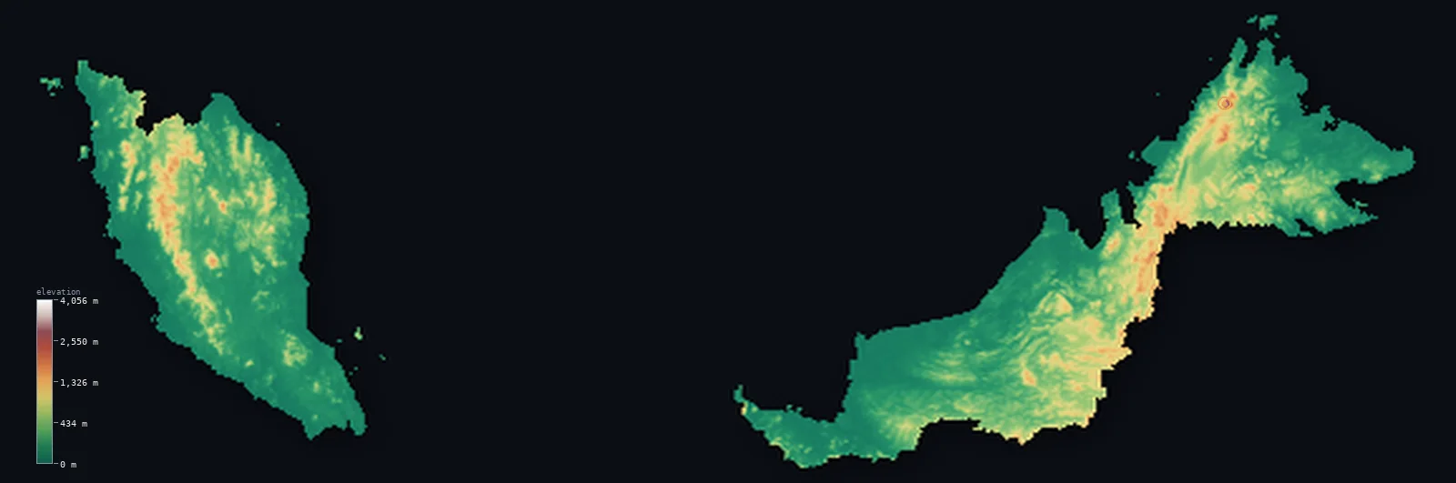
Malaysia’s highest point is Mount Kinabalu (Low's Peak) at 13,435 ft (4,095 m); its lowest is Indian Ocean / South China Sea at 0 ft (0 m); the mean elevation is 902 ft (275 m).
Malaysia comes in two parts, 640 km apart across the South China Sea. Peninsular Malaysia hangs from the Asian mainland, a strip of coastal lowland rising to a forested central range; East Malaysia occupies the northern quarter of Borneo, its coastal plains climbing to the highlands of the interior and, at the summit, Mount Kinabalu at 13,435 ft (4,095 m) — the highest peak between the Himalaya and New Guinea. Most of the country is low: about 58% lies below 656 ft (200 m).
- Highest point📚
- 13,435 ft4,095 m
- Malaysia's highest point is Mount Kinabalu at 13,435 ft (4,095 m), in the state of Sabah on the island of Borneo — a vast granite massif rising far above the surrounding highlands, the tallest mountain in Malaysia and the highest between the Himalaya and the peaks of New Guinea.
- Lowest point📚
- 0 ft0 m
- Malaysia's lowest point is the sea at sea level, on coasts facing the Strait of Malacca, the South China Sea, the Sulu Sea, and the Celebes Sea — the country wraps around a great deal of water on both sides of its two halves.
- Mean elevation⚙
- 902 ft275 m
- Malaysia's mean elevation computed from the GLO-30 model is 902 ft (275 m) — a moderate figure that averages two low coastal countries with mountainous interiors: the great bulk of Malaysia is lowland, with the height concentrated in the central ranges of each half.
- Median elevation⚙
- 430 ft131 m
- Half of Malaysia lies below 430 ft (131 m) — well under the mean, the mark of a country that is mostly low coastal plain and hill, with a minority of high interior mountain pulling the average upward.
- Elevation range📚
- 13,435 ft4,095 m
- From the sea to the summit of Mount Kinabalu, Malaysia spans about 13,400 ft — but almost all of that height belongs to Kinabalu itself, which stands thousands of feet above the next-highest ground in the country.
- Above 1,000 m (3,281 ft)⚙
- 5%
- About 5% of Malaysia rises above 1,000 m (3,281 ft) — the central mountain spine of the peninsula and the interior highlands of Borneo, where the land climbs from the coastal plains into rainforested ranges.
- Official area📚
- 127,724 mi²330,803 km²
- Malaysia covers about 127,700 sq mi (330,803 sq km) in two separate regions — Peninsular Malaysia on the Asian mainland and East Malaysia, the states of Sabah and Sarawak, across the South China Sea on the island of Borneo.
- Forest cover📚
- 58%
- About 58% of Malaysia is forested — one of the higher shares in Asia, much of it tropical rainforest among the oldest on Earth, cloaking both the peninsular range and the mountainous interior of Borneo.
Highest and lowest points
Malaysia's highest point is Mount Kinabalu, 13,435 ft (4,095 m), in Sabah on Borneo — a huge granite dome that is still measurably rising, pushed up faster than it erodes. It towers over everything around it: the next-highest mountains in Malaysia fall thousands of feet short, which makes Kinabalu one of the most prominent peaks in the world. It is the highest point between the Himalaya to the northwest and the mountains of New Guinea to the southeast, and its bare granite summit plateau, scoured smooth by ice-age glaciers, stands high above the rainforest that clothes its lower slopes.
source ↗Malaysia's lowest point is sea level, and the country meets the sea almost everywhere: the Strait of Malacca and the South China Sea on either side of the peninsula, and the South China, Sulu, and Celebes Seas around Sabah and Sarawak. Both halves are lands of long coastlines and broad coastal plains — mangrove, river mouth, and paddy — where most of the population lives, before the ground rises inland toward the mountains.
source ↗Malaysia at a glance
Mount Kinabalu (4,095 m), in Sabah, is the highest peak between the Himalaya and the mountains of New Guinea - and it is still rising faster than it erodes.
source ↗Malaysia is split into two regions 640 km apart - Peninsular Malaysia on the Asian mainland, and Sabah and Sarawak on the island of Borneo - separated by the South China Sea.
source ↗Kinabalu towers thousands of feet above the next-highest peaks in Malaysia, making it one of the most topographically prominent mountains in the world.
source ↗Much of Malaysia is covered in tropical rainforest, among the oldest in the world, on both the peninsula and Borneo.
source ↗Peninsular Malaysia is divided lengthwise by the Titiwangsa range, a forested spine that separates the country's east and west coasts.
source ↗The summit plateau of Mount Kinabalu is bare granite, scoured smooth by glaciers during the last ice age when the mountain carried a small ice cap.
source ↗Mount Kinabalu is the third-highest island peak on Earth.
source ↗East Malaysia wraps around the small, separate country of Brunei on the north coast of Borneo.
source ↗
Elevation profile of Malaysia
The largest share of land, 63%, falls in the 0–250 m band, and 80% of the territory lies below 500 m (1,640 ft).
- below 500 m (1,640 ft)80%
- 500–1,000 m15%
- 1,000–2,000 m5%
- above 2,000 m (6,562 ft)<1%
Highest peaks of Malaysia
| Peak | Elevation | Range | Note |
|---|---|---|---|
| Mount Kinabalu (Low's Peak)↗ | 13,435 ft4,095 m | Crocker Range, Sabah (Borneo) | Highest point of Malaysia and of Borneo, a granite massif and the highest peak between the Himalayas and New Guinea. |
| Gunung Murud↗ | 7,949 ft2,423 m | Kelabit Highlands, Sarawak (Borneo) | The highest peak of Sarawak, in the remote Kelabit Highlands of northern Borneo. |
| Gunung Tahan↗ | 7,175 ft2,187 m | Tahan Range (Peninsular Malaysia) | The highest point of Peninsular Malaysia, deep in Taman Negara national park. |
| Gunung Korbu↗ | 7,162 ft2,183 m | Titiwangsa Range (Peninsular Malaysia) | The second-highest peak of Peninsular Malaysia, in the Titiwangsa spine. |
Two halves, each with a mountain spine
Peninsular Malaysia
The western half hangs south from the Asian mainland — broad coastal plains on the Strait of Malacca and the South China Sea, rising to the Titiwangsa range, a forested mountain spine running down the peninsula's length. Most of the country's people live here, on the coastal lowlands to either side of the range.
The highlands and coasts of Borneo
East Malaysia — Sabah and Sarawak — occupies the northern quarter of Borneo: wide swampy coastal plains and the world's largest cave systems, climbing inland through hill country to a mountainous, rainforested interior along the Indonesian border.
Mount Kinabalu and the Crocker Range
In Sabah the Crocker Range rises to Mount Kinabalu, a granite massif standing far above everything around it — the country's high point and one of the most prominent mountains on Earth, its bare summit plateau a world apart from the rainforest below.
How to read this map
Color shows elevation; the raised relief shows real terrain. On this map Malaysia reads in two pieces — the peninsula with its green central spine, and northern Borneo with its mountainous interior, the single sharp white point of Mount Kinabalu standing out above it all.
The 3D relief is the actual GLO-30 elevation data, exaggerated vertically so the coastal lowlands and the interior ranges both show; the ×N relief slider controls how much. Tap anywhere to read that point's exact elevation.
City elevations in Malaysia
Malaysia's cities are mostly coastal lowland - Kuala Lumpur inland on the peninsula's west side at the foot of the Titiwangsa range, George Town and Johor Bahru on the peninsular coast, Kuching and Kota Kinabalu on Borneo. The mountainous interiors of both halves hold few large towns.
| City | Population | Elevation |
|---|---|---|
| Kuala Lumpurcapitalthe capital, in a valley on the peninsula's west side at the foot of the Titiwangsa range ↗ | 1,453,975 | 197 ft60 m |
| Johor Bahru | 858,118 | 79 ft24 m |
| Ipoh | 759,952 | 148 ft45 m |
| Malacca | 579,000 | 20 ft6 m |
| Kota Bharu | 568,900 | 26 ft8 m |
| Kuantan | 548,014 | 26 ft8 m |
| Kota Kuala Muda | 544,984 | 10 ft3 m |
| Kota Kinabaluon the coast of Sabah beneath Mount Kinabalu, the gateway to the peak ↗ | 500,421 | 30 ft9 m |
| Sandakan | 439,050 | 36 ft11 m |
| Kuala Terengganu | 426,500 | 26 ft8 m |
Elevation sampled at each city centre from the Copernicus GLO-30 model. Cities and population from GeoNames (CC-BY 4.0).
Malaysia in comparison
Malaysia's terrain rises 13,435 ft (4,095 m) from sea level to Mount Kinabalu (Low's Peak) — about 46% of the height of Mount Everest, the world's highest point at 29,032 ft (8,849 m).
- Indonesia's mean elevation is 1,112 ft — 210 ft higher; its high point, Puncak Jaya (Carstensz Pyramid), reaches 16,024 ft (4,884 m), 2,589 ft above. Indonesia elevation map →
- Thailand's mean elevation is 932 ft — 30 ft higher; its high point, Doi Inthanon, reaches 8,415 ft (2,565 m), 5,020 ft below. Thailand elevation map →
- Brunei's mean elevation is 322 ft — 580 ft lower; its high point, Bukit Pagon, reaches 6,070 ft (1,850 m), 7,365 ft below. Brunei elevation map →
Frequently asked questions
What is the highest point in Malaysia?
- Mount Kinabalu, 13,435 ft (4,095 m), in Sabah on Borneo - the highest peak between the Himalaya and the mountains of New Guinea.
What is the lowest point in Malaysia?
- Sea level - the country has long coastlines on both of its halves, on the peninsula and on Borneo.
What is the average elevation of Malaysia?
- Computed from the Copernicus GLO-30 model, the area-weighted mean is 902 ft (275 m) - moderate, because most of the country is low coastal plain with mountains only in the interior of each half.
Why is Malaysia in two parts?
- Malaysia is split across the South China Sea: Peninsular Malaysia on the Asian mainland, and the states of Sabah and Sarawak on the island of Borneo, about 640 km apart.
How high is Mount Kinabalu compared to the rest of Malaysia?
- It stands thousands of feet above the next-highest peaks, making it one of the most prominent mountains in the world - the rest of the country is far lower.
Is this a topographic, relief, contour, or elevation map of Malaysia?
- They describe the same thing - terrain height. This page renders the country's actual elevation surface in interactive 3D and reports the statistics computed from it.
About this map
The terrain is rendered from the Copernicus GLO-30 digital elevation model (ESA), masked to the MYS-ADM0 boundary from geoBoundaries (gbOpen). Elevation statistics are computed directly from the model; peak names and researched facts are sourced and cited. See the methodology for the full pipeline.
Our area-weighted mean, computed from the Copernicus GLO-30 model, is 902 ft (275 m); the figure commonly cited elsewhere is 1,765 ft (538 m) (CIA World Factbook). Malaysia is mostly coastal lowland and hill rainforest with mountainous interiors on both the Malay Peninsula and Borneo, so its mean elevation is moderate; the page reports the area-weighted figure computed from the Copernicus GLO-30 model.
Surveyed national figures: official area · forest cover · high point.
Rendered from Copernicus GLO-30 (ESA, 2021 release), boundaries from geoBoundaries. Generated 2026-07-25.
Bordering countries · 4
Malaysia shares a land border with these countries — open any one to compare its terrain and highest point.