Singapore Elevation Map
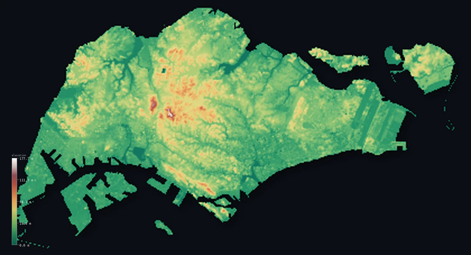
Singapore’s highest point is Bukit Timah Hill at 538 ft (164 m); its lowest is Singapore Strait at 0 ft (0 m); the mean elevation is 56 ft (17 m).
- Highest point📚
- 538 ft164 m
- Bukit Timah Hill, near the centre of the main island.
- Lowest point📚
- 0 ft0 m
- Sea level along the straits.
- Mean elevation⚙
- 56 ft17 m
- Computed from the GLO-30 surface model across the rendered land.
- Median elevation⚙
- 43 ft13 m
- Half of Singapore lies below this height.
- Elevation range📚
- 538 ft164 m
- From the sea to Bukit Timah Hill's 164 m.
- Above 50 m (164 ft)⚙
- 4%
- The low central hills and water-catchment ridges.
- Official area📚
- 281 mi²728 km²
- A compact, low-lying island city-state.
- Forest cover📚
- 22.1%
- About a fifth wooded - nature reserves amid dense city.
Highest and lowest points
The highest natural point of Singapore at 164 m - Bukit Timah Hill, a granite rise near the geographical centre of the main island, within the Bukit Timah Nature Reserve. (Many buildings are taller, but they are not terrain.) It is interior, not on a border.
source ↗Singapore at a glance
Singapore's highest natural point, Bukit Timah Hill, is only 164 m - lower than many of the city's skyscrapers.
source ↗Most of the country lies no more than about 15 m above sea level.
source ↗Land reclamation has grown Singapore from about 582 km2 in the 1960s to roughly 745 km2 today.
source ↗Bukit Timah Hill is granite, and its forested reserve is one of the few patches of primary rainforest within a city anywhere.
source ↗Singapore has no natural lakes - its reservoirs were all built to store fresh water.
source ↗
Elevation profile of Singapore
The largest share of land, 69%, falls in the 0–20 m band, and 100% of the territory lies below 500 m (1,640 ft).
- 0–10 m (0–33 ft)39%
- 10–50 m (33–164 ft)57%
- above 50 m (164 ft)4%
Highest peaks of Singapore
Terrain regions of Singapore
Singapore's highest natural point, Bukit Timah Hill, is only 164 m - lower than many of the city's skyscrapers. ↗
The main island
↗Singapore Island holds the great majority of the land and people - a diamond-shaped island about 50 km east to west, low and largely urbanised, with a small core of granite hills and forested water-catchment reserves at its centre.
The smaller islands
↗Dozens of smaller islands surround the mainland - the larger ones being Pulau Tekong and Pulau Ubin in the northeast, and Sentosa and the reclaimed Jurong Island in the south and west.
The central hills
the central coreNear the middle of the main island a small range of low granite hills rises above the city - Bukit Timah (164 m), the highest natural point, with Bukit Gombak and others nearby. These hills hold the Bukit Timah and Central Catchment nature reserves, Singapore's forested 'green heart', along with the main reservoirs.
The low plains and coast
most of the countryMost of Singapore lies no more than about 15 m above the sea. Sedimentary hills and valleys make up the northwest, while the east is flatter, sandy ground. Much of the southern and eastern shoreline - including the downtown waterfront and the airport - is reclaimed land, part of a long expansion that has grown the country from about 582 km2 in the 1960s to roughly 745 km2 today.
City elevations in Singapore
| City | Population | Elevation |
|---|---|---|
| Singaporecapital | 5,638,700 | 39 ft12 m |
| Woodlands | 254,440 | 92 ft28 m |
| Boon Lay | 29,510 | 36 ft11 m |
| Loyang | 15,340 | 23 ft7 m |
Elevation sampled at each city centre from the Copernicus GLO-30 model. Cities and population from GeoNames (CC-BY 4.0).
Singapore in comparison
Singapore's terrain rises 538 ft (164 m) from sea level to Bukit Timah Hill — about 2% of the height of Mount Everest, the world's highest point at 29,032 ft (8,849 m).
- Malaysia's mean elevation is 902 ft — 846 ft higher; its high point, Mount Kinabalu (Low's Peak), reaches 13,435 ft (4,095 m), 12,897 ft above. Malaysia elevation map →
- Brunei's mean elevation is 322 ft — 266 ft higher; its high point, Bukit Pagon, reaches 6,070 ft (1,850 m), 5,531 ft above. Brunei elevation map →
Frequently asked questions
What is the highest point in Singapore?
- Bukit Timah Hill, 538 ft (164 m), a granite rise near the centre of the main island - the highest natural point (taller buildings aside).
What is the average elevation of Singapore?
- No standard source publishes one, so this page reports the mean computed from the Copernicus GLO-30 model, 56 ft (17 m). Most of the country is under about 15 m.
What is the lowest point in Singapore?
- Sea level, along the Singapore Strait to the south and the Johor Strait to the north.
How much of Singapore is reclaimed land?
- A large share of the coast - reclamation has grown the country from about 582 km2 in the 1960s to roughly 745 km2, including the downtown waterfront and Jurong Island.
Is Bukit Timah really the highest point?
- It is the highest natural point at 164 m. Several buildings rise higher, but a terrain map shows land, not structures, so Bukit Timah is the summit here.
Is this a topographic, relief, contour, or elevation map of Singapore?
- They describe the same thing - terrain height. This page renders Singapore's actual elevation surface in interactive 3D (a relief or topographic view); on such low, flat ground the natural relief is subtle.
About this map
The terrain is rendered from the Copernicus GLO-30 digital elevation model (ESA), masked to the SGP-ADM0 boundary from geoBoundaries (gbOpen). Elevation statistics are computed directly from the model; peak names and researched facts are sourced and cited. See the methodology for the full pipeline.
Our area-weighted mean, computed from the Copernicus GLO-30 model, is 56 ft (17 m); no authority publishes a mean elevation (No authoritative published mean elevation). No standard source publishes a single mean elevation for Singapore; most of the country is no more than about 15 m above sea level, rising only to 164 m at Bukit Timah Hill. The page reports the area-weighted mean computed from the Copernicus GLO-30 model over the rendered land.
Surveyed national figures: official area · forest cover · high point.
Rendered from Copernicus GLO-30 (ESA, 2021 release), boundaries from geoBoundaries. Generated 2026-06-26.
Bordering countries · 1
Singapore shares a land border with these countries — open any one to compare its terrain and highest point.