World Elevation Map
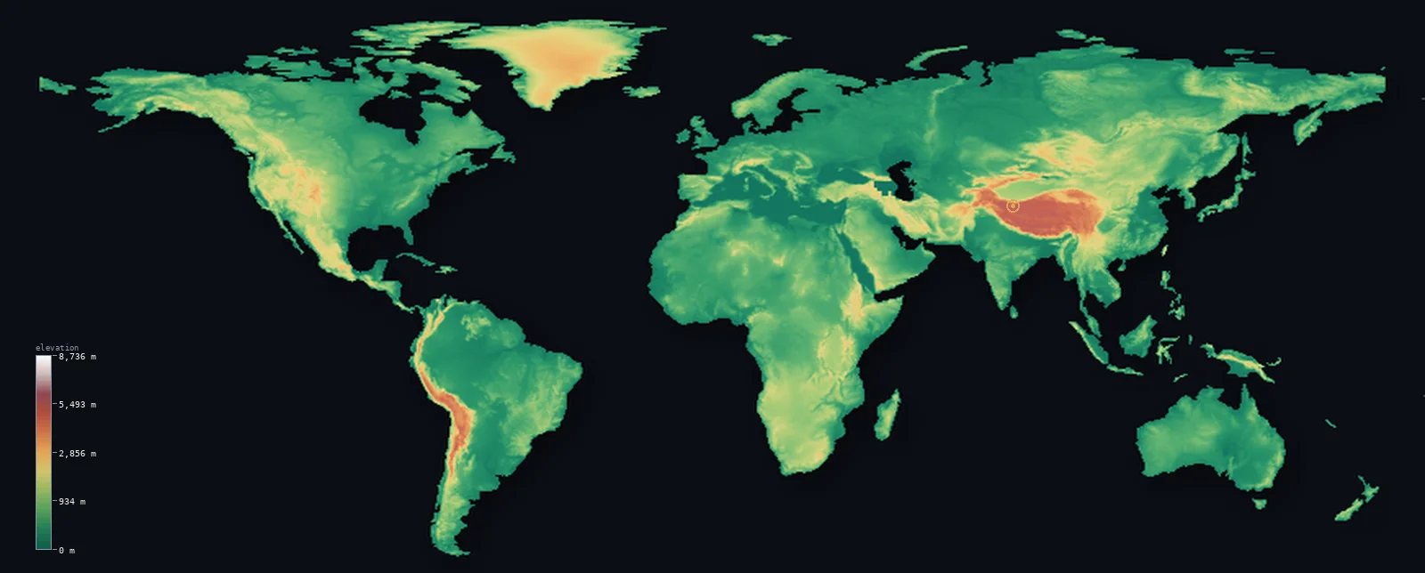
World’s highest point is Mount Everest at 29,032 ft (8,849 m); its lowest is Dead Sea shore at −1,444 ft (−440 m); the mean elevation is 2,628 ft (801 m).
- Highest point📚
- 29,032 ft8,849 m
- The highest point on Earth is Mount Everest at 29,032 ft (8,849 m), on the border of Nepal and China in the Himalaya - the summit of the planet, the highest that solid land rises above sea level anywhere. It stands at the crest of the Himalaya, the great mountain wall thrown up where the Indian subcontinent drives into Asia, among a cluster of the only peaks on Earth to exceed 8,000 m. No land rises higher.
- Lowest point📚
- −1,444 ft−440 m
- The lowest exposed land on Earth is the shore of the Dead Sea, at about 1,444 ft (440 m) below sea level, on the border of Israel and Jordan - the lowest that dry land descends anywhere on the planet, in the deep rift valley that runs from the Levant into East Africa, its hypersaline surface dropping lower year by year. (Far lower ground exists but is not exposed land: the floor of the Mariana Trench, in the Pacific, lies about 10,935 m below sea level - the deepest point of the Earth's solid surface - but beneath the ocean; and the bedrock of the Bentley Subglacial Trench in Antarctica sinks below sea level too, but buried under the ice.)
- Mean elevation⚙
- 2,628 ft801 m
- Computed from the GLO-30 model, the mean elevation of the Earth's land is 2,628 ft (801 m) (a commonly-cited figure is around 2,756 ft / 840 m; the value here is computed directly from the elevation surface). But this average is misleading about the typical place: half of the Earth's land lies below about 1,398 ft (426 m). The great mountain ranges and high plateaus - the Himalaya and Tibet, the Andes, the Antarctic ice sheet - lift the average high, but they are a minority of the land; most of the planet's surface is low, in the vast plains, basins, and lowlands.
- Median elevation⚙
- 1,398 ft426 m
- Half of the Earth's land lies below about 1,398 ft (426 m) - far below the mean, and the single most telling fact about the planet's surface. For all the fame of the great mountains, most of the Earth's land is low: the vast lowland plains, the great river basins (the Amazon, the Congo, the plains of Siberia and North America), and the low continental shields make up the bulk of it. The high ground - the mountain belts and the high plateaus - is real, and dramatic, but it is the exception. Most of the world is low.
- Elevation range📚
- 30,476 ft9,289 m
- From the shore of the Dead Sea at 440 m below sea level to the summit of Mount Everest at 8,849 m, the exposed land of the Earth spans about 30,476 ft - from the lowest dry land on the planet to its highest point, the full vertical range of the world's terrain.
- Above 1,000 m (3,281 ft)⚙
- 26%
- About 26% of the Earth's land rises above 1,000 m (3,281 ft) - the great mountain systems (the Himalaya and the ranges of Asia, the Andes, the Rockies, the East African and Ethiopian highlands) and the high plateaus (Tibet, the Altiplano, the interior of Antarctica and Greenland). Nearly three-quarters of the land lies below.
- Above 2,000 m (6,562 ft)⚙
- 11%
- Roughly 11% of the Earth's land stands above 2,000 m (6,562 ft) - the highest country of the planet: the Tibetan Plateau and the Himalaya, the high Andes and the Altiplano, the Ethiopian Highlands, the interiors of the great ice sheets. A small fraction of the land, holding its highest and most extreme terrain.
- Official area📚
- 57,506,032 mi²148,940,000 km²
- The Earth's land covers about 57,506,032 sq mi (148,940,000 sq km) - less than a third of the planet's surface, for oceans cover the rest. This land ranges from the great mountain belts and high plateaus, through the vast lowland plains, river basins, and continental shields that make up most of it, to the ice sheets of Antarctica and Greenland, dropping to the Dead Sea, the lowest exposed land on Earth.
- Forest cover📚
- 31%
- About 31% of the Earth's land is forested - from the vast boreal forests ringing the far north, through the temperate forests of the mid-latitudes, to the great tropical rainforests of the Amazon, the Congo, and Southeast Asia, alongside the grasslands, the great deserts, and the ice sheets and tundra of the poles.
World at a glance
Measured from base to summit rather than sea level, Mauna Kea in Hawaii is taller than Everest, rising over 10,000 m from the ocean floor.
source ↗The lowest point on Earth's solid surface is not on land but the Challenger Deep in the Mariana Trench, about 10,935 m below sea level.
source ↗The Dead Sea shore, the lowest dry land on Earth, drops about a metre lower every year as the sea recedes.
source ↗Because Earth bulges at the equator, the summit of Chimborazo in Ecuador - not Everest - is the point farthest from the planet's centre.
source ↗About 71% of Earth's surface is ocean, so this land-elevation map covers less than a third of the planet.
source ↗
Elevation profile of the World
The largest share of land, 55%, falls in the 0–500 m band, and 55% of the territory lies below 500 m (1,640 ft).
- below 500 m (1,640 ft)55%
- 500–1,000 m19%
- 1,000–2,000 m15%
- above 2,000 m (6,562 ft)11%
Highest and lowest points
The highest point on Earth's land surface, Mount Everest, 8,849 m, on the border between Nepal and the Tibet Autonomous Region of China in the Himalayas. Its height was fixed at 8,848.86 m by a joint China-Nepal survey in 2020. Measured from base to summit rather than from sea level, however, Mauna Kea in Hawaii is taller, and Chimborazo in Ecuador reaches farthest from Earth's centre.
source ↗The lowest exposed land on Earth is the shore of the Dead Sea, on the border of Israel and Jordan, about 440 m below sea level - the deepest that dry land descends anywhere, in the great rift valley that runs from the Levant into East Africa, its hypersaline surface dropping lower year by year. Far lower ground exists, but it is not exposed land: the floor of the Mariana Trench in the Pacific reaches about 10,935 m below sea level - the deepest point of the Earth's solid surface - but beneath the ocean; and the bedrock of Antarctica's Bentley Subglacial Trench sinks below sea level too, but buried under the ice. On this map of the land surface, the Dead Sea shore is the lowest point.
source ↗Highest peaks of the World
| Peak | Elevation | Range | Note |
|---|---|---|---|
| Mount Everest↗ | 29,032 ft8,849 m | Himalayas (Asia) | The highest point on Earth's land surface, on the Nepal-China border. |
| Aconcagua↗ | 22,838 ft6,961 m | Andes (South America) | The highest mountain outside Asia, and the highest in the Americas. |
| Denali↗ | 20,308 ft6,190 m | Alaska Range (North America) | The highest peak in North America. |
| Kilimanjaro↗ | 19,341 ft5,895 m | East African highlands (Africa) | The highest peak in Africa and the tallest free-standing mountain on Earth. |
| Mount Elbrus↗ | 18,510 ft5,642 m | Caucasus (Europe) | The highest peak in Europe, a dormant volcano in the Caucasus. |
Terrain regions of the World
Measured from base to summit rather than sea level, Mauna Kea in Hawaii is taller than Everest, rising over 10,000 m from the ocean floor. ↗
The great mountain belts
↗The two vast systems of high mountains - the Alpide belt from the Alps through the Himalaya, and the circum-Pacific ranges including the Andes and Rockies - hold nearly all the planet's highest ground.
The high plateaus
↗The elevated tablelands - Tibet, the Altiplano of the Andes, the East African and Ethiopian highlands - which lift huge areas of land far above sea level.
The lowlands and rift valleys
↗The great plains, basins and river lowlands, and the deep continental rifts like the Jordan and East African rifts, which hold the lowest dry land on Earth.
The great mountain belts
the collision zonesAlmost all of Earth's highest land lies in two enormous mountain systems built where tectonic plates collide. The Alpide belt runs from the Atlas and the Alps eastward through Anatolia and Iran to the Himalaya, where the collision of India with Asia has raised Everest (8,849 m) and every other peak above 8,000 m. The circum-Pacific belt rings the Pacific Ocean, carrying the Andes down the length of South America to Aconcagua, and the Rockies and Alaska Range with Denali through North America.
The high plateaus and shields
the continental interiorsBeyond the young mountain chains, broad areas of land ride high as plateaus. The Tibetan Plateau, the Roof of the World, averages about 4,000 m over an area the size of Western Europe; the Altiplano of the central Andes and the Ethiopian and East African highlands lift whole regions far above the sea. Elsewhere the ancient, worn shields of the continents - the Canadian, Baltic, African and Australian shields - form vast, stable, low-to-moderate expanses of the oldest rock on the planet.
The lowlands, plains and rifts
the inhabited lowlandsMost people live on the world's lowlands - the great river plains of the Ganges, Yangtze, Mississippi and Amazon, the coastal plains, and the structural basins between the highlands. In a few places the continental crust is actively pulling apart, dropping the land below sea level: the Jordan Rift Valley holds the Dead Sea shore at about 440 m below the sea, the lowest exposed land on Earth, and the East African Rift and the Turfan and Caspian depressions form other great below-sea-level troughs.
City elevations in the World
| City | Population | Elevation |
|---|---|---|
| Shanghai | 24,874,500 | 16 ft5 m |
| Beijingcapital | 18,960,744 | 154 ft47 m |
| Shenzhen | 17,494,398 | 33 ft10 m |
| Kinshasacapital | 16,000,000 | 928 ft283 m |
| Lagos | 15,388,000 | 26 ft8 m |
| Ho Chi Minh City | 14,002,598 | 23 ft7 m |
| Chengdu | 13,568,357 | 1,640 ft500 m |
| Lahore | 13,004,135 | 722 ft220 m |
| Mumbai | 12,691,836 | 26 ft8 m |
| São Paulo | 12,400,232 | 2,493 ft760 m |
Elevation sampled at each city centre from the Copernicus GLO-30 model. Cities and population from GeoNames (CC-BY 4.0).
World in comparison
World's terrain rises 30,476 ft (9,289 m) — from Dead Sea shore, 1,444 ft (440 m) below sea level to the summit of Mount Everest itself, the highest point on Earth.
- Asia's mean elevation is 2,631 ft — 3 ft higher; its high point, Mount Everest, reaches 29,032 ft (8,849 m), 0 ft above. Asia elevation map →
- Africa's mean elevation is 2,054 ft — 574 ft lower; its high point, Mount Kilimanjaro, reaches 19,341 ft (5,895 m), 9,692 ft below. Africa elevation map →
- South America's mean elevation is 1,906 ft — 722 ft lower; its high point, Aconcagua, reaches 22,838 ft (6,961 m), 6,194 ft below. South America elevation map →
Frequently asked questions
What is the highest point on Earth?
- Mount Everest, 29,032 ft (8,849 m), on the Nepal-China border in the Himalaya - the highest that land rises above sea level anywhere on the planet.
What is the lowest point on Earth?
- The lowest exposed land is the shore of the Dead Sea, about 1,444 ft (440 m) below sea level. The lowest point of the solid surface overall is the floor of the Mariana Trench (about 10,935 m below sea level), but that lies beneath the ocean, not on land.
What is the average elevation of the Earth's land?
- Computed from the GLO-30 model, about 2,628 ft (801 m) (a commonly-cited figure is around 840 m). But half of the Earth's land lies below about 1,398 ft (426 m) - because the great mountains are a minority, and most of the planet's land is low.
Is most of the Earth's land high or low?
- Low. Despite the fame of the great mountain ranges, half of the Earth's land lies below about 1,398 ft (426 m). The mountain belts and high plateaus are a dramatic minority; the bulk of the planet's land is plains, basins, and low shields.
How much of the Earth is covered by this map?
- Less than a third - this is a map of the Earth's land, and oceans cover more than 70% of the planet's surface.
Is Everest the tallest mountain in the world?
- By height above sea level, yes. But measured from its base, Mauna Kea is taller, and Chimborazo's summit is the farthest point from Earth's centre.
Is this a topographic, relief, contour, or elevation map of the world?
- They describe the same thing - terrain height. This page renders Earth's actual land-elevation surface in interactive 3D (a relief or topographic view) and reports the statistics computed from it; a contour map shows the same data as lines of equal height.
About this map
The terrain is rendered from the Copernicus GLO-30 digital elevation model (ESA), masked to the NE-LAND boundary from geoBoundaries (naturalearth-110m). Elevation statistics are computed directly from the model; peak names and researched facts are sourced and cited. See the methodology for the full pipeline.
This map renders 146,859,859 km² across 64 landmasses of World. 63 smaller outlying parts — 503,159 km² in total — lie beyond the area shown here. Area statistics above count the full territory.
Because World covers 146,859,859 km², its 3D terrain surface is rendered at roughly 14.8 km per pixel rather than the model’s native 30 m — the full-resolution grid exceeds the render budget for an area this large. The high point and every elevation figure on this page are still measured at native 30 m resolution; only the rendered surface detail is coarsened.
Our area-weighted mean, computed from the Copernicus GLO-30 model, is 2,628 ft (801 m); the figure commonly cited elsewhere is 2,756 ft (840 m) (commonly cited mean land elevation). This is a map of all the land on Earth - which is less than a third of the planet's surface; oceans cover the rest. Its highest point is Mount Everest, 8,849 m, the summit of the world; its lowest exposed land is the shore of the Dead Sea, about 440 m below sea level. And its most telling fact is one of proportion: for all the fame of the great mountains, most of the Earth's land is low. The average is lifted by the high minority - the Himalaya and the Tibetan Plateau, the Andes, the ice sheets of Antarctica and Greenland - but the typical place is far lower: half of the Earth's land lies below about 1,398 ft (426 m). The great mountain belts are dramatic but small; the bulk of the planet's surface is the vast plains, the river basins, the low shields and lowlands. So the world, seen whole, is mostly low ground - with the highest mountains on Earth rising, in a few places, far above it. (This is the surface of the land only - the ocean floor, which holds the planet's true lowest points, is not shown.)
Surveyed national figures: official area · forest cover · high point.
Rendered from Copernicus GLO-30 (ESA, 2021 release), boundaries from geoBoundaries. Generated 2026-07-16.
The 7 continents
Zoom into any continent to see how its ranges connect across borders, then down to individual countries.