Oceania Elevation Map
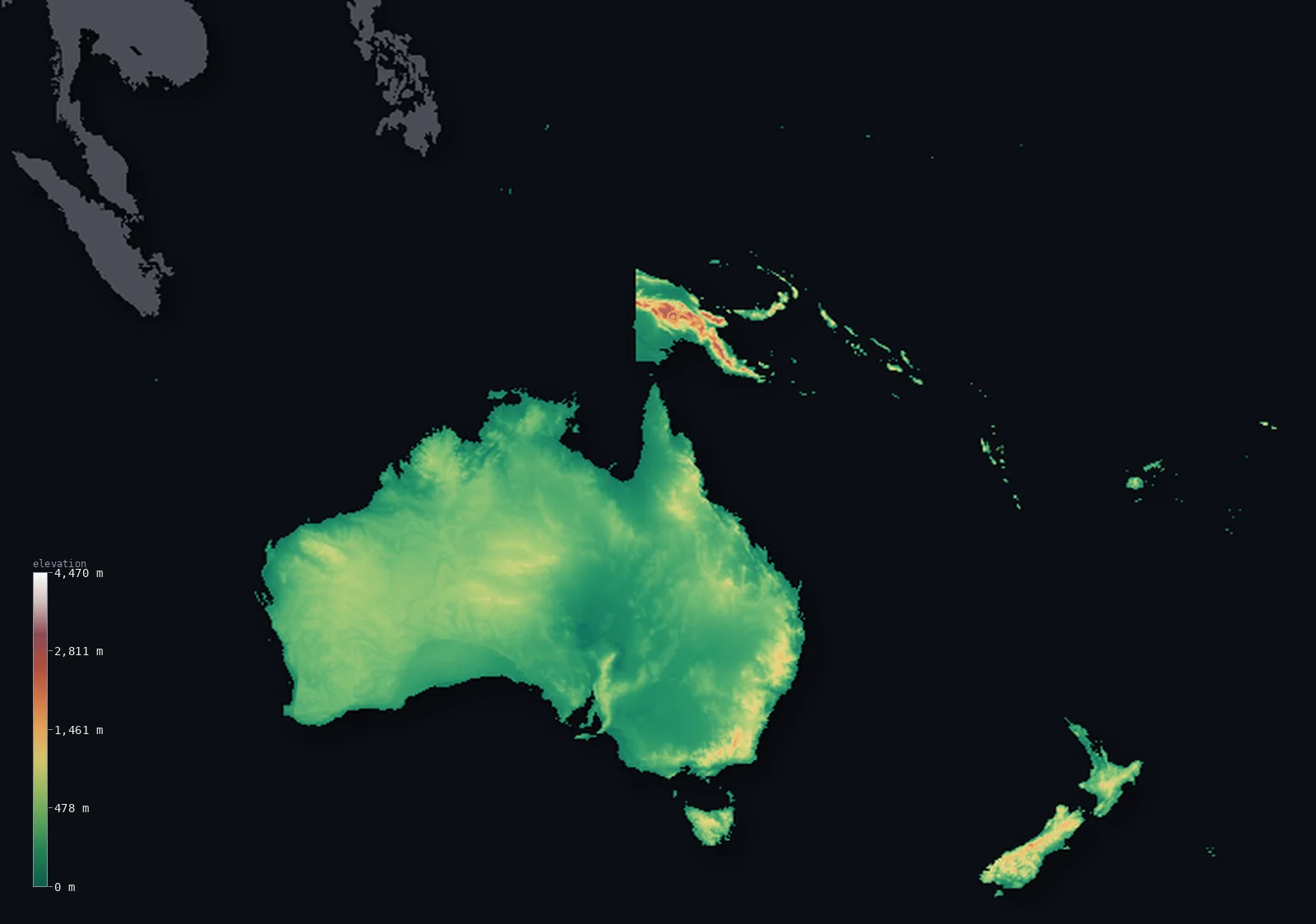
Oceania’s highest point is Mount Wilhelm at 14,793 ft (4,509 m); its lowest is Lake Eyre, Australia at −49 ft (−15 m); the mean elevation is 981 ft (299 m).
- Highest point📚
- 14,793 ft4,509 m
- Oceania's highest point, within the bounds of this map, is Mount Wilhelm at 14,793 ft (4,509 m), in the New Guinea Highlands of Papua New Guinea - the highest peak of the rugged central spine of New Guinea, on the Oceania side of the island. (Puncak Jaya, on the western, Indonesian half of New Guinea, is higher at 4,884 m, but because this map groups Indonesia with Asia, it lies beyond this view; Mount Wilhelm is the highest summit fully within Oceania.) It rises high above the surrounding lowlands, high enough for frost near its summit despite lying just south of the Equator.
- Lowest point📚
- −49 ft−15 m
- Oceania's lowest point is Lake Eyre (Kati Thanda) in South Australia, at about 49 ft (15 m) below sea level - a vast, usually-dry salt lake in the arid heart of the Australian outback, which fills with water only in rare wet years. It is the low center of the great flat Australian interior, from which the land rises gently to the low ranges and the coasts.
- Mean elevation⚙
- 981 ft299 m
- Computed from the GLO-30 model, Oceania's mean elevation is 981 ft (299 m) - the lowest of any continent, for Oceania is dominated by Australia, one of the flattest and lowest landmasses on Earth. The median is nearly as low: half the continent lies below about 804 ft (245 m). The vast, flat, arid Australian interior is the overwhelming body of the region; only the high, rugged island of New Guinea and the mountains of New Zealand rise high, and they are too small a part to lift the low average far.
- Median elevation⚙
- 804 ft245 m
- Half of Oceania lies below about 804 ft (245 m) - close to the mean, because Oceania is uniformly low. Australia, which makes up the great majority of the continent's land, is a low, flat, ancient landmass, worn down over eons to one of the flattest surfaces on Earth. The high ground - the rugged central spine of New Guinea (holding Mount Wilhelm), the Southern Alps of New Zealand, the volcanic Pacific islands - is real but a small minority of the area, so the typical point stays low, near the average.
- Elevation range📚
- 14,843 ft4,524 m
- From Lake Eyre at 15 m below sea level to the summit of Mount Wilhelm at 4,509 m, the terrain on this map of Oceania spans about 14,843 ft - from the dry salt heart of the Australian outback up to the frost-touched peaks of the New Guinea Highlands. (Higher ground still, Puncak Jaya on the Indonesian side of New Guinea, lies beyond the map's edge, in the part grouped with Asia.)
- Above 1,000 m (3,281 ft)⚙
- 2%
- About 2% of Oceania rises above 1,000 m (3,281 ft) - chiefly the rugged highlands of New Guinea, the Southern Alps of New Zealand, and the higher volcanic islands and the eastern Australian ranges. The vast flat Australian interior and the low coasts and islands lie well below.
- Official area📚
- 3,291,901 mi²8,525,989 km²
- Oceania, on this map (grouping Indonesia with Asia), covers about 3,291,901 sq mi (8,525,989 sq km) - the smallest continent, dominated by the vast low landmass of Australia, with the high, rugged island of New Guinea to the north (holding Mount Wilhelm), the mountainous islands of New Zealand to the southeast, and the scattered volcanic islands and coral atolls of the Pacific. Australia's flat, arid interior, dropping to Lake Eyre, is the low heart of the region.
Oceania at a glance
Australia is the flattest and lowest of the inhabited continents, with an average elevation of only about 330 m - its ancient interior has eroded nearly flat over hundreds of millions of years.
source ↗The island of New Guinea holds the tallest island mountains on Earth, rising from tropical lowlands to glaciated peaks above 4,500 m almost on the equator.
source ↗New Zealand's Southern Alps are rising about 7 mm a year as the Pacific and Australian plates collide, fast enough that erosion barely keeps pace.
source ↗Several Pacific nations - Tuvalu, the Marshall Islands, Kiribati - have highest points only a few metres above sea level, among the lowest-lying countries on Earth.
source ↗Australia's mainland has no permanent snow-capped mountains, while New Guinea just to its north carries equatorial glaciers on its highest peaks.
source ↗
Elevation profile of Oceania
The largest share of land, 51%, falls in the 0–250 m band, and 87% of the territory lies below 500 m (1,640 ft).
- below 500 m (1,640 ft)87%
- 500–1,000 m11%
- 1,000–2,000 m2%
- above 2,000 m (6,562 ft)<1%
Highest and lowest points
The highest point of a sovereign Oceanian state is Mount Wilhelm, 4,509 m, in Papua New Guinea's Bismarck Range. The New Guinea landmass reaches 4,884 m at Puncak Jaya on the Indonesian side, but that is counted under Asia; Wilhelm is the highest summit fully within Oceania and the point this map anchors.
source ↗Lake Eyre (Kati Thanda) in South Australia, about 15 m below sea level - a salt-pan basin that rarely fills, the lowest natural land in Oceania.
source ↗Highest peaks of Oceania
| Peak | Elevation | Range | Note |
|---|---|---|---|
| Mount Wilhelm↗ | 14,793 ft4,509 m | Bismarck Range (Papua New Guinea) | Highest point of Papua New Guinea and of sovereign Oceania. |
| Mount Giluwe↗ | 14,327 ft4,367 m | Papua New Guinea | The highest volcano in Oceania. |
| Mount Victoria↗ | 13,248 ft4,038 m | Owen Stanley Range (Papua New Guinea) | The high point of the Owen Stanley Range, in southeastern Papua New Guinea. |
| Aoraki / Mount Cook↗ | 12,218 ft3,724 m | Southern Alps (New Zealand) | The highest point of New Zealand. |
| Mount Kosciuszko↗ | 7,310 ft2,228 m | Snowy Mountains (Australia) | The highest point of mainland Australia. |
Terrain regions of Oceania
Australia is the flattest and lowest of the inhabited continents, with an average elevation of only about 330 m - its ancient interior has eroded nearly flat over hundreds of millions of years. ↗
The Australian landmass
~86% (Australia is the great bulk of Oceania's land)Australia dominates Oceania - a vast, flat, arid continent whose worn interior averages only about 330 m. Its highest ground, the Snowy Mountains with Mount Kosciuszko (2,228 m), sits in the southeast; the dry centre holds Lake Eyre, 15 m below sea level.
New Guinea and Melanesia
~11% (New Guinea + the Melanesian arc)North of Australia, the island of New Guinea rises to the highest terrain in Oceania - Mount Wilhelm (4,509 m) in Papua New Guinea, with equatorial glaciers on the loftiest peaks. The Melanesian arc continues through the Solomon Islands, Vanuatu and Fiji, volcanic and mountainous.
New Zealand and the Pacific islands
~3% (New Zealand + the scattered Pacific islands)New Zealand's Southern Alps, crowned by Aoraki / Mount Cook (3,724 m), are sharp and glaciated, still rising as two plates collide. Scattered across the Pacific, the islands of Micronesia and Polynesia range from high volcanic peaks to low coral atolls only metres above the sea.
City elevations in Oceania
| City | Population | Elevation |
|---|---|---|
| Sydney | 5,638,830 | 184 ft56 m |
| Brisbane | 5,638,830 | 89 ft27 m |
| Melbourne | 5,435,590 | 85 ft26 m |
| Perth | 2,384,371 | 62 ft19 m |
| Adelaide | 1,469,163 | 157 ft48 m |
| Canberracapital | 367,752 | 1,860 ft567 m |
| Port Moresbycapital | 283,733 | 59 ft18 m |
| Hobart | 254,930 | 59 ft18 m |
| Townsville | 201,313 | 43 ft13 m |
| Cairns | 153,075 | 16 ft5 m |
Elevation sampled at each city centre from the Copernicus GLO-30 model. Cities and population from GeoNames (CC-BY 4.0).
Oceania in comparison
Oceania's terrain rises 14,843 ft (4,524 m) from Lake Eyre, Australia, 49 ft (15 m) below sea level to Mount Wilhelm — about 51% of the height of Mount Everest, the world's highest point at 29,032 ft (8,849 m).
- World's mean elevation is 2,628 ft — 1,647 ft higher; its high point, Mount Everest, reaches 29,032 ft (8,849 m), 14,239 ft above. World elevation map →
- Asia's mean elevation is 2,631 ft — 1,650 ft higher; its high point, Mount Everest, reaches 29,032 ft (8,849 m), 14,239 ft above. Asia elevation map →
- South America's mean elevation is 1,906 ft — 925 ft higher; its high point, Aconcagua, reaches 22,838 ft (6,961 m), 8,045 ft above. South America elevation map →
Frequently asked questions
What is the highest point in Oceania?
- Within this map, Mount Wilhelm, 14,793 ft (4,509 m), in Papua New Guinea - the highest summit fully within Oceania. (Puncak Jaya, 4,884 m, on the Indonesian side of New Guinea, is higher but lies in the part grouped with Asia.)
What is the lowest point in Oceania?
- Lake Eyre (Kati Thanda) in South Australia, about 49 ft (15 m) below sea level - a usually-dry salt lake in the arid Australian interior.
What is the average elevation of Oceania?
- Computed from the GLO-30 model, about 981 ft (299 m) - the lowest of any continent, because Oceania is dominated by Australia, one of the flattest landmasses on Earth. Half the continent lies below about 804 ft (245 m).
Why is Oceania the lowest continent?
- Because it is dominated by Australia, a vast, flat, ancient landmass - one of the flattest and lowest on Earth. The high ground (New Guinea, New Zealand) is a small minority of the area, too little to lift the low Australian average.
Why is Australia so flat?
- Australia is the oldest and most eroded continental landmass, with no recent major mountain-building; its interior has worn down over hundreds of millions of years to an average of only about 330 m.
Is Hawaii part of Oceania on this map?
- Geographically Hawaii is part of Polynesia, but as a US state it is rendered under North America, so it does not appear in this Oceania frame.
What are the lowest-lying countries in Oceania?
- Tuvalu, the Marshall Islands and Kiribati - coral-atoll nations whose highest points are only a few metres above sea level, among the lowest countries on Earth.
Is this a topographic, relief, or elevation map of Oceania?
- They describe the same thing - terrain height. This page renders Oceania's actual elevation surface in interactive 3D and reports the statistics computed from it.
About this map
The terrain is rendered from the Copernicus GLO-30 digital elevation model (ESA), masked to the CONTINENT-OCEANIA boundary from geoBoundaries (gbOpen). Elevation statistics are computed directly from the model; peak names and researched facts are sourced and cited. See the methodology for the full pipeline.
Because Oceania covers 8,481,132 km², its 3D terrain surface is rendered at roughly 4.4 km per pixel rather than the model’s native 30 m — the full-resolution grid exceeds the render budget for an area this large. The high point and every elevation figure on this page are still measured at native 30 m resolution; only the rendered surface detail is coarsened.
Our area-weighted mean, computed from the Copernicus GLO-30 model, is 981 ft (299 m); no authority publishes a mean elevation (no single authoritative continental mean). Oceania is the lowest and flattest continent, and the reason is Australia. Australia makes up the great majority of the region's land, and it is one of the flattest, lowest, most ancient landmasses on Earth - a vast worn shield of arid interior, its center dropping below sea level at Lake Eyre. So Oceania's mean elevation, 981 ft (299 m), is the lowest of any continent, and its median, 804 ft (245 m), is nearly as low - the sign of a land that is low throughout, not one where mountains lift a low average. The high ground is real but small: the rugged central spine of New Guinea, rising to Mount Wilhelm (the highest point on this map), the Southern Alps of New Zealand, the volcanic peaks of the Pacific islands. But these are a minority of the area, too small to lift the low Australian average far. (Higher than Mount Wilhelm, Puncak Jaya stands on the Indonesian half of New Guinea, beyond this map's edge, in the part grouped with Asia. No single authoritative figure for the mean elevation of a whole continent is published; the value here is computed directly from the GLO-30 elevation surface.)
Surveyed national figures: official area · high point.
Rendered from Copernicus GLO-30 (ESA, 2021 release), boundaries from geoBoundaries. Generated 2026-07-20.
Countries in Oceania · 13
Every country in Oceania on the same elevation scale — open any one for its full 3D map and statistics.