Micronesia Elevation Map
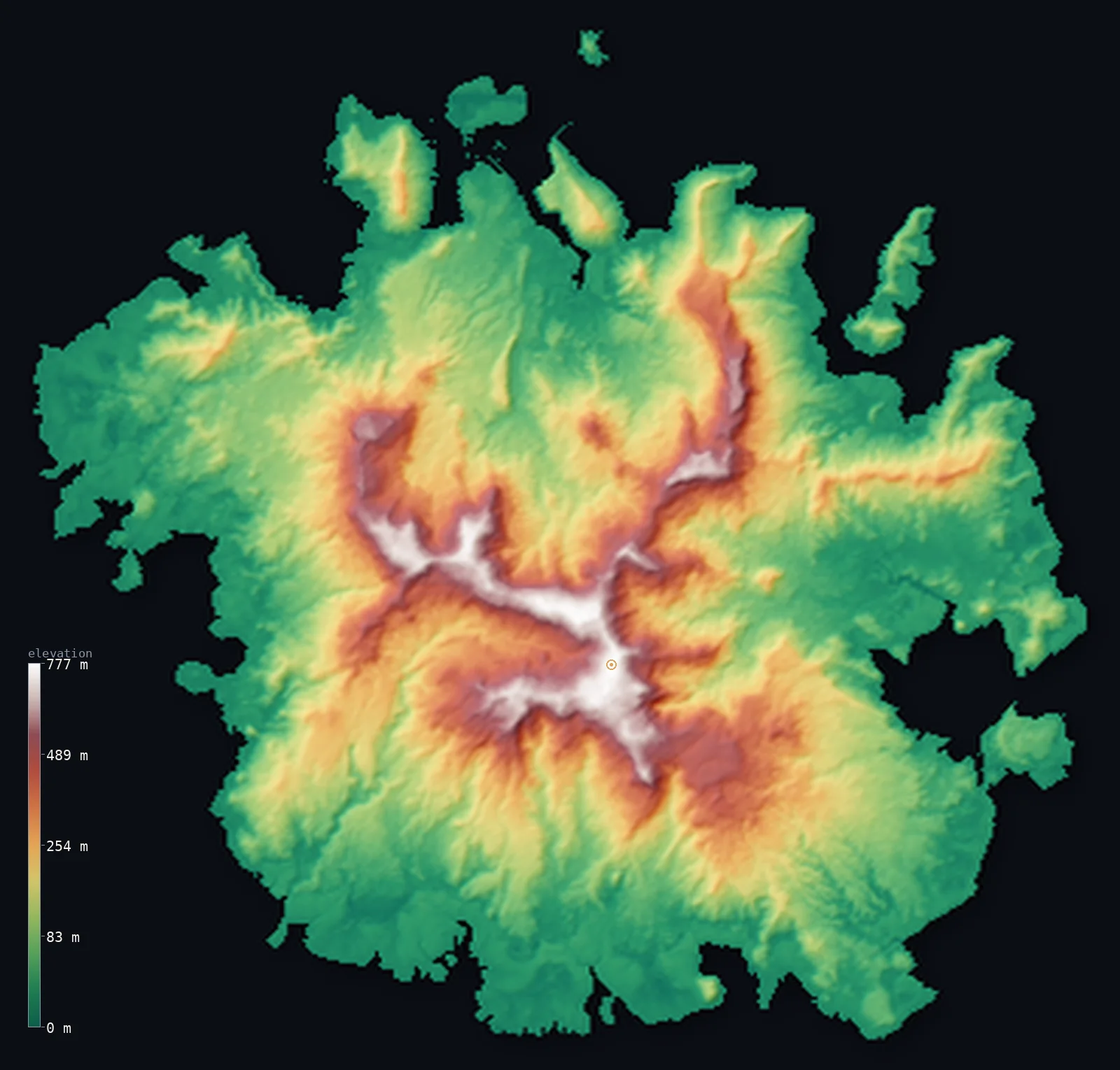
Micronesia’s highest point is Mount Nanlaud at 2,566 ft (782 m); its lowest is Pacific Ocean at 0 ft (0 m); the mean elevation is 499 ft (152 m).
- Highest point📚
- 2,566 ft782 m
- Mount Nanlaud, on the volcanic island of Pohnpei.
- Lowest point📚
- 0 ft0 m
- Sea level - the Pacific surrounds every island.
- Mean elevation⚙
- 499 ft152 m
- Computed from the GLO-30 surface model over the islands.
- Median elevation⚙
- 289 ft88 m
- Half of Micronesia lies below this height.
- Elevation range📚
- 2,566 ft782 m
- From the sea to Mount Nanlaud's 782 m.
- Official area📚
- 271 mi²702 km²
- A vast, dispersed island nation in the west Pacific.
- Forest cover📚
- 91.9%
- Heavily forested - dense rainforest on the high islands.
Highest and lowest points
The highest point of the Federated States of Micronesia at 782 m - Mount Nanlaud (Nahnalaud), in the south of Pohnpei, the country's largest and highest island (per the definitive USGS 1:25,000 survey). It is sometimes confused with the nearby lower peaks Ngihneni and Dolohmwar (Totolom, 760 m). It is interior; as an island nation FSM has no land borders.
source ↗Mount Nanlaud's surveyed summit sits just outside the generalized Micronesia boundary, so the highest fully in-territory land pixel in the model is 2,559 ft (780 m). The headline figure above is the surveyed elevation of the recognised national high point.
Micronesia at a glance
The FSM's 607 islands stretch about 2,700 km across the Pacific, yet their total land area is just 702 km2 - scattered across an ocean territory of nearly 3 million km2.
source ↗Mount Nanlaud on Pohnpei (782 m) is one of the wettest places on Earth, with around 10 m of rain a year.
source ↗Off southeastern Pohnpei lie the ruins of Nan Madol, a city of nearly 100 artificial islets built from columnar basalt around 1200 AD.
source ↗The country's islands range from steep volcanic peaks to coral atolls barely above the waves - both extremes of Pacific island form.
source ↗Chuuk Lagoon, ringed by a 55 km barrier reef, is one of the largest lagoons in the world and a famous WWII shipwreck dive site.
source ↗The four states - Yap, Chuuk, Pohnpei and Kosrae - are so far apart and distinct that the country spans two time zones.
source ↗
Elevation profile of Micronesia
The largest share of land, 38%, falls in the 0–50 m band, and 94% of the territory lies below 500 m (1,640 ft).
- below 500 m (1,640 ft)94%
- 500–1,000 m6%
Highest peaks of Micronesia
| Peak | Elevation | Range | Note |
|---|---|---|---|
| Mount Nanlaud↗ | 2,566 ft782 m | Pohnpei (east-central) | Highest point of the FSM, on the volcanic island of Pohnpei - one of the wettest places on Earth. |
| Mount Finkol↗ | 2,080 ft634 m | Kosrae (east) | The highest point of Kosrae, the easternmost state, a single eroded volcanic island. |
| Tol Island high point↗ | 1,453 ft443 m | Chuuk Lagoon (central) | The highest of the volcanic islands rising within the great Chuuk Lagoon. |
Terrain regions of Micronesia
The FSM's 607 islands stretch about 2,700 km across the Pacific, yet their total land area is just 702 km2 - scattered across an ocean territory of nearly 3 million km2. ↗
The high volcanic islands
↗Eroded volcanic islands with steep, forested relief - Pohnpei (highest, with Mount Nanlaud), Kosrae in the east, and the volcanic islands within Chuuk Lagoon.
The atolls and low islands
↗Scores of low coral atolls and reef islands - across Yap State in the west and the outer islands of Chuuk and Pohnpei - rarely more than a few metres above the sea.
The high islands
most of the land areaThe four state centres are mostly high islands - the eroded, deeply weathered remnants of old volcanoes with steep, rainforested interiors. Pohnpei is the largest and highest, rising to Mount Nanlaud (782 m); Kosrae in the far east is a single volcanic mass reaching about 634 m; and inside the huge Chuuk Lagoon, volcanic islands rise to around 443 m. These islands are ringed by fringing or barrier reefs.
The dispersed atolls
spread over ~3,000,000 km2 of seaAlongside the high islands are scores of low coral atolls - especially across Yap State in the west and the outer islands - rising only a metre or two above the sea. Altogether the FSM's 607 islands stretch about 2,700 km from west (Yap) to east (Kosrae) along the Caroline Islands arc, scattered across nearly 3 million km2 of ocean, though the total land area is only 702 km2.
City elevations in Micronesia
| City | Population | Elevation |
|---|---|---|
| PalikircapitalPalikir, the capital, sits on Pohnpei, the high volcanic island that holds the country's highest peak. ↗ | 6,942 | 279 ft85 m |
| Madolenihm Municipality Government | 0 | 256 ft78 m |
Elevation sampled at each city centre from the Copernicus GLO-30 model. Cities and population from GeoNames (CC-BY 4.0).
Micronesia in comparison
Micronesia's terrain rises 2,566 ft (782 m) from sea level to Mount Nanlaud — about 9% of the height of Mount Everest, the world's highest point at 29,032 ft (8,849 m).
- Marshall Islands's mean elevation is 2 ft — 496 ft lower; its high point, Likiep high point (unnamed), reaches 33 ft (10 m), 2,533 ft below. Marshall Islands elevation map →
- Palau's mean elevation is 56 ft — 443 ft lower; its high point, Mount Ngerchelchuus, reaches 794 ft (242 m), 1,772 ft below. Palau elevation map →
Frequently asked questions
What is the highest point in Micronesia (FSM)?
- Mount Nanlaud, 2,566 ft (782 m), on the volcanic island of Pohnpei - the country's largest and highest island.
What is the average elevation of the FSM?
- The FSM mixes high volcanic islands (up to 782 m) with low coral atolls, so a single mean means little. The figure here is computed from the Copernicus GLO-30 model over the islands.
What is the lowest point in the FSM?
- Sea level - the Pacific Ocean surrounds every island and atoll.
How spread out is the FSM?
- Its 607 islands stretch about 2,700 km from Yap in the west to Kosrae in the east, across nearly 3 million km2 of ocean, though the land totals only 702 km2.
What kinds of islands make up the FSM?
- Both high eroded volcanic islands - Pohnpei, Kosrae and the islands of Chuuk Lagoon - and low coral atolls, especially across Yap and the outer islands.
Is this a topographic, relief, contour, or elevation map of Micronesia?
- They describe the same thing - terrain height. This page renders the FSM's actual elevation surface in interactive 3D (a relief or topographic view) and reports the elevation statistics computed from it; a contour map shows the same data as lines of equal height.
About this map
The terrain is rendered from the Copernicus GLO-30 digital elevation model (ESA), masked to the FSM-ADM0 boundary from geoBoundaries (gbOpen). Elevation statistics are computed directly from the model; peak names and researched facts are sourced and cited. See the methodology for the full pipeline.
Our area-weighted mean, computed from the Copernicus GLO-30 model, is 499 ft (152 m); no authority publishes a mean elevation (no authoritative published mean). The FSM is a mix of high volcanic islands (rising to 782 m on Pohnpei) and low coral atolls barely above the sea, scattered across the Pacific, so a single mean is not very meaningful; the page reports the figure computed from the Copernicus GLO-30 model over the islands.
Surveyed national figures: official area · forest cover · high point.
Rendered from Copernicus GLO-30 (ESA, 2021 release), boundaries from geoBoundaries. Generated 2026-06-24.