Every country, in interactive 3D elevation.
Every country has a different shape of ground, and this page maps 194 of them in true 3D — each cut from the same Copernicus GLO-30 satellite model to its own borders, so Nepal’s Himalayan wall and the Dutch polders read on one scale.
Open any one and it renders as real terrain you can grab, tilt and spin, with the figures computed straight from the model — highest and lowest points, mean and median elevation. A colour map tells you a country has mountains; the 3D model shows how high they stand.
See it in 3D
Three countries, three kinds of terrain
Nepal’s Himalaya, the Andes running the length of Chile, and Norway’s glacier-carved fjord coast. Each map below is live — scroll to it and it loads in 3D; drag to spin it, and open the full page for its elevation profile.
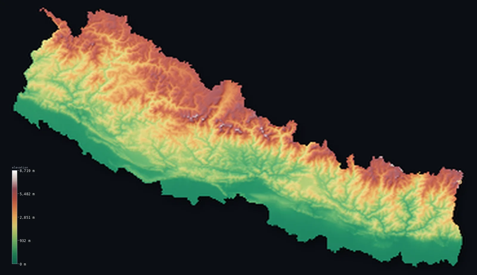
Highest point Mount Everest (Sagarmatha), 8,849 m

Highest point Ojos del Salado, 6,893 m
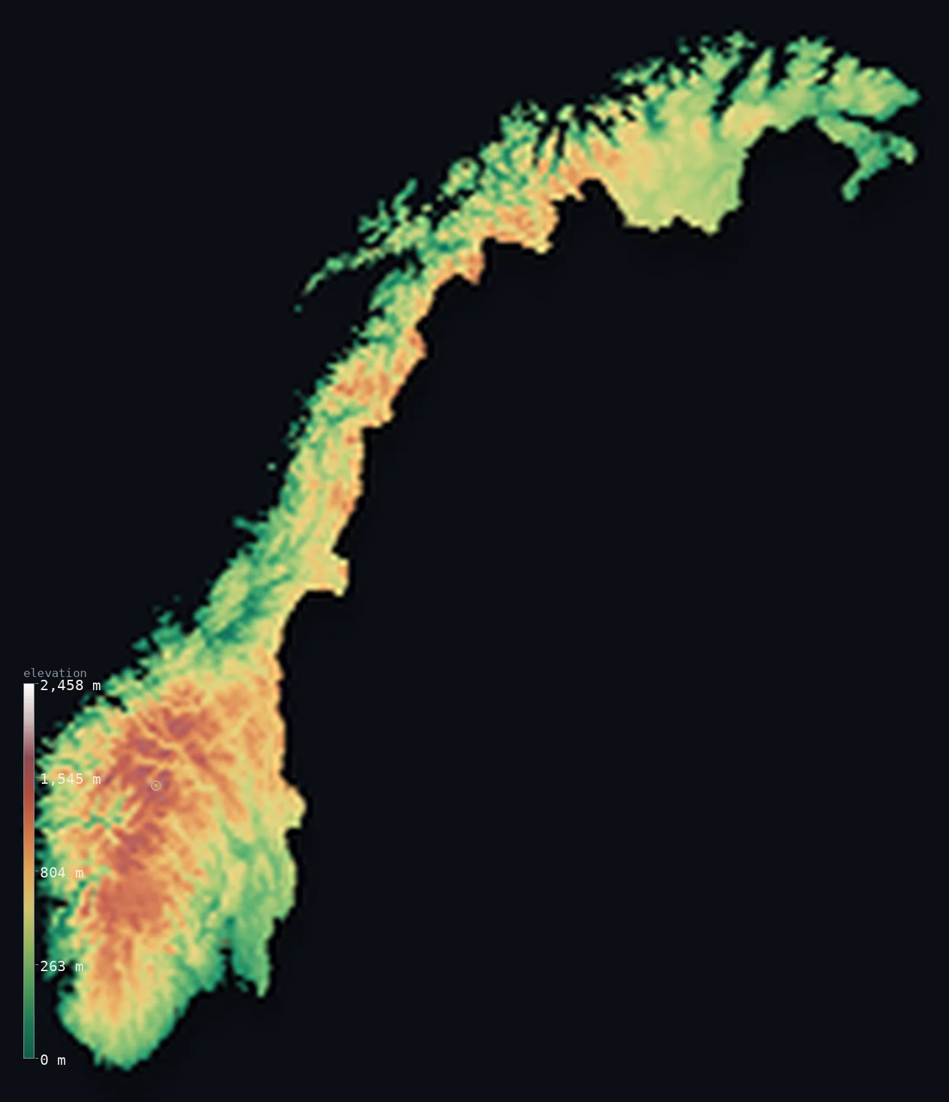
Highest point Galdhopiggen, 2,469 m
Browse
All 194 countries
Grouped by continent, alphabetical within each. Every card opens that country’s full 3D map and elevation statistics.
Africa · 54
- Algeria
Its land ranges 9,672 ft (2,948 m), from Chott Melrhir up to Mount Tahat. Its lowest ground, Chott Melrhir, lies below the sea, at −131 ft (−40 m).
- Highest
- Mount Tahat · 9,541 ft (2,908 m)
- Lowest
- Chott Melrhir · −131 ft (−40 m)
- Mean
- 1,827 ft (557 m)
- · Median
- 1,568 ft (478 m)
- Angola
Its land ranges 8,596 ft (2,620 m), from the Atlantic Ocean up to Mount Moco (Morro de Môco). Half its land lies below 3,698 ft (1,127 m).
- Highest
- Mount Moco (Morro de Môco) · 8,596 ft (2,620 m)
- Lowest
- Atlantic Ocean · sea level
- Mean
- 3,402 ft (1,037 m)
- · Median
- 3,698 ft (1,127 m)
- Benin
Its land ranges 2,159 ft (658 m), from the Atlantic Ocean (Bight of Benin) up to Mont Sokbaro. Half its land lies below 928 ft (283 m).
- Highest
- Mont Sokbaro · 2,159 ft (658 m)
- Lowest
- Atlantic Ocean (Bight of Benin) · sea level
- Mean
- 873 ft (266 m)
- · Median
- 928 ft (283 m)
- Botswana
Its land ranges 3,222 ft (982 m), from Junction of the Limpopo and Shashe Rivers up to Monalanong Hill. Half its land lies below 3,343 ft (1,019 m).
- Highest
- Monalanong Hill · 4,905 ft (1,495 m)
- Lowest
- Junction of the Limpopo and Shashe Rivers · 1,683 ft (513 m)
- Mean
- 3,383 ft (1,031 m)
- · Median
- 3,343 ft (1,019 m)
- Burkina Faso
Its land ranges 1,801 ft (549 m), from the Mouhoun (Black Volta) River up to Mount Tenakourou. Half its land lies below 965 ft (294 m).
- Highest
- Mount Tenakourou · 2,457 ft (749 m)
- Lowest
- Mouhoun (Black Volta) River · 656 ft (200 m)
- Mean
- 978 ft (298 m)
- · Median
- 965 ft (294 m)
- Burundi
A high country — half its land lies above 5,164 ft (1,574 m), rising to Mount Heha. Its mean elevation is 5,125 ft (1,562 m).
- Highest
- Mount Heha · 8,806 ft (2,684 m)
- Lowest
- Lake Tanganyika · 2,533 ft (772 m)
- Mean
- 5,125 ft (1,562 m)
- · Median
- 5,164 ft (1,574 m)
- Cabo Verde
Its land ranges 9,281 ft (2,829 m), from the Atlantic Ocean up to Pico do Fogo. Half its land lies below 522 ft (159 m).
- Highest
- Pico do Fogo · 9,281 ft (2,829 m)
- Lowest
- Atlantic Ocean · sea level
- Mean
- 1,060 ft (323 m)
- · Median
- 522 ft (159 m)
- Cameroon
A dramatic 13,435 ft (4,095 m) of relief separates the Atlantic Ocean from Fako (Mount Cameroon). Half its land lies below 2,116 ft (645 m).
- Highest
- Fako (Mount Cameroon) · 13,435 ft (4,095 m)
- Lowest
- Atlantic Ocean · sea level
- Mean
- 2,126 ft (648 m)
- · Median
- 2,116 ft (645 m)
- Central African Republic
Its land ranges 3,527 ft (1,075 m), from the Ubangi (Oubangui) River up to Mont Ngaoui. Half its land lies below 1,926 ft (587 m).
- Highest
- Mont Ngaoui · 4,626 ft (1,410 m)
- Lowest
- Ubangi (Oubangui) River · 1,099 ft (335 m)
- Mean
- 1,962 ft (598 m)
- · Median
- 1,926 ft (587 m)
- Chad
Its land ranges 10,679 ft (3,255 m), from the Djourab Depression up to Emi Koussi. Half its land lies below 1,375 ft (419 m).
- Highest
- Emi Koussi · 11,204 ft (3,415 m)
- Lowest
- Djourab Depression · 525 ft (160 m)
- Mean
- 1,696 ft (517 m)
- · Median
- 1,375 ft (419 m)
- Comoros
Its land ranges 7,746 ft (2,361 m), from the Indian Ocean up to Mount Karthala. Half its land lies below 1,270 ft (387 m).
- Highest
- Mount Karthala · 7,746 ft (2,361 m)
- Lowest
- Indian Ocean · sea level
- Mean
- 1,617 ft (493 m)
- · Median
- 1,270 ft (387 m)
- Côte d'Ivoire
Its land ranges 5,748 ft (1,752 m), from the Gulf of Guinea (Atlantic Ocean) up to Mont Nimba (Mount Richard-Molard). Half its land lies below 840 ft (256 m).
- Highest
- Mont Nimba (Mount Richard-Molard) · 5,748 ft (1,752 m)
- Lowest
- Gulf of Guinea (Atlantic Ocean) · sea level
- Mean
- 853 ft (260 m)
- · Median
- 840 ft (256 m)
- Democratic Republic of the Congo
A dramatic 16,762 ft (5,109 m) of relief separates the Atlantic Ocean from Margherita Peak (Mount Stanley). Half its land lies below 1,919 ft (585 m).
- Highest
- Margherita Peak (Mount Stanley) · 16,762 ft (5,109 m)
- Lowest
- Atlantic Ocean · sea level
- Mean
- 2,244 ft (684 m)
- · Median
- 1,919 ft (585 m)
- Djibouti
Its land ranges 7,162 ft (2,183 m), from Lake Assal up to Mousa Ali. Its lowest ground, Lake Assal, lies below the sea, at −509 ft (−155 m).
- Highest
- Mousa Ali · 6,654 ft (2,028 m)
- Lowest
- Lake Assal · −509 ft (−155 m)
- Mean
- 1,467 ft (447 m)
- · Median
- 1,401 ft (427 m)
- Egypt
Its land ranges 9,062 ft (2,762 m), from the Qattara Depression up to Mount Catherine (Gebel Katherina). Its lowest ground, the Qattara Depression, lies below the sea, at −436 ft (−133 m).
- Highest
- Mount Catherine (Gebel Katherina) · 8,625 ft (2,629 m)
- Lowest
- Qattara Depression · −436 ft (−133 m)
- Mean
- 988 ft (301 m)
- · Median
- 846 ft (258 m)
- Equatorial Guinea
Its land ranges 9,879 ft (3,011 m), from the Atlantic Ocean up to Pico Basile. Half its land lies below 1,886 ft (575 m).
- Highest
- Pico Basile · 9,879 ft (3,011 m)
- Lowest
- Atlantic Ocean · sea level
- Mean
- 1,604 ft (489 m)
- · Median
- 1,886 ft (575 m)
- Eritrea
Its land ranges 10,148 ft (3,093 m), from the Danakil Depression (near Kulul / Kobar Sink) up to Emba Soira. Its lowest ground, the Danakil Depression (near Kulul / Kobar Sink), lies below the sea, at −246 ft (−75 m).
- Highest
- Emba Soira · 9,902 ft (3,018 m)
- Lowest
- Danakil Depression (near Kulul / Kobar Sink) · −246 ft (−75 m)
- Mean
- 2,507 ft (764 m)
- · Median
- 2,162 ft (659 m)
- Eswatini
Its land ranges 6,040 ft (1,841 m), from the Great Usutu River up to Emlembe. Half its land lies below 1,673 ft (510 m).
- Highest
- Emlembe · 6,109 ft (1,862 m)
- Lowest
- Great Usutu River · 69 ft (21 m)
- Mean
- 2,064 ft (629 m)
- · Median
- 1,673 ft (510 m)
- Ethiopia
A dramatic 15,338 ft (4,675 m) of relief separates the Danakil Depression (Afar) from Ras Dashen. Its lowest ground, the Danakil Depression (Afar), lies below the sea, at −410 ft (−125 m).
- Highest
- Ras Dashen · 14,928 ft (4,550 m)
- Lowest
- Danakil Depression (Afar) · −410 ft (−125 m)
- Mean
- 4,111 ft (1,253 m)
- · Median
- 3,750 ft (1,143 m)
- Gabon
Its land ranges 3,510 ft (1,070 m), from the Atlantic Ocean up to Mont Bengoue. Half its land lies below 1,421 ft (433 m).
- Highest
- Mont Bengoue · 3,510 ft (1,070 m)
- Lowest
- Atlantic Ocean · sea level
- Mean
- 1,243 ft (379 m)
- · Median
- 1,421 ft (433 m)
- Ghana
Its land ranges 2,953 ft (900 m), from the Gulf of Guinea (Atlantic Ocean) up to Leklata. Half its land lies below 528 ft (161 m).
- Highest
- Leklata · 2,953 ft (900 m)
- Lowest
- Gulf of Guinea (Atlantic Ocean) · sea level
- Mean
- 591 ft (180 m)
- · Median
- 528 ft (161 m)
- Guinea
Its land ranges 5,748 ft (1,752 m), from the Atlantic Ocean up to Mount Nimba (Mont Richard-Molard). Half its land lies below 1,417 ft (432 m).
- Highest
- Mount Nimba (Mont Richard-Molard) · 5,748 ft (1,752 m)
- Lowest
- Atlantic Ocean · sea level
- Mean
- 1,447 ft (441 m)
- · Median
- 1,417 ft (432 m)
- Guinea-Bissau
Nearly flat: Monte Torin stands just 860 ft (262 m) above the Atlantic Ocean. Its average elevation is just 114 ft (34.8 m).
- Highest
- Monte Torin · 860 ft (262 m)
- Lowest
- Atlantic Ocean · sea level
- Mean
- 114 ft (34.8 m)
- · Median
- 95 ft (28.9 m)
- Kenya
A dramatic 17,057 ft (5,199 m) of relief separates the Indian Ocean from Mount Kenya (Batian). Half its land lies below 1,919 ft (585 m).
- Highest
- Mount Kenya (Batian) · 17,057 ft (5,199 m)
- Lowest
- Indian Ocean · sea level
- Mean
- 2,575 ft (785 m)
- · Median
- 1,919 ft (585 m)
- Lesotho
A high country — half its land lies above 7,241 ft (2,207 m), rising to Thabana Ntlenyana. Its mean elevation is 7,260 ft (2,213 m).
- Highest
- Thabana Ntlenyana · 11,424 ft (3,482 m)
- Lowest
- Makhaleng-Orange (Senqu) river junction · 4,593 ft (1,400 m)
- Mean
- 7,260 ft (2,213 m)
- · Median
- 7,241 ft (2,207 m)
- Liberia
Its land ranges 4,747 ft (1,447 m), from the Atlantic Ocean up to Mount Wuteve. Half its land lies below 679 ft (207 m).
- Highest
- Mount Wuteve · 4,747 ft (1,447 m)
- Lowest
- Atlantic Ocean · sea level
- Mean
- 705 ft (215 m)
- · Median
- 679 ft (207 m)
- Libya
Its land ranges 7,592 ft (2,314 m), from Sabkhat Ghuzayyil up to Bikku Bitti (Bette Peak). Its lowest ground, Sabkhat Ghuzayyil, lies below the sea, at −154 ft (−47 m).
- Highest
- Bikku Bitti (Bette Peak) · 7,438 ft (2,267 m)
- Lowest
- Sabkhat Ghuzayyil · −154 ft (−47 m)
- Mean
- 1,368 ft (417 m)
- · Median
- 1,506 ft (459 m)
- Madagascar
Its land ranges 9,436 ft (2,876 m), from the Indian Ocean up to Maromokotro. Half its land lies below 1,401 ft (427 m).
- Highest
- Maromokotro · 9,436 ft (2,876 m)
- Lowest
- Indian Ocean · sea level
- Mean
- 1,778 ft (542 m)
- · Median
- 1,401 ft (427 m)
- Malawi
Its land ranges 9,728 ft (2,965 m), from the Shire River at the Mozambique border up to Sapitwa Peak (Mount Mulanje). Half its land lies below 3,383 ft (1,031 m).
- Highest
- Sapitwa Peak (Mount Mulanje) · 9,849 ft (3,002 m)
- Lowest
- Shire River at the Mozambique border · 121 ft (37 m)
- Mean
- 3,104 ft (946 m)
- · Median
- 3,383 ft (1,031 m)
- Mali
Its land ranges 3,714 ft (1,132 m), from the Senegal River up to Hombori Tondo. Half its land lies below 991 ft (302 m).
- Highest
- Hombori Tondo · 3,789 ft (1,155 m)
- Lowest
- Senegal River · 75 ft (23 m)
- Mean
- 1,043 ft (318 m)
- · Median
- 991 ft (302 m)
- Mauritania
Its land ranges 3,018 ft (920 m), from Sebkhet Te-n-Dghamcha up to Kediet ej Jill. Its lowest ground, Sebkhet Te-n-Dghamcha, lies below the sea, at −16 ft (−5 m).
- Highest
- Kediet ej Jill · 3,002 ft (915 m)
- Lowest
- Sebkhet Te-n-Dghamcha · −16 ft (−5 m)
- Mean
- 853 ft (260 m)
- · Median
- 951 ft (290 m)
- Mauritius
Its land ranges 2,717 ft (828 m), from the Indian Ocean up to Piton de la Petite Riviere Noire. Half its land lies below 528 ft (161 m).
- Highest
- Piton de la Petite Riviere Noire · 2,717 ft (828 m)
- Lowest
- Indian Ocean · sea level
- Mean
- 709 ft (216 m)
- · Median
- 528 ft (161 m)
- Morocco
A dramatic 13,852 ft (4,222 m) of relief separates Sebkha Tah from Jbel Toubkal. Its lowest ground, Sebkha Tah, lies below the sea, at −180 ft (−55 m).
- Highest
- Jbel Toubkal · 13,671 ft (4,167 m)
- Lowest
- Sebkha Tah · −180 ft (−55 m)
- Mean
- 2,060 ft (628 m)
- · Median
- 1,355 ft (413 m)
- Mozambique
Its land ranges 7,992 ft (2,436 m), from the Indian Ocean up to Monte Binga. Half its land lies below 965 ft (294 m).
- Highest
- Monte Binga · 7,992 ft (2,436 m)
- Lowest
- Indian Ocean · sea level
- Mean
- 1,161 ft (354 m)
- · Median
- 965 ft (294 m)
- Namibia
Its land ranges 8,442 ft (2,573 m), from the Atlantic Ocean up to Konigstein (Brandberg). Half its land lies below 3,747 ft (1,142 m).
- Highest
- Konigstein (Brandberg) · 8,442 ft (2,573 m)
- Lowest
- Atlantic Ocean · sea level
- Mean
- 3,573 ft (1,089 m)
- · Median
- 3,747 ft (1,142 m)
- Niger
Its land ranges 5,978 ft (1,822 m), from the Niger River up to Mont Idoukal-n-Taghes. Half its land lies below 1,424 ft (434 m).
- Highest
- Mont Idoukal-n-Taghes · 6,634 ft (2,022 m)
- Lowest
- Niger River · 656 ft (200 m)
- Mean
- 1,503 ft (458 m)
- · Median
- 1,424 ft (434 m)
- Nigeria
Its land ranges 7,936 ft (2,419 m), from the Atlantic Ocean (Gulf of Guinea) up to Chappal Waddi. Half its land lies below 994 ft (303 m).
- Highest
- Chappal Waddi · 7,936 ft (2,419 m)
- Lowest
- Atlantic Ocean (Gulf of Guinea) · sea level
- Mean
- 1,073 ft (327 m)
- · Median
- 994 ft (303 m)
- Republic of the Congo
Its land ranges 3,346 ft (1,020 m), from the Atlantic Ocean up to Mont Nabemba. Half its land lies below 1,309 ft (399 m).
- Highest
- Mont Nabemba · 3,346 ft (1,020 m)
- Lowest
- Atlantic Ocean · sea level
- Mean
- 1,371 ft (418 m)
- · Median
- 1,309 ft (399 m)
- Rwanda
A high country — half its land lies above 5,308 ft (1,618 m), rising to Mount Karisimbi. Its mean elevation is 5,610 ft (1,710 m).
- Highest
- Mount Karisimbi · 14,787 ft (4,507 m)
- Lowest
- Ruzizi River · 3,117 ft (950 m)
- Mean
- 5,610 ft (1,710 m)
- · Median
- 5,308 ft (1,618 m)
- Sao Tome and Principe
Its land ranges 6,640 ft (2,024 m), from the Atlantic Ocean up to Pico de Sao Tome. Half its land lies below 804 ft (245 m).
- Highest
- Pico de Sao Tome · 6,640 ft (2,024 m)
- Lowest
- Atlantic Ocean · sea level
- Mean
- 1,145 ft (349 m)
- · Median
- 804 ft (245 m)
- Senegal
Its land ranges 2,126 ft (648 m), from the Atlantic Ocean up to Unnamed point near Nepen Diakha. Half its land lies below 149 ft (45.4 m).
- Highest
- Unnamed point near Nepen Diakha · 2,126 ft (648 m)
- Lowest
- Atlantic Ocean · sea level
- Mean
- 165 ft (50.3 m)
- · Median
- 149 ft (45.4 m)
- Seychelles
Its land ranges 2,969 ft (905 m), from the Indian Ocean up to Morne Seychellois. Half its land lies below 505 ft (154 m).
- Highest
- Morne Seychellois · 2,969 ft (905 m)
- Lowest
- Indian Ocean · sea level
- Mean
- 659 ft (201 m)
- · Median
- 505 ft (154 m)
- Sierra Leone
Its land ranges 6,391 ft (1,948 m), from the Atlantic Ocean up to Loma Mansa (Bintumani). Half its land lies below 367 ft (112 m).
- Highest
- Loma Mansa (Bintumani) · 6,391 ft (1,948 m)
- Lowest
- Atlantic Ocean · sea level
- Mean
- 646 ft (197 m)
- · Median
- 367 ft (112 m)
- Somalia
Its land ranges 8,071 ft (2,460 m), from the Indian Ocean up to Mount Shimbiris. Half its land lies below 991 ft (302 m).
- Highest
- Mount Shimbiris · 8,071 ft (2,460 m)
- Lowest
- Indian Ocean · sea level
- Mean
- 1,375 ft (419 m)
- · Median
- 991 ft (302 m)
- South Africa
Its land ranges 11,319 ft (3,450 m), from Atlantic and Indian Oceans up to Mafadi. Half its land lies below 3,507 ft (1,069 m).
- Highest
- Mafadi · 11,319 ft (3,450 m)
- Lowest
- Atlantic and Indian Oceans · sea level
- Mean
- 3,383 ft (1,031 m)
- · Median
- 3,507 ft (1,069 m)
- South Sudan
Its land ranges 9,206 ft (2,806 m), from White Nile up to Mount Kinyeti. Half its land lies below 1,476 ft (450 m).
- Highest
- Mount Kinyeti · 10,456 ft (3,187 m)
- Lowest
- White Nile · 1,250 ft (381 m)
- Mean
- 1,686 ft (514 m)
- · Median
- 1,476 ft (450 m)
- Sudan
Its land ranges 9,980 ft (3,042 m), from the Red Sea up to Deriba Caldera (Jebel Marra). Half its land lies below 1,611 ft (491 m).
- Highest
- Deriba Caldera (Jebel Marra) · 9,980 ft (3,042 m)
- Lowest
- Red Sea · sea level
- Mean
- 1,736 ft (529 m)
- · Median
- 1,611 ft (491 m)
- Tanzania
A dramatic 19,341 ft (5,895 m) of relief separates the Indian Ocean from Kilimanjaro (Uhuru Peak). Half its land lies below 3,691 ft (1,125 m).
- Highest
- Kilimanjaro (Uhuru Peak) · 19,341 ft (5,895 m)
- Lowest
- Indian Ocean · sea level
- Mean
- 3,340 ft (1,018 m)
- · Median
- 3,691 ft (1,125 m)
- The Gambia
Nearly flat: Unnamed elevation (eastern Gambia) stands just 174 ft (53 m) above the Atlantic Ocean. Its average elevation is just 69 ft (21.1 m).
- Highest
- Unnamed elevation (eastern Gambia) · 174 ft (53 m)
- Lowest
- Atlantic Ocean · sea level
- Mean
- 69 ft (21.1 m)
- · Median
- 64 ft (19.4 m)
- Togo
Its land ranges 3,235 ft (986 m), from the Atlantic Ocean (Gulf of Guinea) up to Mont Agou. Half its land lies below 732 ft (223 m).
- Highest
- Mont Agou · 3,235 ft (986 m)
- Lowest
- Atlantic Ocean (Gulf of Guinea) · sea level
- Mean
- 850 ft (259 m)
- · Median
- 732 ft (223 m)
- Tunisia
Its land ranges 5,121 ft (1,561 m), from Chott el Gharsa up to Jebel ech Chambi. Its lowest ground, Chott el Gharsa, lies below the sea, at −56 ft (−17 m).
- Highest
- Jebel ech Chambi · 5,066 ft (1,544 m)
- Lowest
- Chott el Gharsa · −56 ft (−17 m)
- Mean
- 833 ft (254 m)
- · Median
- 673 ft (205 m)
- Uganda
A dramatic 14,747 ft (4,495 m) of relief separates Albert Nile from Margherita Peak (Mount Stanley). Half its land lies below 3,635 ft (1,108 m).
- Highest
- Margherita Peak (Mount Stanley) · 16,762 ft (5,109 m)
- Lowest
- Albert Nile · 2,014 ft (614 m)
- Mean
- 3,822 ft (1,165 m)
- · Median
- 3,635 ft (1,108 m)
- Zambia
Its land ranges 6,594 ft (2,010 m), from the Zambezi River up to Mafinga Central. Half its land lies below 3,757 ft (1,145 m).
- Highest
- Mafinga Central · 7,674 ft (2,339 m)
- Lowest
- Zambezi River · 1,079 ft (329 m)
- Mean
- 3,671 ft (1,119 m)
- · Median
- 3,757 ft (1,145 m)
- Zimbabwe
Its land ranges 7,972 ft (2,430 m), from Junction of the Runde and Save rivers up to Mount Nyangani. Half its land lies below 3,343 ft (1,019 m).
- Highest
- Mount Nyangani · 8,504 ft (2,592 m)
- Lowest
- Junction of the Runde and Save rivers · 531 ft (162 m)
- Mean
- 3,192 ft (973 m)
- · Median
- 3,343 ft (1,019 m)
Asia · 48
- Afghanistan
A dramatic 23,734 ft (7,234 m) of relief separates the Amu Darya river from Noshaq. Even its typical ground is high — half the country lies above 5,177 ft (1,578 m).
- Highest
- Noshaq · 24,580 ft (7,492 m)
- Lowest
- Amu Darya river · 846 ft (258 m)
- Mean
- 5,906 ft (1,800 m)
- · Median
- 5,177 ft (1,578 m)
- Armenia
A high country — half its land lies above 6,224 ft (1,897 m), rising to Mount Aragats. Its mean elevation is 6,070 ft (1,850 m).
- Highest
- Mount Aragats · 13,419 ft (4,090 m)
- Lowest
- Debed River valley · 1,312 ft (400 m)
- Mean
- 6,070 ft (1,850 m)
- · Median
- 6,224 ft (1,897 m)
- Azerbaijan
A dramatic 14,744 ft (4,494 m) of relief separates the Caspian Sea from Mount Bazardüzü. Its lowest ground, the Caspian Sea, lies below the sea, at −92 ft (−28 m).
- Highest
- Mount Bazardüzü · 14,652 ft (4,466 m)
- Lowest
- Caspian Sea · −92 ft (−28 m)
- Mean
- 2,169 ft (661 m)
- · Median
- 1,148 ft (350 m)
- Bahrain
Nearly flat: Jabal ad Dukhan (Mountain of Smoke) stands just 440 ft (134 m) above the Persian Gulf. Its average elevation is just 46 ft (14 m).
- Highest
- Jabal ad Dukhan (Mountain of Smoke) · 440 ft (134 m)
- Lowest
- Persian Gulf · sea level
- Mean
- 46 ft (14 m)
- · Median
- 23 ft (7 m)
- Bangladesh
Its land ranges 3,451 ft (1,052 m), from the Bay of Bengal up to Saka Haphong (Mowdok Mual). Half its land lies below 35 ft (10.7 m).
- Highest
- Saka Haphong (Mowdok Mual) · 3,451 ft (1,052 m)
- Lowest
- Bay of Bengal · sea level
- Mean
- 90 ft (27.4 m)
- · Median
- 35 ft (10.7 m)
- Bhutan
A dramatic 24,518 ft (7,473 m) of relief separates Drangme Chhu (river) from Gangkhar Puensum. Even its typical ground is high — half the country lies above 9,173 ft (2,796 m).
- Highest
- Gangkhar Puensum · 24,836 ft (7,570 m)
- Lowest
- Drangme Chhu (river) · 318 ft (97 m)
- Mean
- 9,354 ft (2,851 m)
- · Median
- 9,173 ft (2,796 m)
- Brunei
Its land ranges 6,070 ft (1,850 m), from the South China Sea up to Bukit Pagon. Half its land lies below 153 ft (46.6 m).
- Highest
- Bukit Pagon · 6,070 ft (1,850 m)
- Lowest
- South China Sea · sea level
- Mean
- 322 ft (98.1 m)
- · Median
- 153 ft (46.6 m)
- Cambodia
Its land ranges 5,938 ft (1,810 m), from the Gulf of Thailand up to Phnom Aural. Half its land lies below 223 ft (68 m).
- Highest
- Phnom Aural · 5,938 ft (1,810 m)
- Lowest
- Gulf of Thailand · sea level
- Mean
- 404 ft (123 m)
- · Median
- 223 ft (68 m)
- China
A dramatic 29,537 ft (9,003 m) of relief separates the Ayding Lake, Turpan Depression from Mount Everest (Qomolangma). Its lowest ground, the Ayding Lake, Turpan Depression, lies below the sea, at −505 ft (−154 m).
- Highest
- Mount Everest (Qomolangma) · 29,032 ft (8,849 m)
- Lowest
- Ayding Lake, Turpan Depression · −505 ft (−154 m)
- Mean
- 6,014 ft (1,833 m)
- · Median
- 3,825 ft (1,166 m)
- Cyprus
Its land ranges 6,404 ft (1,952 m), from the Mediterranean Sea up to Mount Olympus (Chionistra). Half its land lies below 682 ft (208 m).
- Highest
- Mount Olympus (Chionistra) · 6,404 ft (1,952 m)
- Lowest
- Mediterranean Sea · sea level
- Mean
- 994 ft (303 m)
- · Median
- 682 ft (208 m)
- Georgia
A dramatic 17,037 ft (5,193 m) of relief separates the Black Sea from Shkhara. Half its land lies below 3,743 ft (1,141 m).
- Highest
- Shkhara · 17,037 ft (5,193 m)
- Lowest
- Black Sea · sea level
- Mean
- 4,045 ft (1,233 m)
- · Median
- 3,743 ft (1,141 m)
- India
A dramatic 28,251 ft (8,611 m) of relief separates the Indian Ocean from K2 (Godwin-Austen). Most of it lies far lower, though — half the land sits below 1,017 ft (310 m).
- Highest
- K2 (Godwin-Austen) · 28,251 ft (8,611 m)
- Lowest
- Indian Ocean · sea level
- Mean
- 2,306 ft (703 m)
- · Median
- 1,017 ft (310 m)
- Indonesia
A dramatic 16,024 ft (4,884 m) of relief separates the Indian Ocean from Puncak Jaya (Carstensz Pyramid). Most of it lies far lower, though — half the land sits below 341 ft (104 m).
- Highest
- Puncak Jaya (Carstensz Pyramid) · 16,024 ft (4,884 m)
- Lowest
- Indian Ocean · sea level
- Mean
- 1,112 ft (339 m)
- · Median
- 341 ft (104 m)
- Iran
A dramatic 18,497 ft (5,638 m) of relief separates the Caspian Sea from Mount Damavand. Its lowest ground, the Caspian Sea, lies below the sea, at −92 ft (−28 m).
- Highest
- Mount Damavand · 18,406 ft (5,610 m)
- Lowest
- Caspian Sea · −92 ft (−28 m)
- Mean
- 4,101 ft (1,250 m)
- · Median
- 4,009 ft (1,222 m)
- Iraq
Its land ranges 11,847 ft (3,611 m), from the Persian Gulf up to Cheekha Dar. Half its land lies below 781 ft (238 m).
- Highest
- Cheekha Dar · 11,847 ft (3,611 m)
- Lowest
- Persian Gulf · sea level
- Mean
- 974 ft (297 m)
- · Median
- 781 ft (238 m)
- Israel
Its land ranges 5,374 ft (1,638 m), from the Dead Sea shore up to Mount Meron. Its lowest ground, the Dead Sea shore, lies below the sea, at −1,411 ft (−430 m).
- Highest
- Mount Meron · 3,963 ft (1,208 m)
- Lowest
- Dead Sea shore · −1,411 ft (−430 m)
- Mean
- 928 ft (283 m)
- · Median
- 856 ft (261 m)
- Japan
Its land ranges 12,402 ft (3,780 m), from Hachirōgata up to Mount Fuji (Fujisan). Its lowest ground, Hachirōgata, lies below the sea, at −13 ft (−4 m).
- Highest
- Mount Fuji (Fujisan) · 12,388 ft (3,776 m)
- Lowest
- Hachirōgata · −13 ft (−4 m)
- Mean
- 1,299 ft (396 m)
- · Median
- 928 ft (283 m)
- Jordan
Its land ranges 7,493 ft (2,284 m), from the Dead Sea shore up to Jabal Umm ad Dami. Its lowest ground, the Dead Sea shore, lies below the sea, at −1,411 ft (−430 m).
- Highest
- Jabal Umm ad Dami · 6,083 ft (1,854 m)
- Lowest
- Dead Sea shore · −1,411 ft (−430 m)
- Mean
- 2,520 ft (768 m)
- · Median
- 2,602 ft (793 m)
- Kazakhstan
A dramatic 23,432 ft (7,142 m) of relief separates the Karagiye Depression (Vpadina Kaundy) from Khan Tengri. Its lowest ground, the Karagiye Depression (Vpadina Kaundy), lies below the sea, at −433 ft (−132 m).
- Highest
- Khan Tengri · 22,999 ft (7,010 m)
- Lowest
- Karagiye Depression (Vpadina Kaundy) · −433 ft (−132 m)
- Mean
- 1,178 ft (359 m)
- · Median
- 837 ft (255 m)
- Kuwait
Its land ranges 1,004 ft (306 m), from the Persian Gulf up to Unnamed location (western Kuwait). Half its land lies below 358 ft (109 m).
- Highest
- Unnamed location (western Kuwait) · 1,004 ft (306 m)
- Lowest
- Persian Gulf · sea level
- Mean
- 381 ft (116 m)
- · Median
- 358 ft (109 m)
- Kyrgyzstan
A dramatic 23,973 ft (7,307 m) of relief separates Kara-Darya valley (Fergana) from Jengish Chokusu (Victory Peak). Even its typical ground is high — half the country lies above 8,940 ft (2,725 m).
- Highest
- Jengish Chokusu (Victory Peak) · 24,406 ft (7,439 m)
- Lowest
- Kara-Darya valley (Fergana) · 433 ft (132 m)
- Mean
- 8,655 ft (2,638 m)
- · Median
- 8,940 ft (2,725 m)
- Laos
Its land ranges 9,019 ft (2,749 m), from the Mekong River up to Phou Bia. Half its land lies below 2,116 ft (645 m).
- Highest
- Phou Bia · 9,249 ft (2,819 m)
- Lowest
- Mekong River · 230 ft (70 m)
- Mean
- 2,188 ft (667 m)
- · Median
- 2,116 ft (645 m)
- Lebanon
Its land ranges 10,131 ft (3,088 m), from the Mediterranean Sea up to Qurnat as Sawda. Half its land lies below 3,130 ft (954 m).
- Highest
- Qurnat as Sawda · 10,131 ft (3,088 m)
- Lowest
- Mediterranean Sea · sea level
- Mean
- 3,271 ft (997 m)
- · Median
- 3,130 ft (954 m)
- Malaysia
A dramatic 13,435 ft (4,095 m) of relief separates the Indian Ocean / South China Sea from Mount Kinabalu (Low's Peak). Most of it lies far lower, though — half the land sits below 430 ft (131 m).
- Highest
- Mount Kinabalu (Low's Peak) · 13,435 ft (4,095 m)
- Lowest
- Indian Ocean / South China Sea · sea level
- Mean
- 902 ft (275 m)
- · Median
- 430 ft (131 m)
- Maldives
Nearly flat: Mount Villingili (Villingili Island) stands just 7 ft (2 m) above the Indian Ocean. Its average elevation is just 2 ft (0.5 m).
- Highest
- Mount Villingili (Villingili Island) · 7 ft (2 m)
- Lowest
- Indian Ocean · sea level
- Mean
- 2 ft (0.5 m)
- · Median
- 2 ft (0.5 m)
- Mongolia
A high country — half its land lies above 4,505 ft (1,373 m), rising to Khuiten Peak. Its mean elevation is 4,875 ft (1,486 m).
- Highest
- Khuiten Peak · 14,350 ft (4,374 m)
- Lowest
- Hoh Nuur · 1,837 ft (560 m)
- Mean
- 4,875 ft (1,486 m)
- · Median
- 4,505 ft (1,373 m)
- Myanmar
A dramatic 19,295 ft (5,881 m) of relief separates the Andaman Sea / Bay of Bengal from Hkakabo Razi. Most of it lies far lower, though — half the land sits below 1,175 ft (358 m).
- Highest
- Hkakabo Razi · 19,295 ft (5,881 m)
- Lowest
- Andaman Sea / Bay of Bengal · sea level
- Mean
- 1,909 ft (582 m)
- · Median
- 1,175 ft (358 m)
- Nepal
A dramatic 28,802 ft (8,779 m) of relief separates Kanchan Kalan from Mount Everest (Sagarmatha). Even its typical ground is high — half the country lies above 5,197 ft (1,584 m).
- Highest
- Mount Everest (Sagarmatha) · 29,032 ft (8,849 m)
- Lowest
- Kanchan Kalan · 230 ft (70 m)
- Mean
- 6,929 ft (2,112 m)
- · Median
- 5,197 ft (1,584 m)
- North Korea
Its land ranges 9,003 ft (2,744 m), from the Sea of Japan (East Sea) up to Paektu (Janggun Peak). Half its land lies below 1,460 ft (445 m).
- Highest
- Paektu (Janggun Peak) · 9,003 ft (2,744 m)
- Lowest
- Sea of Japan (East Sea) · sea level
- Mean
- 1,926 ft (587 m)
- · Median
- 1,460 ft (445 m)
- Oman
Its land ranges 9,872 ft (3,009 m), from the Arabian Sea up to Jabal Shams. Half its land lies below 617 ft (188 m).
- Highest
- Jabal Shams · 9,872 ft (3,009 m)
- Lowest
- Arabian Sea · sea level
- Mean
- 902 ft (275 m)
- · Median
- 617 ft (188 m)
- Pakistan
A dramatic 28,251 ft (8,611 m) of relief separates the Arabian Sea from K2 (Mount Godwin-Austen). Most of it lies far lower, though — half the land sits below 1,677 ft (511 m).
- Highest
- K2 (Mount Godwin-Austen) · 28,251 ft (8,611 m)
- Lowest
- Arabian Sea · sea level
- Mean
- 3,294 ft (1,004 m)
- · Median
- 1,677 ft (511 m)
- Philippines
Its land ranges 9,692 ft (2,954 m), from the Philippine Sea up to Mount Apo. Half its land lies below 577 ft (176 m).
- Highest
- Mount Apo · 9,692 ft (2,954 m)
- Lowest
- Philippine Sea · sea level
- Mean
- 1,053 ft (321 m)
- · Median
- 577 ft (176 m)
- Qatar
Nearly flat: Qurayn Abu al Bawl stands just 338 ft (103 m) above the Persian Gulf. Its average elevation is just 84 ft (25.5 m).
- Highest
- Qurayn Abu al Bawl · 338 ft (103 m)
- Lowest
- Persian Gulf · sea level
- Mean
- 84 ft (25.5 m)
- · Median
- 77 ft (23.6 m)
- Saudi Arabia
Its land ranges 9,892 ft (3,015 m), from the Persian Gulf up to Jabal Sawda. Half its land lies below 2,129 ft (649 m).
- Highest
- Jabal Sawda · 9,892 ft (3,015 m)
- Lowest
- Persian Gulf · sea level
- Mean
- 2,093 ft (638 m)
- · Median
- 2,129 ft (649 m)
- Singapore
Nearly flat: Bukit Timah Hill stands just 538 ft (164 m) above the Singapore Strait. Its average elevation is just 56 ft (17 m).
- Highest
- Bukit Timah Hill · 538 ft (164 m)
- Lowest
- Singapore Strait · sea level
- Mean
- 56 ft (17 m)
- · Median
- 43 ft (13 m)
- South Korea
Its land ranges 6,283 ft (1,915 m), from the Sea of Japan up to Jirisan (Cheonwangbong). Half its land lies below 620 ft (189 m).
- Highest
- Jirisan (Cheonwangbong) · 6,283 ft (1,915 m)
- Lowest
- Sea of Japan · sea level
- Mean
- 860 ft (262 m)
- · Median
- 620 ft (189 m)
- Sri Lanka
Its land ranges 8,281 ft (2,524 m), from the Indian Ocean up to Pidurutalagala. Half its land lies below 243 ft (74 m).
- Highest
- Pidurutalagala · 8,281 ft (2,524 m)
- Lowest
- Indian Ocean · sea level
- Mean
- 574 ft (175 m)
- · Median
- 243 ft (74 m)
- Syria
Its land ranges 9,888 ft (3,014 m), from Unnamed location near Lake Tiberias up to Mount Hermon (Jabal al-Shaykh). Its lowest ground, Unnamed location near Lake Tiberias, lies below the sea, at −656 ft (−200 m).
- Highest
- Mount Hermon (Jabal al-Shaykh) · 9,232 ft (2,814 m)
- Lowest
- Unnamed location near Lake Tiberias · −656 ft (−200 m)
- Mean
- 1,696 ft (517 m)
- · Median
- 1,463 ft (446 m)
- Taiwan
Its land ranges 12,966 ft (3,952 m), from the South China Sea up to Yushan (Jade Mountain). Most of it lies far lower, though — half the land sits below 1,362 ft (415 m).
- Highest
- Yushan (Jade Mountain) · 12,966 ft (3,952 m)
- Lowest
- South China Sea · sea level
- Mean
- 2,523 ft (769 m)
- · Median
- 1,362 ft (415 m)
- Tajikistan
A dramatic 23,606 ft (7,195 m) of relief separates Syr Darya from Ismoil Somoni Peak. Even its typical ground is high — half the country lies above 10,883 ft (3,317 m).
- Highest
- Ismoil Somoni Peak · 24,590 ft (7,495 m)
- Lowest
- Syr Darya · 984 ft (300 m)
- Mean
- 9,688 ft (2,953 m)
- · Median
- 10,883 ft (3,317 m)
- Thailand
Its land ranges 8,415 ft (2,565 m), from the Gulf of Thailand up to Doi Inthanon. Half its land lies below 584 ft (178 m).
- Highest
- Doi Inthanon · 8,415 ft (2,565 m)
- Lowest
- Gulf of Thailand · sea level
- Mean
- 932 ft (284 m)
- · Median
- 584 ft (178 m)
- Timor-Leste
Its land ranges 9,721 ft (2,963 m), from the Timor Sea up to Tatamailau (Mount Ramelau). Half its land lies below 1,178 ft (359 m).
- Highest
- Tatamailau (Mount Ramelau) · 9,721 ft (2,963 m)
- Lowest
- Timor Sea · sea level
- Mean
- 1,562 ft (476 m)
- · Median
- 1,178 ft (359 m)
- Turkey
A dramatic 16,854 ft (5,137 m) of relief separates the Mediterranean Sea from Mount Ararat (Agri Dagi). Half its land lies below 3,570 ft (1,088 m).
- Highest
- Mount Ararat (Agri Dagi) · 16,854 ft (5,137 m)
- Lowest
- Mediterranean Sea · sea level
- Mean
- 3,737 ft (1,139 m)
- · Median
- 3,570 ft (1,088 m)
- Turkmenistan
Its land ranges 10,564 ft (3,220 m), from the Akjagaya Depression up to Ayrybaba (Gora Ayribaba). Its lowest ground, the Akjagaya Depression, lies below the sea, at −266 ft (−81 m).
- Highest
- Ayrybaba (Gora Ayribaba) · 10,299 ft (3,139 m)
- Lowest
- Akjagaya Depression · −266 ft (−81 m)
- Mean
- 650 ft (198 m)
- · Median
- 502 ft (153 m)
- United Arab Emirates
Its land ranges 6,207 ft (1,892 m), from the Persian Gulf up to Jebel Jais (UAE high point). Half its land lies below 361 ft (110 m).
- Highest
- Jebel Jais (UAE high point) · 6,207 ft (1,892 m)
- Lowest
- Persian Gulf · sea level
- Mean
- 384 ft (117 m)
- · Median
- 361 ft (110 m)
- Uzbekistan
A dramatic 15,272 ft (4,655 m) of relief separates Sariqamish Kuli from Peak 4,643m (Gissar Range). Its lowest ground, Sariqamish Kuli, lies below the sea, at −39 ft (−12 m).
- Highest
- Peak 4,643m (Gissar Range) · 15,233 ft (4,643 m)
- Lowest
- Sariqamish Kuli · −39 ft (−12 m)
- Mean
- 1,171 ft (357 m)
- · Median
- 646 ft (197 m)
- Vietnam
Its land ranges 10,325 ft (3,147 m), from the South China Sea up to Fansipan (Phan Xi Pang). Most of it lies far lower, though — half the land sits below 807 ft (246 m).
- Highest
- Fansipan (Phan Xi Pang) · 10,325 ft (3,147 m)
- Lowest
- South China Sea · sea level
- Mean
- 1,273 ft (388 m)
- · Median
- 807 ft (246 m)
- Yemen
Its land ranges 12,028 ft (3,666 m), from the Arabian Sea up to Jabal an-Nabi Shuayb. Half its land lies below 2,887 ft (880 m).
- Highest
- Jabal an-Nabi Shuayb · 12,028 ft (3,666 m)
- Lowest
- Arabian Sea · sea level
- Mean
- 3,081 ft (939 m)
- · Median
- 2,887 ft (880 m)
Europe · 44
- Albania
Its land ranges 9,068 ft (2,764 m), from the Adriatic Sea up to Mount Korab. Half its land lies below 2,031 ft (619 m).
- Highest
- Mount Korab · 9,068 ft (2,764 m)
- Lowest
- Adriatic Sea · sea level
- Mean
- 2,254 ft (687 m)
- · Median
- 2,031 ft (619 m)
- Andorra
A high country — half its land lies above 6,965 ft (2,123 m), rising to Coma Pedrosa. Its mean elevation is 6,722 ft (2,049 m).
- Highest
- Coma Pedrosa · 9,656 ft (2,943 m)
- Lowest
- Gran Valira river (at the Spanish border) · 2,756 ft (840 m)
- Mean
- 6,722 ft (2,049 m)
- · Median
- 6,965 ft (2,123 m)
- Austria
Its land ranges 12,083 ft (3,683 m), from Neusiedler See up to Grossglockner. Half its land lies below 2,507 ft (764 m).
- Highest
- Grossglockner · 12,461 ft (3,798 m)
- Lowest
- Neusiedler See · 377 ft (115 m)
- Mean
- 3,127 ft (953 m)
- · Median
- 2,507 ft (764 m)
- Belarus
Its land ranges 837 ft (255 m), from the Nyoman River up to Dzyarzhynskaya Hara. Half its land lies below 525 ft (160 m).
- Highest
- Dzyarzhynskaya Hara · 1,132 ft (345 m)
- Lowest
- Nyoman River · 295 ft (90 m)
- Mean
- 541 ft (165 m)
- · Median
- 525 ft (160 m)
- Belgium
Its land ranges 2,277 ft (694 m), from the North Sea up to Signal de Botrange. Half its land lies below 285 ft (87 m).
- Highest
- Signal de Botrange · 2,277 ft (694 m)
- Lowest
- North Sea · sea level
- Mean
- 515 ft (157 m)
- · Median
- 285 ft (87 m)
- Bosnia and Herzegovina
Its land ranges 7,828 ft (2,386 m), from the Adriatic Sea up to Maglić. Half its land lies below 2,185 ft (666 m).
- Highest
- Maglić · 7,828 ft (2,386 m)
- Lowest
- Adriatic Sea · sea level
- Mean
- 2,267 ft (691 m)
- · Median
- 2,185 ft (666 m)
- Bulgaria
Its land ranges 9,596 ft (2,925 m), from the Black Sea up to Musala. Half its land lies below 994 ft (303 m).
- Highest
- Musala · 9,596 ft (2,925 m)
- Lowest
- Black Sea · sea level
- Mean
- 1,562 ft (476 m)
- · Median
- 994 ft (303 m)
- Croatia
Its land ranges 6,007 ft (1,831 m), from the Adriatic Sea up to Dinara (Sinjal). Half its land lies below 623 ft (190 m).
- Highest
- Dinara (Sinjal) · 6,007 ft (1,831 m)
- Lowest
- Adriatic Sea · sea level
- Mean
- 1,027 ft (313 m)
- · Median
- 623 ft (190 m)
- Czechia
Its land ranges 4,882 ft (1,488 m), from the Elbe (Labe) River at Hřensko up to Sněžka. Half its land lies below 1,453 ft (443 m).
- Highest
- Sněžka · 5,259 ft (1,603 m)
- Lowest
- Elbe (Labe) River at Hřensko · 377 ft (115 m)
- Mean
- 1,486 ft (453 m)
- · Median
- 1,453 ft (443 m)
- Denmark
Nearly flat: Møllehøj stands just 584 ft (178 m) above Lammefjord. Its lowest ground, Lammefjord, lies below the sea, at −23 ft (−7 m).
- Highest
- Møllehøj · 561 ft (171 m)
- Lowest
- Lammefjord · −23 ft (−7 m)
- Mean
- 102 ft (31.2 m)
- · Median
- 91 ft (27.6 m)
- Estonia
Its land ranges 1,043 ft (318 m), from the Baltic Sea up to Suur Munamagi. Half its land lies below 177 ft (54 m).
- Highest
- Suur Munamagi · 1,043 ft (318 m)
- Lowest
- Baltic Sea · sea level
- Mean
- 187 ft (57 m)
- · Median
- 177 ft (54 m)
- Finland
Its land ranges 4,344 ft (1,324 m), from the Baltic Sea up to Halti (Halditsohkka). Half its land lies below 446 ft (136 m).
- Highest
- Halti (Halditsohkka) · 4,344 ft (1,324 m)
- Lowest
- Baltic Sea · sea level
- Mean
- 515 ft (157 m)
- · Median
- 446 ft (136 m)
- France
A dramatic 15,774 ft (4,808 m) of relief separates the Rhone River delta from Mont Blanc. Its lowest ground, the Rhone River delta, lies below the sea, at −7 ft (−2 m).
- Highest
- Mont Blanc · 15,768 ft (4,806 m)
- Lowest
- Rhone River delta · −7 ft (−2 m)
- Mean
- 1,122 ft (342 m)
- · Median
- 633 ft (193 m)
- Germany
Its land ranges 9,731 ft (2,966 m), from Neuendorf-Sachsenbande (Wilstermarsch) up to Zugspitze. Its lowest ground, Neuendorf-Sachsenbande (Wilstermarsch), lies below the sea, at −13 ft (−4 m).
- Highest
- Zugspitze · 9,718 ft (2,962 m)
- Lowest
- Neuendorf-Sachsenbande (Wilstermarsch) · −13 ft (−4 m)
- Mean
- 869 ft (265 m)
- · Median
- 673 ft (205 m)
- Greece
Its land ranges 9,573 ft (2,918 m), from the Mediterranean Sea up to Mount Olympus (Mytikas peak). Half its land lies below 1,201 ft (366 m).
- Highest
- Mount Olympus (Mytikas peak) · 9,573 ft (2,918 m)
- Lowest
- Mediterranean Sea · sea level
- Mean
- 1,578 ft (481 m)
- · Median
- 1,201 ft (366 m)
- Hungary
Its land ranges 3,071 ft (936 m), from the Tisza River near Szeged up to Kekes. Half its land lies below 400 ft (122 m).
- Highest
- Kekes · 3,327 ft (1,014 m)
- Lowest
- Tisza River near Szeged · 256 ft (78 m)
- Mean
- 492 ft (150 m)
- · Median
- 400 ft (122 m)
- Iceland
Its land ranges 6,923 ft (2,110 m), from the Atlantic Ocean coast up to Hvannadalshnúkur. Half its land lies below 1,555 ft (474 m).
- Highest
- Hvannadalshnúkur · 6,923 ft (2,110 m)
- Lowest
- Atlantic Ocean coast · sea level
- Mean
- 1,657 ft (505 m)
- · Median
- 1,555 ft (474 m)
- Ireland
Its land ranges 3,409 ft (1,039 m), from the Atlantic Ocean up to Carrauntoohil. Half its land lies below 272 ft (83 m).
- Highest
- Carrauntoohil · 3,409 ft (1,039 m)
- Lowest
- Atlantic Ocean · sea level
- Mean
- 358 ft (109 m)
- · Median
- 272 ft (83 m)
- Italy
A dramatic 15,768 ft (4,806 m) of relief separates the Mediterranean Sea from Monte Bianco (Mont Blanc). Most of it lies far lower, though — half the land sits below 1,132 ft (345 m).
- Highest
- Monte Bianco (Mont Blanc) · 15,768 ft (4,806 m)
- Lowest
- Mediterranean Sea · sea level
- Mean
- 1,814 ft (553 m)
- · Median
- 1,132 ft (345 m)
- Kosovo
Its land ranges 7,740 ft (2,359 m), from White Drin (Drini i Bardhe) valley up to Gjeravica (Deravica). Half its land lies below 2,257 ft (688 m).
- Highest
- Gjeravica (Deravica) · 8,714 ft (2,656 m)
- Lowest
- White Drin (Drini i Bardhe) valley · 974 ft (297 m)
- Mean
- 2,654 ft (809 m)
- · Median
- 2,257 ft (688 m)
- Latvia
Its land ranges 1,024 ft (312 m), from the Baltic Sea up to Gaizinkalns. Half its land lies below 299 ft (91 m).
- Highest
- Gaizinkalns · 1,024 ft (312 m)
- Lowest
- Baltic Sea · sea level
- Mean
- 299 ft (91 m)
- · Median
- 299 ft (91 m)
- Liechtenstein
Its land ranges 7,116 ft (2,169 m), from Ruggeller Riet up to Grauspitz (Vorder-Grauspitz). Half its land lies below 3,396 ft (1,035 m).
- Highest
- Grauspitz (Vorder-Grauspitz) · 8,527 ft (2,599 m)
- Lowest
- Ruggeller Riet · 1,411 ft (430 m)
- Mean
- 3,579 ft (1,091 m)
- · Median
- 3,396 ft (1,035 m)
- Lithuania
Its land ranges 965 ft (294 m), from the Baltic Sea up to Aukstojas Hill. Half its land lies below 341 ft (104 m).
- Highest
- Aukstojas Hill · 965 ft (294 m)
- Lowest
- Baltic Sea · sea level
- Mean
- 348 ft (106 m)
- · Median
- 341 ft (104 m)
- Luxembourg
Its land ranges 1,401 ft (427 m), from the Moselle River (at Wasserbillig) up to Kneiff. Half its land lies below 1,102 ft (336 m).
- Highest
- Kneiff · 1,837 ft (560 m)
- Lowest
- Moselle River (at Wasserbillig) · 436 ft (133 m)
- Mean
- 1,152 ft (351 m)
- · Median
- 1,102 ft (336 m)
- Malta
Nearly flat: Ta' Dmejrek stands just 830 ft (253 m) above the Mediterranean Sea. Its average elevation is just 261 ft (79.6 m).
- Highest
- Ta' Dmejrek · 830 ft (253 m)
- Lowest
- Mediterranean Sea · sea level
- Mean
- 261 ft (79.6 m)
- · Median
- 247 ft (75.2 m)
- Moldova
Its land ranges 1,404 ft (428 m), from the Dniester (Nistru) River up to Balanesti Hill. Half its land lies below 482 ft (147 m).
- Highest
- Balanesti Hill · 1,411 ft (430 m)
- Lowest
- Dniester (Nistru) River · 7 ft (2 m)
- Mean
- 479 ft (146 m)
- · Median
- 482 ft (147 m)
- Monaco
Nearly flat: Chemin des Revoires (Mont Agel slope) stands just 528 ft (161 m) above the Mediterranean Sea. Its average elevation is just 149 ft (45.5 m).
- Highest
- Chemin des Revoires (Mont Agel slope) · 528 ft (161 m)
- Lowest
- Mediterranean Sea · sea level
- Mean
- 149 ft (45.5 m)
- · Median
- 128 ft (39.1 m)
- Montenegro
Its land ranges 8,314 ft (2,534 m), from the Adriatic Sea up to Zla Kolata. Half its land lies below 3,527 ft (1,075 m).
- Highest
- Zla Kolata · 8,314 ft (2,534 m)
- Lowest
- Adriatic Sea · sea level
- Mean
- 3,386 ft (1,032 m)
- · Median
- 3,527 ft (1,075 m)
- Netherlands
Its land ranges 1,079 ft (329 m), from Zuidplaspolder up to Vaalserberg. Its lowest ground, Zuidplaspolder, lies below the sea, at −22 ft (−6.8 m).
- Highest
- Vaalserberg · 1,056 ft (322 m)
- Lowest
- Zuidplaspolder · −22 ft (−6.8 m)
- Mean
- 30 ft (9.1 m)
- · Median
- 5 ft (1.6 m)
- North Macedonia
Its land ranges 8,904 ft (2,714 m), from the Vardar River up to Golem Korab. Half its land lies below 2,477 ft (755 m).
- Highest
- Golem Korab · 9,068 ft (2,764 m)
- Lowest
- Vardar River · 164 ft (50 m)
- Mean
- 2,730 ft (832 m)
- · Median
- 2,477 ft (755 m)
- Norway
Its land ranges 8,100 ft (2,469 m), from the Norwegian Sea up to Galdhopiggen. Half its land lies below 1,568 ft (478 m).
- Highest
- Galdhopiggen · 8,100 ft (2,469 m)
- Lowest
- Norwegian Sea · sea level
- Mean
- 1,831 ft (558 m)
- · Median
- 1,568 ft (478 m)
- Poland
Its land ranges 8,205 ft (2,501 m), from Raczki Elblaskie up to Rysy. Its lowest ground, Raczki Elblaskie, lies below the sea, at −6 ft (−1.8 m).
- Highest
- Rysy · 8,199 ft (2,499 m)
- Lowest
- Raczki Elblaskie · −6 ft (−1.8 m)
- Mean
- 571 ft (174 m)
- · Median
- 482 ft (147 m)
- Portugal
Its land ranges 6,539 ft (1,993 m), from the Atlantic Ocean up to Torre. Half its land lies below 768 ft (234 m).
- Highest
- Torre · 6,539 ft (1,993 m)
- Lowest
- Atlantic Ocean · sea level
- Mean
- 1,043 ft (318 m)
- · Median
- 768 ft (234 m)
- Romania
Its land ranges 8,346 ft (2,544 m), from the Black Sea up to Moldoveanu. Half its land lies below 883 ft (269 m).
- Highest
- Moldoveanu · 8,346 ft (2,544 m)
- Lowest
- Black Sea · sea level
- Mean
- 1,312 ft (400 m)
- · Median
- 883 ft (269 m)
- Russia
A dramatic 18,602 ft (5,670 m) of relief separates the Caspian Sea from Mount Elbrus. Its lowest ground, the Caspian Sea, lies below the sea, at −92 ft (−28 m).
- Highest
- Mount Elbrus · 18,510 ft (5,642 m)
- Lowest
- Caspian Sea · −92 ft (−28 m)
- Mean
- 1,148 ft (350 m)
- · Median
- 650 ft (198 m)
- San Marino
Its land ranges 2,244 ft (684 m), from Torrente Ausa up to Monte Titano. Half its land lies below 938 ft (286 m).
- Highest
- Monte Titano · 2,425 ft (739 m)
- Lowest
- Torrente Ausa · 180 ft (55 m)
- Mean
- 965 ft (294 m)
- · Median
- 938 ft (286 m)
- Serbia
Its land ranges 7,001 ft (2,134 m), from Danube and Timok confluence up to Midzor. Half its land lies below 902 ft (275 m).
- Highest
- Midzor · 7,116 ft (2,169 m)
- Lowest
- Danube and Timok confluence · 115 ft (35 m)
- Mean
- 1,352 ft (412 m)
- · Median
- 902 ft (275 m)
- Slovakia
Its land ranges 8,402 ft (2,561 m), from the Bodrog River up to Gerlachovsky stit. Half its land lies below 1,273 ft (388 m).
- Highest
- Gerlachovsky stit · 8,711 ft (2,655 m)
- Lowest
- Bodrog River · 308 ft (94 m)
- Mean
- 1,496 ft (456 m)
- · Median
- 1,273 ft (388 m)
- Slovenia
Its land ranges 9,396 ft (2,864 m), from the Adriatic Sea coast up to Triglav. Half its land lies below 1,575 ft (480 m).
- Highest
- Triglav · 9,396 ft (2,864 m)
- Lowest
- Adriatic Sea coast · sea level
- Mean
- 1,860 ft (567 m)
- · Median
- 1,575 ft (480 m)
- Spain
Its land ranges 11,414 ft (3,479 m), from the Atlantic Ocean and Mediterranean Sea up to Mulhacen. Half its land lies below 2,247 ft (685 m).
- Highest
- Mulhacen · 11,414 ft (3,479 m)
- Lowest
- Atlantic Ocean and Mediterranean Sea · sea level
- Mean
- 2,274 ft (693 m)
- · Median
- 2,247 ft (685 m)
- Sweden
Its land ranges 6,886 ft (2,099 m), from the Reclaimed bay of Lake Hammarsjon, near Kristianstad up to Kebnekaise (North Peak). Its lowest ground, the Reclaimed bay of Lake Hammarsjon, near Kristianstad, lies below the sea, at −7 ft (−2 m).
- Highest
- Kebnekaise (North Peak) · 6,880 ft (2,097 m)
- Lowest
- Reclaimed bay of Lake Hammarsjon, near Kristianstad · −7 ft (−2 m)
- Mean
- 1,050 ft (320 m)
- · Median
- 886 ft (270 m)
- Switzerland
A dramatic 14,570 ft (4,441 m) of relief separates Lake Maggiore from Dufourspitze (Monte Rosa). Half its land lies below 3,576 ft (1,090 m).
- Highest
- Dufourspitze (Monte Rosa) · 15,203 ft (4,634 m)
- Lowest
- Lake Maggiore · 633 ft (193 m)
- Mean
- 4,301 ft (1,311 m)
- · Median
- 3,576 ft (1,090 m)
- Ukraine
Its land ranges 6,762 ft (2,061 m), from the Black Sea up to Hoverla. Half its land lies below 492 ft (150 m).
- Highest
- Hoverla · 6,762 ft (2,061 m)
- Lowest
- Black Sea · sea level
- Mean
- 554 ft (169 m)
- · Median
- 492 ft (150 m)
- United Kingdom
Its land ranges 4,426 ft (1,349 m), from The Fens up to Ben Nevis. Its lowest ground, The Fens, lies below the sea, at −13 ft (−4 m).
- Highest
- Ben Nevis · 4,413 ft (1,345 m)
- Lowest
- The Fens · −13 ft (−4 m)
- Mean
- 528 ft (161 m)
- · Median
- 364 ft (111 m)
North America · 23
- Antigua and Barbuda
Its land ranges 1,319 ft (402 m), from the Caribbean Sea up to Boggy Peak (Mount Obama). Half its land lies below 63 ft (19.3 m).
- Highest
- Boggy Peak (Mount Obama) · 1,319 ft (402 m)
- Lowest
- Caribbean Sea · sea level
- Mean
- 91 ft (27.7 m)
- · Median
- 63 ft (19.3 m)
- Barbados
Its land ranges 1,115 ft (340 m), from the Atlantic Ocean up to Mount Hillaby. Half its land lies below 262 ft (80 m).
- Highest
- Mount Hillaby · 1,115 ft (340 m)
- Lowest
- Atlantic Ocean · sea level
- Mean
- 341 ft (104 m)
- · Median
- 262 ft (80 m)
- Belize
Its land ranges 3,688 ft (1,124 m), from the Caribbean Sea up to Doyle's Delight. Half its land lies below 124 ft (37.8 m).
- Highest
- Doyle's Delight · 3,688 ft (1,124 m)
- Lowest
- Caribbean Sea · sea level
- Mean
- 539 ft (164 m)
- · Median
- 124 ft (37.8 m)
- Canada
A dramatic 19,551 ft (5,959 m) of relief separates the Atlantic/Pacific/Arctic Ocean from Mount Logan. Half its land lies below 1,155 ft (352 m).
- Highest
- Mount Logan · 19,551 ft (5,959 m)
- Lowest
- Atlantic/Pacific/Arctic Ocean · sea level
- Mean
- 1,529 ft (466 m)
- · Median
- 1,155 ft (352 m)
- Costa Rica
Its land ranges 12,536 ft (3,821 m), from the Pacific Ocean / Caribbean Sea up to Cerro Chirripó. Most of it lies far lower, though — half the land sits below 840 ft (256 m).
- Highest
- Cerro Chirripó · 12,536 ft (3,821 m)
- Lowest
- Pacific Ocean / Caribbean Sea · sea level
- Mean
- 1,844 ft (562 m)
- · Median
- 840 ft (256 m)
- Cuba
Its land ranges 6,476 ft (1,974 m), from the Caribbean Sea up to Pico Turquino. Half its land lies below 158 ft (48.2 m).
- Highest
- Pico Turquino · 6,476 ft (1,974 m)
- Lowest
- Caribbean Sea · sea level
- Mean
- 320 ft (97.6 m)
- · Median
- 158 ft (48.2 m)
- Dominica
Its land ranges 4,747 ft (1,447 m), from the Caribbean Sea up to Morne Diablotins. Half its land lies below 1,043 ft (318 m).
- Highest
- Morne Diablotins · 4,747 ft (1,447 m)
- Lowest
- Caribbean Sea · sea level
- Mean
- 1,165 ft (355 m)
- · Median
- 1,043 ft (318 m)
- Dominican Republic
Its land ranges 10,315 ft (3,144 m), from Lago Enriquillo up to Pico Duarte. Its lowest ground, Lago Enriquillo, lies below the sea, at −151 ft (−46 m).
- Highest
- Pico Duarte · 10,164 ft (3,098 m)
- Lowest
- Lago Enriquillo · −151 ft (−46 m)
- Mean
- 1,309 ft (399 m)
- · Median
- 636 ft (194 m)
- El Salvador
Its land ranges 8,957 ft (2,730 m), from the Pacific Ocean up to Cerro El Pital. Half its land lies below 935 ft (285 m).
- Highest
- Cerro El Pital · 8,957 ft (2,730 m)
- Lowest
- Pacific Ocean · sea level
- Mean
- 1,184 ft (361 m)
- · Median
- 935 ft (285 m)
- Grenada
Its land ranges 2,756 ft (840 m), from the Caribbean Sea / Atlantic Ocean up to Mount St. Catherine. Half its land lies below 515 ft (157 m).
- Highest
- Mount St. Catherine · 2,756 ft (840 m)
- Lowest
- Caribbean Sea / Atlantic Ocean · sea level
- Mean
- 666 ft (203 m)
- · Median
- 515 ft (157 m)
- Guatemala
A dramatic 13,845 ft (4,220 m) of relief separates the Pacific Ocean from Volcan Tajumulco. Most of it lies far lower, though — half the land sits below 1,099 ft (335 m).
- Highest
- Volcan Tajumulco · 13,845 ft (4,220 m)
- Lowest
- Pacific Ocean · sea level
- Mean
- 2,444 ft (745 m)
- · Median
- 1,099 ft (335 m)
- Haiti
Its land ranges 8,793 ft (2,680 m), from the Caribbean Sea up to Pic la Selle. Half its land lies below 1,037 ft (316 m).
- Highest
- Pic la Selle · 8,793 ft (2,680 m)
- Lowest
- Caribbean Sea · sea level
- Mean
- 1,332 ft (406 m)
- · Median
- 1,037 ft (316 m)
- Honduras
Its land ranges 9,416 ft (2,870 m), from the Caribbean Sea up to Cerro Las Minas (Pico Celaque). Half its land lies below 1,955 ft (596 m).
- Highest
- Cerro Las Minas (Pico Celaque) · 9,416 ft (2,870 m)
- Lowest
- Caribbean Sea · sea level
- Mean
- 2,060 ft (628 m)
- · Median
- 1,955 ft (596 m)
- Jamaica
Its land ranges 7,402 ft (2,256 m), from the Caribbean Sea up to Blue Mountain Peak. Half its land lies below 873 ft (266 m).
- Highest
- Blue Mountain Peak · 7,402 ft (2,256 m)
- Lowest
- Caribbean Sea · sea level
- Mean
- 1,050 ft (320 m)
- · Median
- 873 ft (266 m)
- Mexico
A dramatic 18,524 ft (5,646 m) of relief separates Laguna Salada from Pico de Orizaba (Citlaltepetl). Its lowest ground, Laguna Salada, lies below the sea, at −33 ft (−10 m).
- Highest
- Pico de Orizaba (Citlaltepetl) · 18,491 ft (5,636 m)
- Lowest
- Laguna Salada · −33 ft (−10 m)
- Mean
- 3,415 ft (1,041 m)
- · Median
- 3,409 ft (1,039 m)
- Nicaragua
Its land ranges 6,913 ft (2,107 m), from the Pacific Ocean up to Mogoton. Half its land lies below 351 ft (107 m).
- Highest
- Mogoton · 6,913 ft (2,107 m)
- Lowest
- Pacific Ocean · sea level
- Mean
- 728 ft (222 m)
- · Median
- 351 ft (107 m)
- Panama
Its land ranges 11,401 ft (3,475 m), from the Pacific Ocean up to Volcan Baru. Most of it lies far lower, though — half the land sits below 495 ft (151 m).
- Highest
- Volcan Baru · 11,401 ft (3,475 m)
- Lowest
- Pacific Ocean · sea level
- Mean
- 1,017 ft (310 m)
- · Median
- 495 ft (151 m)
- Saint Kitts and Nevis
Its land ranges 3,793 ft (1,156 m), from the Caribbean Sea up to Mount Liamuiga. Half its land lies below 410 ft (125 m).
- Highest
- Mount Liamuiga · 3,793 ft (1,156 m)
- Lowest
- Caribbean Sea · sea level
- Mean
- 636 ft (194 m)
- · Median
- 410 ft (125 m)
- Saint Lucia
Its land ranges 3,117 ft (950 m), from the Caribbean Sea up to Mount Gimie. Half its land lies below 443 ft (135 m).
- Highest
- Mount Gimie · 3,117 ft (950 m)
- Lowest
- Caribbean Sea · sea level
- Mean
- 541 ft (165 m)
- · Median
- 443 ft (135 m)
- Saint Vincent and the Grenadines
Its land ranges 4,049 ft (1,234 m), from the Caribbean Sea up to La Soufriere. Half its land lies below 876 ft (267 m).
- Highest
- La Soufriere · 4,049 ft (1,234 m)
- Lowest
- Caribbean Sea · sea level
- Mean
- 1,053 ft (321 m)
- · Median
- 876 ft (267 m)
- The Bahamas
Nearly flat: Mount Alvernia (Como Hill) stands just 207 ft (63 m) above the Atlantic Ocean. Its average elevation is just 8 ft (2.3 m).
- Highest
- Mount Alvernia (Como Hill) · 207 ft (63 m)
- Lowest
- Atlantic Ocean · sea level
- Mean
- 8 ft (2.3 m)
- · Median
- 6 ft (1.8 m)
- Trinidad and Tobago
Its land ranges 3,084 ft (940 m), from the Caribbean Sea up to El Cerro del Aripo. Half its land lies below 154 ft (46.9 m).
- Highest
- El Cerro del Aripo · 3,084 ft (940 m)
- Lowest
- Caribbean Sea · sea level
- Mean
- 273 ft (83.3 m)
- · Median
- 154 ft (46.9 m)
- United States
A dramatic 20,591 ft (6,276 m) of relief separates the Badwater Basin, Death Valley from Denali. Its lowest ground, the Badwater Basin, Death Valley, lies below the sea, at −282 ft (−86 m).
- Highest
- Denali · 20,308 ft (6,190 m)
- Lowest
- Badwater Basin, Death Valley · −282 ft (−86 m)
- Mean
- 2,569 ft (783 m)
- · Median
- 1,568 ft (478 m)
Oceania · 13
- Australia
Its land ranges 7,359 ft (2,243 m), from Lake Eyre (Kati Thanda) up to Mount Kosciuszko. Its lowest ground, Lake Eyre (Kati Thanda), lies below the sea, at −49 ft (−15 m).
- Highest
- Mount Kosciuszko · 7,310 ft (2,228 m)
- Lowest
- Lake Eyre (Kati Thanda) · −49 ft (−15 m)
- Mean
- 902 ft (275 m)
- · Median
- 801 ft (244 m)
- Fiji
Its land ranges 4,344 ft (1,324 m), from the Pacific Ocean up to Mount Tomanivi (Mount Victoria). Half its land lies below 486 ft (148 m).
- Highest
- Mount Tomanivi (Mount Victoria) · 4,344 ft (1,324 m)
- Lowest
- Pacific Ocean · sea level
- Mean
- 669 ft (204 m)
- · Median
- 486 ft (148 m)
- Marshall Islands
Nearly flat: Likiep high point (unnamed) stands just 33 ft (10 m) above the Pacific Ocean. Its average elevation is just 2 ft (0.7 m).
- Highest
- Likiep high point (unnamed) · 33 ft (10 m)
- Lowest
- Pacific Ocean · sea level
- Mean
- 2 ft (0.7 m)
- · Median
- 2 ft (0.5 m)
- Micronesia
Its land ranges 2,566 ft (782 m), from the Pacific Ocean up to Mount Nanlaud. Half its land lies below 289 ft (88 m).
- Highest
- Mount Nanlaud · 2,566 ft (782 m)
- Lowest
- Pacific Ocean · sea level
- Mean
- 499 ft (152 m)
- · Median
- 289 ft (88 m)
- Nauru
Nearly flat: Command Ridge stands just 213 ft (65 m) above the Pacific Ocean. Its average elevation is just 79 ft (24 m).
- Highest
- Command Ridge · 213 ft (65 m)
- Lowest
- Pacific Ocean · sea level
- Mean
- 79 ft (24 m)
- · Median
- 86 ft (26.2 m)
- New Zealand
Its land ranges 12,218 ft (3,724 m), from the Pacific Ocean coast up to Aoraki / Mount Cook. Half its land lies below 1,168 ft (356 m).
- Highest
- Aoraki / Mount Cook · 12,218 ft (3,724 m)
- Lowest
- Pacific Ocean coast · sea level
- Mean
- 1,608 ft (490 m)
- · Median
- 1,168 ft (356 m)
- Palau
Nearly flat: Mount Ngerchelchuus stands just 794 ft (242 m) above the Pacific Ocean. Its average elevation is just 56 ft (17.1 m).
- Highest
- Mount Ngerchelchuus · 794 ft (242 m)
- Lowest
- Pacific Ocean · sea level
- Mean
- 56 ft (17.1 m)
- · Median
- 0 ft (0 m)
- Papua New Guinea
A dramatic 14,793 ft (4,509 m) of relief separates the Pacific Ocean from Mount Wilhelm. Most of it lies far lower, though — half the land sits below 646 ft (197 m).
- Highest
- Mount Wilhelm · 14,793 ft (4,509 m)
- Lowest
- Pacific Ocean · sea level
- Mean
- 2,113 ft (644 m)
- · Median
- 646 ft (197 m)
- Samoa
Its land ranges 6,096 ft (1,858 m), from the Pacific Ocean up to Mount Silisili. Half its land lies below 833 ft (254 m).
- Highest
- Mount Silisili · 6,096 ft (1,858 m)
- Lowest
- Pacific Ocean · sea level
- Mean
- 1,217 ft (371 m)
- · Median
- 833 ft (254 m)
- Solomon Islands
Its land ranges 7,661 ft (2,335 m), from the Pacific Ocean up to Mount Popomanaseu. Half its land lies below 1,063 ft (324 m).
- Highest
- Mount Popomanaseu · 7,661 ft (2,335 m)
- Lowest
- Pacific Ocean · sea level
- Mean
- 1,358 ft (414 m)
- · Median
- 1,063 ft (324 m)
- Tonga
Its land ranges 3,389 ft (1,033 m), from the Pacific Ocean up to Kao. Half its land lies below 94 ft (28.5 m).
- Highest
- Kao · 3,389 ft (1,033 m)
- Lowest
- Pacific Ocean · sea level
- Mean
- 176 ft (53.6 m)
- · Median
- 94 ft (28.5 m)
- Tuvalu
Nearly flat: Niulakita (unnamed high point) stands just 15 ft (4.6 m) above the Pacific Ocean. Its average elevation is just 2 ft (0.7 m).
- Highest
- Niulakita (unnamed high point) · 15 ft (4.6 m)
- Lowest
- Pacific Ocean · sea level
- Mean
- 2 ft (0.7 m)
- · Median
- 4 ft (1.3 m)
- Vanuatu
Its land ranges 6,165 ft (1,879 m), from the Pacific Ocean up to Mount Tabwemasana. Half its land lies below 679 ft (207 m).
- Highest
- Mount Tabwemasana · 6,165 ft (1,879 m)
- Lowest
- Pacific Ocean · sea level
- Mean
- 899 ft (274 m)
- · Median
- 679 ft (207 m)
South America · 12
- Argentina
A dramatic 23,182 ft (7,066 m) of relief separates Laguna del Carbon from Cerro Aconcagua. Its lowest ground, Laguna del Carbon, lies below the sea, at −344 ft (−105 m).
- Highest
- Cerro Aconcagua · 22,838 ft (6,961 m)
- Lowest
- Laguna del Carbon · −344 ft (−105 m)
- Mean
- 2,323 ft (708 m)
- · Median
- 899 ft (274 m)
- Bolivia
A dramatic 21,168 ft (6,452 m) of relief separates the Paraguay River from Nevado Sajama. Most of it lies far lower, though — half the land sits below 1,030 ft (314 m).
- Highest
- Nevado Sajama · 21,463 ft (6,542 m)
- Lowest
- Paraguay River · 295 ft (90 m)
- Mean
- 4,042 ft (1,232 m)
- · Median
- 1,030 ft (314 m)
- Brazil
Its land ranges 9,826 ft (2,995 m), from the Atlantic Ocean up to Pico da Neblina. Half its land lies below 827 ft (252 m).
- Highest
- Pico da Neblina · 9,826 ft (2,995 m)
- Lowest
- Atlantic Ocean · sea level
- Mean
- 1,050 ft (320 m)
- · Median
- 827 ft (252 m)
- Chile
A dramatic 22,615 ft (6,893 m) of relief separates the Pacific Ocean coast from Ojos del Salado. Most of it lies far lower, though — half the land sits below 2,769 ft (844 m).
- Highest
- Ojos del Salado · 22,615 ft (6,893 m)
- Lowest
- Pacific Ocean coast · sea level
- Mean
- 4,341 ft (1,323 m)
- · Median
- 2,769 ft (844 m)
- Colombia
A dramatic 18,947 ft (5,775 m) of relief separates the Pacific Ocean / Caribbean Sea from Pico Cristóbal Colón. Most of it lies far lower, though — half the land sits below 643 ft (196 m).
- Highest
- Pico Cristóbal Colón · 18,947 ft (5,775 m)
- Lowest
- Pacific Ocean / Caribbean Sea · sea level
- Mean
- 1,834 ft (559 m)
- · Median
- 643 ft (196 m)
- Ecuador
A dramatic 20,548 ft (6,263 m) of relief separates the Pacific Ocean from Chimborazo. Most of it lies far lower, though — half the land sits below 1,250 ft (381 m).
- Highest
- Chimborazo · 20,548 ft (6,263 m)
- Lowest
- Pacific Ocean · sea level
- Mean
- 3,530 ft (1,076 m)
- · Median
- 1,250 ft (381 m)
- Guyana
Its land ranges 9,094 ft (2,772 m), from the Atlantic Ocean up to Mount Roraima (Guyana point). Half its land lies below 436 ft (133 m).
- Highest
- Mount Roraima (Guyana point) · 9,094 ft (2,772 m)
- Lowest
- Atlantic Ocean · sea level
- Mean
- 712 ft (217 m)
- · Median
- 436 ft (133 m)
- Paraguay
Its land ranges 2,612 ft (796 m), from confluence of Rio Paraguay and Rio Parana up to Cerro Tres Kandu. Half its land lies below 459 ft (140 m).
- Highest
- Cerro Tres Kandu · 2,762 ft (842 m)
- Lowest
- confluence of Rio Paraguay and Rio Parana · 151 ft (46 m)
- Mean
- 535 ft (163 m)
- · Median
- 459 ft (140 m)
- Peru
A dramatic 22,205 ft (6,768 m) of relief separates the Pacific Ocean from Huascaran. Most of it lies far lower, though — half the land sits below 1,509 ft (460 m).
- Highest
- Huascaran · 22,205 ft (6,768 m)
- Lowest
- Pacific Ocean · sea level
- Mean
- 4,810 ft (1,466 m)
- · Median
- 1,509 ft (460 m)
- Suriname
Its land ranges 4,206 ft (1,282 m), from Coastal plain up to Julianatop. Its lowest ground, Coastal plain, lies below the sea, at −7 ft (−2 m).
- Highest
- Julianatop · 4,199 ft (1,280 m)
- Lowest
- Coastal plain · −7 ft (−2 m)
- Mean
- 515 ft (157 m)
- · Median
- 453 ft (138 m)
- Uruguay
Its land ranges 1,686 ft (514 m), from the Atlantic Ocean up to Cerro Catedral. Half its land lies below 341 ft (104 m).
- Highest
- Cerro Catedral · 1,686 ft (514 m)
- Lowest
- Atlantic Ocean · sea level
- Mean
- 361 ft (110 m)
- · Median
- 341 ft (104 m)
- Venezuela
A dramatic 16,332 ft (4,978 m) of relief separates the Caribbean Sea from Pico Bolívar. Most of it lies far lower, though — half the land sits below 522 ft (159 m).
- Highest
- Pico Bolívar · 16,332 ft (4,978 m)
- Lowest
- Caribbean Sea · sea level
- Mean
- 1,142 ft (348 m)
- · Median
- 522 ft (159 m)
Explore the rest
The 7 continents →All 50 US states →The whole world →Average elevation table →Home →
Rendered from Copernicus GLO-30 (ESA); boundaries from geoBoundaries. Every figure traces to the elevation model or a sourced dossier.