Italy Elevation Map — Topographic & 3D Terrain
Explore the terrain of Italy in interactive 3D, built from Copernicus GLO-30 satellite elevation data — the Alpine wall, the flat Po plain, and the mountainous spine of the peninsula. Drag to rotate, scroll to zoom, and tap any point to read its elevation.
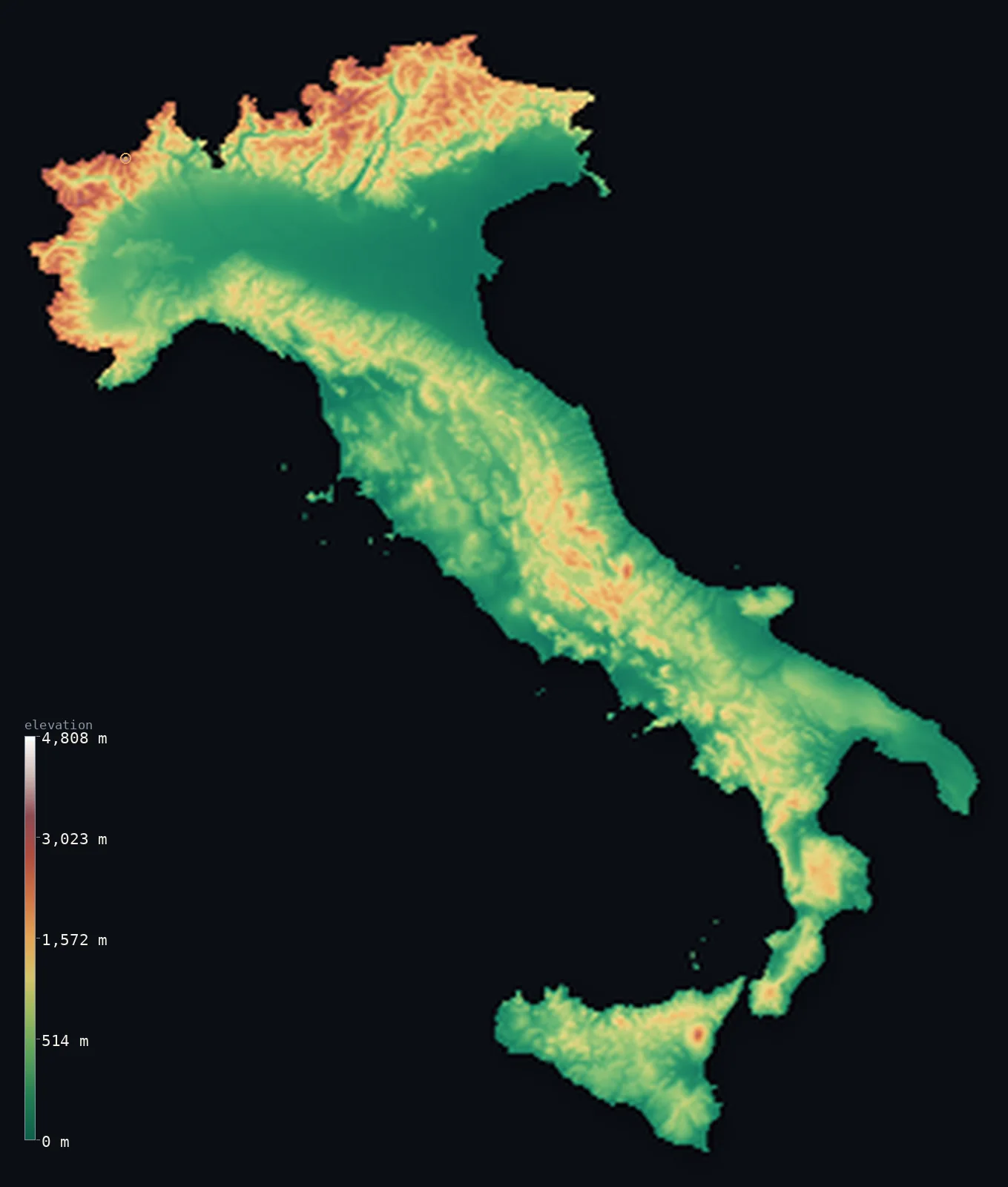
Italy’s highest point is Monte Bianco (Mont Blanc) at 15,768 ft (4,806 m); its lowest is Mediterranean Sea at 0 ft (0 m); the mean elevation is 1,814 ft (553 m).
Italy is really four landscapes in one. In the north, the Alps form a great wall along the border; below them spreads the flat Po Valley, the country's only large plain; and down the length of the peninsula runs the Apennine spine, ending in the volcanic south and the islands of Sicily and Sardinia. The country is genuinely mountainous — only 62% lies below 500 m (1,640 ft) — and its high point, Monte Bianco (Mont Blanc) at 15,768 ft (4,806 m), crowns the Alps on the French border.
- Highest point📚
- 15,768 ft4,806 m
- Italy's highest point is Monte Bianco (Mont Blanc) at 15,768 ft (4,806 m), the summit of the Alps on the French border. Its exact border line is drawn differently by Italy and France; the highest peak lying wholly within Italy is Gran Paradiso at 13,323 ft (4,061 m).
- Lowest point📚
- 0 ft0 m
- Italy's lowest point lies in the Po delta, about 10 ft (3 m) below sea level — reclaimed farmland where the great river spreads into the Adriatic, sinking slowly as its soft ground compacts.
- Mean elevation⚙
- 1,814 ft553 m
- Italy's mean elevation computed from the GLO-30 model is 1,814 ft (553 m) — genuinely high for a European country, because Italy is mountainous end to end: the Alps in the north and the Apennines running the entire length of the peninsula, with only the Po plain to lower the average.
- Median elevation⚙
- 1,132 ft345 m
- Half of Italy lies above 1,132 ft (345 m), an unusually high median, and the clearest sign of how thoroughly mountainous the country is — outside the Po Valley, level ground is scarce.
- Elevation range📚
- 15,768 ft4,806 m
- From the Po delta below sea level to the summit of Monte Bianco, Italy spans nearly 15,800 ft — the full sweep from Adriatic marsh to the highest ice of the Alps, most of it packed into the mountainous north.
- Above 1,000 m (3,281 ft)⚙
- 18%
- About 18% of Italy rises above 1,000 m (3,281 ft) — far more than most of Europe — taking in the high Alps, the crest of the Apennines, and the flanks of the great volcanoes.
- Above 2,000 m (6,562 ft)⚙
- 4%
- Around 4% of Italy stands above 2,000 m (6,562 ft), concentrated in the Alpine north and the highest Apennine massifs — the country's true high mountain, snow-covered for much of the year.
- Official area📚
- 116,348 mi²301,340 km²
- Italy covers about 116,000 sq mi (301,000 sq km) — a long peninsula plus Sicily, Sardinia, and many smaller islands, stretching from the Alpine wall in the north almost to the coast of Africa.
- Forest cover📚
- 32.5%
- About 32% of Italy is forested, climbing the slopes of the Alps and the Apennines — the mountainous spine of the country holds most of its woodland, while the Po plain and the coasts are farmed and built.
Highest and lowest points
Italy's highest point is Monte Bianco — Mont Blanc — at 15,768 ft (4,806 m), the summit of the Alps, shared with France on the northwestern border. Because Italy and France draw the summit border differently, the highest point lying entirely within Italy is Gran Paradiso (13,323 ft / 4,061 m). Italy's Alpine frontier also carries Monte Rosa and the Matterhorn, both shared with Switzerland — a crowd of the highest peaks in the Alps along the country's northern edge.
source ↗Italy's lowest point is in the Po delta on the Adriatic, about 10 ft (3 m) below sea level. It is reclaimed land where the Po, Italy's greatest river, spreads into a maze of channels and lagoons — flat, sinking country, kept dry by drainage, at the very bottom of the mountainous peninsula.
source ↗Italy at a glance
Italy's highest point, Monte Bianco (Mont Blanc, 4,806 m), is shared with France - the highest peak lying wholly within Italy is Gran Paradiso, 4,061 m.
source ↗Italy is mountainous end to end - the Alps across the north and the Apennines running the full length of the peninsula - with only the Po Valley as a large plain.
source ↗Mount Etna on Sicily, about 3,357 m, is the highest and most active volcano in continental Europe, erupting frequently.
source ↗The Po Valley in the north is Italy's only extensive lowland and its agricultural and industrial heartland - and its delta lies below sea level.
source ↗Italy has some of the most famous volcanoes on Earth - Etna, Vesuvius near Naples, and Stromboli - a legacy of its position where the African and European plates collide.
source ↗Along its Alpine border Italy shares several of the highest peaks in the Alps - Monte Bianco with France, Monte Rosa and the Matterhorn with Switzerland.
source ↗The Apennine mountains form the backbone of the Italian peninsula, running about 1,200 km from the north to the toe of the boot.
source ↗
Elevation profile of Italy
The largest share of land, 60%, falls in the 0–500 m band, and 62% of the territory lies below 500 m (1,640 ft).
- below 500 m (1,640 ft)62%
- 500–1,000 m21%
- 1,000–2,000 m13%
- above 2,000 m (6,562 ft)4%
Highest peaks of Italy
| Peak | Elevation | Range | Note |
|---|---|---|---|
| Monte Bianco (Mont Blanc)↗ | 15,768 ft4,806 m | Graian Alps (France border) | Highest point of Italy and of the Alps, on the French border; its summit sovereignty is disputed. |
| Monte Rosa (Dufourspitze)↗ | 15,203 ft4,634 m | Pennine Alps (Switzerland border) | The Monte Rosa massif on the Swiss border; its highest summit, the Dufourspitze, lies just over the line in Switzerland. |
| Cervino (Matterhorn)↗ | 14,692 ft4,478 m | Pennine Alps (Switzerland border) | The iconic pyramidal Matterhorn, on the border above Breuil-Cervinia. |
| Gran Paradiso↗ | 13,323 ft4,061 m | Graian Alps | The highest mountain lying entirely within Italy, in its own national park. |
| Etna↗ | 11,014 ft3,357 m | Sicily | The highest active volcano in Europe, on the island of Sicily; its height changes with eruptions. |
| Corno Grande↗ | 9,554 ft2,912 m | Apennines (Gran Sasso) | The highest peak of the Apennines, the chain that runs the length of peninsular Italy. |
The four faces of Italy
The Alps and the Po Valley (north)
Northern Italy pairs the highest ground with the flattest: the Alps form a great wall along the border, carrying Monte Bianco, Monte Rosa, and the Matterhorn, while below them spreads the Po Valley, Italy's only large plain and its economic heartland — flat, fertile, and at its Adriatic delta, below sea level.
The Apennine spine (the peninsula)
Down the length of the peninsula runs the Apennine range, a mountainous backbone some 1,200 km long that leaves little level ground on either side. It defines the shape of peninsular Italy, its ridges and valleys shaping the country from Genoa to the toe of the boot.
The volcanic south and the islands
The south and islands are volcanic country — Vesuvius above Naples, Etna towering over Sicily, Stromboli offshore — where the African and European plates collide. Sicily and Sardinia, the two great islands, add their own mountains to the mix.
How to read this map
Color shows elevation; the raised relief shows real terrain. On this map Italy reads as a mountainous ribbon — the white wall of the Alps in the north, the flat green of the Po plain, and the brown Apennine spine running the length of the peninsula to the volcanic south.
The 3D relief is the actual GLO-30 elevation data, exaggerated vertically so the mountains and the plain both show; the ×N relief slider controls how much. Tap anywhere to read that point's exact elevation.
City elevations in Italy
Italian cities sit mostly low despite the mountainous country - Rome and Milan on plains and river valleys, the coastal cities at sea level. Turin, on the edge of the Po plain beneath the Alps, is among the higher of the large cities.
| City | Population | Elevation |
|---|---|---|
| Romecapitalthe capital, on the low hills and floodplain of the Tiber, near 20 m ↗ | 2,318,895 | 174 ft53 m |
| Milanon the flat Po plain in the north, beneath the distant Alps ↗ | 1,371,498 | 466 ft142 m |
| Naples | 909,048 | 72 ft22 m |
| Turinon the western edge of the Po plain at the foot of the Alps, at about 240 m ↗ | 847,287 | 810 ft247 m |
| Palermo | 648,260 | 72 ft22 m |
| Genoa | 580,097 | 52 ft16 m |
| Bologna | 394,843 | 243 ft74 m |
| Bari | 316,491 | 56 ft17 m |
| Catania | 311,584 | 112 ft34 m |
| Verona | 258,031 | 217 ft66 m |
Elevation sampled at each city centre from the Copernicus GLO-30 model. Cities and population from GeoNames (CC-BY 4.0).
Italy in comparison
Italy's terrain rises 15,768 ft (4,806 m) from sea level to Monte Bianco (Mont Blanc) — about 54% of the height of Mount Everest, the world's highest point at 29,032 ft (8,849 m).
- France's mean elevation is 1,122 ft — 692 ft lower; its high point, Mont Blanc, reaches 15,768 ft (4,806 m), 0 ft above. France elevation map →
- Switzerland's mean elevation is 4,301 ft — 2,487 ft higher; its high point, Dufourspitze (Monte Rosa), reaches 15,203 ft (4,634 m), 564 ft below. Switzerland elevation map →
- Austria's mean elevation is 3,127 ft — 1,312 ft higher; its high point, Grossglockner, reaches 12,461 ft (3,798 m), 3,307 ft below. Austria elevation map →
Frequently asked questions
What is the highest point in Italy?
- Monte Bianco (Mont Blanc), 15,768 ft (4,806 m), shared with France on the northern border. The highest peak lying wholly within Italy is Gran Paradiso, 13,323 ft (4,061 m).
What is the lowest point in Italy?
- The Po delta on the Adriatic, about 10 ft (3 m) below sea level - reclaimed, slowly sinking land where the river meets the sea.
Is Mount Etna the highest volcano in Europe?
- Etna, about 3,357 m on Sicily, is the highest and most active volcano in continental Europe, erupting frequently.
How mountainous is Italy?
- Very - the Alps run across the north and the Apennines the full length of the peninsula, so only 62% of the country lies below 500 m and its median elevation is unusually high.
What is the average elevation of Italy?
- Computed from the GLO-30 model, Italy's area-weighted mean is 1,814 ft (553 m) - genuinely high for a European country, because Italy is mountainous end to end, with only the Po plain to lower it.
Is this a topographic, relief, contour, or elevation map of Italy?
- They describe the same thing - terrain height. This page renders the country's actual elevation surface in interactive 3D and reports the statistics computed from it.
About this map
The terrain is rendered from the Copernicus GLO-30 digital elevation model (ESA), masked to the ITA-ADM0 boundary from geoBoundaries (gbOpen). Elevation statistics are computed directly from the model; peak names and researched facts are sourced and cited. See the methodology for the full pipeline.
Our area-weighted mean, computed from the Copernicus GLO-30 model, is 1,814 ft (553 m); the figure commonly cited elsewhere is 1,765 ft (538 m) (CIA World Factbook). Italy is mostly hill and mountain - the Alps along the north and the Apennines down the whole peninsula - with major lowland only in the Po Valley, giving a moderate mean elevation; the page reports the area-weighted figure computed from the Copernicus GLO-30 model.
Surveyed national figures: official area · forest cover · high point.
Rendered from Copernicus GLO-30 (ESA, 2021 release), boundaries from geoBoundaries. Generated 2026-06-23.
Bordering countries · 5
Italy shares a land border with these countries — open any one to compare its terrain and highest point.