Switzerland Elevation Map — Topographic & 3D Terrain
Explore the terrain of Switzerland in interactive 3D, built from Copernicus GLO-30 satellite elevation data — a country with no low ground at all. Drag to rotate, scroll to zoom, and tap any point to read its elevation.
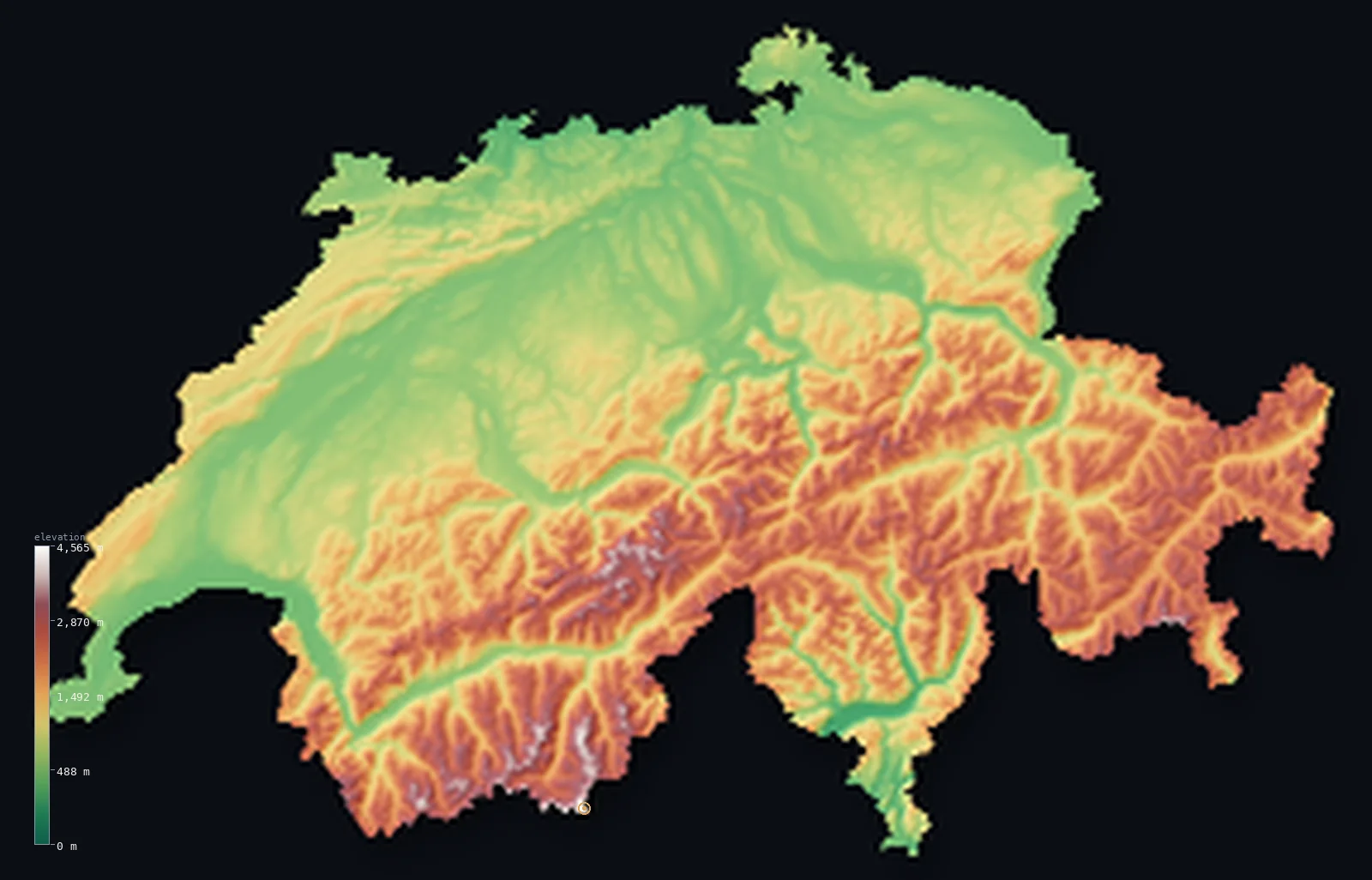
Switzerland’s highest point is Dufourspitze (Monte Rosa) at 15,203 ft (4,634 m); its lowest is Lake Maggiore at 633 ft (193 m); the mean elevation is 4,301 ft (1,311 m).
Switzerland has no lowlands. Its very lowest point, the shore of Lake Maggiore, sits at 633 ft (193 m) — higher than the highest ground in several European countries — and more than half the country lies above 3,281 ft (1,000 m). Between the Alps in the south and the Jura in the northwest runs the Swiss Plateau, a comparatively gentle band where most Swiss actually live, and above it all stands Dufourspitze at 15,203 ft (4,634 m).
- Highest point📚
- 15,203 ft4,634 m
- Switzerland's highest point is Dufourspitze, the main summit of Monte Rosa, at 15,203 ft (4,634 m) — the highest of dozens of Swiss peaks above 4,000 m, standing just inside the Italian border in the Pennine Alps.
- Lowest point📚
- 633 ft193 m
- Switzerland's lowest point is the shore of Lake Maggiore at 633 ft (193 m) above sea level — the country is landlocked and so steep that even its floor stands higher than the summits of some nations' hills.
- Mean elevation⚙
- 4,301 ft1,311 m
- Switzerland's mean elevation computed from the GLO-30 model is 4,301 ft (1,311 m) — among the highest in Europe, and unsurprising in a country where the Alps cover roughly 60% of the land.
- Median elevation⚙
- 3,576 ft1,090 m
- Half of Switzerland lies above 3,576 ft (1,090 m), close to the mean — the mark of a country that is high throughout rather than a mix of high peaks and low plains; even its inhabited middle sits well above most of Europe.
- Elevation range📚
- 14,570 ft4,441 m
- From Lake Maggiore at 633 ft to the summit of Dufourspitze, Switzerland spans about 14,570 ft — a vast range for so small a country, and one crossed within a few dozen kilometres in the steep Alpine south.
- Above 1,000 m (3,281 ft)⚙
- 53%
- About 53% of Switzerland lies above 1,000 m (3,281 ft) — a majority of the country, covering the Alpine south and east and much of the Jura, with only the Plateau and the deepest valleys sitting lower.
- Above 2,000 m (6,562 ft)⚙
- 23%
- Roughly 23% of Switzerland stands above 2,000 m (6,562 ft) — nearly a quarter of the country in genuine high-Alpine terrain of rock, snow, and glacier, above the tree line and above almost all settlement.
- Official area📚
- 15,940 mi²41,285 km²
- Switzerland covers only about 15,940 sq mi (41,288 sq km) — small enough to cross in a few hours, yet holding more than forty peaks above 4,000 m and some of the largest glaciers in the Alps.
- Forest cover📚
- 31.7%
- About 32% of Switzerland is forested, clothing the valley walls and lower slopes up to the tree line — above which the land turns to alpine pasture, bare rock, and permanent ice.
Highest and lowest points
Switzerland's highest point is Dufourspitze, 15,203 ft (4,634 m), the main summit of the Monte Rosa massif in the Pennine Alps — the highest of the more than forty Swiss peaks above 4,000 m. The summit itself lies just inside Switzerland, though the massif straddles the Italian border, as does the Matterhorn a little to the west. On this 30-metre elevation model its glaciated crest reads slightly lower than the surveyed height; the figure above is the surveyed elevation.
source ↗Switzerland's lowest point is the shore of Lake Maggiore in Ticino, at 633 ft (193 m) above sea level. In a landlocked country with no coast at all, the lakes are the floor — and that floor is remarkably high: Switzerland's lowest ground stands above the highest point of several European countries. From there the land rises in every direction, into the Alps to the south and east, the Jura to the northwest.
source ↗Switzerland at a glance
Switzerland's lowest point, the shore of Lake Maggiore at 193 m, is higher than the highest point of several European countries.
source ↗The Alps cover roughly 60% of Switzerland, and the country holds more than forty peaks above 4,000 m.
source ↗Most Swiss live on the Plateau, a band of gentler land between the Alps and the Jura that makes up about a third of the country.
source ↗The Aletsch Glacier in the Bernese Alps is the largest glacier in the Alps, and a UNESCO World Heritage site.
source ↗The Rhine and the Rhône both rise within a few kilometres of each other in the Swiss Alps and flow to opposite ends of Europe - the North Sea and the Mediterranean.
source ↗The Matterhorn and much of the Monte Rosa massif straddle the border with Italy, though Dufourspitze's summit lies on the Swiss side.
source ↗
Elevation profile of Switzerland
The largest share of land, 30%, falls in the 500–1,000 m band, and 84% of the territory lies above 500 m (1,640 ft).
- below 500 m (1,640 ft)16%
- 500–1,000 m30%
- 1,000–2,000 m30%
- above 2,000 m (6,562 ft)23%
Highest peaks of Switzerland
| Peak | Elevation | Range | Note |
|---|---|---|---|
| Dufourspitze (Monte Rosa)↗ | 15,203 ft4,634 m | Pennine Alps | Highest point of Switzerland and the second-highest of the Alps, in the Monte Rosa massif. |
| Dom↗ | 14,911 ft4,545 m | Pennine Alps (Mischabel) | The highest mountain lying entirely within Switzerland - the Dufourspitze and Matterhorn touch the Italian border. |
| Weisshorn↗ | 14,783 ft4,506 m | Pennine Alps | A great pyramidal peak of the Valais Alps, one of the highest in the country. |
| Matterhorn↗ | 14,692 ft4,478 m | Pennine Alps | Switzerland's most famous peak, on the Italian border above Zermatt - iconic, though only about the tenth-highest. |
| Finsteraarhorn↗ | 14,022 ft4,274 m | Bernese Alps | The highest peak of the Bernese Alps and the most prominent mountain in Switzerland. |
Switzerland's three bands
The Alps (south and east)
About 60% of Switzerland is Alpine — a dense mass of high ranges, deep valleys, and glaciers covering the south and east, carrying more than forty summits above 4,000 m including Dufourspitze and the Matterhorn. This is the high, thinly settled core of the country.
The Swiss Plateau (the Mittelland)
Between the Alps and the Jura runs the Plateau, a band of hills, lakes, and river valleys typically between 400 and 700 m. It is only about a third of the country's area, but it holds most of its people, cities, and farmland — the habitable middle of a mountainous state.
The Jura (northwest)
Along the French border rises the Jura, a range of long, parallel limestone folds lower than the Alps but far from gentle — forested ridges and narrow valleys that give Switzerland a second, less famous mountain system.
How to read this map
Color shows elevation; the raised relief shows real terrain. On this map Switzerland reads almost entirely in high colours — the whites and browns of the Alps filling the south and east, with the Plateau's narrower band of green between them and the folded ridges of the Jura.
The 3D relief is the actual GLO-30 elevation data, exaggerated vertically so valleys and summits both stand out; the ×N relief slider controls how much. Tap anywhere to read that point's exact elevation.
City elevations in Switzerland
Swiss cities sit on the Plateau, the band of gentler land between the mountain systems - Zürich, Bern, and Geneva all between roughly 1,200 and 1,800 ft. Even these, the country's low ground, stand higher than most European capitals.
| City | Population | Elevation |
|---|---|---|
| Zürichat the foot of its lake on the Plateau, at about 430 m ↗ | 415,367 | 1,411 ft430 m |
| Genevaat the western end of Lake Geneva where the Rhône leaves it, at about 375 m ↗ | 201,741 | 1,296 ft395 m |
| Basel | 177,595 | 922 ft281 m |
| Lausanne | 139,111 | 1,486 ft453 m |
| Berncapitalthe capital, on the Plateau above a bend of the Aare, at about 550 m ↗ | 121,631 | 1,801 ft549 m |
| Luzern | 81,691 | 1,457 ft444 m |
| Konstanz | 81,275 | 1,329 ft405 m |
| Sankt Gallen | 75,833 | 2,228 ft679 m |
| Lugano | 63,185 | 932 ft284 m |
| Fribourg | 38,365 | 2,064 ft629 m |
Elevation sampled at each city centre from the Copernicus GLO-30 model. Cities and population from GeoNames (CC-BY 4.0).
Switzerland in comparison
Switzerland's terrain rises 14,570 ft (4,441 m) from Lake Maggiore (633 ft (193 m)) to Dufourspitze (Monte Rosa) — about 50% of the height of Mount Everest, the world's highest point at 29,032 ft (8,849 m).
- Italy's mean elevation is 1,814 ft — 2,487 ft lower; its high point, Monte Bianco (Mont Blanc), reaches 15,768 ft (4,806 m), 564 ft above. Italy elevation map →
- Austria's mean elevation is 3,127 ft — 1,175 ft lower; its high point, Grossglockner, reaches 12,461 ft (3,798 m), 2,743 ft below. Austria elevation map →
- France's mean elevation is 1,122 ft — 3,179 ft lower; its high point, Mont Blanc, reaches 15,768 ft (4,806 m), 564 ft above. France elevation map →
Frequently asked questions
What is the highest point in Switzerland?
- Dufourspitze, the main summit of Monte Rosa, at 15,203 ft (4,634 m) in the Pennine Alps - the highest of more than forty Swiss peaks above 4,000 m.
What is the lowest point in Switzerland?
- The shore of Lake Maggiore at 633 ft (193 m) above sea level - Switzerland is landlocked, and even its lowest ground stands high.
What is the average elevation of Switzerland?
- Computed from the Copernicus GLO-30 model, the area-weighted mean is 4,301 ft (1,311 m) - among the highest in Europe, since the Alps cover about 60% of the country.
Where do most Swiss people live?
- On the Swiss Plateau, the band of hills and lakes between the Alps and the Jura - about a third of the country's area, holding most of its population and cities.
Is the Matterhorn in Switzerland or Italy?
- Both - the Matterhorn stands on the border, as does much of the Monte Rosa massif, though the summit of Dufourspitze itself lies on the Swiss side.
Is this a topographic, relief, contour, or elevation map of Switzerland?
- They describe the same thing - terrain height. This page renders the country's actual elevation surface in interactive 3D and reports the statistics computed from it.
About this map
The terrain is rendered from the Copernicus GLO-30 digital elevation model (ESA), masked to the CHE-ADM0 boundary from geoBoundaries (gbOpen). Elevation statistics are computed directly from the model; peak names and researched facts are sourced and cited. See the methodology for the full pipeline.
Our area-weighted mean, computed from the Copernicus GLO-30 model, is 4,301 ft (1,311 m); the figure commonly cited elsewhere is 4,429 ft (1,350 m) (CIA World Factbook). Switzerland is one of the highest countries in Europe: the Alps cover roughly the southern two-thirds and the Jura the northwest, leaving only the central Plateau at moderate height - so its mean elevation is very high; the page reports the area-weighted figure computed from the Copernicus GLO-30 model.
Surveyed national figures: official area · forest cover · high point.
Rendered from Copernicus GLO-30 (ESA, 2021 release), boundaries from geoBoundaries. Generated 2026-07-07.
Bordering countries · 5
Switzerland shares a land border with these countries — open any one to compare its terrain and highest point.