France Elevation Map — Topographic & 3D Terrain
Explore the terrain of France in interactive 3D, built from Copernicus GLO-30 satellite elevation data — broad plains ringed by three great mountain systems. Drag to rotate, scroll to zoom, and tap any point to read its elevation.
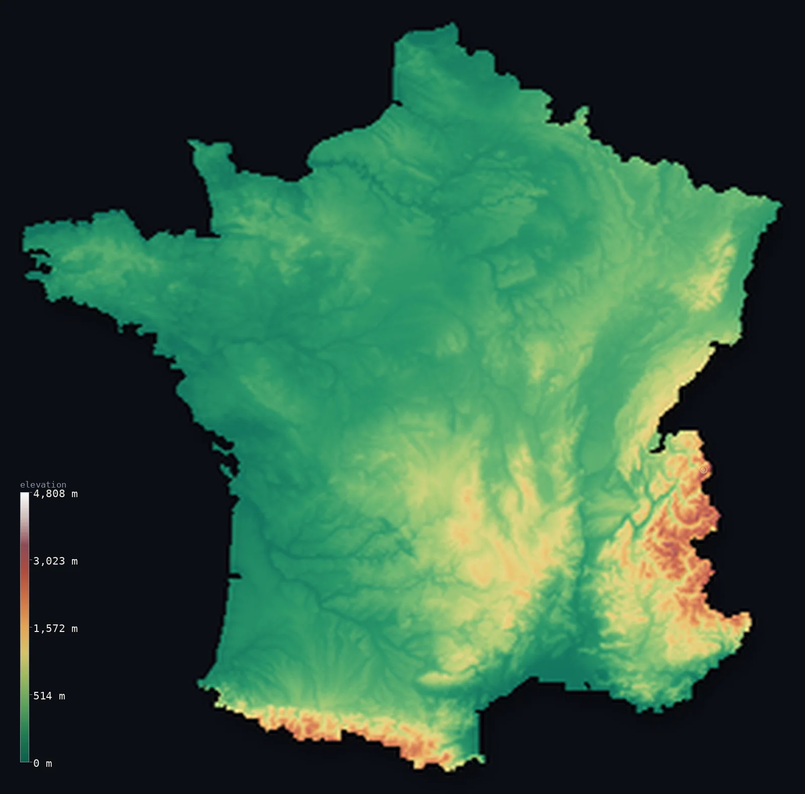
France’s highest point is Mont Blanc at 15,768 ft (4,806 m); its lowest is Rhone River delta at −7 ft (−2 m); the mean elevation is 1,122 ft (342 m).
France is a country of wide lowland ringed by mountains. More than four-fifths of it lies below 500 m (1,640 ft) — the rolling plains and river basins of the north and west — while along its edges rise three great massifs: the Alps, the Pyrenees, and the volcanic Massif Central. Highest of all, on the Italian border, stands Mont Blanc at 15,768 ft (4,806 m), the roof of the Alps and of Western Europe.
- Highest point📚
- 15,768 ft4,806 m
- France's highest point is Mont Blanc at 15,768 ft (4,806 m), the highest mountain in the Alps and in Western Europe — a great glaciated dome on the Italian border whose exact summit line France and Italy have long drawn differently on their maps.
- Lowest point📚
- −7 ft−2 m
- France's lowest point is in the Rhône delta of the Camargue, about 7 ft (2 m) below sea level — a flat expanse of lagoons and salt marsh where the river spreads into the Mediterranean.
- Mean elevation⚙
- 1,122 ft342 m
- France's mean elevation computed from the GLO-30 model is 1,122 ft (342 m) — a modest figure that reflects the country's true shape: a great deal of low plain, with the high ground pushed out to the mountainous rim.
- Median elevation⚙
- 633 ft193 m
- Half of France lies below just 633 ft (193 m), well under the mean — because the bulk of the country is low plain and gentle basin, and it is only the Alpine and Pyrenean edges that pull the average up.
- Elevation range📚
- 15,774 ft4,808 m
- From the Camargue below sea level to the summit of Mont Blanc, France spans nearly 16,000 ft of vertical relief — one of the widest ranges in Western Europe, though concentrated almost entirely in the mountainous borders.
- Above 1,000 m (3,281 ft)⚙
- 7%
- Only about 7% of France rises above 1,000 m (3,281 ft) — the Alps in the southeast, the Pyrenees along the Spanish border, and the high volcanic core of the Massif Central. The rest is low country.
- Above 2,000 m (6,562 ft)⚙
- 2%
- Just 2% of France stands above 2,000 m (6,562 ft), all of it in the high Alps and Pyrenees — a reminder that France's true high mountains are a narrow fringe on an otherwise low and open land.
- Official area📚
- 213,011 mi²551,695 km²
- France covers about 214,000 sq mi (554,000 sq km), the largest country in the European Union — room enough for broad wheat plains, three separate mountain systems, and the long river valleys of the Loire, Seine, Rhône, and Garonne.
- Forest cover📚
- 31.5%
- About 32% of France is forested, a share that has grown over the past century — heaviest in the mountains and the Landes of the southwest, thinnest across the intensively farmed northern plains.
Highest and lowest points
France's highest point is Mont Blanc, 15,768 ft (4,806 m), the highest summit in the Alps and in Western Europe, standing on the border with Italy above the town of Chamonix. Its icy dome has been a birthplace of mountaineering since the first ascent in 1786. The exact position of the summit border is drawn differently by French and Italian maps, so the peak is in a sense shared between the two countries.
source ↗France's lowest point lies in the Camargue, the delta where the Rhône reaches the Mediterranean, about 7 ft (2 m) below sea level. It is a flat wilderness of lagoons, reed beds, and salt pans — famous for its wild horses and flamingos — where the river's sediment and the sea meet at the very bottom of the country.
source ↗France at a glance
Mont Blanc, 4,806 m, is the highest mountain in the Alps and in Western Europe - and its summit border is drawn differently by France and Italy.
source ↗More than four-fifths of France lies below 500 m - the country is mostly low plain, with its high mountains confined to the Alpine, Pyrenean, and Massif Central rims.
source ↗The Massif Central is an ancient volcanic upland in the country's centre, its chain of extinct volcanoes - the Chaîne des Puys - a UNESCO World Heritage site.
source ↗The Pyrenees form a natural wall along the entire border with Spain, rising above 3,000 m.
source ↗France's lowest point, in the Rhône delta of the Camargue, lies about 2 m below sea level among lagoons and salt marsh.
source ↗France is the largest country in the European Union by area, spanning wheat plains, three mountain systems, and four major river basins.
source ↗
Elevation profile of France
The largest share of land, 80%, falls in the 0–500 m band, and 81% of the territory lies below 500 m (1,640 ft).
- below 500 m (1,640 ft)81%
- 500–1,000 m12%
- 1,000–2,000 m6%
- above 2,000 m (6,562 ft)2%
Highest peaks of France
| Peak | Elevation | Range | Note |
|---|---|---|---|
| Mont Blanc↗ | 15,768 ft4,806 m | Alps (Mont Blanc massif) | Highest point of France and the Alps, an ice-capped summit on the Italian border. |
| Barre des Ecrins↗ | 13,458 ft4,102 m | Alps (Dauphine / Ecrins) | The highest peak lying entirely within France, in the Ecrins massif of the Dauphine Alps. |
| Vignemale↗ | 10,820 ft3,298 m | Pyrenees (Spain border) | The highest summit of the French Pyrenees, on the Spanish border above the Ossoue Glacier. |
| Monte Cinto↗ | 8,878 ft2,706 m | Corsica | The highest peak of the Mediterranean island of Corsica. |
| Puy de Sancy↗ | 6,184 ft1,885 m | Massif Central | The highest point of the volcanic Massif Central in south-central France. |
The shape of France
The northern and western plains
Most of France is low, open country — the wide basins of the Seine and the Loire, the plains of the north, and the rolling farmland of the west. This is the productive heart of the country, rarely rising far above sea level.
The mountain rim: Alps, Pyrenees, and Massif Central
France's high ground is pushed to its edges and centre — the Alps in the southeast rising to Mont Blanc, the Pyrenees walling off Spain, and the ancient volcanic Massif Central in the middle. Together they hold almost all the country's high terrain.
The Mediterranean south
Toward the Mediterranean the land drops through Provence and the Rhône valley to the coast, ending in the flat delta of the Camargue — warmer, drier country, and the site of the country's lowest point.
How to read this map
Color shows elevation; the raised relief shows real terrain. On this map France reads as a broad green lowland with a rim of brown and white — the Alps and Pyrenees standing out sharply along the borders.
The 3D relief is the actual GLO-30 elevation data, exaggerated vertically so the plains and the high massifs both show clearly; the ×N relief slider controls how much. Tap anywhere to read that point's exact elevation.
City elevations in France
French cities sit mostly low, in the plains and river valleys - Paris on the Seine, the great ports on the coasts. Only Lyon and a few others in the east and centre rise even modestly toward the mountains.
| City | Population | Elevation |
|---|---|---|
| Pariscapitalthe capital, on the Seine in the low-lying Paris Basin, near 35 m ↗ | 2,138,551 | 131 ft40 m |
| Marseille | 877,215 | 89 ft27 m |
| Lyonat the confluence of the Rhône and Saône in the east, on the approach to the Alps ↗ | 520,774 | 568 ft173 m |
| Toulouse | 511,684 | 505 ft154 m |
| Niceon the Mediterranean coast at sea level, beneath the Maritime Alps ↗ | 342,669 | 59 ft18 m |
| Nantes | 325,070 | 62 ft19 m |
| Strasbourg | 274,845 | 495 ft151 m |
| Bordeaux | 265,328 | 72 ft22 m |
| Montpellier | 248,252 | 184 ft56 m |
| Lille | 238,695 | 89 ft27 m |
Elevation sampled at each city centre from the Copernicus GLO-30 model. Cities and population from GeoNames (CC-BY 4.0).
France in comparison
France's terrain rises 15,774 ft (4,808 m) from Rhone River delta, 7 ft (2 m) below sea level to Mont Blanc — about 54% of the height of Mount Everest, the world's highest point at 29,032 ft (8,849 m).
- Spain's mean elevation is 2,274 ft — 1,152 ft higher; its high point, Mulhacen, reaches 11,414 ft (3,479 m), 4,354 ft below. Spain elevation map →
- Italy's mean elevation is 1,814 ft — 692 ft higher; its high point, Monte Bianco (Mont Blanc), reaches 15,768 ft (4,806 m), 0 ft above. Italy elevation map →
- Germany's mean elevation is 869 ft — 253 ft lower; its high point, Zugspitze, reaches 9,718 ft (2,962 m), 6,050 ft below. Germany elevation map →
Frequently asked questions
What is the highest point in France?
- Mont Blanc, 15,768 ft (4,806 m), on the Italian border - the highest mountain in the Alps and in Western Europe.
What is the lowest point in France?
- The Rhône delta in the Camargue, about 7 ft (2 m) below sea level - a flat expanse of lagoons and salt marsh.
What are France's main mountain ranges?
- Three: the Alps in the southeast (rising to Mont Blanc), the Pyrenees along the Spanish border, and the ancient volcanic Massif Central in the country's centre.
Why is most of France so flat?
- The bulk of France is low plain and river basin - more than four-fifths lies below 500 m - with its high mountains confined to the Alpine, Pyrenean, and central rims.
What is the average elevation of France?
- Computed from the GLO-30 model, France's area-weighted mean is 1,122 ft (342 m) - a modest figure, since most of the country is low plain with its high ground pushed to the mountainous rim.
Is this a topographic, relief, contour, or elevation map of France?
- They describe the same thing - terrain height. This page renders the country's actual elevation surface in interactive 3D and reports the statistics computed from it.
About this map
The terrain is rendered from the Copernicus GLO-30 digital elevation model (ESA), masked to the FRA-ADM0 boundary from geoBoundaries (gbOpen). Elevation statistics are computed directly from the model; peak names and researched facts are sourced and cited. See the methodology for the full pipeline.
Our area-weighted mean, computed from the Copernicus GLO-30 model, is 1,122 ft (342 m); the figure commonly cited elsewhere is 1,230 ft (375 m) (CIA World Factbook). Metropolitan France is mostly low plains and plateaus in the north and west, rising to high mountains only in the southeast (Alps) and southwest (Pyrenees), giving a moderate mean; the page reports the area-weighted figure computed from the Copernicus GLO-30 model for metropolitan France.
Surveyed national figures: official area · forest cover · high point.
Rendered from Copernicus GLO-30 (ESA, 2021 release), boundaries from geoBoundaries. Generated 2026-06-23.
Bordering countries · 8
France shares a land border with these countries — open any one to compare its terrain and highest point.