Europe Elevation Map
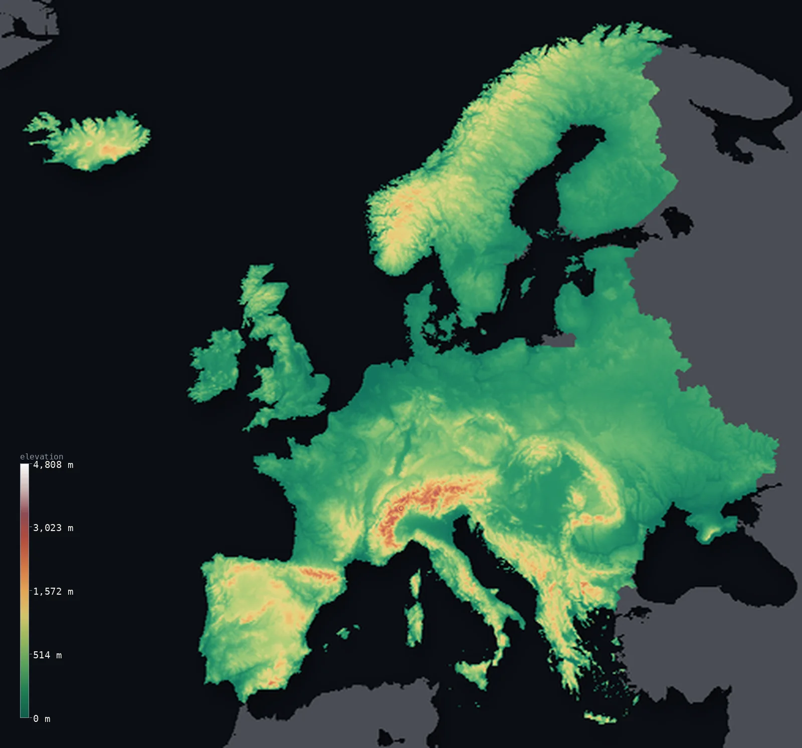
Europe’s highest point is Mont Blanc at 15,781 ft (4,810 m); its lowest is Dutch and Danish polders at −23 ft (−7 m); the mean elevation is 1,161 ft (354 m).
- Highest point📚
- 15,781 ft4,810 m
- Europe's highest point, within the bounds of this map, is Mont Blanc at 15,781 ft (4,810 m), in the Alps on the border of France and Italy - a great glaciated massif, the crown of the Alpine chain that walls southern Europe. (Mount Elbrus, in the Caucasus, is higher at 5,642 m, but because this map groups transcontinental Russia with Asia, Elbrus lies beyond the eastern edge of this view; Mont Blanc is the highest summit wholly within Europe.) The Alps are Europe's great mountain wall, a high glaciated range curving through the center of the continent, of which Mont Blanc is the summit.
- Lowest point📚
- −23 ft−7 m
- The lowest land on this map of Europe is in the Dutch and Danish polders - reclaimed land along the North Sea, about 23 ft (7 m) below sea level, the lowest of it at Denmark's Lammefjord. These are lands won from the sea and held below it by dikes and pumps. (The conventional lowest point of Europe, the shore of the Caspian Sea at about 28 m below sea level, lies in European Russia - which this map groups with Asia - beyond the eastern edge of this view.)
- Mean elevation⚙
- 1,161 ft354 m
- Computed from the GLO-30 model, Europe's mean elevation is 1,161 ft (354 m) - a modest figure, and the median is lower still: half of Europe lies below about 663 ft (202 m). For all its famous mountains, Europe is mostly a continent of plains and low hills. The vast North European Plain sweeps from France across Germany and Poland into Russia; only in the south do the Alps, Pyrenees, and Carpathians rise high, and in the north the Scandinavian mountains - the highlands are the exception that lifts the average above the low, broad body of the continent.
- Median elevation⚙
- 663 ft202 m
- Half of Europe lies below about 663 ft (202 m) - lower than the mean, because Europe, despite the Alps, is for the most part a low continent. The great North European Plain, running from the Atlantic coast of France across Germany and Poland far into Russia, is the broad low body of Europe; the high ground - the Alps, the Pyrenees, the Carpathians, the Scandinavian mountains - is a minority that lifts the average above the typical, low point.
- Elevation range📚
- 15,804 ft4,817 m
- From the Dutch and Danish polders at about 7 m below sea level to the summit of Mont Blanc at 4,810 m, the terrain on this map of Europe spans about 15,804 ft - from land reclaimed below the North Sea up to the high glaciers of the Alps. (Higher ground still, Mount Elbrus in the Caucasus, lies beyond the map's eastern edge, in the part grouped with Asia.)
- Above 1,000 m (3,281 ft)⚙
- 7%
- About 7% of Europe rises above 1,000 m (3,281 ft) - chiefly the great southern ranges (the Alps, Pyrenees, Carpathians, and the Balkan and Iberian highlands) and the Scandinavian mountains of the north. Most of the continent - the vast North European Plain and the lowlands and low hills - lies well below.
- Official area📚
- 3,930,518 mi²10,180,000 km²
- Europe, on this map (grouping transcontinental Russia and Turkey with Asia), covers about 3,930,518 sq mi (10,180,000 sq km) - from the Atlantic and the Mediterranean in the west and south to the edge of European Russia in the east, and from the Scandinavian north to the Mediterranean shores. Its body is the vast North European Plain and the lowlands; its high ground is the Alpine chain and the southern ranges, with the Scandinavian mountains in the north.
- Forest cover📚
- 33%
- About 33% of Europe is forested - from the boreal coniferous forests of Scandinavia and northern Russia, through the mixed and temperate deciduous forests of the center, to the Mediterranean woodland and scrub of the south, much of the original forest long cleared for the farmland of the great plains.
Europe at a glance
Europe's highest wholly-European summit, Mont Blanc, is far lower than Elbrus in the Caucasus - which many lists count as European.
source ↗Apart from its southern mountain belt, Europe is remarkably low and flat, dominated by the North European Plain.
source ↗Europe has more coastline relative to its area than any other continent, thanks to its peninsulas and islands.
source ↗The Caspian Sea shore - by convention Europe's lowest point, below sea level - straddles the Europe-Asia divide; on this map it lies in the part grouped with Asia, so the lowest ground shown here is the Dutch and Danish polders.
source ↗Where Europe ends and Asia begins is a convention, not a natural border - the two share one landmass.
source ↗
Elevation profile of Europe
The largest share of land, 76%, falls in the 0–500 m band, and 76% of the territory lies below 500 m (1,640 ft).
- below 500 m (1,640 ft)76%
- 500–1,000 m16%
- 1,000–2,000 m6%
- above 2,000 m (6,562 ft)1%
Highest and lowest points
The highest point of Europe on this map is Mont Blanc, 4,810 m, in the Alps on the France-Italy border - the highest summit wholly within Europe. (Mount Elbrus in the Caucasus is higher at 5,642 m, but because this map groups transcontinental Russia with Asia, Elbrus appears there; Mont Blanc is the highest point of the European countries shown here.)
source ↗The lowest land of Europe on this map is the Dutch and Danish polders - reclaimed ground along the North Sea, held below the sea by dikes and pumps, reaching about 7 m below sea level at Denmark's Lammefjord. (The conventional lowest point of Europe, the Caspian Sea shore at about 28 m below sea level, lies in European Russia - which this map groups with Asia - beyond the eastern edge of this view; the polders are the lowest ground of the European countries shown here.)
source ↗Highest peaks of Europe
| Peak | Elevation | Range | Note |
|---|---|---|---|
| Mont Blanc↗ | 15,781 ft4,810 m | Alps | Highest point wholly within Europe, on the France-Italy border. |
| Dufourspitze↗ | 15,203 ft4,634 m | Alps (Monte Rosa) | The highest peak of Switzerland, in the Monte Rosa massif. |
| Matterhorn↗ | 14,692 ft4,478 m | Alps | An iconic pyramidal peak on the Swiss-Italian border. |
| Aneto↗ | 11,168 ft3,404 m | Pyrenees | The highest peak of the Pyrenees, in Spain. |
| Gerlachovsky stit↗ | 8,711 ft2,655 m | Carpathians (Tatras) | The highest peak of the Carpathians, in Slovakia. |
Terrain regions of Europe
Europe's highest wholly-European summit, Mont Blanc, is far lower than Elbrus in the Caucasus - which many lists count as European. ↗
The North European Plain
↗The vast lowland sweeping from France across Germany and Poland into Russia - the flat, fertile heart of the continent.
The southern mountains
↗The high mountain belt of the south - the Pyrenees, Alps, Apennines, Carpathians and Balkans - holding nearly all of Europe's high ground.
The northern uplands and peninsulas
↗The worn Scandinavian and British highlands of the north and northwest, and the deeply indented peninsulas and islands of the Atlantic and Mediterranean.
The North European Plain
the centre and eastAcross the centre of Europe runs the North European Plain, a broad belt of low, flat, fertile land stretching from western France through the Low Countries, northern Germany and Poland into the vast plains of European Russia. Rarely far above sea level, drained by great rivers like the Rhine, Elbe, Vistula and Volga, this plain is the demographic and agricultural heart of the continent, and its openness has shaped European history.
The southern mountain belt
the southNearly all of Europe's high ground lies in a chain of young mountains along the south, thrown up where Africa presses against Europe. The Alps are the highest and most central, crowned by Mont Blanc (4,810 m) on the France-Italy border; to the west stand the Pyrenees between France and Spain, to the east the Carpathians and the Balkan ranges, and down the Italian spine the Apennines. These mountains wall the plains from the Mediterranean.
The northern uplands and coasts
the north and coastsIn the north and northwest, older and lower highlands rise from the plain - the glacier-carved mountains and fjords of Scandinavia, and the worn uplands of Britain and Ireland. Europe's long, ragged coastline breaks into great peninsulas - Iberia, Italy, the Balkans, Scandinavia - and countless islands, giving the continent more coast for its size than any other.
City elevations in Europe
| City | Population | Elevation |
|---|---|---|
| Londoncapital | 8,961,989 | 69 ft21 m |
| Berlincapital | 3,426,354 | 138 ft42 m |
| Madridcapital | 3,255,944 | 2,192 ft668 m |
| Kyivcapital | 2,952,301 | 607 ft185 m |
| Romecapital | 2,318,895 | 174 ft53 m |
| Pariscapital | 2,138,551 | 131 ft40 m |
| Hamburg | 1,973,896 | 46 ft14 m |
| Bucharestcapital | 1,877,155 | 276 ft84 m |
| Minskcapital | 1,742,124 | 725 ft221 m |
| Budapestcapital | 1,741,041 | 381 ft116 m |
Elevation sampled at each city centre from the Copernicus GLO-30 model. Cities and population from GeoNames (CC-BY 4.0).
Europe in comparison
Europe's terrain rises 15,804 ft (4,817 m) from Dutch and Danish polders, 23 ft (7 m) below sea level to Mont Blanc — about 54% of the height of Mount Everest, the world's highest point at 29,032 ft (8,849 m).
- World's mean elevation is 2,628 ft — 1,467 ft higher; its high point, Mount Everest, reaches 29,032 ft (8,849 m), 13,251 ft above. World elevation map →
- Asia's mean elevation is 2,631 ft — 1,470 ft higher; its high point, Mount Everest, reaches 29,032 ft (8,849 m), 13,251 ft above. Asia elevation map →
- Africa's mean elevation is 2,054 ft — 892 ft higher; its high point, Mount Kilimanjaro, reaches 19,341 ft (5,895 m), 3,560 ft above. Africa elevation map →
Frequently asked questions
What is the highest point in Europe?
- Within this map, Mont Blanc, 15,781 ft (4,810 m), in the Alps (France/Italy) - the highest summit wholly in Europe. (Elbrus, 5,642 m, in the Caucasus, is higher but lies in the part grouped with Asia.)
Is Mont Blanc or Elbrus the highest point in Europe?
- It depends where you draw the Europe-Asia line. Elbrus (5,642 m) is higher, but Mont Blanc (4,810 m) is the highest peak indisputably within Europe; this map shows Elbrus with Asia.
What is the lowest point in Europe?
- On this map, the Dutch and Danish polders, about 23 ft (7 m) below sea level (lowest at Denmark's Lammefjord). The conventional lowest point of Europe, the Caspian shore (about 28 m below sea level), lies in European Russia, beyond the map's eastern edge.
What is the average elevation of Europe?
- Computed from the GLO-30 model, about 1,161 ft (354 m) - and half of Europe lies below about 663 ft (202 m), because for all its famous mountains Europe is mostly a continent of plains, dominated by the great North European Plain.
Is Europe mostly mountainous?
- No - despite the Alps and other famous ranges, Europe is mostly low. The vast North European Plain is the broad body of the continent; the mountains are high but local, lifting the average above a low typical elevation.
Why is Russia shown with Asia and not Europe?
- Russia straddles both, but most of its land is in Asia, so this map groups it there - which is also why Europe's high point here is Mont Blanc rather than Elbrus.
Is this a topographic, relief, contour, or elevation map of Europe?
- They describe the same thing - terrain height. This page renders Europe's actual elevation surface in interactive 3D (a relief or topographic view) and reports the statistics computed from it; a contour map shows the same data as lines of equal height.
About this map
The terrain is rendered from the Copernicus GLO-30 digital elevation model (ESA), masked to the CONTINENT-EUROPE boundary from geoBoundaries (gbOpen). Elevation statistics are computed directly from the model; peak names and researched facts are sourced and cited. See the methodology for the full pipeline.
This map renders 5,885,115 km² across 6045 landmasses of Europe. 2190 smaller outlying parts — 37,101 km² in total — lie beyond the area shown here. Area statistics above count the full territory.
Because Europe covers 5,885,115 km², its 3D terrain surface is rendered at roughly 4.0 km per pixel rather than the model’s native 30 m — the full-resolution grid exceeds the render budget for an area this large. The high point and every elevation figure on this page are still measured at native 30 m resolution; only the rendered surface detail is coarsened.
Our area-weighted mean, computed from the Copernicus GLO-30 model, is 1,161 ft (354 m); no authority publishes a mean elevation (no single authoritative continental mean). For a continent so associated with its mountains, Europe is mostly low. Its mean elevation is just 1,161 ft (354 m), and half the continent lies below about 663 ft (202 m) - lower still. The reason is the great North European Plain: a vast belt of low ground sweeping from the Atlantic coast of France across the Low Countries, Germany, and Poland far into Russia, the broad body of the continent. The famous heights are real but local - the Alps curving through the center (holding Mont Blanc, the highest point on this map), the Pyrenees along the Spanish border, the Carpathians of the east, the Scandinavian mountains of the north - and they lift the average above the low, typical ground without making Europe a high continent. (Higher than any of them, Mount Elbrus in the Caucasus stands beyond this map's eastern edge, in the part grouped with Asia; and the lowest land here is not a natural basin but the Dutch and Danish polders, reclaimed and held below the sea.) No single authoritative figure for the mean elevation of a whole continent is published; the value here is computed directly from the GLO-30 elevation surface.
Surveyed national figures: official area · forest cover · high point.
Rendered from Copernicus GLO-30 (ESA, 2021 release), boundaries from geoBoundaries. Generated 2026-07-16.
Countries in Europe · 44
Every country in Europe on the same elevation scale — open any one for its full 3D map and statistics.
- Albania
- Andorra
- Austria
- Belarus
- Belgium
- Bosnia and Herzegovina
- Bulgaria
- Croatia
- Czechia
- Denmark
- Estonia
- Finland
- France
- Germany
- Greece
- Hungary
- Iceland
- Ireland
- Italy
- Kosovo
- Latvia
- Liechtenstein
- Lithuania
- Luxembourg
- Malta
- Moldova
- Monaco
- Montenegro
- Netherlands
- North Macedonia
- Norway
- Poland
- Portugal
- Romania
- Russia
- San Marino
- Serbia
- Slovakia
- Slovenia
- Spain
- Sweden
- Switzerland
- Ukraine
- United Kingdom