North Macedonia Elevation Map — Topographic & 3D Terrain
Explore the terrain of North Macedonia in interactive 3D, built from Copernicus GLO-30 satellite elevation data — a landlocked upland of mountains and high basins split by the Vardar valley. Drag to rotate, scroll to zoom, and tap any point to read its elevation.
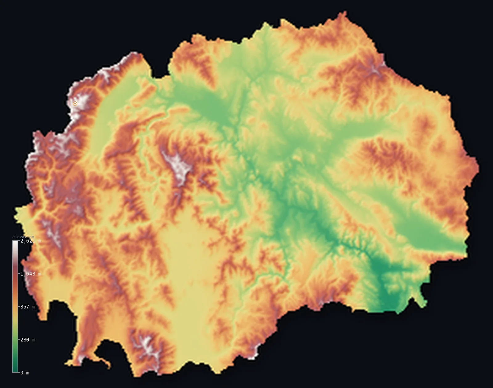
North Macedonia’s highest point is Golem Korab at 9,068 ft (2,764 m); its lowest is Vardar River at 164 ft (50 m); the mean elevation is 2,730 ft (832 m).
North Macedonia is a landlocked country of mountains and high basins. Ranges rise on every side and through the middle, cut by the valley of the Vardar, which runs from the northwest down through the country toward Greece — the main lowland corridor and the route of the country's chief river. The highest ground is on the western border: Korab, 9,068 ft (2,764 m), shared with Albania, and the Šar Mountains nearby. Almost the whole country lies above 656 ft (200 m).
- Highest point📚
- 9,068 ft2,764 m
- North Macedonia's highest point is Korab at 9,068 ft (2,764 m), on the western border with Albania — the highest peak of both countries, its summit standing on the frontier between them. It rises at the edge of the Šar Mountains and the Korab range, in the high country along the country's western boundary, the roof of an overwhelmingly upland land.
- Lowest point📚
- 164 ft50 m
- North Macedonia's lowest point is where the Vardar river crosses into Greece in the south, at about 164 ft (50 m) — the low end of the valley that drains most of the country, and its lowest ground, though still well above the distant sea.
- Mean elevation⚙
- 2,730 ft832 m
- Computed from the GLO-30 model, North Macedonia's mean elevation is 2,730 ft (832 m) — high for the region, a landlocked land of mountain and high basin: ranges wall and cross it, and even its lower ground, the Vardar valley and the basins along it, sits well up.
- Median elevation⚙
- 2,477 ft755 m
- Half of North Macedonia lies above 2,477 ft (755 m) — the Vardar valley and the lake basins carve out the low ground, but they are the exceptions: mountains and high basins fill the rest, holding even the middle of the country's elevation well up.
- Elevation range📚
- 8,904 ft2,714 m
- North Macedonia's full relief is about 8,900 ft — but it is a high country end to end: the Vardar valley that marks its low point still stands well up, and the climb to Korab on the western border rises among mountains that are high already.
- Above 1,000 m (3,281 ft)⚙
- 32%
- About 32% of North Macedonia rises above 1,000 m (3,281 ft) — the Šar Mountains and the western border ranges, and the numerous other massifs that surround the basins. The Vardar valley and the lake basins lie lower.
- Above 2,000 m (6,562 ft)⚙
- 1%
- Roughly 1% of North Macedonia stands above 2,000 m (6,562 ft) — the highest ranges, the Šar Mountains and Korab on the western border and the higher interior massifs like Baba with its peak Pelister.
- Official area📚
- 9,928 mi²25,713 km²
- North Macedonia covers about 9,900 sq mi (25,713 sq km) — a small, landlocked country in the central Balkans, mostly mountain and high basin, split from northwest to southeast by the valley of the Vardar.
- Forest cover📚
- 39.8%
- About 39.8% of North Macedonia is forested — much of it on the mountain ranges, whose slopes carry oak, beech, and pine; the Vardar valley and the basins are more cultivated, and the country has a dry, warm interior in summer.
Highest and lowest points
North Macedonia's highest point is Korab, 9,068 ft (2,764 m), on the western border — and it is the highest peak of both North Macedonia and Albania, its summit standing exactly on the frontier between them. The peak lies where the Korab range meets the Šar Mountains, the great range that walls the country's northwestern border and continues toward Kosovo. Korab's actual summit sits just at the boundary; the highest ground fully within the country lies a little lower, on the Šar ridge nearby. Either way, this western wall of mountains is the roof of a thoroughly upland country.
source ↗North Macedonia's lowest point is where the Vardar river flows out of the country into Greece in the far south, at about 164 ft (50 m) above sea level. The Vardar is the country's great river: rising in the northwest, it runs the length of North Macedonia through a valley that is the main corridor of settlement, farming, and transport, before crossing into Greece (where it is called the Axios) and reaching the Aegean. Landlocked North Macedonia drains mostly through this one valley; even its lowest ground stands well above the faraway sea.
source ↗Golem Korab is a border summit: its peak lies just outside the generalized North Macedonia boundary, so the highest fully in-territory land pixel in the model is 8,999 ft (2,743 m). The headline figure above is the surveyed elevation of the recognised national high point.
North Macedonia at a glance
Golem Korab is the highest point of two countries at once - both North Macedonia and Albania - one of only two such summits in Europe, alongside Mont Blanc.
source ↗Lake Ohrid is one of the oldest lakes in the world and among the deepest in Europe — up to 288 m deep — and a UNESCO World Heritage Site.
source ↗Lake Prespa sits about 150 m higher than nearby Lake Ohrid and drains into it through underground channels in the karst.
source ↗The Vardar River basin covers roughly two-thirds of the country, which is why the region is called 'Vardar Macedonia'.
source ↗Korab Falls on the Korab massif drops over 130 m in spring, the highest waterfall in North Macedonia.
source ↗North Macedonia is landlocked and ringed by mountains, with its highest ground concentrated along the western borders.
source ↗
Elevation profile of North Macedonia
The largest share of land, 18%, falls in the 600–800 m band, and 74% of the territory lies above 500 m (1,640 ft).
- below 500 m (1,640 ft)26%
- 500–1,000 m43%
- 1,000–2,000 m30%
- above 2,000 m (6,562 ft)1%
Highest peaks of North Macedonia
| Peak | Elevation | Range | Note |
|---|---|---|---|
| Golem Korab↗ | 9,068 ft2,764 m | Korab range (west, Albanian border) | Highest point of North Macedonia (and of Albania), a border summit in the Korab massif. |
| Titov Vrv↗ | 9,016 ft2,748 m | Sar Mountains (northwest, Kosovo border) | The highest peak of the Sar Mountains, on the northwestern border. |
| Pelister↗ | 8,533 ft2,601 m | Baba Mountains (south) | The highest peak of the Baba range, in the country's first national park. |
| Solunska Glava↗ | 8,333 ft2,540 m | Jakupica (central) | The highest peak of the central Jakupica massif, between the Vardar and Crna rivers. |
| Ruen↗ | 7,388 ft2,252 m | Osogovo Mountains (east, Bulgarian border) | The highest peak of the Osogovo range on the eastern border. |
North Macedonia: the western wall, the Vardar, and the basins
The western mountains (Šar and Korab)
The northwestern border of North Macedonia is walled by high mountains — the Šar range, shared with Kosovo, and the Korab range on the Albanian border, holding Korab, the country's high point. Steep and high, snow-capped much of the year, they are the country's tallest and most dramatic terrain.
The Vardar valley and the central basins
Through the middle of the country, from northwest to southeast, runs the valley of the Vardar — the main lowland corridor, linking a chain of basins (Skopje, Veles, and others) that hold most of the population, farming, and cities. It is the country's lower ground and its central axis.
The interior massifs and lakes
Between and around the basins rise range after range of interior mountains — the Baba massif with Pelister in the southwest, and others — and among them, on the southwestern borders, lie the ancient lakes of Ohrid and Prespa. Upland country of mountain and high lake basin, covering much of the land.
How to read this map
Color shows elevation; the raised relief shows real terrain. On this map North Macedonia reads as upland throughout — the high white-and-brown wall of the Šar Mountains and Korab along the northwestern border, range after range of interior massifs in browns, and the green thread of the Vardar valley winding northwest to southeast through the middle, with the lake basins set among the mountains.
The 3D relief is the actual GLO-30 elevation data, exaggerated vertically so the western wall and the Vardar corridor both show; the ×N relief slider controls how much. Tap anywhere to read that point's exact elevation.
City elevations in North Macedonia
North Macedonia's cities sit in the Vardar valley and the basins along it — Skopje, the capital, in a basin in the north, Bitola and Prilep in the southern Pelagonia basin, Tetovo below the Šar in the northwest, Ohrid by its lake in the southwest. Nearly all sit in the lower basins, not the surrounding mountains.
| City | Population | Elevation |
|---|---|---|
| Skopjecapitalthe capital, in a basin on the Vardar in the north ↗ | 474,889 | 820 ft250 m |
| Kumanovoin the north, in a basin near the Serbian border ↗ | 75,051 | 1,122 ft342 m |
| Prilepin the Pelagonia basin of the south ↗ | 73,814 | 2,149 ft655 m |
| Bitolain the Pelagonia basin below the Baba massif and Pelister ↗ | 69,287 | 2,021 ft616 m |
| Tetovoin the northwest below the Šar Mountains ↗ | 63,176 | 1,542 ft470 m |
| Veleson the Vardar in the centre of the country ↗ | 57,873 | 617 ft188 m |
| Gostivarin the upper Vardar (Polog) valley, below the Šar ↗ | 50,974 | 1,752 ft534 m |
| Shtipin the east, in the Bregalnica valley ↗ | 48,279 | 965 ft294 m |
| Centar Župaa highland municipality in the west, near the Albanian border ↗ | 45,412 | 2,431 ft741 m |
| Ohridon the shore of Lake Ohrid in the southwest ↗ | 42,033 | 2,306 ft703 m |
Elevation sampled at each city centre from the Copernicus GLO-30 model. Cities and population from GeoNames (CC-BY 4.0).
North Macedonia in comparison
North Macedonia's terrain rises 8,904 ft (2,714 m) from Vardar River (164 ft (50 m)) to Golem Korab — about 31% of the height of Mount Everest, the world's highest point at 29,032 ft (8,849 m).
- Albania's mean elevation is 2,254 ft — 476 ft lower; its high point, Mount Korab, reaches 9,068 ft (2,764 m), 0 ft above. Albania elevation map →
- Kosovo's mean elevation is 2,654 ft — 75 ft lower; its high point, Gjeravica (Deravica), reaches 8,714 ft (2,656 m), 354 ft below. Kosovo elevation map →
- Bulgaria's mean elevation is 1,562 ft — 1,168 ft lower; its high point, Musala, reaches 9,596 ft (2,925 m), 528 ft above. Bulgaria elevation map →
Frequently asked questions
What is the highest point in North Macedonia?
- Korab, 9,068 ft (2,764 m), on the western border with Albania — the highest peak of both countries, its summit on the frontier. The highest ground fully within the country, on the nearby Šar ridge, is a little lower.
What is the lowest point in North Macedonia?
- Where the Vardar river crosses into Greece in the south, at about 164 ft (50 m) — low, but well above sea level, as the country is landlocked.
What is the average elevation of North Macedonia?
- Computed from the Copernicus GLO-30 model, the area-weighted mean is 2,730 ft (832 m) — high, because the country is largely mountain and high basin, with the Vardar valley the main lower ground.
Is North Macedonia mountainous?
- Largely — ranges surround and cross the country, and about half of it lies above 755 m. The Vardar valley and the lake basins are the main lower ground; the western border holds the highest mountains.
What is Lake Ohrid?
- One of the oldest and deepest lakes in Europe, on North Macedonia's southwestern border with Albania — an ancient lake home to many species found nowhere else.
Is this a topographic, relief, contour, or elevation map of North Macedonia?
- They describe the same thing — terrain height. This page renders the country's actual elevation surface in interactive 3D and reports the statistics computed from it.
About this map
The terrain is rendered from the Copernicus GLO-30 digital elevation model (ESA), masked to the MKD-ADM0 boundary from geoBoundaries (gbOpen). Elevation statistics are computed directly from the model; peak names and researched facts are sourced and cited. See the methodology for the full pipeline.
Our area-weighted mean, computed from the Copernicus GLO-30 model, is 2,730 ft (832 m); the figure commonly cited elsewhere is 2,431 ft (741 m) (CIA World Factbook). North Macedonia is a rugged, landlocked country - the central Vardar valley framed by high mountain ranges on almost every side - so its mean elevation is high; the page reports the area-weighted figure computed from the Copernicus GLO-30 model.
Surveyed national figures: official area · forest cover · high point.
Rendered from Copernicus GLO-30 (ESA, 2021 release), boundaries from geoBoundaries. Generated 2026-06-26.
Bordering countries · 5
North Macedonia shares a land border with these countries — open any one to compare its terrain and highest point.