Greece Elevation Map — Topographic & 3D Terrain
Explore the terrain of Greece in interactive 3D, built from Copernicus GLO-30 satellite elevation data — a mountainous peninsula spilling into thousands of islands across the Aegean. Drag to rotate, scroll to zoom, and tap any point to read its elevation.
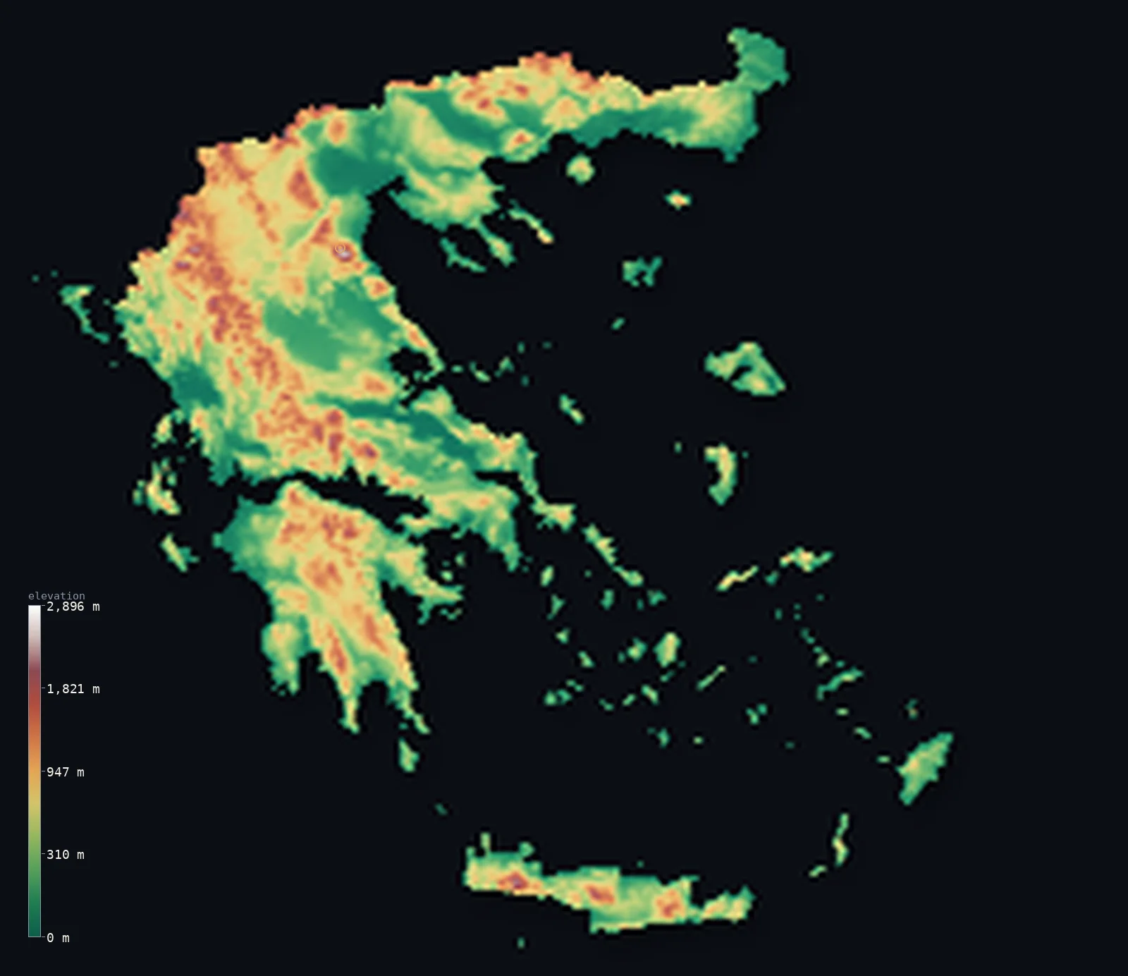
Greece’s highest point is Mount Olympus (Mytikas peak) at 9,573 ft (2,918 m); its lowest is Mediterranean Sea at 0 ft (0 m); the mean elevation is 1,578 ft (481 m).
Greece is mountains and islands. The Pindus range runs like a spine down the mainland, part of an overwhelmingly mountainous country — about 80% of Greece is upland — and where the mountains meet the sea they break into thousands of islands scattered across the Aegean and Ionian. About two-thirds of the country stands above 656 ft (200 m). The highest ground is Mount Olympus, the mythic home of the gods, reaching 9,573 ft (2,918 m) on the mainland's eastern edge.
- Highest point📚
- 9,573 ft2,918 m
- Greece's highest point is Mount Olympus at 9,573 ft (2,918 m), on the eastern edge of the mainland near the Aegean coast — a steep, many-peaked massif whose summit, Mytikas, was in myth the home of the gods. It is the highest point anywhere in Greece; none of the country's thousands of islands rises as high, the tallest of them, Crete's Psiloritis, falling several hundred metres short.
- Lowest point📚
- 0 ft0 m
- Greece's lowest point is the Mediterranean Sea at sea level, along a coastline so long and convoluted — wrapping thousands of islands and a deeply indented mainland — that it is among the longest of any country in the world relative to its size.
- Mean elevation⚙
- 1,578 ft481 m
- Computed from the GLO-30 model, Greece's mean elevation is 1,578 ft (481 m) — a high average for a country so bound to the sea, reflecting a fundamentally mountainous land: the Pindus backbone and its ranges fill the mainland, and even many of the islands are the peaks of drowned mountains.
- Median elevation⚙
- 1,201 ft366 m
- Half of Greece lies above 1,201 ft (366 m) — a high median, the mark of a genuinely mountainous country: the typical point sits well up in hill or mountain terrain, with the lowlands confined to the coastal plains, the Thessaly and Macedonia basins, and the valleys between the ranges.
- Elevation range📚
- 9,573 ft2,918 m
- From the Mediterranean to the summit of Mount Olympus, Greece spans about 9,570 ft — from sea-level island shore to the highest peak of the mainland, most of the height held in the Pindus and the ranges that branch from it.
- Above 1,000 m (3,281 ft)⚙
- 13%
- About 13% of Greece rises above 1,000 m (3,281 ft) — the Pindus range and its offshoots down the mainland, the mountains of the Peloponnese, and the higher summits of Crete. The lowlands and the smaller islands lie well below.
- Official area📚
- 50,949 mi²131,957 km²
- Greece covers about 50,900 sq mi (131,957 sq km) at the southern tip of the Balkan Peninsula, its territory split between a mountainous mainland and some 6,000 islands scattered across the Aegean and Ionian seas.
- Forest cover📚
- 30.3%
- About 30.3% of Greece is forested — pine, fir, and oak on the mountain slopes of the mainland and the larger islands, giving way to the low Mediterranean scrub of the drier lowlands and the smaller, rockier islands.
Highest and lowest points
Greece's highest point is Mount Olympus, 9,573 ft (2,918 m), near the Aegean coast on the eastern edge of the mainland — a great limestone massif of many summits, the highest of which, Mytikas, was in Greek myth the throne of Zeus and the home of the gods. It is the absolute high point of the country: despite Greece's thousands of islands, none rises as high, with Crete's Psiloritis, the tallest island peak, several hundred metres lower. Olympus was made Greece's first national park in 1938, and its upper slopes hold snow well into the warmer months.
source ↗Greece's lowest point is the Mediterranean at sea level — and no country is more defined by that sea. Greece has one of the longest coastlines in the world, wrapping a deeply indented mainland and some 6,000 islands, of which a couple of hundred are inhabited. Nowhere in the country is far from salt water; the sea divides the land into peninsulas and islands and has shaped Greek life, trade, and history for millennia. The islands themselves are mostly the tops of mountains, their lower slopes drowned beneath the Aegean and Ionian.
source ↗Greece at a glance
Mount Olympus (2,918 m), Greece's highest point, was in myth the home of the gods — and became the country's first national park in 1938.
source ↗About 80% of Greece is mountainous, dominated by the Pindus range that runs the length of the mainland.
source ↗Greece has some 6,000 islands and islets, of which only around 200 are inhabited — Crete is the largest.
source ↗Greece has one of the longest coastlines in the world — far longer than its size would suggest — because of its deeply indented mainland and thousands of islands.
source ↗The Peloponnese, the large southern peninsula, was made an island in 1893 when the Corinth Canal cut through the narrow isthmus joining it to the mainland.
source ↗The Euripus Strait, between the island of Euboea and the mainland, narrows to about 40 m and is famous for its powerful, reversing tidal currents.
source ↗
Elevation profile of Greece
The largest share of land, 34%, falls in the 0–200 m band, and 60% of the territory lies below 500 m (1,640 ft).
- below 500 m (1,640 ft)60%
- 500–1,000 m27%
- 1,000–2,000 m13%
- above 2,000 m (6,562 ft)<1%
Highest peaks of Greece
| Peak | Elevation | Range | Note |
|---|---|---|---|
| Mount Olympus (Mytikas)↗ | 9,573 ft2,918 m | Olympus massif (northern mainland) | Highest point of Greece, on the Thessaly-Macedonia regional border near the Aegean; the mythological home of the gods. |
| Smolikas↗ | 8,652 ft2,637 m | Pindus (northwest mainland) | The second-highest mountain in Greece, the high point of the Pindus range. |
| Voras (Kaimaktsalan)↗ | 8,281 ft2,524 m | Voras (North Macedonia border) | A high peak of the Voras massif on the northern border with North Macedonia. |
| Psiloritis (Mount Ida)↗ | 8,058 ft2,456 m | Crete | The highest mountain of Crete, and the tallest peak of any Greek island — still several hundred metres lower than Olympus, the country's high point. |
| Taygetus (Profitis Ilias)↗ | 7,897 ft2,407 m | Peloponnese | The highest range of the Peloponnese, a sharp pyramidal peak above Sparta. |
The mountainous mainland, the Peloponnese, and the islands
The mountainous mainland
Northern and central Greece is overwhelmingly mountainous — the Pindus range running north to south as the country's backbone, with Olympus and other high massifs branching from it, and only narrow coastal plains and interior basins (Thessaly, Macedonia) breaking the upland. This is the country's highest and most rugged ground.
The Peloponnese and the south
The large southern peninsula of the Peloponnese — joined to the mainland by the narrow Isthmus of Corinth until the canal cut it in 1893 — is itself mountainous, a knot of ranges and deep gulfs reaching toward the sea. Rugged and historic, it carries the ruins of Mycenae, Olympia, and Sparta among its hills.
The islands and coast
Where the mountains meet the sea, Greece breaks into some 6,000 islands — the Cyclades and Dodecanese scattered across the Aegean, the Ionian islands to the west, and Crete, the largest, mountainous in its own right to the south. Most are the drowned tops of mountains, rocky and steep, and it is these, with the deeply indented coast, that give Greece its vast shoreline.
How to read this map
Color shows elevation; the raised relief shows real terrain. On this map Greece reads as a mountainous mainland — browns and highs gathered along the Pindus crest and around Olympus — dissolving southward and eastward into a great scatter of islands across the Aegean, with mountainous Crete closing the south.
The 3D relief is the actual GLO-30 elevation data, exaggerated vertically so the mainland ranges and the island peaks both show; the ×N relief slider controls how much. Tap anywhere to read that point's exact elevation.
City elevations in Greece
Greek cities cluster on the coasts and the coastal plains — Athens near the southeastern tip of the mainland, Thessaloniki on the northern Aegean, Patras on the Peloponnese, with Heraklion and Chania on Crete. Few sit high; the mountains hold small towns, not large cities.
| City | Population | Elevation |
|---|---|---|
| Athenscapitalthe capital, on a coastal plain near the southeastern tip of the mainland, ringed by mountains and open to the Aegean ↗ | 664,046 | 295 ft90 m |
| Thessaloníkion the northern Aegean coast, the country's second city ↗ | 317,778 | 43 ft13 m |
| Pátra | 168,034 | 59 ft18 m |
| Lárisa | 146,926 | 253 ft77 m |
| Irákleionthe largest city of Crete, on the island's northern coast ↗ | 137,154 | 197 ft60 m |
| Ioánnina | 65,574 | 1,654 ft504 m |
| Ródos | 56,128 | 105 ft32 m |
| Kalamata | 54,100 | 89 ft27 m |
| Kavála | 54,027 | 112 ft34 m |
| Chaniá | 53,910 | 69 ft21 m |
Elevation sampled at each city centre from the Copernicus GLO-30 model. Cities and population from GeoNames (CC-BY 4.0).
Greece in comparison
Greece's terrain rises 9,573 ft (2,918 m) from sea level to Mount Olympus (Mytikas peak) — about 33% of the height of Mount Everest, the world's highest point at 29,032 ft (8,849 m).
- Italy's mean elevation is 1,814 ft — 236 ft higher; its high point, Monte Bianco (Mont Blanc), reaches 15,768 ft (4,806 m), 6,194 ft above. Italy elevation map →
- Albania's mean elevation is 2,254 ft — 676 ft higher; its high point, Mount Korab, reaches 9,068 ft (2,764 m), 505 ft below. Albania elevation map →
- Turkey's mean elevation is 3,737 ft — 2,159 ft higher; its high point, Mount Ararat (Agri Dagi), reaches 16,854 ft (5,137 m), 7,280 ft above. Turkey elevation map →
Frequently asked questions
What is the highest point in Greece?
- Mount Olympus, 9,573 ft (2,918 m), on the eastern edge of the mainland — the mythic home of the gods, and higher than any of Greece's thousands of islands.
What is the lowest point in Greece?
- The Mediterranean Sea at sea level, along one of the longest and most indented coastlines in the world.
What is the average elevation of Greece?
- Computed from the Copernicus GLO-30 model, the area-weighted mean is 1,578 ft (481 m) — high, because Greece is a fundamentally mountainous country, the Pindus backbone filling the mainland and many islands being the peaks of drowned mountains.
Is Greece mountainous?
- Very — about 80% of the country is mountainous, and the median elevation is over 360 m. The Pindus range runs down the mainland, with only coastal plains and interior basins lying low.
How many islands does Greece have?
- Around 6,000 islands and islets, of which only about 200 are inhabited. Crete is the largest, and most of the islands are the mountainous tops of a drowned landscape.
Is this a topographic, relief, contour, or elevation map of Greece?
- They describe the same thing — terrain height. This page renders the country's actual elevation surface in interactive 3D and reports the statistics computed from it.
About this map
The terrain is rendered from the Copernicus GLO-30 digital elevation model (ESA), masked to the GRC-ADM0 boundary from geoBoundaries (gbOpen). Elevation statistics are computed directly from the model; peak names and researched facts are sourced and cited. See the methodology for the full pipeline.
Our area-weighted mean, computed from the Copernicus GLO-30 model, is 1,578 ft (481 m); the figure commonly cited elsewhere is 1,634 ft (498 m) (CIA World Factbook). Greece is about four-fifths mountainous - the Pindus range forms a rugged backbone down the mainland, continuing into the Peloponnese and the islands - so the mean elevation is high for a Mediterranean country; the page reports the area-weighted figure computed from the Copernicus GLO-30 model.
Surveyed national figures: official area · forest cover · high point.
Rendered from Copernicus GLO-30 (ESA, 2021 release), boundaries from geoBoundaries. Generated 2026-07-27.
Bordering countries · 4
Greece shares a land border with these countries — open any one to compare its terrain and highest point.