Bulgaria Elevation Map — Topographic & 3D Terrain
Explore the terrain of Bulgaria in interactive 3D, built from Copernicus GLO-30 satellite elevation data — the Balkan Mountains across the middle, the highest peaks in the Balkans to the south. Drag to rotate, scroll to zoom, and tap any point to read its elevation.
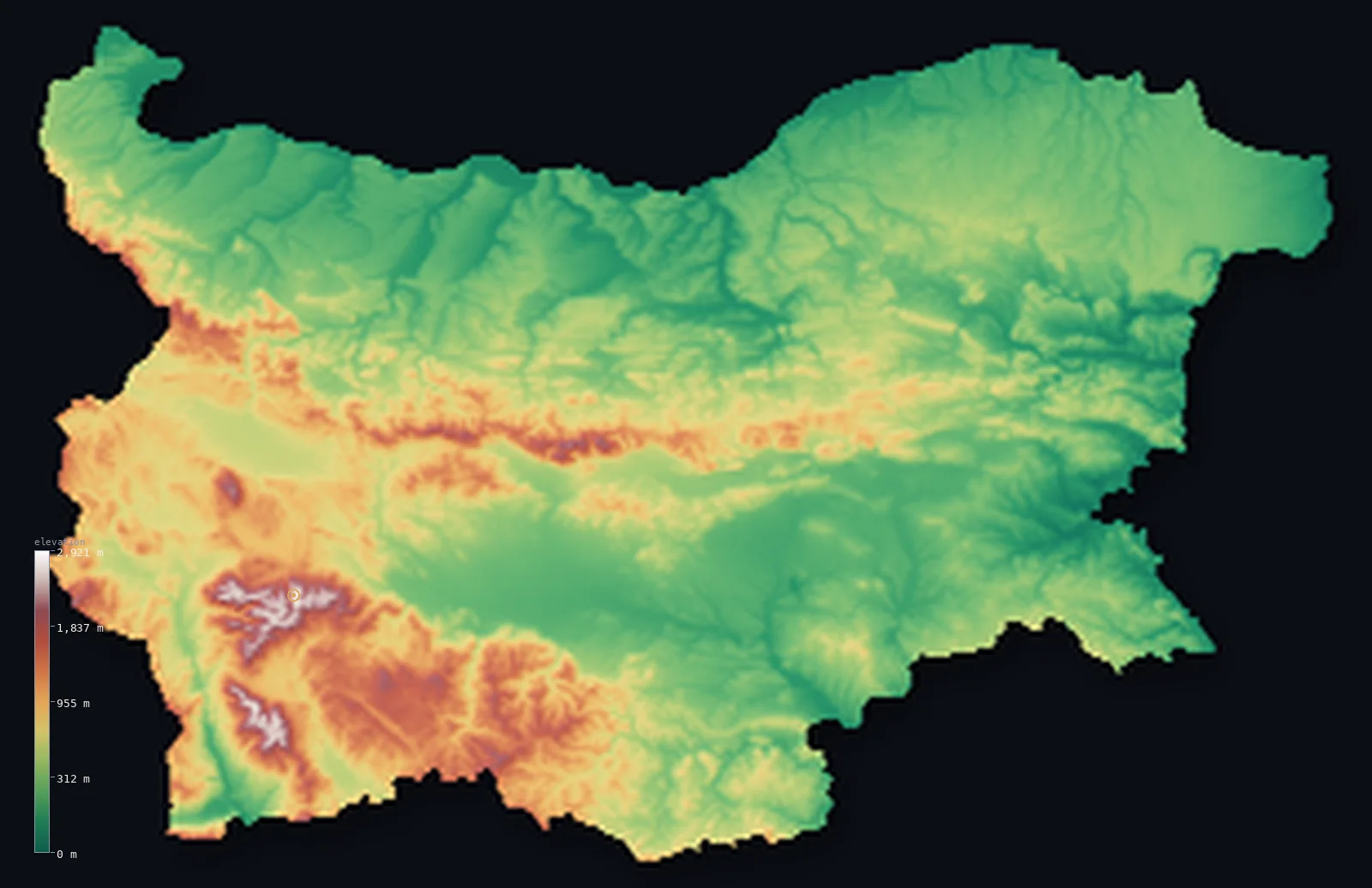
Bulgaria’s highest point is Musala at 9,596 ft (2,925 m); its lowest is Black Sea at 0 ft (0 m); the mean elevation is 1,562 ft (476 m).
Bulgaria is divided into bands by its mountains. The Balkan Mountains — the Stara Planina, which give the whole peninsula its name — run west to east straight across the middle of the country, separating the Danubian plain in the north from the Thracian plain in the south. And in the southwest rise higher ranges still: the Rila and Pirin, where Musala reaches 9,596 ft (2,925 m), the highest peak not just in Bulgaria but in the whole Balkan Peninsula. About 69% of the country stands above 656 ft (200 m).
- Highest point📚
- 9,596 ft2,925 m
- Bulgaria's highest point is Musala at 9,596 ft (2,925 m), in the Rila Mountains of the southwest — the highest peak in Bulgaria and in the entire Balkan Peninsula, a glacially-carved summit of lakes and cirques standing just above Greece's Mount Olympus, its nearest rival, a few metres to the south.
- Lowest point📚
- 0 ft0 m
- Bulgaria's lowest point is the Black Sea at sea level, on the eastern coast — the low, mild shore of a country that rises inland to the highest mountains in the Balkans.
- Mean elevation⚙
- 1,562 ft476 m
- Computed from the GLO-30 model, Bulgaria's mean elevation is 1,562 ft (476 m) — middling for a country of such contrasts, its land rising and falling in belts: up from the Danubian plain over the Balkan Mountains, down across the Thracian plain, and up again to the high Rila and Pirin of the southwest.
- Median elevation⚙
- 994 ft303 m
- Half of Bulgaria lies below 994 ft (303 m) — below the mean, because the country is banded low-high-low: the broad Danubian and Thracian plains hold most of its area down, and only the Balkan range between them and the Rila–Pirin massif in the southwest climb far above.
- Elevation range📚
- 9,596 ft2,925 m
- Bulgaria climbs about 9,600 ft from end to end — from the Black Sea coast in the east to the summit of Musala, the highest peak in the Balkans, with most of that rise packed into the Rila and Pirin of the southwest.
- Above 1,000 m (3,281 ft)⚙
- 13%
- About 13% of Bulgaria rises above 1,000 m (3,281 ft) — the crest of the Balkan Mountains across the middle and, above all, the Rila, Pirin, and Rhodope ranges of the south and southwest. The two great plains lie well below.
- Official area📚
- 42,855 mi²110,994 km²
- Bulgaria covers about 42,900 sq mi (110,994 sq km) — in the eastern Balkans, divided by the Balkan Mountains between the Danubian plain in the north and the Thracian plain in the south, with the Black Sea along its whole eastern edge.
- Forest cover📚
- 35.9%
- About 35.9% of Bulgaria is forested — much of it on the mountain ranges, the Balkan, Rila, Pirin, and Rhodope, whose slopes carry beech and conifer; the plains are more cultivated.
Highest and lowest points
Bulgaria's highest point is Musala, 9,596 ft (2,925 m), in the Rila Mountains of the southwest — and it is the highest peak not only in Bulgaria but in the whole Balkan Peninsula. Its name comes from Arabic for 'near God.' The summit is glacially sculpted, surrounded by cirques and mountain lakes, and holds snow much of the year. It stands only a few metres above its nearest rival, Mount Olympus in Greece — the two are near-twins in height at the top of the Balkans, with Musala just ahead.
source ↗Bulgaria's lowest point is the Black Sea at sea level, along the whole eastern edge of the country — a coast of long beaches, low headlands, and river mouths, milder and more open than the mountainous interior. From this shore the land rises westward through the Thracian and Danubian plains to the mountains beyond, the coast being the low, gentle edge of an otherwise upland country.
source ↗Bulgaria at a glance
Musala (2,925 m), Bulgaria's high point, is the highest peak in the entire Balkan Peninsula — standing just a few metres above its nearest rival, Greece's Mount Olympus (2,918 m).
source ↗Bulgaria is built of parallel east–west belts: the Danubian Plain, the Balkan Mountains, the Thracian Plain and the high Rila–Rhodope massif, alternating lowland and highland from north to south.
source ↗The Balkan Mountains — Stara Planina — gave the whole Balkan Peninsula its name, running clear across Bulgaria from Serbia to the Black Sea.
source ↗Under communism, Musala was renamed Stalin Peak from 1949 to 1962, before reverting to its older name after de-Stalinization.
source ↗Musala is the coldest place in Bulgaria, with an average annual temperature below freezing and snow cover lasting 8 to 9 months of the year.
source ↗The Rila Mountains hold over 200 glacial lakes, including the famous Seven Rila Lakes, and supply much of the clean drinking water for Sofia and the surrounding region.
source ↗Bulgaria's main watershed — dividing the Black Sea and Aegean drainage — runs along the Rila ridge over Musala, where the Maritsa, Iskar and Mesta rivers all rise.
source ↗
Elevation profile of Bulgaria
The largest share of land, 31%, falls in the 0–200 m band, and 67% of the territory lies below 500 m (1,640 ft).
- below 500 m (1,640 ft)67%
- 500–1,000 m21%
- 1,000–2,000 m12%
- above 2,000 m (6,562 ft)1%
Highest peaks of Bulgaria
| Peak | Elevation | Range | Note |
|---|---|---|---|
| Musala↗ | 9,596 ft2,925 m | Rila | Highest point of Bulgaria and the whole Balkan Peninsula; a granite summit in Rila National Park. |
| Vihren↗ | 9,560 ft2,914 m | Pirin | The highest peak of the Pirin Mountains and the second-highest in Bulgaria, a sharp marble pyramid. |
| Malka Musala (Little Musala)↗ | 9,521 ft2,902 m | Rila | A close neighbour of Musala in the Rila range, the third-highest peak in the country. |
| Irechek↗ | 9,357 ft2,852 m | Rila | Another high summit of East Rila near Musala, among the dozen Rila peaks over 2,700 m. |
| Botev Peak↗ | 7,795 ft2,376 m | Balkan Mountains (Stara Planina) | The highest point of the Balkan Mountains, the range that runs east–west across the centre of the country. |
Bulgaria in bands, north to south
The Balkan Mountains (Stara Planina)
The range that runs west to east across the middle of Bulgaria, dividing the country in two and giving the whole peninsula its name. Forested and of moderate height, the Stara Planina is the country's defining central range, crossed by historic passes between north and south.
The Rila, Pirin, and Rhodope (southwest and south)
The highest ground in Bulgaria — and in the Balkans — lies in the southwest: the Rila, holding Musala, and the Pirin, both glacially sculpted and lake-strewn, with the older, more rolling Rhodope reaching east along the Greek border. This is the country's alpine heart.
The Danubian plain (north)
North of the Balkan Mountains, sloping down to the Danube on the Romanian border, lies the Danubian plain — a rolling agricultural lowland, the country's northern breadbasket, drained by rivers running down to the great river.
The Thracian plain and the coast (south and east)
South of the Balkan range spreads the Thracian plain, the fertile lowland of the Maritsa valley, warm and cultivated; and along the whole east lies the Black Sea coast, the country's mild, low seaward edge.
How to read this map
Color shows elevation; the raised relief shows real terrain. On this map Bulgaria reads in bands — the ridge of the Balkan Mountains running west to east across the middle, the Danubian plain to its north and the Thracian plain to its south, and the highest ground gathered in the Rila and Pirin of the southwest, with the Black Sea along the eastern edge.
The 3D relief is the actual GLO-30 elevation data, exaggerated vertically so the central range and the southwestern high country both show; the ×N relief slider controls how much. Tap anywhere to read that point's exact elevation.
City elevations in Bulgaria
Bulgaria's cities sit mostly on the plains and in the valleys — Sofia in a high basin in the west near the mountains, Plovdiv on the Thracian plain, Varna and Burgas on the Black Sea coast, Ruse on the Danube in the north. Sofia, in its mountain-ringed basin, sits highest.
| City | Population | Elevation |
|---|---|---|
| Sofiacapitalthe capital, in a high basin in the west ringed by mountains — the highest of the country's big cities ↗ | 1,152,556 | 1,811 ft552 m |
| Plovdivon the Thracian plain in the south, on the Maritsa river ↗ | 329,489 | 528 ft161 m |
| Varnaon the Black Sea coast in the northeast ↗ | 318,737 | 223 ft68 m |
| Burgason the Black Sea coast in the southeast ↗ | 210,646 | 112 ft34 m |
| Stara Zagoraon the Thracian plain in the south-centre ↗ | 121,582 | 666 ft203 m |
| Ruseon the Danube in the north, at the Romanian border ↗ | 121,168 | 131 ft40 m |
| Plevenon the Danubian plain in the north ↗ | 90,209 | 315 ft96 m |
| Slivenat the foot of the Balkan Mountains in the south-centre ↗ | 83,740 | 889 ft271 m |
| Shumenin the northeast, near the eastern Balkan range ↗ | 72,342 | 791 ft241 m |
| Blagoevgradin the southwest, in the Struma valley between the Rila and Pirin ↗ | 67,810 | 1,253 ft382 m |
Elevation sampled at each city centre from the Copernicus GLO-30 model. Cities and population from GeoNames (CC-BY 4.0).
Bulgaria in comparison
Bulgaria's terrain rises 9,596 ft (2,925 m) from sea level to Musala — about 33% of the height of Mount Everest, the world's highest point at 29,032 ft (8,849 m).
- Romania's mean elevation is 1,312 ft — 249 ft lower; its high point, Moldoveanu, reaches 8,346 ft (2,544 m), 1,250 ft below. Romania elevation map →
- Serbia's mean elevation is 1,352 ft — 210 ft lower; its high point, Midzor, reaches 7,116 ft (2,169 m), 2,480 ft below. Serbia elevation map →
- Greece's mean elevation is 1,578 ft — 16 ft higher; its high point, Mount Olympus (Mytikas peak), reaches 9,573 ft (2,918 m), 23 ft below. Greece elevation map →
Frequently asked questions
What is the highest point in Bulgaria?
- Musala, 9,596 ft (2,925 m), in the Rila Mountains of the southwest — the highest peak in Bulgaria and in the whole Balkan Peninsula.
What is the lowest point in Bulgaria?
- The Black Sea at sea level, along the eastern coast.
What is the average elevation of Bulgaria?
- Computed from the Copernicus GLO-30 model, the area-weighted mean is 1,562 ft (476 m) — moderate, reflecting a country of mountains and plains: the Balkan range and the southwestern peaks against the Danubian and Thracian lowlands.
What is the highest mountain in the Balkans?
- Musala, in Bulgaria's Rila Mountains, at 9,596 ft (2,925 m) — just a few metres higher than Greece's Mount Olympus, its nearest rival.
How do the Balkan Mountains divide Bulgaria?
- The Stara Planina runs west to east across the middle of the country, separating the Danubian plain in the north from the Thracian plain in the south — and giving the whole peninsula its name.
Is this a topographic, relief, contour, or elevation map of Bulgaria?
- They describe the same thing — terrain height. This page renders the country's actual elevation surface in interactive 3D and reports the statistics computed from it.
About this map
The terrain is rendered from the Copernicus GLO-30 digital elevation model (ESA), masked to the BGR-ADM0 boundary from geoBoundaries (gbOpen). Elevation statistics are computed directly from the model; peak names and researched facts are sourced and cited. See the methodology for the full pipeline.
Our area-weighted mean, computed from the Copernicus GLO-30 model, is 1,562 ft (476 m); the figure commonly cited elsewhere is 1,575 ft (480 m) (Encyclopedia.com / Bulgaria geography). Bulgaria alternates lowland and highland in parallel east–west belts — the Danubian Plain, the Balkan Mountains, the Thracian Plain and the high Rila–Rhodope massif — so the mean elevation is moderate; the page reports the area-weighted figure computed from the Copernicus GLO-30 model.
Surveyed national figures: official area · forest cover · high point.
Rendered from Copernicus GLO-30 (ESA, 2021 release), boundaries from geoBoundaries. Generated 2026-06-22.
Bordering countries · 5
Bulgaria shares a land border with these countries — open any one to compare its terrain and highest point.