Romania Elevation Map — Topographic & 3D Terrain
Explore the terrain of Romania in interactive 3D, built from Copernicus GLO-30 satellite elevation data — the great arc of the Carpathians curling around the Transylvanian plateau. Drag to rotate, scroll to zoom, and tap any point to read its elevation.
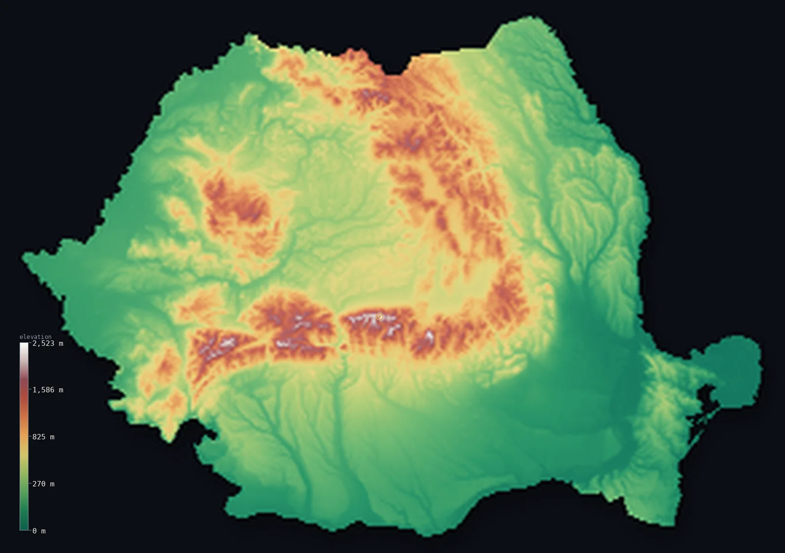
Romania’s highest point is Moldoveanu at 8,346 ft (2,544 m); its lowest is Black Sea at 0 ft (0 m); the mean elevation is 1,312 ft (400 m).
Romania is shaped like a fortress. The Carpathian Mountains sweep through the country in a great curving arc — down from the north, west through the centre, and south again — enclosing the raised Transylvanian plateau within their loop, while the plains of Wallachia and Moldavia spread beyond them to the Danube and the Black Sea. The arc rises highest in the south, in the Făgăraș range, where Moldoveanu reaches 8,346 ft (2,544 m). Beyond the mountains, the Danube gathers the country's rivers and runs east to its delta.
- Highest point📚
- 8,346 ft2,544 m
- Romania's highest point is Moldoveanu at 8,346 ft (2,544 m), in the Făgăraș Mountains of the Southern Carpathians — the high crest of the arc that curves through the country, a steep ridge of the range Romanians call the Transylvanian Alps. It is the summit of the mountain wall that encloses the Transylvanian plateau.
- Lowest point📚
- 0 ft0 m
- Romania's lowest point is the Black Sea at sea level, on the eastern coast — where the Danube, after gathering the rivers of the whole country, spreads into its great delta before reaching the sea.
- Mean elevation⚙
- 1,312 ft400 m
- Computed from the GLO-30 model, Romania's mean elevation is 1,312 ft (400 m) — a moderate figure that balances the three Romanias: the high Carpathian arc, the raised Transylvanian plateau it encloses, and the low plains that spread beyond it to the Danube.
- Median elevation⚙
- 883 ft269 m
- Half of Romania lies below 883 ft (269 m) — below the mean, the mark of a country whose lowlands, the plains of Wallachia and Moldavia, cover much of the land, with the Carpathians and the Transylvanian plateau lifting the rest.
- Elevation range📚
- 8,346 ft2,544 m
- From the Black Sea to the summit of Moldoveanu, Romania spans about 8,350 ft — most of it gained in the Carpathian arc, the mountain ring that gives the country its distinctive shape.
- Above 1,000 m (3,281 ft)⚙
- 10%
- About 10% of Romania rises above 1,000 m (3,281 ft) — the Carpathian arc, in three great sections curving through the country. The Transylvanian plateau inside the loop is lower, and the plains beyond it lower still.
- Official area📚
- 92,046 mi²238,397 km²
- Romania covers about 92,000 sq mi (238,397 sq km) — the largest country in southeastern Europe, built around the Carpathian arc, with the Danube forming much of its southern border before turning north to the Black Sea delta.
- Forest cover📚
- 30.1%
- About 30.1% of Romania is forested — much of it on the Carpathian slopes, which hold some of the largest remaining old-growth forests in Europe and a large share of the continent's brown bears; the plains and plateau are more cultivated.
Highest and lowest points
Romania's highest point is Moldoveanu, 8,346 ft (2,544 m), in the Făgăraș Mountains of the Southern Carpathians — the range sometimes called the Transylvanian Alps. It is a sharp, steep summit on the high ridge of the Făgăraș, the tallest section of the great Carpathian arc that curves through Romania. The mountains here are glacially sculpted, with cirques and ridge-line lakes, and hold snow well into the warmer months. The arc as a whole encloses the raised plateau of Transylvania within its loop — the defining structure of Romania's terrain.
source ↗Romania's lowest point is the Black Sea at sea level, on the eastern coast. Just north lies the Danube Delta — one of the largest and best-preserved river deltas in Europe, where the great river, after collecting the waters of Romania and much of central Europe, breaks into channels, reed beds, and lakes across a vast wetland before reaching the sea. It is one of the largest reed expanses in the world and a haven for birds, low and watery, at the very end of the Danube's course.
source ↗Romania at a glance
The Carpathians arc around the Transylvanian Plateau, splitting the country almost evenly into mountains, hills, and plains — the defining shape of Romania.
source ↗Romania's highest point, Moldoveanu (2,544 m), and its second-highest, Negoiu, both stand within a few kilometres on the same Făgăraș ridge — the range of the Southern Carpathians sometimes called the Transylvanian Alps.
source ↗Romania's Carpathian forests hold some of the largest remaining old-growth woodland in Europe and one of the continent's largest populations of brown bears.
source ↗The Danube Delta, where the river reaches the Black Sea in eastern Romania, is the second-largest river delta in Europe and one of the largest reed beds in the world.
source ↗The Southern Carpathians hold more than 150 glacial lakes, carved during the last ice age.
source ↗The Danube forms much of Romania's southern border before turning north through the country to its delta, gathering nearly all the country's rivers.
source ↗
Elevation profile of Romania
The largest share of land, 42%, falls in the 0–200 m band, and 71% of the territory lies below 500 m (1,640 ft).
- below 500 m (1,640 ft)71%
- 500–1,000 m19%
- 1,000–2,000 m10%
- above 2,000 m (6,562 ft)<1%
Highest peaks of Romania
| Peak | Elevation | Range | Note |
|---|---|---|---|
| Moldoveanu↗ | 8,346 ft2,544 m | Fagaras (Southern Carpathians) | Highest point of Romania, on the main ridge of the Fagaras Mountains. |
| Negoiu↗ | 8,317 ft2,535 m | Fagaras (Southern Carpathians) | The second-highest peak in Romania, also on the Fagaras ridge. |
| Parangu Mare↗ | 8,264 ft2,519 m | Parang (Southern Carpathians) | The highest peak of the Parang Mountains, west of the Fagaras. |
| Omu↗ | 8,248 ft2,514 m | Bucegi (Southern Carpathians) | The high point of the Bucegi Mountains, above the resort valleys near Brasov. |
| Peleaga↗ | 8,232 ft2,509 m | Retezat (Southern Carpathians) | The highest peak of the Retezat Mountains, a national park rich in glacial lakes. |
The arc, the plateau, and the plains
The Carpathian arc
The Carpathian Mountains curve through Romania in a great arc — the Eastern Carpathians down from the north, the Southern Carpathians (the Transylvanian Alps, holding Moldoveanu) across the centre-south, and the Western Carpathians closing the loop. Glacially sculpted and forested, they carry the country's highest ground and ring the plateau within.
The Transylvanian plateau
Enclosed within the Carpathian loop lies the plateau of Transylvania — a raised basin of hills, valleys, and farmland, higher than the plains beyond the mountains but sheltered within their ring. It is the historic heart of the country, its towns set among the hills below the encircling peaks.
The plains of Wallachia and Moldavia
Beyond the mountains to the south and east spread Romania's great lowlands — the Wallachian Plain along the Danube in the south and the plains of Moldavia to the east. Flat, fertile, and open, they are the country's agricultural heartland and hold much of its population, sloping gently toward the Danube and the sea.
The Danube and the delta
The Danube forms Romania's southern border, then turns north and east through the country before spreading into its delta on the Black Sea — a vast wetland of channels and reeds, one of the largest and best-preserved river deltas in Europe. The river gathers nearly all of Romania's waters and is the low, watery edge of the country.
How to read this map
Color shows elevation; the raised relief shows real terrain. On this map Romania's defining shape is clear — the Carpathian arc curving through the country, the raised Transylvanian plateau cradled inside its loop, and the low plains spreading beyond the mountains to the Danube and the Black Sea.
The 3D relief is the actual GLO-30 elevation data, exaggerated vertically so the mountain arc and the plateau within both show; the ×N relief slider controls how much. Tap anywhere to read that point's exact elevation.
City elevations in Romania
Romania's cities spread across its regions — Bucharest on the southern Wallachian plain, Cluj-Napoca and Brașov up in the Transylvanian basin among the mountains, Timișoara in the west, Iași and Constanța out on the eastern plains and coast. Most of the largest sit on the lowlands.
| City | Population | Elevation |
|---|---|---|
| Bucharestcapitalthe capital, on the Wallachian plain in the south, between the Carpathians and the Danube ↗ | 1,877,155 | 276 ft84 m |
| Iaşion the plains of Moldavia in the east, near the Moldovan border ↗ | 378,954 | 230 ft70 m |
| Constanţaon the Black Sea coast, near the Danube delta ↗ | 317,832 | 135 ft41 m |
| Cluj-Napocain the Transylvanian basin, ringed by the Carpathian arc ↗ | 286,598 | 1,161 ft354 m |
| Braşovin the Transylvanian basin at the foot of the Southern Carpathians — the highest of the country's big cities ↗ | 253,200 | 1,870 ft570 m |
| Timişoarain the western plains, the Banat ↗ | 250,849 | 315 ft96 m |
| Craiovaon the Wallachian plain in the southwest, in Oltenia ↗ | 234,140 | 351 ft107 m |
| Galaţion the lower Danube in the east, above the delta ↗ | 217,851 | 92 ft28 m |
| Târgu Mureşin the Transylvanian basin, on the Mureș river ↗ | 212,752 | 1,040 ft317 m |
| Oradeain the western plains near the Hungarian border, in Crișana ↗ | 183,105 | 410 ft125 m |
Elevation sampled at each city centre from the Copernicus GLO-30 model. Cities and population from GeoNames (CC-BY 4.0).
Romania in comparison
Romania's terrain rises 8,346 ft (2,544 m) from sea level to Moldoveanu — about 29% of the height of Mount Everest, the world's highest point at 29,032 ft (8,849 m).
- Bulgaria's mean elevation is 1,562 ft — 249 ft higher; its high point, Musala, reaches 9,596 ft (2,925 m), 1,250 ft above. Bulgaria elevation map →
- Hungary's mean elevation is 492 ft — 820 ft lower; its high point, Kekes, reaches 3,327 ft (1,014 m), 5,020 ft below. Hungary elevation map →
- Serbia's mean elevation is 1,352 ft — 39 ft higher; its high point, Midzor, reaches 7,116 ft (2,169 m), 1,230 ft below. Serbia elevation map →
Frequently asked questions
What is the highest point in Romania?
- Moldoveanu, 8,346 ft (2,544 m), in the Făgăraș Mountains of the Southern Carpathians — the high crest of the great Carpathian arc.
What is the lowest point in Romania?
- The Black Sea at sea level, on the eastern coast beside the Danube Delta.
What is the average elevation of Romania?
- Computed from the Copernicus GLO-30 model, the area-weighted mean is 1,312 ft (400 m) — moderate, balancing the high Carpathian arc, the raised Transylvanian plateau, and the low plains beyond.
What is the shape of Romania's terrain?
- A great arc — the Carpathian Mountains curve through the country and enclose the raised Transylvanian plateau within their loop, while the plains of Wallachia and Moldavia spread beyond them to the Danube and the Black Sea.
What is the Danube Delta?
- The wetland where the Danube reaches the Black Sea in eastern Romania — one of the largest and best-preserved river deltas in Europe, a vast expanse of channels, lakes, and reed beds, and a haven for birdlife.
Is this a topographic, relief, contour, or elevation map of Romania?
- They describe the same thing — terrain height. This page renders the country's actual elevation surface in interactive 3D and reports the statistics computed from it.
About this map
The terrain is rendered from the Copernicus GLO-30 digital elevation model (ESA), masked to the ROU-ADM0 boundary from geoBoundaries (gbOpen). Elevation statistics are computed directly from the model; peak names and researched facts are sourced and cited. See the methodology for the full pipeline.
Our area-weighted mean, computed from the Copernicus GLO-30 model, is 1,312 ft (400 m); the figure commonly cited elsewhere is 1,358 ft (414 m) (CIA World Factbook). Romania splits almost evenly into mountains, hills and plains - the Carpathian arc, the Transylvanian Plateau it encloses, and the surrounding lowlands - giving a moderate mean elevation; the page reports the area-weighted figure computed from the Copernicus GLO-30 model.
Surveyed national figures: official area · forest cover · high point.
Rendered from Copernicus GLO-30 (ESA, 2021 release), boundaries from geoBoundaries. Generated 2026-06-26.
Bordering countries · 5
Romania shares a land border with these countries — open any one to compare its terrain and highest point.