Ukraine Elevation Map — Topographic & 3D Terrain
Explore the terrain of Ukraine in interactive 3D, built from Copernicus GLO-30 satellite elevation data — a vast open steppe with mountains at two far corners. Drag to rotate, scroll to zoom, and tap any point to read its elevation.
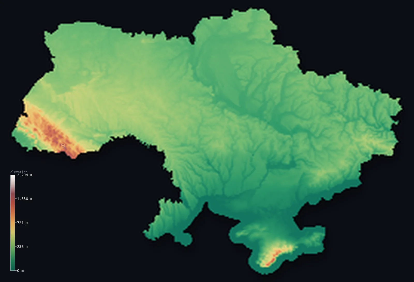
Ukraine’s highest point is Hoverla at 6,762 ft (2,061 m); its lowest is Black Sea at 0 ft (0 m); the mean elevation is 554 ft (169 m).
Ukraine is mostly open ground. The great East European Plain covers almost the whole country — rolling steppe and some of the deepest, most fertile soil on Earth — and its mountains sit only at two distant corners: the Carpathians in the far west, rising to Hoverla at 6,762 ft (2,061 m), and the Crimean Mountains along the southern coast of the peninsula. Between them stretches a thousand kilometres of plain that rarely climbs past 1,000 ft.
- Highest point📚
- 6,762 ft2,061 m
- Ukraine's highest point is Hoverla at 6,762 ft (2,061 m), in the Carpathian Mountains of the far west — a rounded, forested summit rather than a rocky peak, standing deep inside Ukrainian territory rather than on a border.
- Lowest point📚
- 0 ft0 m
- Ukraine's lowest point is the Black Sea coast at sea level, where the steppe runs out to a shoreline of shallow bays, sand spits, and river mouths.
- Mean elevation⚙
- 554 ft169 m
- Ukraine's mean elevation computed from the GLO-30 model is 554 ft (169 m) — low, and a fair account of a country that is essentially one enormous plain with mountainous ground only at its western and southern edges.
- Median elevation⚙
- 492 ft150 m
- Half of Ukraine lies below 492 ft (150 m), close to the mean — the country is remarkably even, its terrain varying by tens of metres across distances of hundreds of kilometres.
- Elevation range📚
- 6,762 ft2,061 m
- From the Black Sea shore to Hoverla, Ukraine spans about 6,760 ft — and that entire range is reached at the country's far western corner, since the plain that fills the rest barely varies.
- Above 1,000 m (3,281 ft)⚙
- 1%
- Under 1% of Ukraine rises above 1,000 m (3,281 ft) — confined to the Carpathian ridges in the west and the highest of the Crimean Mountains in the south. The rest is plain, upland, and steppe.
- Official area📚
- 233,031 mi²603,548 km²
- Ukraine covers about 233,000 sq mi (603,548 sq km) — the largest country entirely within Europe, most of it open plain.
- Forest cover📚
- 16.7%
- About 17% of Ukraine is forested — dense in the Carpathians and the northern Polissia woodlands, and thinning to almost nothing across the open steppe of the south and east, where the land has been farmed for centuries.
Highest and lowest points
Ukraine's highest point is Hoverla, 6,762 ft (2,061 m), in the Chornohora range of the Ukrainian Carpathians near the Romanian border. It is a rounded, grassy summit rather than a rocky peak — the Carpathians here are old and worn, forested nearly to the top — and unlike many national high points it stands well inside the country rather than on a frontier. It is the highest of Ukraine's few mountains, in a country where almost everything else is plain.
source ↗Ukraine's lowest point is sea level, on the Black Sea and the Sea of Azov. It is a low, gentle coast rather than a dramatic one - shallow bays, long sand spits, and the wide mouths of the Dnieper, Dniester, and Danube, where the steppe simply runs out into the water. Behind it lies the flattest country in Ukraine, the southern steppe, stretching inland with almost no change in height.
source ↗Ukraine at a glance
Ukraine's highest point, Hoverla (2,061 m), is a rounded, forested Carpathian summit - and unusually, it stands deep inside the country rather than on a border.
source ↗Ukraine is the largest country lying entirely within Europe, and almost all of it is plain.
source ↗Ukraine's steppe holds some of the world's deepest chernozem - black soil so fertile it made the country one of the great grain producers.
source ↗Under 1% of Ukraine rises above 1,000 m, and that ground sits at two far corners: the Carpathians in the west and the Crimean Mountains in the south.
source ↗The Crimean Mountains run along the southern edge of the peninsula, dropping steeply to a narrow Mediterranean-like coastal strip.
source ↗The Dnieper river runs the length of Ukraine from north to south, dividing the country and reaching the Black Sea through a broad, low estuary.
source ↗A memorial on Hoverla's summit holds soil brought from every region of Ukraine, as a symbol of the country's unity.
source ↗
Elevation profile of Ukraine
The largest share of land, 73%, falls in the 0–200 m band, and 97% of the territory lies below 500 m (1,640 ft).
- below 500 m (1,640 ft)97%
- 500–1,000 m2%
- 1,000–2,000 m1%
Highest peaks of Ukraine
| Peak | Elevation | Range | Note |
|---|---|---|---|
| Hoverla↗ | 6,762 ft2,061 m | Chornohora (Carpathians) | Highest point of Ukraine, a cone-shaped peak of the Chornohora ridge in the western Carpathians. |
| Brebeneskul↗ | 6,667 ft2,032 m | Chornohora (Carpathians) | The second-highest peak in Ukraine, a short distance along the Chornohora ridge from Hoverla. |
| Roman-Kosh↗ | 5,069 ft1,545 m | Crimean Mountains | The highest point of the Crimean Mountains in the south, along the Black Sea coast of the Crimean Peninsula. |
A plain and two mountain corners
The East European Plain
Almost all of Ukraine is plain — gently rolling farmland and open steppe stretching for hundreds of kilometres with barely any change in elevation. Its chernozem black soils are among the most fertile on Earth, and they are the reason this landscape has been farmed and fought over for centuries.
The northern woodlands and central uplands
The north is Polissia, a low, wet, wooded region of marsh and sandy soil, while across the centre run a series of gentle uplands — the Podolian and Dnieper highlands — that lift the plain by a few hundred metres without ever becoming mountains.
The Carpathians (west)
In the far west rise the Ukrainian Carpathians, forested ridges running northwest to southeast and carrying Hoverla, the country's high point. Old and rounded, they are the only substantial mountain region on the mainland.
Crimea and the southern coast
The Crimean Mountains run along the peninsula's southern edge, dropping steeply to a narrow, sheltered coastal strip, with the flat Crimean steppe spreading north behind them. Crimea has been under Russian occupation since 2014 but is internationally recognised as part of Ukraine, and is included here on that basis.
How to read this map
Color shows elevation; the raised relief shows real terrain. On this map Ukraine reads as a vast, nearly uniform green plain, with browns appearing only in the western Carpathians and along the southern edge of Crimea.
The 3D relief is the actual GLO-30 elevation data, exaggerated vertically so the plain's low undulations and the two mountain corners both show; the ×N relief slider controls how much. Tap anywhere to read that point's exact elevation.
City elevations in Ukraine
Ukraine's cities stand on the plain and the rivers - Kyiv on the hills above the Dnieper, the southern cities near the Black Sea coast. In a country this even, the difference between them is a matter of tens of metres.
| City | Population | Elevation |
|---|---|---|
| Kyivcapitalthe capital, on the hills above the Dnieper in the north-centre ↗ | 2,952,301 | 607 ft185 m |
| Kharkiv | 1,421,125 | 377 ft115 m |
| Odesaon the Black Sea coast at the southern edge of the steppe ↗ | 1,010,537 | 125 ft38 m |
| Dnipro | 968,502 | 203 ft62 m |
| Donetsk | 901,645 | 741 ft226 m |
| Lviv | 717,273 | 948 ft289 m |
| Kryvyy Rih | 603,904 | 312 ft95 m |
| Sevastopolon the southwestern coast of the Crimean Peninsula ↗ | 547,820 | 108 ft33 m |
| Mykolayiv | 470,011 | 79 ft24 m |
| Vinnytsya | 430,091 | 863 ft263 m |
Elevation sampled at each city centre from the Copernicus GLO-30 model. Cities and population from GeoNames (CC-BY 4.0).
Ukraine in comparison
Ukraine's terrain rises 6,762 ft (2,061 m) from sea level to Hoverla — about 23% of the height of Mount Everest, the world's highest point at 29,032 ft (8,849 m).
- Poland's mean elevation is 571 ft — 16 ft higher; its high point, Rysy, reaches 8,199 ft (2,499 m), 1,437 ft above. Poland elevation map →
- Romania's mean elevation is 1,312 ft — 758 ft higher; its high point, Moldoveanu, reaches 8,346 ft (2,544 m), 1,585 ft above. Romania elevation map →
- Belarus's mean elevation is 541 ft — 13 ft lower; its high point, Dzyarzhynskaya Hara, reaches 1,132 ft (345 m), 5,630 ft below. Belarus elevation map →
Frequently asked questions
What is the highest point in Ukraine?
- Hoverla, 6,762 ft (2,061 m), in the Carpathian Mountains of the far west - a rounded, forested summit standing well inside the country.
What is the lowest point in Ukraine?
- Sea level, on the Black Sea and the Sea of Azov coasts.
What is the average elevation of Ukraine?
- Computed from the Copernicus GLO-30 model, the area-weighted mean is 554 ft (169 m) - low, since almost the whole country is plain.
Does this map include Crimea?
- Yes - the boundary follows Ukraine's internationally recognised borders, which include the Crimean Peninsula, under Russian occupation since 2014.
Is Ukraine flat?
- Almost entirely - under 1% of the country rises above 1,000 m, and its only mountains are the Carpathians in the far west and the Crimean range in the south.
Is this a topographic, relief, contour, or elevation map of Ukraine?
- They describe the same thing - terrain height. This page renders the country's actual elevation surface in interactive 3D and reports the statistics computed from it.
About this map
The terrain is rendered from the Copernicus GLO-30 digital elevation model (ESA), masked to the UKR-ADM0 boundary from geoBoundaries (gbOpen). Elevation statistics are computed directly from the model; peak names and researched facts are sourced and cited. See the methodology for the full pipeline.
Our area-weighted mean, computed from the Copernicus GLO-30 model, is 554 ft (169 m); the figure commonly cited elsewhere is 574 ft (175 m) (CIA World Factbook). About 95 percent of Ukraine is flat plain and plateau on the East European Plain, with mountains only in the far west and in Crimea, so its mean elevation is low; the page reports the area-weighted figure computed from the Copernicus GLO-30 model.
Surveyed national figures: official area · forest cover · high point.
Rendered from Copernicus GLO-30 (ESA, 2021 release), boundaries from geoBoundaries. Generated 2026-07-08.
Bordering countries · 7
Ukraine shares a land border with these countries — open any one to compare its terrain and highest point.