Poland Elevation Map — Topographic & 3D Terrain
Explore the terrain of Poland in interactive 3D, built from Copernicus GLO-30 satellite elevation data — a wide northern plain that rises, at one southern corner, into the High Tatras. Drag to rotate, scroll to zoom, and tap any point to read its elevation.
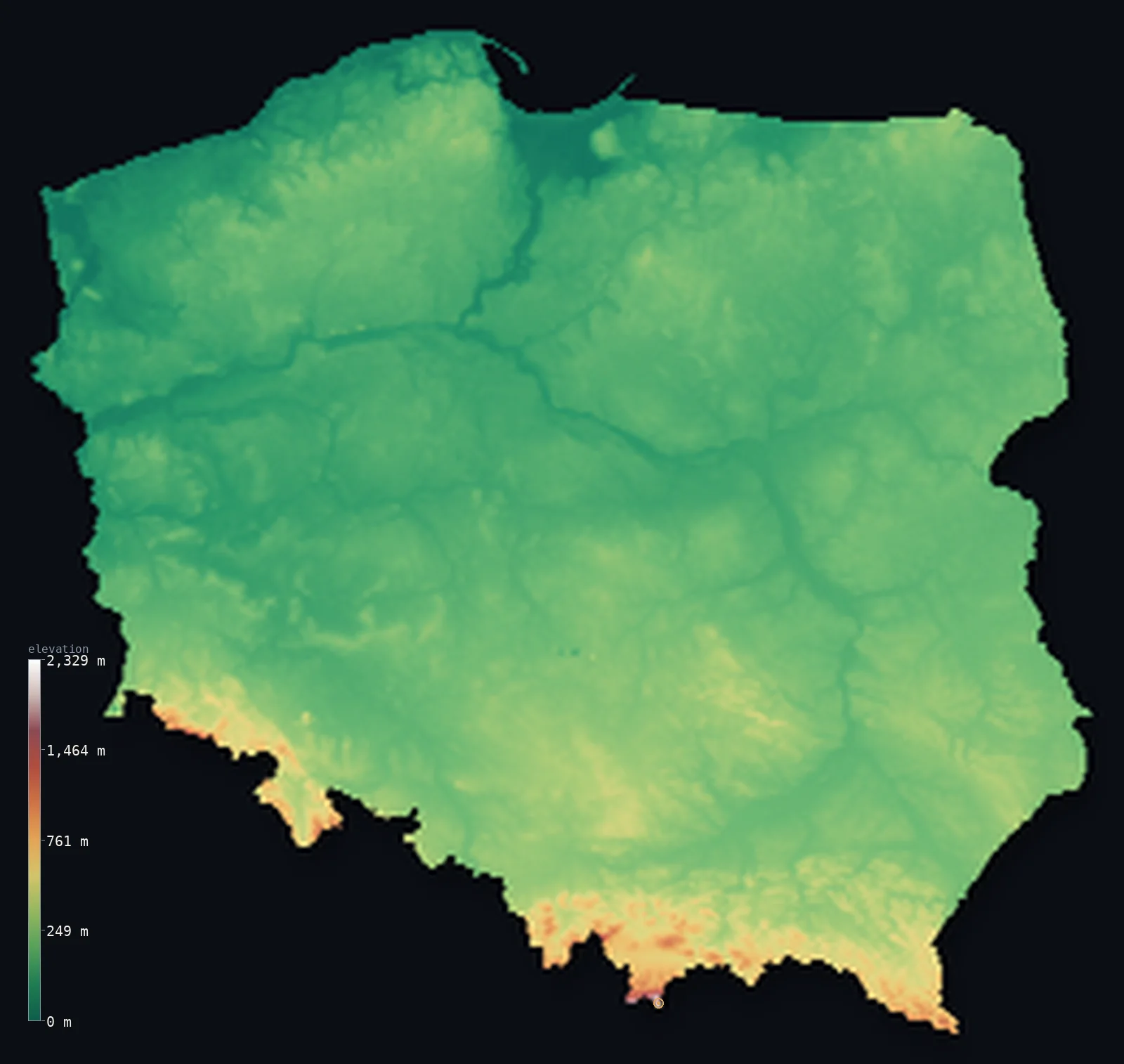
Poland’s highest point is Rysy at 8,199 ft (2,499 m); its lowest is Raczki Elblaskie at −6 ft (−1.8 m); the mean elevation is 571 ft (174 m).
Poland is a plain with a spike. Roughly three-quarters of the country lies below 328 ft (100 m) — the great North European Plain running unbroken from the Baltic to the Carpathians — and then, in one small southern corner, the land jumps: the High Tatras rise to 8,199 ft (2,499 m) at Rysy on the Slovak border. Almost nothing in between prepares you for it, and in the far north the country even dips below sea level, in the reclaimed Vistula delta.
- Highest point📚
- 8,199 ft2,499 m
- Poland's highest point is the north-western summit of Rysy at 8,199 ft (2,499 m), in the High Tatras on the border with Slovakia — and it is the lower of the mountain's tops: Rysy has three summits, and the slightly higher middle peak, 2,501 m, stands on the Slovak side.
- Lowest point📚
- −6 ft−1.8 m
- Poland's lowest point is Raczki Elbląskie in the Vistula delta, about 6 ft (1.8 m) below sea level — drained polder in the flat far north, farmed only because the water is pumped out.
- Mean elevation⚙
- 571 ft174 m
- Poland's mean elevation computed from the GLO-30 model is 571 ft (174 m) — low, and honest to the country's shape: the North European Plain covers most of it, and the mountains are confined to a narrow southern band.
- Median elevation⚙
- 482 ft147 m
- Half of Poland lies below 482 ft (147 m), close to the mean — the mark of a broadly even lowland. The Tatras are dramatic but tiny in area; they barely register in the country's overall distribution.
- Elevation range📚
- 8,205 ft2,501 m
- From the Vistula delta below sea level to the summit of Rysy, Poland spans about 8,200 ft — but nearly all of that height belongs to one small corner of the south, while the rest of the country stays within a few hundred feet of the plain.
- Above 1,000 m (3,281 ft)⚙
- <1%
- Only about <1% of Poland rises above 1,000 m (3,281 ft) — a sliver, essentially the Tatras and the highest Sudeten ridges along the southern borders.
- Official area📚
- 120,733 mi²312,696 km²
- Poland covers about 121,000 sq mi (312,696 sq km), most of it the open plain that has made the country a corridor across northern Europe for centuries.
- Forest cover📚
- 30.9%
- About 31% of Poland is forested — from the Baltic pine woods of the north to the ancient Białowieża forest on the eastern border, one of the last remnants of the primeval woodland that once covered the European plain.
Highest and lowest points
Poland's highest point is the north-western summit of Rysy, 8,199 ft (2,499 m), in the High Tatras on the Slovak border — and Poland has, in effect, the second-best of the mountain. Rysy carries three summits: the middle one, at 2,501 m, is the highest, and it lies on the Slovak side of the frontier, as does the south-eastern peak. The border runs across the massif such that Poland's highest ground is the north-western top, two metres shy of the mountain's true summit.
source ↗Poland's lowest point is at Raczki Elbląskie in Żuławy, the delta of the Vistula, about 6 ft (1.8 m) below sea level. This is reclaimed land — a low, wet delta drained from the medieval period onward and kept dry ever since by dikes, canals, and pumps. It is a small area, but it means Poland, a country best known for its plain and its mountains, also has ground beneath the level of the Baltic.
source ↗Rysy is a border summit: its peak lies about 2 km outside the generalized Poland boundary, so the highest fully in-territory land pixel in the model is 7,641 ft (2,329 m). The headline figure above is the surveyed elevation of the recognised national high point.
Poland at a glance
Poland's highest point is the north-western summit of Rysy (2,499 m) - the mountain's true summit, 2,501 m, stands two metres higher on the Slovak side of the border.
source ↗About three-quarters of Poland lies below 100 m - the country is dominated by the North European Plain, running unbroken from the Baltic coast to the southern mountains.
source ↗Poland's lowest point, in the reclaimed Vistula delta at Raczki Elbląskie, lies about 1.8 m below sea level.
source ↗The High Tatras along the Slovak border are the only genuinely alpine range in Poland, and the country's sole terrain above 2,000 m.
source ↗Białowieża Forest on Poland's eastern border is one of the last large remnants of the primeval lowland forest that once covered much of Europe.
source ↗Poland's rivers - above all the Vistula and the Oder - run northward across the plain to the Baltic, following the tilt of the whole country.
source ↗Poland has one of the highest densities of lakes in the world - in Europe only Finland has more.
source ↗
Elevation profile of Poland
The largest share of land, 74%, falls in the 0–200 m band, and 97% of the territory lies below 500 m (1,640 ft).
- below 500 m (1,640 ft)97%
- 500–1,000 m3%
- 1,000–2,000 m<1%
- above 2,000 m (6,562 ft)<1%
Highest peaks of Poland
| Peak | Elevation | Range | Note |
|---|---|---|---|
| Rysy↗ | 8,199 ft2,499 m | Tatra Mountains (Carpathians) | Highest point of Poland, a granite summit on the Slovak border in the High Tatras. |
| Kozi Wierch↗ | 7,516 ft2,291 m | Tatra Mountains (Carpathians) | The highest summit lying entirely within Poland, in the High Tatras. |
| Babia Gora↗ | 5,659 ft1,725 m | Beskids (Carpathians) | The highest peak of the Beskids, west of the Tatras near the Slovak border. |
| Sniezka↗ | 5,256 ft1,602 m | Karkonosze (Sudetes) | The highest peak of the Sudetes, on the Czech border in the southwest. |
| Lysica↗ | 2,008 ft612 m | Swietokrzyskie (Holy Cross Mountains) | The high point of the ancient, worn-down Holy Cross Mountains in central Poland. |
From the Baltic to the Tatras
The Baltic coast and northern lakes
Poland's northern edge is coastal lowland and the lake districts of Masuria and Pomerania — a landscape of moraine hills, thousands of lakes, and sandy shores left by retreating ice sheets. It holds the country's lowest ground, in the reclaimed Vistula delta.
The central plains
The middle of the country is the heart of the North European Plain — flat to gently rolling farmland crossed by the Vistula and Oder running north to the Baltic. Warsaw and most of Poland's population and agriculture sit here, rarely above 200 m.
The southern uplands
Toward the south the plain gives way to older upland — the Lesser Poland highlands and the Silesian and Lublin uplands, low plateaus and limestone hills that lift the land a few hundred metres before the mountains proper.
The Sudetes and the Carpathians
Along the southern borders rise two mountain systems: the Sudetes in the southwest, rounded and forested, and the Carpathians in the southeast, culminating in the High Tatras — a small, sharply alpine range carrying Rysy and all of Poland's ground above 2,000 m.
How to read this map
Color shows elevation; the raised relief shows real terrain. On this map Poland reads as a broad, almost uniform green plain, with browns appearing only along the southern edge and a small patch of white where the High Tatras stand.
The 3D relief is the actual GLO-30 elevation data, exaggerated vertically so the plain's gentle undulations and the abrupt southern jump both show; the ×N relief slider controls how much. Tap anywhere to read that point's exact elevation.
City elevations in Poland
Polish cities sit on the plain - Warsaw on the Vistula at about 100 m, Gdańsk on the Baltic at sea level. Only Kraków and the southern cities edge upward toward the mountains, and none of them is high.
| City | Population | Elevation |
|---|---|---|
| Warsawcapitalthe capital, on the Vistula in the central plain at about 100 m ↗ | 1,702,139 | 374 ft114 m |
| Krakówon the upper Vistula in the southern uplands, closer to the mountains ↗ | 816,614 | 728 ft222 m |
| Wrocław | 672,545 | 404 ft123 m |
| Łódź | 639,890 | 715 ft218 m |
| Poznań | 536,151 | 240 ft73 m |
| Gdańskon the Baltic coast at the Vistula's mouth, at sea level ↗ | 487,371 | 36 ft11 m |
| Szczecin | 395,513 | 95 ft29 m |
| Lublin | 336,339 | 591 ft180 m |
| Bydgoszcz | 330,038 | 131 ft40 m |
| Białystok | 295,683 | 446 ft136 m |
Elevation sampled at each city centre from the Copernicus GLO-30 model. Cities and population from GeoNames (CC-BY 4.0).
Poland in comparison
Poland's terrain rises 8,205 ft (2,501 m) from Raczki Elblaskie, 6 ft (1.8 m) below sea level to Rysy — about 28% of the height of Mount Everest, the world's highest point at 29,032 ft (8,849 m).
- Germany's mean elevation is 869 ft — 299 ft higher; its high point, Zugspitze, reaches 9,718 ft (2,962 m), 1,519 ft above. Germany elevation map →
- Czechia's mean elevation is 1,486 ft — 915 ft higher; its high point, Sněžka, reaches 5,259 ft (1,603 m), 2,940 ft below. Czechia elevation map →
- Slovakia's mean elevation is 1,496 ft — 925 ft higher; its high point, Gerlachovsky stit, reaches 8,711 ft (2,655 m), 512 ft above. Slovakia elevation map →
Frequently asked questions
What is the highest point in Poland?
- The north-western summit of Rysy, 8,199 ft (2,499 m), in the High Tatras on the Slovak border - the mountain's true summit, two metres higher, is on the Slovak side.
What is the lowest point in Poland?
- Raczki Elbląskie in the reclaimed Vistula delta, about 6 ft (1.8 m) below sea level.
What is the average elevation of Poland?
- Computed from the Copernicus GLO-30 model, the area-weighted mean is 571 ft (174 m) - low, since the North European Plain covers most of the country.
Is Poland flat or mountainous?
- Overwhelmingly flat - about three-quarters lies below 100 m. Its mountains are confined to a narrow southern band along the Czech and Slovak borders.
What are the Tatras?
- A small, sharply alpine range in the Carpathians along the Poland-Slovakia border - the only part of Poland above 2,000 m, and the site of the country's high point.
Is this a topographic, relief, contour, or elevation map of Poland?
- They describe the same thing - terrain height. This page renders the country's actual elevation surface in interactive 3D and reports the statistics computed from it.
About this map
The terrain is rendered from the Copernicus GLO-30 digital elevation model (ESA), masked to the POL-ADM0 boundary from geoBoundaries (gbOpen). Elevation statistics are computed directly from the model; peak names and researched facts are sourced and cited. See the methodology for the full pipeline.
Our area-weighted mean, computed from the Copernicus GLO-30 model, is 571 ft (174 m); the figure commonly cited elsewhere is 568 ft (173 m) (CIA World Factbook). Poland is overwhelmingly a country of the North European Plain - flat lowlands from the Baltic coast across the centre, rising only in the far south - so its mean elevation is low; the page reports the area-weighted figure computed from the Copernicus GLO-30 model. About a quarter of the country lies above this average and only a few percent above 500 m.
Surveyed national figures: official area · forest cover · high point.
Rendered from Copernicus GLO-30 (ESA, 2021 release), boundaries from geoBoundaries. Generated 2026-06-26.
Bordering countries · 7
Poland shares a land border with these countries — open any one to compare its terrain and highest point.