Lithuania Elevation Map — Topographic & 3D Terrain
Explore the terrain of Lithuania in interactive 3D, built from Copernicus GLO-30 satellite elevation data — a low, gently rolling glacial lowland on the eastern Baltic. Drag to rotate, scroll to zoom, and tap any point to read its elevation.
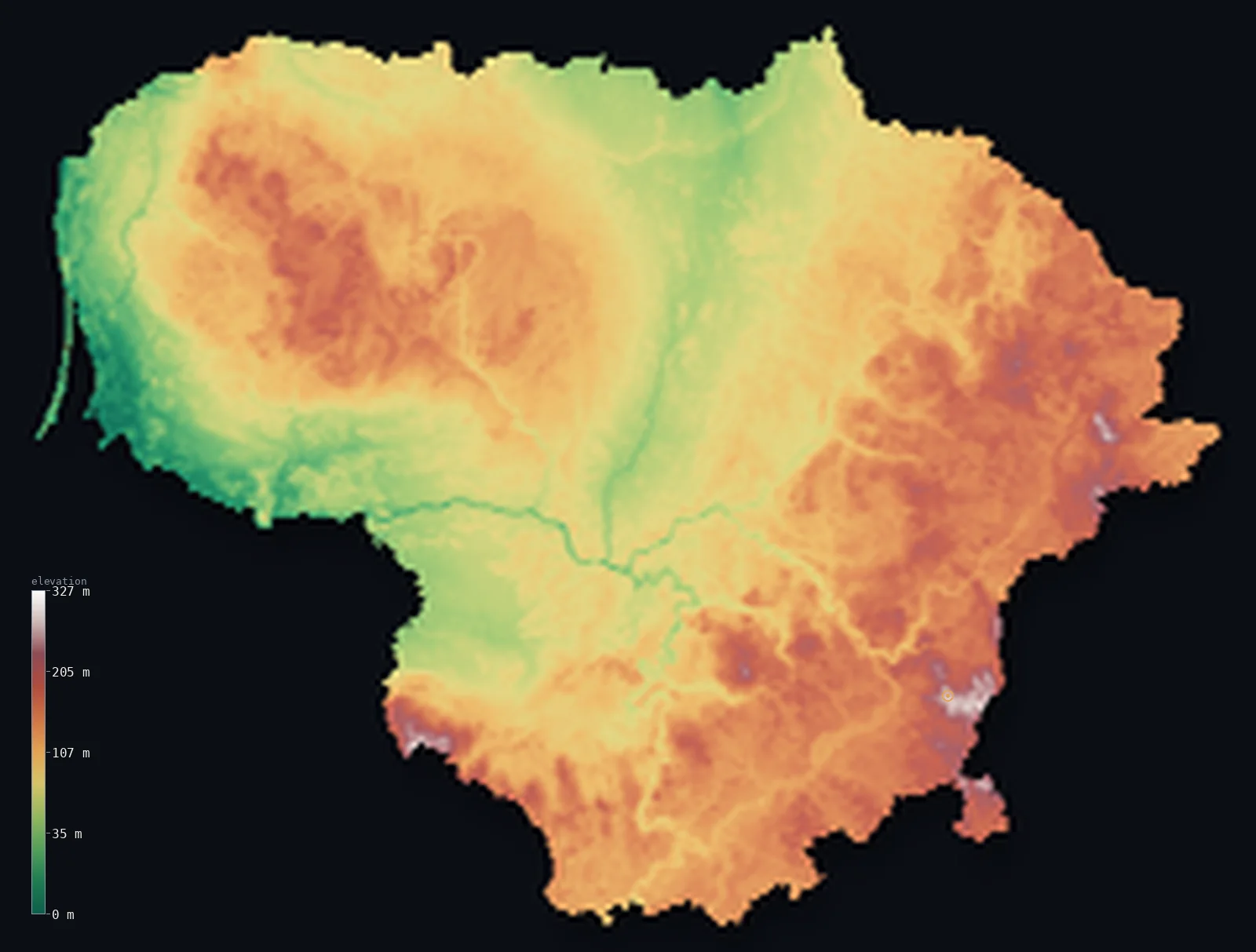
Lithuania’s highest point is Aukstojas Hill at 965 ft (294 m); its lowest is Baltic Sea at 0 ft (0 m); the mean elevation is 348 ft (106 m).
Lithuania is a low, gently rolling country on the eastern shore of the Baltic Sea. Shaped by the ice ages, it is a landscape of glacial lowland — flat coastal plains along the sea, and, inland, low ridges of glacial hills and moraine between the plains, dotted with lakes. There are no mountains and little high ground: the highest point, Aukštojas, is a wooded hill of just 965 ft (294 m) in the southeast, and most of the country lies well below that.
- Highest point📚
- 965 ft294 m
- Lithuania's highest point is Aukštojas at 965 ft (294 m), a low, forested hill in the Medininkai highlands of the southeast, near the border with Belarus. It is not a mountain but a rise in the glacial upland — so gentle and so nearly matched by its neighbour Juozapinė that its exact height was only settled by careful survey. It is the modest summit of a low country.
- Lowest point📚
- 0 ft0 m
- Lithuania's lowest point is the Baltic Sea at sea level, along the western coast — a shore of sandy beaches, dunes, and lagoons, most famously the long sandspit of the Curonian Spit that shelters a broad coastal lagoon.
- Mean elevation⚙
- 348 ft106 m
- Computed from the GLO-30 model, Lithuania's mean elevation is 348 ft (106 m) — low, the measure of a glacial lowland: flat coastal and river plains, and inland only gentle ridges of moraine and hill, with no mountains anywhere.
- Median elevation⚙
- 341 ft104 m
- Half of Lithuania lies below 341 ft (104 m) — barely above the coast, and the figure captures the country: a gently undulating glacial land where the plains and the low inland ridges differ by tens of metres, not hundreds.
- Elevation range📚
- 965 ft294 m
- From the Baltic coast to the low hill of Aukštojas, Lithuania climbs barely 965 ft in all — no mountains, just glacial lowland and the gentle moraine ridges of the east.
- Official area📚
- 25,212 mi²65,300 km²
- Lithuania covers about 25,200 sq mi (65,300 sq km) — the southernmost and largest of the three Baltic states, a low glacial lowland on the eastern Baltic coast, drained by the Nemunas river.
- Forest cover📚
- 35%
- About 35.0% of Lithuania is forested — roughly a third of the country, in pine, spruce, and birch woodland scattered across the plains and the sandier soils, with large forests in the south and the coastal region.
Highest and lowest points
Lithuania's highest point is Aukštojas, 965 ft (294 m), a low, wooded hill in the Medininkai highlands of the southeast, near the Belarusian border. It is barely a hill by the standards of most countries, and its status is a curiosity: it stands only a metre or two above its immediate neighbour Juozapinė, long thought to be the highest, and Aukštojas was confirmed as the true summit only after precise modern measurement. The 'highlands' here are a low rise of glacial moraine — the modest roof of a country with no mountains and very little high ground at all.
source ↗Lithuania's lowest point is the Baltic Sea at sea level, along a western coast of beaches, dunes, and lagoons. Its most striking feature is the Curonian Spit — a long, narrow sandspit of high dunes, partly forested, running for tens of kilometres to enclose the shallow Curonian Lagoon, where the Nemunas river, which drains most of the country, reaches the sea. The coast is low and sandy, the seaward edge of a low country.
source ↗Lithuania at a glance
Lithuania's highest point changed in 2004: a GPS survey found Aukstojas Hill (293.84 m) to be just over a metre higher than nearby Juozapine Hill, the long-assumed summit 500 m away.
source ↗Nowhere in Lithuania reaches 300 m above sea level - it is one of the flattest countries in Europe, shaped entirely by Ice Age glaciers.
source ↗The country is dotted with about 2,800 lakes larger than a hectare, most of them in the eastern highlands.
source ↗The Curonian Spit - a 98 km dune barrier shared with Russia - shelters the Curonian Lagoon, into which the Nemunas River empties before reaching the Baltic.
source ↗Aukstojas Hill is named for Aukstejas, a supreme creator deity of ancient Lithuanian (Baltic) mythology.
source ↗By some reckonings the geographical centre of Europe lies just north of Vilnius, in Lithuania's southeast.
source ↗
Elevation profile of Lithuania
The largest share of land, 15%, falls in the 60–80 m band, and 100% of the territory lies below 500 m (1,640 ft).
- below 500 m (1,640 ft)100%
Highest peaks of Lithuania
| Peak | Elevation | Range | Note |
|---|---|---|---|
| Aukstojas Hill↗ | 965 ft294 m | Medininkai Highlands (southeast) | Highest point of Lithuania, a moraine hill confirmed highest by a 2004 GPS survey. |
| Juozapine Hill↗ | 961 ft293 m | Medininkai Highlands (southeast) | About 500 m from Aukstojas and just over a metre lower; it was regarded as the country's highest point until 2004. |
| Medvegalis↗ | 768 ft234 m | Samogitian Upland (west) | A landmark hill of the western Samogitian (Zemaitija) Upland, long significant in Lithuanian history. |
Lithuania: coastal plains, inland ridges, and lake country
The coastal and central lowlands
Western and central Lithuania is low plain — the flat Baltic coast with its dunes and lagoons, and inland the broad central lowland of the Nemunas and its tributaries, fertile and gently level. This is the country's lowest, flattest ground.
The eastern and southern highlands
Eastern and southeastern Lithuania is gently higher — low ridges of glacial hills and moraine, the Baltic and Medininkai highlands, holding Aukštojas and most of the country's many lakes. 'Highlands' only by local measure, they rise a couple of hundred metres, not more.
The lakes and glacial country
Across the higher east lie Lithuania's lakes — thousands of them, set in the glacial landscape of hills, moraine, and forest left by the retreating ice. Low, wooded, and watery, it is the most varied terrain in an otherwise low country.
How to read this map
Color shows elevation; the raised relief shows real terrain. On this map Lithuania reads almost entirely in low greens — the flat coastal and central plains in the west, rising gently to the slightly higher ridges and lake country of the east and southeast, where Aukštojas sits.
The 3D relief is the actual GLO-30 elevation data, exaggerated vertically so that a country this low and gently rolling shows any shape at all; the ×N relief slider controls how much. Tap anywhere to read that point's exact elevation.
City elevations in Lithuania
Lithuania's cities sit on the plains and rivers — Vilnius in the southeast among the low hills, Kaunas where the Nemunas and Neris meet in the centre, Klaipėda on the Baltic coast, Šiauliai and Panevėžys on the northern plain. All sit low, in a low country.
| City | Population | Elevation |
|---|---|---|
| Vilniuscapitalthe capital, in the southeast among the low glacial hills ↗ | 542,366 | 335 ft102 m |
| Kaunasin the centre, at the meeting of the Nemunas and Neris rivers ↗ | 289,380 | 226 ft69 m |
| Klaipėdaon the Baltic coast by the Curonian Lagoon, the main port ↗ | 172,292 | 30 ft9 m |
| Šiauliaion the northern plain ↗ | 99,462 | 430 ft131 m |
| Panevėžyson the northern plain, on the Nevėžis ↗ | 85,885 | 194 ft59 m |
| Alytusin the south, on the Nemunas ↗ | 49,195 | 312 ft95 m |
| Sovetsk | 43,309 | 49 ft15 m |
| Marijampolėin the southwest, near the Polish border ↗ | 34,975 | 233 ft71 m |
| Mazeikiaiin the northwest, near the Latvian border ↗ | 32,470 | 233 ft71 m |
| Jonavain the centre, on the Neris near Kaunas ↗ | 26,423 | 230 ft70 m |
Elevation sampled at each city centre from the Copernicus GLO-30 model. Cities and population from GeoNames (CC-BY 4.0).
Lithuania in comparison
Lithuania's terrain rises 965 ft (294 m) from sea level to Aukstojas Hill — about 3% of the height of Mount Everest, the world's highest point at 29,032 ft (8,849 m).
- Latvia's mean elevation is 299 ft — 49 ft lower; its high point, Gaizinkalns, reaches 1,024 ft (312 m), 59 ft above. Latvia elevation map →
- Poland's mean elevation is 571 ft — 223 ft higher; its high point, Rysy, reaches 8,199 ft (2,499 m), 7,234 ft above. Poland elevation map →
- Belarus's mean elevation is 541 ft — 194 ft higher; its high point, Dzyarzhynskaya Hara, reaches 1,132 ft (345 m), 167 ft above. Belarus elevation map →
Frequently asked questions
What is the highest point in Lithuania?
- Aukštojas, 965 ft (294 m), a low wooded hill in the southeast — not a mountain but a rise in the glacial upland, confirmed the highest only by precise survey over its neighbour Juozapinė.
What is the lowest point in Lithuania?
- The Baltic Sea at sea level, along the western coast of beaches, dunes, and the Curonian Lagoon.
What is the average elevation of Lithuania?
- Computed from the Copernicus GLO-30 model, the area-weighted mean is 348 ft (106 m) — low, because Lithuania is a glacial lowland of plains and gently rolling terrain, with no mountains.
Is Lithuania flat?
- Largely — it is a low glacial lowland of coastal and river plains and gently rolling inland ridges, with no mountains and a highest point of just 294 m. The east and southeast are slightly higher, rolling hill and lake country.
What is the Curonian Spit?
- A long, narrow forested sandspit of high dunes on Lithuania's Baltic coast, enclosing the shallow Curonian Lagoon — a UNESCO World Heritage Site, and one of the country's most distinctive landscapes.
Is this a topographic, relief, contour, or elevation map of Lithuania?
- They describe the same thing — terrain height. This page renders the country's actual elevation surface in interactive 3D and reports the statistics computed from it.
About this map
The terrain is rendered from the Copernicus GLO-30 digital elevation model (ESA), masked to the LTU-ADM0 boundary from geoBoundaries (gbOpen). Elevation statistics are computed directly from the model; peak names and researched facts are sourced and cited. See the methodology for the full pipeline.
Our area-weighted mean, computed from the Copernicus GLO-30 model, is 348 ft (106 m); the figure commonly cited elsewhere is 361 ft (110 m) (CIA World Factbook). Lithuania is a glacial lowland of plains and gentle moraine hills with no true mountains - maximum elevations barely exceed 290 m - so its mean elevation is low; the page reports the area-weighted figure computed from the Copernicus GLO-30 model.
Surveyed national figures: official area · forest cover · high point.
Rendered from Copernicus GLO-30 (ESA, 2021 release), boundaries from geoBoundaries. Generated 2026-06-23.
Bordering countries · 4
Lithuania shares a land border with these countries — open any one to compare its terrain and highest point.