Latvia Elevation Map — Topographic & 3D Terrain
Explore the terrain of Latvia in interactive 3D, built from Copernicus GLO-30 satellite elevation data — a low, forested glacial plain on the Baltic, threaded by the Daugava and the Gauja. Drag to rotate, scroll to zoom, and tap any point to read its elevation.
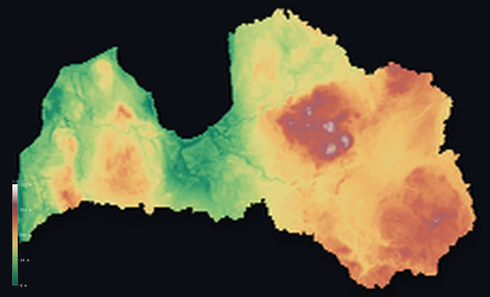
Latvia’s highest point is Gaizinkalns at 1,024 ft (312 m); its lowest is Baltic Sea at 0 ft (0 m); the mean elevation is 299 ft (91 m).
Latvia is a low, densely forested plain on the eastern Baltic. Even flatter than its neighbours, it is a country of glacial lowland — broad coastal and river plains, low rolling uplands inland, and forest covering more than half the land. There are no mountains: the highest point, Gaiziņkalns, is a wooded hill of just 1,024 ft (312 m), and most of the country lies far below. The rivers Daugava and Gauja wind across it to the Gulf of Riga.
- Highest point📚
- 1,024 ft312 m
- Latvia's highest point is Gaiziņkalns at 1,024 ft (312 m), a low, forested hill in the Vidzeme uplands of the country's east-centre — the highest of a gently rolling glacial upland, crowned by a lookout tower, since the hill itself barely lifts above the surrounding wooded country. It is the modest summit of a low, flat land.
- Lowest point📚
- 0 ft0 m
- Latvia's lowest point is the Baltic Sea at sea level, along the western and northern coasts — including the deep inlet of the Gulf of Riga, on which the capital stands. The coast is low and sandy, fringed in places with dunes and pine forest.
- Mean elevation⚙
- 299 ft91 m
- Computed from the GLO-30 model, Latvia's mean elevation is 299 ft (91 m) — very low, among the lowest in the region: Latvia is a broad glacial plain of coastal and river lowland and gently rolling wooded upland, forest over more than half of it and no high ground at all.
- Median elevation⚙
- 299 ft91 m
- Half of Latvia lies below 299 ft (91 m) — lower than Lithuania's but above Estonia's, the middle of the flat Baltic trio: a broad glacial plain where the wooded uplands rise only tens of metres above the river valleys.
- Elevation range📚
- 1,024 ft312 m
- Only about 1,025 ft separates Latvia's lowest ground from its highest, the Baltic coast from the wooded rise of Gaiziņkalns — a tiny span, all glacial plain and low upland, without a mountain anywhere.
- Official area📚
- 24,938 mi²64,589 km²
- Latvia covers about 24,900 sq mi (64,589 sq km) — the central of the three Baltic states, a low, forested glacial plain on the Baltic coast, drained by the Daugava and the Gauja.
- Forest cover📚
- 54.9%
- About 54.9% of Latvia is forested — more than half the country, among the most forested in Europe: extensive pine, spruce, and birch woodland across the plains and uplands, a defining feature of the Latvian landscape.
Highest and lowest points
Latvia's highest point is Gaiziņkalns, 1,024 ft (312 m), a low, wooded hill in the Vidzeme uplands of the east-centre. Like the high points of its Baltic neighbours, it is a hill rather than a mountain — a rise in the gently rolling glacial upland, so modest that a lookout tower was built on top to see over the surrounding forest. It is the highest of the Vidzeme highlands, the most elevated of Latvia's several low upland regions, and the roof of a country that is otherwise broad, low, forested plain.
source ↗Latvia's lowest point is the Baltic Sea at sea level, along a coast that runs from the open Baltic in the west round into the Gulf of Riga, the broad inlet on which the capital, Riga, stands at the mouth of the Daugava. The coast is low, sandy, and often pine-fringed, with long beaches and dunes. Behind it the land rises only gently: Latvia is a low country, and much of it, near the coast and along the rivers, lies barely above the sea.
source ↗Latvia at a glance
Latvia's highest point, Gaizinkalns, is only 312 m - and an unfinished tower was once built on it specifically to out-top Estonia's slightly higher Suur Munamagi (318 m).
source ↗About 98% of Latvia lies below 200 m elevation - it is one of Europe's flattest countries.
source ↗More than half of Latvia is forested, and its forest area has roughly doubled over the past century.
source ↗Latvia holds over 12,000 rivers and more than 3,000 lakes, almost all shaped by Ice Age glaciation.
source ↗Gaizinkalns is geologically a pile of glacial debris over 16,000 years old, capped by a clay layer nearly 30 m thick.
source ↗Decades as a closed Soviet border zone left about 300 km of Latvia's coast undeveloped - one of the wildest shorelines in Europe.
source ↗
Elevation profile of Latvia
The largest share of land, 16%, falls in the 100–120 m band, and 100% of the territory lies below 500 m (1,640 ft).
- below 500 m (1,640 ft)100%
Highest peaks of Latvia
| Peak | Elevation | Range | Note |
|---|---|---|---|
| Gaizinkalns↗ | 1,024 ft312 m | Vidzeme Upland (central) | The highest point of Latvia, a glacial-moraine hill in the central Vidzeme Upland with small ski slopes. |
| Lielais Liepukalns↗ | 948 ft289 m | Latgale Upland (southeast) | The highest hill of eastern Latvia, in the lake-strewn Latgale Upland. |
| Krievukalns↗ | 620 ft189 m | Kurzeme Upland (west) | The high point of the western Kurzeme (Courland) Upland, a moraine rise. |
Latvia: lowland plains, rolling uplands, and forest
The coastal and central lowlands
Western Latvia and the centre are low plain — the flat Baltic coast and the Gulf of Riga, and inland the broad central lowland of the Daugava and other rivers. Flat, fertile, and low, it is the country's most extensive and lowest ground.
The rolling uplands (Vidzeme and Latgale)
Inland, to the east, the land rises into low rolling uplands — the Vidzeme highlands, holding Gaiziņkalns, and the Latgale uplands further southeast. Gently hilly, wooded, and dotted with lakes, they are 'uplands' only by the flat standards of the country, rising a few hundred metres at most.
The forests and river valleys
Forest covers more than half of Latvia, across both the lowlands and the uplands, and among it wind the country's rivers — above all the Daugava and the scenic Gauja, the latter in a valley of sandstone cliffs and caves. Low, wooded, and watery, it is the characteristic Latvian landscape.
How to read this map
Color shows elevation; the raised relief shows real terrain. On this map Latvia reads almost entirely in low greens — the broad flat coastal and central plains, rising very gently to the low rolling uplands of the east and southeast where Gaiziņkalns sits.
The 3D relief is the actual GLO-30 elevation data, exaggerated vertically so that a country this low and flat shows any shape at all; the ×N relief slider controls how much. Tap anywhere to read that point's exact elevation.
City elevations in Latvia
Latvia's cities sit low, on the coast and the rivers — Riga on the Gulf of Riga at the mouth of the Daugava, Daugavpils upriver in the southeast, Liepāja and Ventspils on the western Baltic coast, Jelgava on the central plain. All lie in low country.
| City | Population | Elevation |
|---|---|---|
| Rigacapitalthe capital, on the Gulf of Riga at the mouth of the Daugava ↗ | 742,572 | 16 ft5 m |
| Daugavpilsin the southeast, upriver on the Daugava ↗ | 78,126 | 344 ft105 m |
| Liepājaon the western Baltic coast ↗ | 67,421 | 26 ft8 m |
| Jelgavaon the central Zemgale plain, south of Riga ↗ | 54,834 | 23 ft7 m |
| Ventspilson the northwestern Baltic coast, a major port ↗ | 32,723 | 26 ft8 m |
| Rēzeknein the eastern Latgale uplands ↗ | 26,429 | 522 ft159 m |
| Valmierain the northeast, on the Gauja in Vidzeme ↗ | 22,812 | 148 ft45 m |
| Ogreon the Daugava southeast of Riga ↗ | 22,767 | 115 ft35 m |
| Jēkabpilson the Daugava in the southeast ↗ | 21,014 | 279 ft85 m |
| Tukumswest of Riga, toward the coast ↗ | 16,182 | 210 ft64 m |
Elevation sampled at each city centre from the Copernicus GLO-30 model. Cities and population from GeoNames (CC-BY 4.0).
Latvia in comparison
Latvia's terrain rises 1,024 ft (312 m) from sea level to Gaizinkalns — about 4% of the height of Mount Everest, the world's highest point at 29,032 ft (8,849 m).
- Estonia's mean elevation is 187 ft — 112 ft lower; its high point, Suur Munamagi, reaches 1,043 ft (318 m), 20 ft above. Estonia elevation map →
- Lithuania's mean elevation is 348 ft — 49 ft higher; its high point, Aukstojas Hill, reaches 965 ft (294 m), 59 ft below. Lithuania elevation map →
- Belarus's mean elevation is 541 ft — 243 ft higher; its high point, Dzyarzhynskaya Hara, reaches 1,132 ft (345 m), 108 ft above. Belarus elevation map →
Frequently asked questions
What is the highest point in Latvia?
- Gaiziņkalns, 1,024 ft (312 m), a low wooded hill in the Vidzeme uplands — a rise in the glacial upland rather than a mountain, crowned by a lookout tower to see over the forest.
What is the lowest point in Latvia?
- The Baltic Sea at sea level, along the western and northern coasts, including the Gulf of Riga on which the capital stands.
What is the average elevation of Latvia?
- Computed from the Copernicus GLO-30 model, the area-weighted mean is 299 ft (91 m) — very low, because Latvia is a broad glacial plain of lowland and gently rolling wooded uplands, with no mountains.
Is Latvia flat?
- Very — it is one of the flatter countries in the region, a low glacial plain with a highest point of just 312 m. The interior has low rolling uplands, but more than half the country is forested lowland.
How forested is Latvia?
- More than half the country is forest — among the most forested in Europe — extensive pine, spruce, and birch woodland covering both the lowland plains and the rolling uplands.
Is this a topographic, relief, contour, or elevation map of Latvia?
- They describe the same thing — terrain height. This page renders the country's actual elevation surface in interactive 3D and reports the statistics computed from it.
About this map
The terrain is rendered from the Copernicus GLO-30 digital elevation model (ESA), masked to the LVA-ADM0 boundary from geoBoundaries (gbOpen). Elevation statistics are computed directly from the model; peak names and researched facts are sourced and cited. See the methodology for the full pipeline.
Our area-weighted mean, computed from the Copernicus GLO-30 model, is 299 ft (91 m); the figure commonly cited elsewhere is 285 ft (87 m) (CIA World Factbook). Latvia is a low country of glacial plains and gently rolling moraine uplands - about 98% lies below 200 m - so its mean elevation is very low; the page reports the area-weighted figure computed from the Copernicus GLO-30 model.
Surveyed national figures: official area · forest cover · high point.
Rendered from Copernicus GLO-30 (ESA, 2021 release), boundaries from geoBoundaries. Generated 2026-06-23.
Bordering countries · 4
Latvia shares a land border with these countries — open any one to compare its terrain and highest point.