Estonia Elevation Map — Topographic & 3D Terrain
Explore the terrain of Estonia in interactive 3D, built from Copernicus GLO-30 satellite elevation data — a low Baltic country of forest, bog, and more than 2,200 islands. Drag to rotate, scroll to zoom, and tap any point to read its elevation.
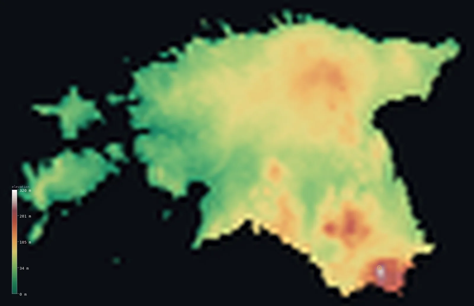
Estonia’s highest point is Suur Munamagi at 1,043 ft (318 m); its lowest is Baltic Sea at 0 ft (0 m); the mean elevation is 187 ft (57 m).
Estonia is the flattest of the three Baltic states — and yet it holds their highest point. A low platform of limestone and glacial deposits on the eastern Baltic, barely lifted above the sea, it is a land of forest, bog, lake, and more than 2,200 islands, the largest of them Saaremaa and Hiiumaa. Its mean elevation, just 187 ft (57 m), is among the lowest in Europe. But in the far southeast the ground rises into the low Haanja hills, and one of them — Suur Munamägi, 1,043 ft (318 m) — is higher than anything in Latvia or Lithuania.
- Highest point📚
- 1,043 ft318 m
- Estonia's highest point is Suur Munamägi at 1,043 ft (318 m) — and although Estonia is the flattest of the three Baltic states, this is the highest ground in all of them, topping anything in Latvia or Lithuania. It rises in the Haanja country of the far southeast, a gentle wooded rise crowned by a 29-metre observation tower — built, like the towers on several Estonian 'mountains', to see out over the forest, with views up to 50 km on a clear day.
- Lowest point📚
- 0 ft0 m
- Estonia's lowest point is the Baltic Sea at sea level — but its coast is unlike its southern neighbours': long, shallow, and deeply indented, fringed by more than 2,200 islands, chief among them Saaremaa and Hiiumaa off the western shore. Along parts of the northern coast the land ends in the low limestone bluffs of the North Estonian Klint.
- Mean elevation⚙
- 187 ft57 m
- Computed from the GLO-30 model, Estonia's mean elevation is 187 ft (57 m) — the lowest of the three Baltic states, and lower than almost any country in Europe. Estonia is a flat platform of limestone and glacial deposits barely lifted above the sea, its relief confined to a few low uplands in the southeast.
- Median elevation⚙
- 177 ft54 m
- Half of Estonia lies below just 177 ft (54 m) — the lowest midpoint of any Baltic state, and one of the lowest in Europe. Most of the country is a level plain of forest, bog, and farmland on flat-lying limestone; only in the far southeast does the ground gather into low hills.
- Elevation range📚
- 1,043 ft318 m
- Estonia's whole vertical range is just 1,043 ft, sea level to the crest of Suur Munamägi — and small as that is, it is the greatest relief of any Baltic state. The country is nearly all low plain and island; its one patch of real high ground, the Haanja upland in the southeast, carries hills that top not only Estonia but Latvia and Lithuania too.
- Official area📚
- 17,505 mi²45,339 km²
- Estonia covers about 17,500 sq mi (45,339 sq km) — a small country on the eastern Baltic, between Latvia and the Gulf of Finland, made up of a low mainland plain and more than 2,200 islands, the largest of them Saaremaa and Hiiumaa off the western coast.
- Forest cover📚
- 47%
- About 47% of Estonia is forested — nearly half the country, in a landscape where low forest, bog, and lake count for far more than height. Pine, spruce, and birch cover mainland and islands alike, threaded with extensive raised bogs and mires.
Highest and lowest points
Estonia's highest point is Suur Munamägi, 1,043 ft (318 m), in the Haanja uplands of the far southeast near the Latvian and Russian borders — the only part of Estonia with any real relief. Modest as it is, it is the highest point not only of Estonia but of all three Baltic states, topping Latvia's Gaiziņkalns (312 m) and Lithuania's Aukštojas (294 m). Its natural summit carries a 29.1-metre observation tower, built so visitors can see over the surrounding forest — a fittingly Estonian touch, as several of the country's 'hills' need a tower to be seen at all.
source ↗Estonia's lowest point is the Baltic Sea at sea level, along a coastline that is one of the country's defining features: long, shallow, and deeply indented, running some 3,800 km including the shores of more than 2,200 islands. The two largest, Saaremaa and Hiiumaa, lie off the western coast; Saaremaa holds the Kaali meteorite craters. Parts of the northern shore are edged by the North Estonian Klint, a low limestone escarpment on which Tallinn's old town sits at Toompea.
source ↗Estonia at a glance
Suur Munamagi (318 m) is not only Estonia's highest point but the highest in all three Baltic states - higher than anything in Latvia or Lithuania.
source ↗Estonia is so flat that many of its 'mountains' carry observation towers to see over the forest - Suur Munamagi's 29.1 m tower gives views up to 50 km on a clear day.
source ↗The capital's old town sits on Toompea, a limestone hill just 62 m high on the North Estonian Klint - one of the country's more prominent natural rises.
source ↗Estonia has more than 1,400 lakes and over 2,200 islands - water and low forest define the landscape far more than height.
source ↗The island of Saaremaa holds the Kaali craters, a cluster of meteorite-impact craters that may have been witnessed by Iron Age inhabitants.
source ↗Lake Peipus, forming much of Estonia's border with Russia, is one of the largest lakes in Europe.
source ↗
Elevation profile of Estonia
The largest share of land, 24%, falls in the 40–60 m band, and 100% of the territory lies below 500 m (1,640 ft).
- below 500 m (1,640 ft)100%
Highest peaks of Estonia
| Peak | Elevation | Range | Note |
|---|---|---|---|
| Suur Munamagi↗ | 1,043 ft318 m | Haanja Upland | Highest point of Estonia and the Baltic states, a glacial hill crowned by an observation tower. |
| Vallamagi↗ | 997 ft304 m | Haanja Upland | The second-highest hill in Estonia, also in the Haanja Upland of the southeast. |
| Kuutsemagi↗ | 712 ft217 m | Otepaa Upland | The high point of the Otepaa Upland, a glacial-hill district and winter-sports area. |
Estonia: the low plains, the southeastern hills, and the islands
The low plains, lakes, and klint
Most of Estonia is a low, flat plain on ancient flat-lying limestone, averaging little more than 50 m above the sea — forest, bog, and farmland threaded with over 1,400 lakes, including Lake Peipus on the Russian border, one of Europe's largest. Along the north coast the plain ends in the North Estonian Klint, a low limestone escarpment on which Tallinn's old town stands at Toompea.
The southeastern uplands (Haanja)
Estonia's only real relief lies in the southeast, where Ice Age glaciers piled up low moraine hills — the Haanja upland, holding Suur Munamägi (318 m), the highest point of all three Baltic states. Even here the hills are gentle and forested, several of them topped with observation towers to see out over the trees.
The coast and the western islands
Estonia's long, shallow Baltic coastline is deeply indented and fringed by more than 2,200 islands. The two largest, Saaremaa and Hiiumaa, lie off the western shore, low and wooded; Saaremaa holds the Kaali meteorite craters. Water and island define Estonia far more than height.
How to read this map
Color shows elevation; the raised relief shows real terrain. On this map Estonia reads as a low green platform edged by sea and island — flat almost everywhere, with the mainland and the western islands of Saaremaa and Hiiumaa barely above the water, and the only real rise the low Haanja hills in the far southeast around Suur Munamägi.
The 3D relief is the actual GLO-30 elevation data, exaggerated vertically so that a country this flat shows its shape; the ×N relief slider controls how much. Tap anywhere to read that point's exact elevation.
City elevations in Estonia
Estonia's towns sit low and near water — Tallinn on the north coast, Pärnu on the southwest, Narva on the eastern river border, Tartu inland on the Emajõgi, and Kuressaare out on the island of Saaremaa. Only Viljandi and Võru, in the south, sit on any notable rise; the rest are barely above the sea.
| City | Population | Elevation |
|---|---|---|
| Tallinncapitalthe capital, on the north coast, its old town on the Toompea limestone hill of the klint ↗ | 394,024 | 39 ft12 m |
| Tartuin the southeast on the Emajõgi River, the main inland city ↗ | 91,407 | 131 ft40 m |
| Narvain the far northeast on the Russian border, on the Narva River ↗ | 54,409 | 95 ft29 m |
| Pärnuon the southwest coast, a low-lying seaside city on the Gulf of Riga ↗ | 40,228 | 23 ft7 m |
| Kohtla-Järvein the northeast, in the oil-shale mining region ↗ | 35,395 | 210 ft64 m |
| Viljandiin the south, on higher ground above its lake ↗ | 17,407 | 266 ft81 m |
| Rakverein the north, inland from the coast ↗ | 14,984 | 253 ft77 m |
| Kuressaareon the island of Saaremaa, the main town of the western islands ↗ | 12,698 | 30 ft9 m |
| Võruin the far southeast, near the Haanja uplands and Suur Munamägi ↗ | 12,367 | 246 ft75 m |
| Valgain the south on the Latvian border, a town split between the two countries ↗ | 11,792 | 210 ft64 m |
Elevation sampled at each city centre from the Copernicus GLO-30 model. Cities and population from GeoNames (CC-BY 4.0).
Estonia in comparison
Estonia's terrain rises 1,043 ft (318 m) from sea level to Suur Munamagi — about 4% of the height of Mount Everest, the world's highest point at 29,032 ft (8,849 m).
- Latvia's mean elevation is 299 ft — 112 ft higher; its high point, Gaizinkalns, reaches 1,024 ft (312 m), 20 ft below. Latvia elevation map →
- Finland's mean elevation is 515 ft — 328 ft higher; its high point, Halti (Halditsohkka), reaches 4,344 ft (1,324 m), 3,301 ft above. Finland elevation map →
- Lithuania's mean elevation is 348 ft — 161 ft higher; its high point, Aukstojas Hill, reaches 965 ft (294 m), 79 ft below. Lithuania elevation map →
Frequently asked questions
What is the highest point in Estonia?
- Suur Munamägi, 1,043 ft (318 m), a forested hill in the Haanja uplands of the southeast — the highest point not just of Estonia but of all three Baltic states. It is topped by a 29-metre observation tower.
What is the lowest point in Estonia?
- The Baltic Sea at sea level, along a long, shallow, deeply indented coast fringed by more than 2,200 islands, the largest Saaremaa and Hiiumaa.
What is the average elevation of Estonia?
- Computed from the Copernicus GLO-30 model, the area-weighted mean is 187 ft (57 m) — the lowest of the three Baltic states and one of the lowest in Europe, as Estonia is a flat platform barely above the sea.
Is Estonia flat?
- Very — it is the flattest of the Baltic states, half of it below 54 m, mostly level plain, forest, bog, and island. Its only real relief is the low Haanja upland in the southeast, which nonetheless holds the highest hill in all three Baltic states.
How many islands does Estonia have?
- More than 2,200, along its long, shallow Baltic coast. The two largest, Saaremaa and Hiiumaa, lie off the western shore; Saaremaa holds the Kaali meteorite-impact craters.
Is this a topographic, relief, contour, or elevation map of Estonia?
- They describe the same thing — terrain height. This page renders the country's actual elevation surface in interactive 3D and reports the statistics computed from it.
About this map
The terrain is rendered from the Copernicus GLO-30 digital elevation model (ESA), masked to the EST-ADM0 boundary from geoBoundaries (gbOpen). Elevation statistics are computed directly from the model; peak names and researched facts are sourced and cited. See the methodology for the full pipeline.
Our area-weighted mean, computed from the Copernicus GLO-30 model, is 187 ft (57 m); the figure commonly cited elsewhere is 200 ft (61 m) (CIA World Factbook). Estonia is exceptionally flat: half the country lies below 54 m and its highest point reaches only 318 m, so its area-weighted mean is very low. The figure computed here from the Copernicus GLO-30 model, about 57 m, sits just below the 61 m commonly cited by the CIA World Factbook (older references give figures nearer 50 m).
Surveyed national figures: official area · forest cover · high point.
Rendered from Copernicus GLO-30 (ESA, 2021 release), boundaries from geoBoundaries. Generated 2026-07-29.
Bordering countries · 2
Estonia shares a land border with these countries — open any one to compare its terrain and highest point.