Russia Elevation Map — Topographic & 3D Terrain
Explore the terrain of Russia in interactive 3D, built from Copernicus GLO-30 satellite elevation data — the largest country on Earth, and one of the flattest. Drag to rotate, scroll to zoom, and tap any point to read its elevation.
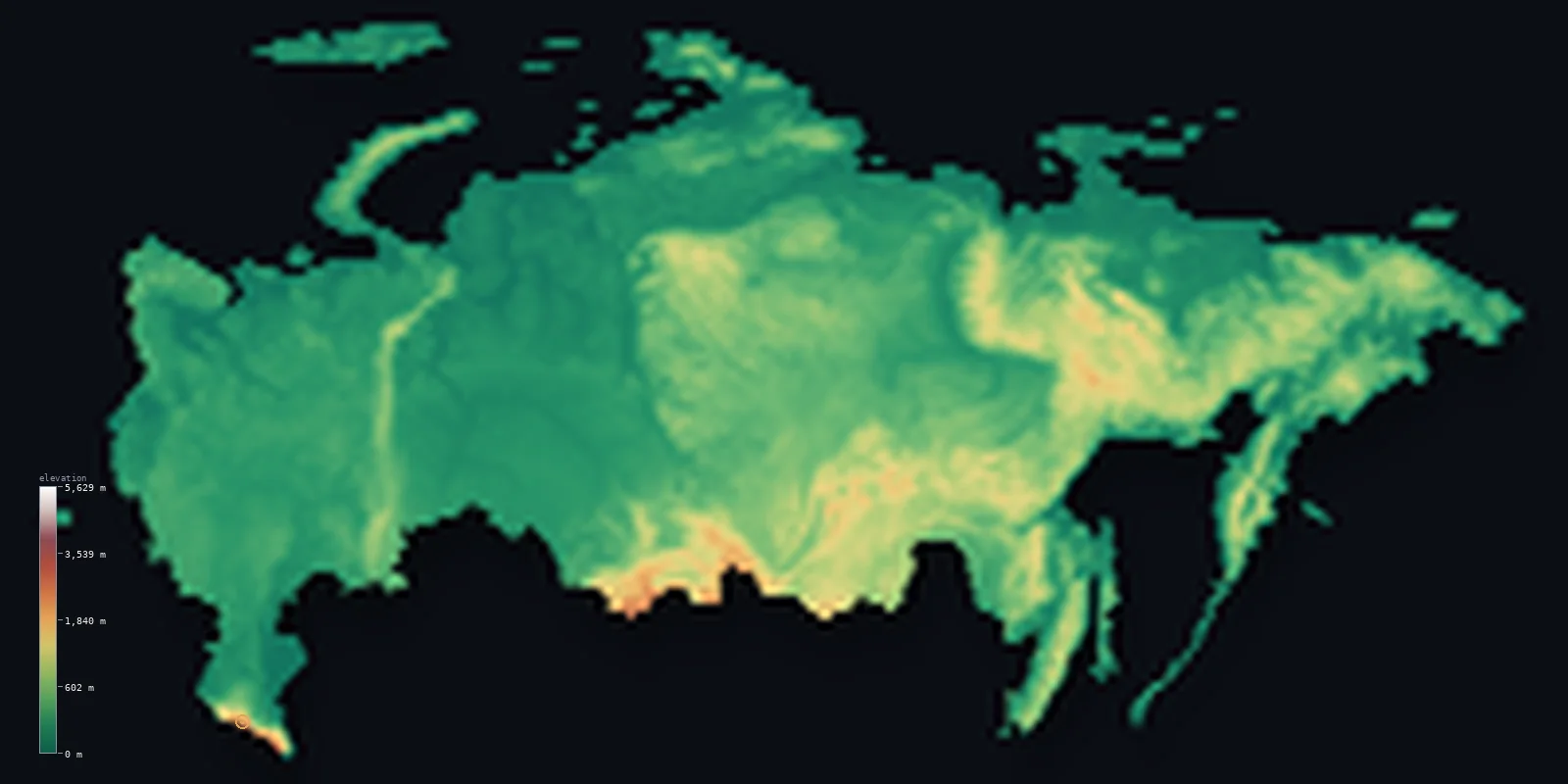
Russia’s highest point is Mount Elbrus at 18,510 ft (5,642 m); its lowest is Caspian Sea at −92 ft (−28 m); the mean elevation is 1,148 ft (350 m).
The largest country on Earth is also, for its size, remarkably flat. About 76% of Russia lies below 500 m (1,640 ft) — an immense plain running from the Baltic across the Urals and on through the West Siberian lowland, one of the largest areas of level ground anywhere. The mountains are pushed to the southern and eastern edges, where Mount Elbrus rises to 18,510 ft (5,642 m) in the Caucasus.
- Highest point📚
- 18,510 ft5,642 m
- Russia's highest point is Mount Elbrus at 18,510 ft (5,642 m), a dormant twin-coned volcano in the Caucasus of the far southwest — the highest mountain in Europe by the usual continental boundary, and far higher than anything in the country's vast interior.
- Lowest point📚
- −92 ft−28 m
- Russia's lowest point is the shore of the Caspian Sea, 92 ft (28 m) below sea level — the Caspian being the largest inland body of water on Earth, and its surface sitting well beneath the level of the oceans.
- Mean elevation⚙
- 1,148 ft350 m
- Russia's mean elevation computed from the GLO-30 model is just 1,148 ft (350 m) — strikingly low for the world's largest country, because the great plains of European Russia and West Siberia occupy so enormous a share of it.
- Median elevation⚙
- 650 ft198 m
- Half of Russia lies below 650 ft (198 m) — an extraordinary statistic for a country spanning eleven time zones, and a measure of just how much of it is flat, low, and continuous.
- Elevation range📚
- 18,602 ft5,670 m
- From the Caspian shore below sea level to the summit of Elbrus, Russia spans about 18,600 ft — but the climb happens almost entirely in the far south and east; across thousands of kilometres of the interior, the land barely changes height at all.
- Above 1,000 m (3,281 ft)⚙
- 8%
- Only about 8% of Russia rises above 1,000 m (3,281 ft) — the Caucasus in the southwest, the Altai and Sayan in the south, and the ranges of the Far East and Kamchatka. The Urals, for all their fame as a continental divide, rarely top 1,500 m.
- Official area📚
- 6,601,665 mi²17,098,242 km²
- Russia covers about 6.6 million sq mi (17.1 million sq km) — by far the largest country on Earth, stretching across eleven time zones from the Baltic to the Pacific and crossing the antimeridian in the far northeast.
- Forest cover📚
- 49.8%
- About 50% of Russia is forested — the taiga, the largest continuous forest on the planet, belting the country from the western border to the Pacific across the low ground of Siberia.
Highest and lowest points
Russia's highest point is Mount Elbrus, 18,510 ft (5,642 m), a dormant volcano with twin summits in the Caucasus range near the Georgian border. By the conventional boundary that places the Caucasus crest in Europe, it is the highest mountain in Europe — and it stands far above anything else in Russia, which otherwise has no peak over 5,300 m. It lies within the country's interior rather than on a shared summit.
source ↗Russia's lowest point is the Caspian Sea shore, 92 ft (28 m) below sea level, in the flat Caspian Depression north of the sea. The Caspian is the largest enclosed body of water on Earth, and because it has no outlet to the ocean its surface sits far below sea level — so the surrounding steppe, some of the emptiest land in European Russia, lies beneath the tide.
source ↗Russia at a glance
Mount Elbrus, 5,642 m, is Russia's highest point and - by the usual continental boundary - the highest mountain in Europe.
source ↗Despite being the largest country on Earth, about 76% of Russia lies below 500 m - dominated by two immense plains.
source ↗The West Siberian Plain is one of the largest areas of continuous flat land in the world, so level that it drains into vast swamps.
source ↗Russia's lowest point is the Caspian shore at 28 m below sea level - the Caspian is the largest inland body of water on Earth and has no outlet to the ocean.
source ↗The Ural Mountains, the traditional divide between Europe and Asia, are old and low - rarely exceeding 1,500 m.
source ↗Kamchatka in the Far East holds dozens of active volcanoes, including Klyuchevskaya Sopka at about 4,750 m - the highest active volcano in Eurasia.
source ↗
Elevation profile of Russia
The largest share of land, 76%, falls in the 0–500 m band, and 76% of the territory lies below 500 m (1,640 ft).
- below 500 m (1,640 ft)76%
- 500–1,000 m16%
- 1,000–2,000 m7%
- above 2,000 m (6,562 ft)1%
Highest peaks of Russia
| Peak | Elevation | Range | Note |
|---|---|---|---|
| Mount Elbrus↗ | 18,510 ft5,642 m | Caucasus | Highest point of Russia and of Europe, a dormant volcano in the Caucasus. |
| Dykh-Tau↗ | 17,077 ft5,205 m | Caucasus | The second-highest peak in Russia, in the central Caucasus of Kabardino-Balkaria. |
| Kazbek↗ | 16,512 ft5,033 m | Caucasus | A great Caucasus volcano on the border between Russia and Georgia. |
| Klyuchevskaya Sopka↗ | 15,584 ft4,750 m | Kamchatka | The highest active volcano in Eurasia and the highest peak of the Russian Far East, in Kamchatka. |
| Mount Belukha↗ | 14,783 ft4,506 m | Altai | The highest peak of Siberia's Altai Mountains, near the Kazakh border. |
Russia's great divisions
The western plains and the Urals
European Russia is one enormous plain, rolling gently from the Baltic to the Ural Mountains — and the Urals themselves, though they mark the traditional divide between Europe and Asia, are old, worn, and rarely above 1,500 m, more a long ridge than a barrier.
Siberia
East of the Urals lies the West Siberian Plain, one of the flattest and largest lowlands on Earth, so level it drains into immense swamps; beyond it the land rises gradually into the Central Siberian Plateau. Across all of it stretches the taiga, the world's largest forest.
The southern mountains and the Far East
Russia's high ground is confined to its rim — the Caucasus in the southwest with Elbrus, the Altai and Sayan along the Mongolian border, and the ranges of the Far East, ending in volcanic Kamchatka with its dozens of active cones.
How to read this map
Color shows elevation; the raised relief shows real terrain. On this map Russia reads as an enormous low green-and-brown expanse, with sharper high ground only at the southern and eastern edges.
The 3D relief is the actual GLO-30 elevation data, exaggerated vertically so the vast plains still show shape; the ×N relief slider controls how much. Tap anywhere to read that point's exact elevation.
City elevations in Russia
Russian cities sit low almost everywhere - St Petersburg at the head of the Baltic barely above sea level, Moscow on gentle hills of the Russian Plain at about 150 m. Across the whole immense country, there is very little high ground for a city to stand on.
| City | Population | Elevation |
|---|---|---|
| Moscowcapitalthe capital, on low hills of the Russian Plain at about 150 m ↗ | 10,381,222 | 499 ft152 m |
| Saint Petersburgat the head of the Gulf of Finland on flat delta ground, barely above sea level ↗ | 5,351,935 | 23 ft7 m |
| Novosibirsk | 1,612,833 | 423 ft129 m |
| Yekaterinburg | 1,495,066 | 876 ft267 m |
| Nizhniy Novgorod | 1,259,013 | 459 ft140 m |
| Kazan | 1,243,500 | 213 ft65 m |
| Chelyabinsk | 1,202,371 | 725 ft221 m |
| Omsk | 1,172,070 | 295 ft90 m |
| Samara | 1,163,399 | 285 ft87 m |
| Rostov-on-Don | 1,130,305 | 128 ft39 m |
Elevation sampled at each city centre from the Copernicus GLO-30 model. Cities and population from GeoNames (CC-BY 4.0).
Russia in comparison
Russia's terrain rises 18,602 ft (5,670 m) from Caspian Sea, 92 ft (28 m) below sea level to Mount Elbrus — about 64% of the height of Mount Everest, the world's highest point at 29,032 ft (8,849 m).
- Kazakhstan's mean elevation is 1,178 ft — 30 ft higher; its high point, Khan Tengri, reaches 22,999 ft (7,010 m), 4,488 ft above. Kazakhstan elevation map →
- China's mean elevation is 6,014 ft — 4,865 ft higher; its high point, Mount Everest (Qomolangma), reaches 29,032 ft (8,849 m), 10,522 ft above. China elevation map →
- Mongolia's mean elevation is 4,875 ft — 3,727 ft higher; its high point, Khuiten Peak, reaches 14,350 ft (4,374 m), 4,160 ft below. Mongolia elevation map →
Frequently asked questions
What is the highest point in Russia?
- Mount Elbrus, 18,510 ft (5,642 m), a dormant volcano in the Caucasus - and by the usual continental boundary, the highest mountain in Europe.
What is the lowest point in Russia?
- The Caspian Sea shore, 92 ft (28 m) below sea level - the Caspian is the world's largest inland body of water and lies well beneath ocean level.
What is the average elevation of Russia?
- Computed from the Copernicus GLO-30 model, the area-weighted mean is 1,148 ft (350 m) - low for the world's largest country, because immense plains cover most of it.
Is Russia flat?
- Mostly, yes - about 76% lies below 500 m. The European plain and the West Siberian Plain together form one of the largest areas of level ground on Earth, with mountains only along the southern and eastern rims.
How high are the Ural Mountains?
- Low - the Urals rarely exceed 1,500 m. They are ancient and worn, and mark the traditional divide between Europe and Asia more by convention than by height.
Is this a topographic, relief, contour, or elevation map of Russia?
- They describe the same thing - terrain height. This page renders the country's actual elevation surface in interactive 3D and reports the statistics computed from it.
About this map
The terrain is rendered from the Copernicus GLO-30 digital elevation model (ESA), masked to the RUS-ADM0 boundary from geoBoundaries (gbOpen). Elevation statistics are computed directly from the model; peak names and researched facts are sourced and cited. See the methodology for the full pipeline.
This map renders 18,177,634 km² across 79 landmasses of Russia. One smaller outlying part — 1,857 km² in total — lies beyond the area shown here. Area statistics above count the full territory.
Because Russia covers 18,177,634 km², its 3D terrain surface is rendered at roughly 6.7 km per pixel rather than the model’s native 30 m — the full-resolution grid exceeds the render budget for an area this large. The high point and every elevation figure on this page are still measured at native 30 m resolution; only the rendered surface detail is coarsened.
Our area-weighted mean, computed from the Copernicus GLO-30 model, is 1,148 ft (350 m); no authority publishes a mean elevation (No authoritative published mean elevation). No standard source publishes a single mean elevation for Russia, by far the largest country on Earth, spanning vast plains and high southern and eastern mountains. The page reports the area-weighted figure computed from the Copernicus GLO-30 model, shown at reduced surface resolution for a country this large.
Surveyed national figures: official area · forest cover · high point.
Rendered from Copernicus GLO-30 (ESA, 2021 release), boundaries from geoBoundaries. Generated 2026-07-10.
Bordering countries · 14
Russia shares a land border with these countries — open any one to compare its terrain and highest point.
- Azerbaijan↑ Mount Bazardüzü, 4,466 m
- Belarus↑ Dzyarzhynskaya Hara, 345 m
- China↑ Mount Everest (Qomolangma), 8,849 m
- Estonia↑ Suur Munamagi, 318 m
- Finland↑ Halti (Halditsohkka), 1,324 m
- Georgia↑ Shkhara, 5,193 m
- Kazakhstan↑ Khan Tengri, 7,010 m
- Latvia↑ Gaizinkalns, 312 m
- Lithuania↑ Aukstojas Hill, 294 m
- Mongolia↑ Khuiten Peak, 4,374 m
- North Korea↑ Paektu (Janggun Peak), 2,744 m
- Norway↑ Galdhopiggen, 2,469 m
- Poland↑ Rysy, 2,499 m
- Ukraine↑ Hoverla, 2,061 m