Norway Elevation Map — Topographic & 3D Terrain
Explore the terrain of Norway in interactive 3D, built from Copernicus GLO-30 satellite elevation data — a mountain country drowned along its edge, cut into fjords by ice. Drag to rotate, scroll to zoom, and tap any point to read its elevation.
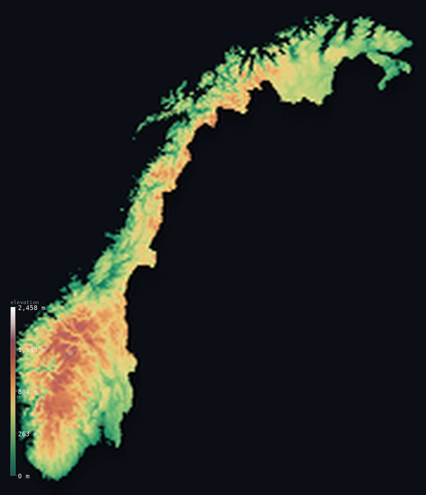
Norway’s highest point is Galdhopiggen at 8,100 ft (2,469 m); its lowest is Norwegian Sea at 0 ft (0 m); the mean elevation is 1,831 ft (558 m).
Norway is a high country that meets the sea abruptly. Its mountainous spine — the Scandinavian range — runs the length of the mainland, but glaciers cut the western edge into fjords so deep that the ocean reaches far inland between walls of rock. The result is a country that is both high and coastal at once: 52% of it lies below 1,640 ft (500 m), yet the land rises to 8,100 ft (2,469 m) at Galdhøpiggen, and almost nowhere is far from salt water.
- Highest point📚
- 8,100 ft2,469 m
- Norway's highest point is Galdhøpiggen at 8,100 ft (2,469 m), in the Jotunheimen range of the southern mainland — the highest summit in Norway and in all of Northern Europe, standing among the country's largest glaciers.
- Lowest point📚
- 0 ft0 m
- Norway's lowest point is sea level — but that says little in a country whose coast is cut by fjords running up to 200 km inland, where deep salt water lies directly beneath mountain walls more than a kilometre high.
- Mean elevation⚙
- 1,831 ft558 m
- Norway's mean elevation computed from the GLO-30 model is 1,831 ft (558 m) for the mapped mainland — high for a coastal country, because the Scandinavian mountains occupy so much of it and the fjords, though deep, are narrow.
- Median elevation⚙
- 1,568 ft478 m
- Half of the Norwegian mainland lies above 1,568 ft (478 m) — remarkably high given how maritime the country is, and a measure of how the plateaus and mountains fill the interior while the population clings to the fjord shores below.
- Elevation range📚
- 8,100 ft2,469 m
- From the fjord waters at sea level to Galdhøpiggen, mainland Norway spans about 8,100 ft — and much of that rise happens within a few kilometres, since the mountains drop almost directly into the sea along the western coast.
- Above 1,000 m (3,281 ft)⚙
- 15%
- About 15% of mainland Norway rises above 1,000 m (3,281 ft) — the high plateaus and the Jotunheimen and Dovre ranges of the south, along with the mountains of the far north, above the tree line and often under permanent snow.
- Official area📚
- 148,729 mi²385,207 km²
- The Kingdom of Norway covers about 148,700 sq mi (385,207 sq km), but much of that is Svalbard and Jan Mayen in the Arctic; the mainland shown on this map is about 124,750 sq mi (323,098 sq km) — still long enough that it reaches from the latitude of Scotland to well beyond the Arctic Circle.
- Forest cover📚
- 27.8%
- About 28% of Norway is forested — spruce and pine across the lower southeast and the valleys, thinning fast with height and latitude until, on the high plateaus and in the far north, the trees stop altogether.
Highest and lowest points
Norway's highest point is Galdhøpiggen, 8,100 ft (2,469 m), in the Jotunheimen range of southern Norway — the highest mountain in Norway and in Northern Europe as a whole. It stands among the country's largest glaciers, and its neighbour Glittertind is only a few metres lower, the two having traded the title as Glittertind's summit ice has thinned. The Arctic territory of Svalbard lies outside this map, and its highest peak is lower.
source ↗Norway's lowest point is sea level, but the way the sea meets the land here is unlike anywhere else in Europe. Glaciers of the last ice age gouged the western coast into fjords — long, narrow inlets where deep water runs up to 200 km inland beneath cliffs rising more than 1,000 m straight from the surface. The country's low point is therefore everywhere and nowhere: the ocean is threaded right through the mountains.
source ↗Norway at a glance
Galdhøpiggen, 2,469 m, is the highest mountain in Norway and in all of Northern Europe.
source ↗Norway's western coast is cut by fjords - glacier-carved inlets where deep sea water runs up to 200 km inland beneath cliffs over 1,000 m high.
source ↗The Norwegian mainland stretches from the latitude of Scotland to far beyond the Arctic Circle, so long that the far north sees months of continuous daylight and darkness.
source ↗Norway's coastline, counting the fjords and tens of thousands of islands, is one of the longest in the world relative to the country's size.
source ↗Much of interior Norway is high plateau - the vidde - above the tree line, including Hardangervidda, the largest mountain plateau in Europe.
source ↗The Arctic archipelago of Svalbard belongs to Norway but lies far to the north, outside the area this map renders; its highest peak is lower than Galdhøpiggen.
source ↗
Elevation profile of Norway
The largest share of land, 22%, falls in the 200–400 m band, with the land split almost evenly above and below 500 m (1,640 ft).
- below 500 m (1,640 ft)52%
- 500–1,000 m33%
- 1,000–2,000 m15%
- above 2,000 m (6,562 ft)<1%
Highest peaks of Norway
| Peak | Elevation | Range | Note |
|---|---|---|---|
| Galdhopiggen↗ | 8,100 ft2,469 m | Jotunheimen (south-central) | Highest point of Norway and Northern Europe, a glaciated peak in the Jotunheimen. |
| Glittertind↗ | 8,084 ft2,464 m | Jotunheimen (south-central) | Norway's second-highest peak, just east of Galdhopiggen, formerly its rival for the top spot. |
| Store Skagastolstind↗ | 7,890 ft2,405 m | Jotunheimen / Hurrungane (south-central) | A sharp peak of the Hurrungane, the most technically demanding of Norway's highest summits. |
| Snohetta↗ | 7,500 ft2,286 m | Dovrefjell (central) | The high point of the Dovrefjell plateau, long believed to be Norway's highest before Galdhopiggen. |
| Jiehkkevarri↗ | 6,017 ft1,834 m | Lyngen Alps (far north, Troms) | The highest peak of northern Norway, an ice-capped summit in the Lyngen Alps. |
The Norwegian landscape
The Scandinavian mountains
A mountain spine runs the length of Norway, dividing it from Sweden and rising highest in the southern ranges of Jotunheimen and Dovre, where Galdhøpiggen stands. These are old, ice-worn mountains carrying the largest glaciers on the European mainland.
The fjord coast
Along the west, glaciers cut the mountain edge into fjords — deep, narrow sea inlets reaching far inland beneath sheer walls. It is the defining Norwegian landscape, and the reason the country's people and towns are strung along the water rather than spread across the interior.
The plateaus, the southeast and the north
Between the peaks lie the vidder, broad high plateaus above the tree line, including Hardangervidda, the largest in Europe. Lower, gentler country is confined to the southeast around Oslo, while the far north stretches beyond the Arctic Circle into tundra and open coast.
How to read this map
Color shows elevation; the raised relief shows real terrain. On this map Norway reads as a long band of brown and white mountain, frayed along its western edge where the fjords cut deep blue channels into the land.
The 3D relief is the actual GLO-30 elevation data, exaggerated vertically so the fjord walls and the high plateaus both stand out; the ×N relief slider controls how much. Tap anywhere to read that point's exact elevation.
City elevations in Norway
Norwegian towns sit on the water. Oslo lies at the head of its fjord, Bergen and Tromsø on the coast — all barely above sea level, because in a country this steep the flat ground is at the shoreline, and the mountains begin immediately behind.
| City | Population | Elevation |
|---|---|---|
| Oslocapitalthe capital, at the head of the Oslofjord in the gentler southeast, near sea level ↗ | 1,082,575 | 75 ft23 m |
| Bergenon the western fjord coast, ringed by steep hills, at sea level ↗ | 294,029 | 43 ft13 m |
| Trondheim | 216,518 | 52 ft16 m |
| Stavanger | 151,669 | 39 ft12 m |
| Kristiansand | 117,237 | 39 ft12 m |
| Ålesund | 52,626 | 33 ft10 m |
| Tromsøfar above the Arctic Circle on an island in the northern coast, at sea level ↗ | 41,915 | 39 ft12 m |
| Bodø | 34,073 | 33 ft10 m |
| Lillehammer | 29,011 | 656 ft200 m |
| Harstad | 20,953 | 43 ft13 m |
Elevation sampled at each city centre from the Copernicus GLO-30 model. Cities and population from GeoNames (CC-BY 4.0).
Norway in comparison
Norway's terrain rises 8,100 ft (2,469 m) from sea level to Galdhopiggen — about 28% of the height of Mount Everest, the world's highest point at 29,032 ft (8,849 m).
- Sweden's mean elevation is 1,050 ft — 781 ft lower; its high point, Kebnekaise (North Peak), reaches 6,880 ft (2,097 m), 1,220 ft below. Sweden elevation map →
- Finland's mean elevation is 515 ft — 1,316 ft lower; its high point, Halti (Halditsohkka), reaches 4,344 ft (1,324 m), 3,757 ft below. Finland elevation map →
- Iceland's mean elevation is 1,657 ft — 174 ft lower; its high point, Hvannadalshnúkur, reaches 6,923 ft (2,110 m), 1,178 ft below. Iceland elevation map →
Frequently asked questions
What is the highest point in Norway?
- Galdhøpiggen, 8,100 ft (2,469 m), in the Jotunheimen range - the highest mountain in Norway and in Northern Europe.
What is the lowest point in Norway?
- Sea level - though in Norway the sea reaches deep inland through the fjords, running up to 200 km between mountain walls.
What is the average elevation of Norway?
- Computed from the Copernicus GLO-30 model, the area-weighted mean for the mapped mainland is 1,831 ft (558 m) - high for a coastal country, because mountains fill the interior.
What are fjords?
- Long, narrow sea inlets carved by glaciers during the ice ages - Norway's western coast is cut by hundreds of them, with deep water running far inland beneath cliffs over 1,000 m high.
Does this map include Svalbard?
- No - this map renders mainland Norway. Svalbard and Jan Mayen lie far north in the Arctic, outside the mapped area; Svalbard's highest peak is lower than Galdhøpiggen.
Is this a topographic, relief, contour, or elevation map of Norway?
- They describe the same thing - terrain height. This page renders the country's actual elevation surface in interactive 3D and reports the statistics computed from it.
About this map
The terrain is rendered from the Copernicus GLO-30 digital elevation model (ESA), masked to the NOR-ADM0 boundary from geoBoundaries (gbOpen). Elevation statistics are computed directly from the model; peak names and researched facts are sourced and cited. See the methodology for the full pipeline.
Our area-weighted mean, computed from the Copernicus GLO-30 model, is 1,831 ft (558 m); the figure commonly cited elsewhere is 1,509 ft (460 m) (CIA World Factbook). Norway is dominated by the Scandinavian Mountains - high glaciated plateaus and peaks broken by deep fjords and valleys - so its mean elevation is moderate despite its long coastline; the page reports the area-weighted figure computed from the Copernicus GLO-30 model over the rendered (mainland) territory.
Surveyed national figures: official area · forest cover · high point.
Rendered from Copernicus GLO-30 (ESA, 2021 release), boundaries from geoBoundaries. Generated 2026-06-26.
Bordering countries · 3
Norway shares a land border with these countries — open any one to compare its terrain and highest point.