Iceland Elevation Map — Topographic & 3D Terrain
Explore the terrain of Iceland in interactive 3D, built from Copernicus GLO-30 satellite elevation data — a raised volcanic plateau ringed by a narrow inhabited coast. Drag to rotate, scroll to zoom, and tap any point to read its elevation.
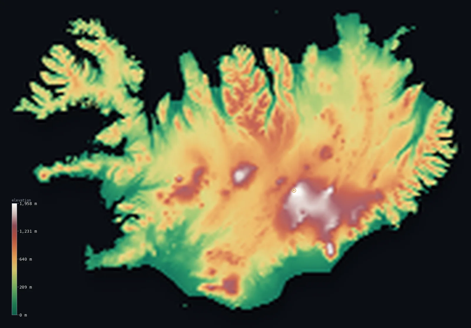
Iceland’s highest point is Hvannadalshnúkur at 6,923 ft (2,110 m); its lowest is Atlantic Ocean coast at 0 ft (0 m); the mean elevation is 1,657 ft (505 m).
Iceland is a plateau with a rim of habitation. Its interior — the Highlands — is a raised volcanic desert of lava, ash, and ice caps where almost nobody lives, and it lifts half the island above 1,555 ft (474 m). Yet the country tops out at only 6,923 ft (2,110 m), at Hvannadalshnúkur on the edge of Europe's largest glacier: a high floor beneath a low ceiling.
- Highest point📚
- 6,923 ft2,110 m
- Iceland's highest point is Hvannadalshnúkur at 6,923 ft (2,110 m), a peak on the rim of the Öræfajökull volcano — itself buried beneath an outlet of Vatnajökull, the largest ice cap in Europe. The summit is glacier ice standing over a volcanic crater.
- Lowest point📚
- 0 ft0 m
- Iceland's lowest point is sea level, along a coastline of fjords in the north and west and black sand plains in the south — the narrow ring of low ground where virtually the entire population lives.
- Mean elevation⚙
- 1,657 ft505 m
- Iceland's mean elevation computed from the GLO-30 model is 1,657 ft (505 m) — high for a North Atlantic island, and entirely the work of the interior Highlands, a raised volcanic tableland that fills the middle of the country.
- Median elevation⚙
- 1,555 ft474 m
- Half of Iceland lies above 1,555 ft (474 m), close to the mean — the signature of a plateau rather than a mountain range: the interior sits uniformly high rather than climbing to peaks.
- Elevation range📚
- 6,923 ft2,110 m
- From the sea to Hvannadalshnúkur, Iceland spans only about 6,900 ft — a modest ceiling for a country so volcanically active, and the reason its terrain reads as a broad raised table rather than an alpine landscape.
- Above 1,000 m (3,281 ft)⚙
- 10%
- About 10% of Iceland rises above 1,000 m (3,281 ft) — the highest parts of the Highlands and the ice caps — and above 1,500 m the land all but disappears: the country effectively ends before the heights most mountain nations begin at.
- Official area📚
- 39,769 mi²103,000 km²
- Iceland covers about 39,769 sq mi (103,000 sq km), a single volcanic island sitting astride the Mid-Atlantic Ridge where the North American and Eurasian plates pull apart — which is why it exists at all.
- Forest cover📚
- 2%
- Only about 2% of Iceland is forested — one of the least wooded countries on Earth. Birch woodland that covered much of the lowland at settlement was cleared within a few centuries, and the cold, windy, volcanic ground has kept the island near-treeless since.
Highest and lowest points
Iceland's highest point is Hvannadalshnúkur, 6,923 ft (2,110 m), a peak on the northwestern rim of the Öræfajökull volcano in the southeast. The summit is not bare rock but ice: it stands on an outlet of Vatnajökull, the largest glacier in Europe by volume, which buries the volcano beneath it. On this 30-metre elevation model the glaciated crest reads a little lower than the surveyed height; the figure above is the surveyed elevation.
source ↗Iceland's lowest point is sea level, and the coast is where the country actually lives. Almost the entire population rings the island on a narrow coastal strip — fjord-cut in the north and west, fringed in the south by broad black sandurs, plains of volcanic sand and gravel washed out by glacial floods. Inland from that ring, the Highlands are effectively uninhabited.
source ↗Iceland at a glance
Iceland's highest point, Hvannadalshnúkur (2,110 m), is a glacier-covered peak on the rim of the Öræfajökull volcano, beneath Vatnajökull - the largest ice cap in Europe.
source ↗Iceland sits astride the Mid-Atlantic Ridge, where the North American and Eurasian plates pull apart - the island is built entirely from volcanic activity along that rift.
source ↗About 11% of Iceland is covered by glaciers, including Vatnajökull, the largest ice cap in Europe by volume.
source ↗The interior Highlands are a volcanic desert of lava, ash, and ice where essentially nobody lives - almost the whole population rings the coast.
source ↗Only around 2% of Iceland is forested; the birch woods present at settlement were cleared within a few centuries and never recovered.
source ↗Iceland's south coast is fringed by sandurs - vast black plains of sand and gravel laid down by floods bursting out from beneath the glaciers.
source ↗
Elevation profile of Iceland
The largest share of land, 24%, falls in the 0–200 m band, with the land split almost evenly above and below 500 m (1,640 ft).
- below 500 m (1,640 ft)53%
- 500–1,000 m37%
- 1,000–2,000 m10%
- above 2,000 m (6,562 ft)<1%
Highest peaks of Iceland
| Peak | Elevation | Range | Note |
|---|---|---|---|
| Hvannadalshnúkur↗ | 6,923 ft2,110 m | Öræfajökull (Vatnajökull) | Iceland's highest point, on the crater rim of the Öræfajökull volcano; permanently ice-covered. |
| Bárðarbunga↗ | 6,591 ft2,009 m | Vatnajökull | A subglacial stratovolcano beneath the Vatnajökull ice cap; source of a major 2014–15 eruption. |
| Kverkfjöll↗ | 6,299 ft1,920 m | Vatnajökull | A volcanic massif on the northern rim of Vatnajökull with extensive geothermal ice caves. |
| Snæfell↗ | 6,014 ft1,833 m | Eastern Highlands | A free-standing extinct volcano east of Vatnajökull, the highest Icelandic mountain outside the main ice caps. |
| Kerling↗ | 5,046 ft1,538 m | Tröllaskagi | Highest peak of the Tröllaskagi peninsula — the highest ground in Iceland outside the central highlands. |
The shape of Iceland
The Central Highlands
The interior of Iceland is a raised volcanic plateau — lava fields, ash deserts, and bare gravel above 400 to 800 m, crossed by rift zones and active volcanic systems. Almost nobody lives here, and it is what lifts the whole island's average elevation.
The ice caps
Glaciers cover about 11% of Iceland, dominated by Vatnajökull in the southeast, the largest ice cap in Europe by volume, which buries several active volcanoes including Öræfajökull and carries the country's high point on its rim.
The coastal lowlands and fjords
The habitable ring: fjords cut deeply into the north and west, while the south and southwest hold broad lowlands and the sandur plains. Nearly the entire population lives on this narrow coastal margin.
The peninsulas and the rift
The Reykjanes peninsula in the southwest and the Westfjords in the northwest give the island its ragged outline; the Reykjanes rift, part of the Mid-Atlantic Ridge, comes ashore here and has been erupting in recent years.
How to read this map
Color shows elevation; the raised relief shows real terrain. On this map Iceland reads as a raised brown-and-white interior — the Highlands and the ice caps — ringed by a thin green coastal band and cut by fjords in the north and west.
The 3D relief is the actual GLO-30 elevation data, exaggerated vertically so the plateau's rise and the glacier domes both show; the ×N relief slider controls how much. Tap anywhere to read that point's exact elevation.
City elevations in Iceland
Icelandic towns are all coastal. Reykjavík, home to most of the country's population, sits at around 120 ft on the southwestern shore, and every other settlement rings the island — the interior Highlands have no towns at all.
| City | Population | Elevation |
|---|---|---|
| Reykjavíkcapitalthe capital, on the southwest coast - the world's northernmost capital of a sovereign state ↗ | 118,918 | 118 ft36 m |
| Akureyri | 19,219 | 10 ft3 m |
| Selfoss | 9,000 | 59 ft18 m |
| Vestmannaeyjar | 4,639 | 23 ft7 m |
| Norðurþing | 3,234 | 72 ft22 m |
| Grindavík | 2,856 | 23 ft7 m |
| Ísafjörður | 2,736 | 69 ft21 m |
| Sauðárkrókur | 2,614 | 7 ft2 m |
| Egilsstaðir | 2,572 | 141 ft43 m |
| Borgarnes | 1,875 | 36 ft11 m |
Elevation sampled at each city centre from the Copernicus GLO-30 model. Cities and population from GeoNames (CC-BY 4.0).
Iceland in comparison
Iceland's terrain rises 6,923 ft (2,110 m) from sea level to Hvannadalshnúkur — about 24% of the height of Mount Everest, the world's highest point at 29,032 ft (8,849 m).
- Norway's mean elevation is 1,831 ft — 174 ft higher; its high point, Galdhopiggen, reaches 8,100 ft (2,469 m), 1,178 ft above. Norway elevation map →
- Switzerland's mean elevation is 4,301 ft — 2,644 ft higher; its high point, Dufourspitze (Monte Rosa), reaches 15,203 ft (4,634 m), 8,281 ft above. Switzerland elevation map →
- New Zealand's mean elevation is 1,608 ft — 49 ft lower; its high point, Aoraki / Mount Cook, reaches 12,218 ft (3,724 m), 5,295 ft above. New Zealand elevation map →
Frequently asked questions
What is the highest point in Iceland?
- Hvannadalshnúkur, 6,923 ft (2,110 m), a glacier-covered peak on the rim of the Öræfajökull volcano beneath Vatnajökull.
What is the lowest point in Iceland?
- Sea level - the coastal ring where almost the entire population lives.
What is the average elevation of Iceland?
- Computed from the Copernicus GLO-30 model, the area-weighted mean is 1,657 ft (505 m) - high for an island, because the uninhabited interior Highlands form a raised volcanic plateau.
Why is Iceland volcanic?
- It sits directly on the Mid-Atlantic Ridge, where the North American and Eurasian plates pull apart - the island was built by, and is still being built by, volcanic activity along that rift.
How much of Iceland is covered by glaciers?
- About 11%, dominated by Vatnajökull in the southeast - the largest ice cap in Europe by volume.
Is this a topographic, relief, contour, or elevation map of Iceland?
- They describe the same thing - terrain height. This page renders the country's actual elevation surface in interactive 3D and reports the statistics computed from it.
About this map
The terrain is rendered from the Copernicus GLO-30 digital elevation model (ESA), masked to the ISL-ADM0 boundary from geoBoundaries (gbOpen). Elevation statistics are computed directly from the model; peak names and researched facts are sourced and cited. See the methodology for the full pipeline.
Our area-weighted mean, computed from the Copernicus GLO-30 model, is 1,657 ft (505 m); the figure commonly cited elsewhere is 1,640 ft (500 m) (Encyclopaedia Britannica). Iceland is essentially a volcanic plateau ringed by mountains, with a quarter of the country lying below about 200 m and most of the interior a high, uninhabited desert; the page reports the area-weighted mean computed from the Copernicus GLO-30 model.
Surveyed national figures: official area · forest cover · high point.
Rendered from Copernicus GLO-30 (ESA, 2021 release), boundaries from geoBoundaries. Generated 2026-06-19.