New Zealand Elevation Map — Topographic & 3D Terrain
Explore the terrain of New Zealand in interactive 3D, built from Copernicus GLO-30 satellite elevation data — two long islands split by a young, still-rising mountain spine. Drag to rotate, scroll to zoom, and tap any point to read its elevation.
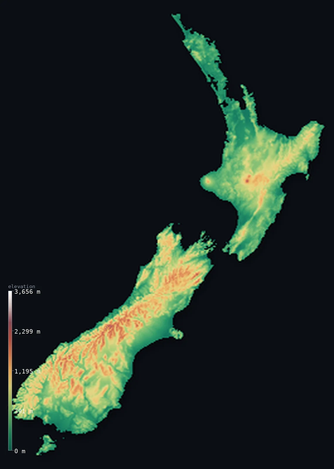
New Zealand’s highest point is Aoraki / Mount Cook at 12,218 ft (3,724 m); its lowest is Pacific Ocean coast at 0 ft (0 m); the mean elevation is 1,608 ft (490 m).
New Zealand is two islands with two different origins. The South Island is split lengthwise by the Southern Alps, thrown up along the collision of two tectonic plates and still rising — they carry Aoraki / Mount Cook at 12,218 ft (3,724 m) and dozens of glaciers. The North Island is volcanic instead, built around a central plateau of craters, lakes, and active cones. Most of the country stays low, though: 62% lies below 1,640 ft (500 m).
- Highest point📚
- 12,218 ft3,724 m
- New Zealand's highest point is Aoraki / Mount Cook at 12,218 ft (3,724 m), in the Southern Alps — a steep, heavily glaciated peak that actually lost about 10 metres of height in 1991, when a rock and ice avalanche took away part of its summit.
- Lowest point📚
- 0 ft0 m
- New Zealand's lowest point is sea level, and nowhere in the country is far from it — the two islands are long and narrow, so the sea is rarely more than 130 km away wherever you stand.
- Mean elevation⚙
- 1,608 ft490 m
- New Zealand's mean elevation computed from the GLO-30 model is 1,608 ft (490 m) — modest, because although the Southern Alps are steep and high, they form a narrow spine, and most of the country is hill country, plain, and coast.
- Median elevation⚙
- 1,168 ft356 m
- Half of New Zealand lies below 1,168 ft (356 m) — well under the mean, the mark of a country where a narrow band of very steep mountains is set against a much larger area of low hills and plains like Canterbury.
- Elevation range📚
- 12,218 ft3,724 m
- From the sea to Aoraki, New Zealand spans about 12,200 ft — and it crosses that range remarkably fast: on the South Island's west coast, the Alps rise from the shore to over 3,000 m within about 30 km.
- Above 1,000 m (3,281 ft)⚙
- 14%
- About 14% of New Zealand rises above 1,000 m (3,281 ft) — almost all of it the Southern Alps and the higher volcanic peaks of the North Island's central plateau.
- Official area📚
- 103,483 mi²268,021 km²
- New Zealand covers about 103,484 sq mi (268,021 sq km) across two main islands and hundreds of smaller ones — long, narrow, and so far from anywhere else that its nearest substantial neighbour is over 1,500 km away.
- Forest cover📚
- 38%
- About 38% of New Zealand is forested — temperate rainforest on the wet western slopes of the Southern Alps and through Fiordland, and regenerating bush across the North Island hill country.
Highest and lowest points
New Zealand's highest point is Aoraki / Mount Cook, 12,218 ft (3,724 m), in the Southern Alps of the South Island. Its height is not fixed: in December 1991 a huge rock and ice avalanche fell from the summit, and later surveys found the peak about 10 metres lower than before. The mountain sits on the Alpine Fault, where the Pacific and Australian plates grind past each other and are still pushing the range upward faster than erosion can wear it down. On this elevation model its glaciated crest reads slightly below the surveyed figure shown above.
source ↗New Zealand's lowest point is sea level, which in this country is never far off. Both main islands are long and narrow, so no point in the country lies more than about 130 km from the coast. The shoreline changes character completely along its length: the wild, rain-soaked west coast of the South Island; the drowned glacial valleys of Fiordland, where the sea runs deep inland between vertical walls; and the mild harbours of the north, where Auckland is built across an isthmus barely a few kilometres wide.
source ↗New Zealand at a glance
Aoraki / Mount Cook lost about 10 metres of height in 1991, when a rock and ice avalanche removed part of its summit - the mountain is now surveyed at 3,724 m.
source ↗The Southern Alps are still rising along the Alpine Fault, where the Pacific and Australian plates meet - uplift there is among the fastest anywhere, though erosion removes much of it.
source ↗New Zealand's two main islands have different origins: the South Island is built by mountain-building along a plate boundary, the North Island by volcanism.
source ↗The North Island's Central Plateau is a volcanic landscape of active cones and calderas, including Lake Taupo, which fills the crater of an enormous eruption.
source ↗Fiordland in the southwest is carved into deep fjords by ice-age glaciers, with some of the steepest coastal relief in the world.
source ↗No point in New Zealand is much more than about 130 km from the sea - both islands are long and narrow.
source ↗
Elevation profile of New Zealand
The largest share of land, 39%, falls in the 0–250 m band, and 62% of the territory lies below 500 m (1,640 ft).
- below 500 m (1,640 ft)62%
- 500–1,000 m24%
- 1,000–2,000 m14%
- above 2,000 m (6,562 ft)<1%
Highest peaks of New Zealand
| Peak | Elevation | Range | Note |
|---|---|---|---|
| Aoraki / Mount Cook↗ | 12,218 ft3,724 m | Southern Alps | Highest point of New Zealand; a triple-summited peak, sacred to Ngāi Tahu. |
| Mount Tasman / Horokoau↗ | 11,473 ft3,497 m | Southern Alps | New Zealand's second-highest mountain, just north of Aoraki on the Main Divide. |
| Mount Dampier / Rakiroa↗ | 11,286 ft3,440 m | Southern Alps | Third-highest peak, on the ridge running north from Aoraki. |
| Aoraki Mackenzie high peaks (Hicks / Sefton)↗ | 10,492 ft3,198 m | Southern Alps | Of New Zealand's roughly 20 peaks over 3,000 m, all but Mount Aspiring lie in the Aoraki / Mount Cook National Park. |
| Mount Aspiring / Tititea↗ | 9,951 ft3,033 m | Southern Alps | A striking horn peak — the only 3,000 m+ summit outside the Aoraki park, in Mount Aspiring National Park. |
| Mount Ruapehu↗ | 9,177 ft2,797 m | North Island Volcanic Plateau | Highest point of the North Island — an active andesite stratovolcano, the only North Island peak that keeps glaciers. |
The two islands
The Southern Alps
A continuous mountain spine runs almost the length of the South Island, thrown up along the Alpine Fault where two tectonic plates collide. It carries Aoraki / Mount Cook, all of New Zealand's 3,000-metre peaks, and hundreds of glaciers — and it is still rising.
The Canterbury Plains and the eastern lowlands
East of the Alps, rivers of gravel washed down from the mountains have built the Canterbury Plains, the largest area of flat land in the country. Dry in the mountains' rain shadow, they are the South Island's farming heartland.
The North Island Volcanic Plateau
The centre of the North Island is a volcanic upland of craters, lava plateaus, and active cones — Ruapehu, Ngauruhoe, Taranaki — along with Lake Taupo, which fills a vast caldera. It is a landscape built by eruption rather than collision.
The North Island hill country
Around the volcanic centre, the North Island is mostly rolling to steep hill country — soft, eroding rock cut by rivers, greener and gentler than the South Island's mountains, and holding most of the country's population.
Fiordland and the southwest
The southwestern corner is Fiordland: glacier-carved valleys drowned by the sea, with cliffs rising more than a kilometre straight from deep water — among the steepest and least accessible coastline anywhere.
How to read this map
Color shows elevation; the raised relief shows real terrain. On this map New Zealand reads as two long islands — the South Island split by a sharp white-and-brown alpine spine falling steeply west, the North Island softer with a raised volcanic centre.
The 3D relief is the actual GLO-30 elevation data, exaggerated vertically so the Alps' steepness and the volcanic plateau both stand out; the ×N relief slider controls how much. Tap anywhere to read that point's exact elevation.
City elevations in New Zealand
New Zealand's cities are coastal without exception. Auckland spreads across a narrow isthmus between two harbours, Wellington sits at the bottom of the North Island where the strait divides the country, and Christchurch lies on the flat Canterbury Plains — all within a few dozen feet of the sea.
| City | Population | Elevation |
|---|---|---|
| Aucklandon a narrow volcanic isthmus between two harbours, the country's largest city ↗ | 1,547,200 | 112 ft34 m |
| Christchurchon the flat Canterbury Plains east of the Southern Alps, near sea level ↗ | 419,200 | 30 ft9 m |
| Wellingtoncapitalthe capital, on a harbour at the southern tip of the North Island, at sea level ↗ | 381,900 | 66 ft20 m |
| Hamilton | 192,100 | 118 ft36 m |
| Dunedin | 132,800 | 62 ft19 m |
| Palmerston North | 90,500 | 112 ft34 m |
| New Plymouth | 90,100 | 184 ft56 m |
| Hastings | 88,300 | 39 ft12 m |
| Invercargill | 58,000 | 20 ft6 m |
| Nelson | 54,400 | 16 ft5 m |
Elevation sampled at each city centre from the Copernicus GLO-30 model. Cities and population from GeoNames (CC-BY 4.0).
New Zealand in comparison
New Zealand's terrain rises 12,218 ft (3,724 m) from sea level to Aoraki / Mount Cook — about 42% of the height of Mount Everest, the world's highest point at 29,032 ft (8,849 m).
- Norway's mean elevation is 1,831 ft — 223 ft higher; its high point, Galdhopiggen, reaches 8,100 ft (2,469 m), 4,117 ft below. Norway elevation map →
- Switzerland's mean elevation is 4,301 ft — 2,694 ft higher; its high point, Dufourspitze (Monte Rosa), reaches 15,203 ft (4,634 m), 2,986 ft above. Switzerland elevation map →
- Chile's mean elevation is 4,341 ft — 2,733 ft higher; its high point, Ojos del Salado, reaches 22,615 ft (6,893 m), 10,397 ft above. Chile elevation map →
Frequently asked questions
What is the highest point in New Zealand?
- Aoraki / Mount Cook, 12,218 ft (3,724 m), in the Southern Alps - about 10 m lower than before a 1991 avalanche removed part of its summit.
What is the lowest point in New Zealand?
- Sea level - and nowhere in the country is much more than about 130 km from the coast.
What is the average elevation of New Zealand?
- Computed from the Copernicus GLO-30 model, the area-weighted mean is 1,608 ft (490 m) - modest, since the Southern Alps form a narrow spine and most of the country is hill and plain.
Why are the two islands so different?
- The South Island's mountains were thrown up by two tectonic plates colliding along the Alpine Fault, while the North Island was built largely by volcanism - a plateau of craters, calderas, and active cones.
Are the Southern Alps still growing?
- Yes - uplift along the Alpine Fault is among the fastest in the world, though erosion strips away much of the gain.
Is this a topographic, relief, contour, or elevation map of New Zealand?
- They describe the same thing - terrain height. This page renders the country's actual elevation surface in interactive 3D and reports the statistics computed from it.
About this map
The terrain is rendered from the Copernicus GLO-30 digital elevation model (ESA), masked to the NZL-ADM0 boundary from geoBoundaries (gbOpen). Elevation statistics are computed directly from the model; peak names and researched facts are sourced and cited. See the methodology for the full pipeline.
Our area-weighted mean, computed from the Copernicus GLO-30 model, is 1,608 ft (490 m); the figure commonly cited elsewhere is 1,273 ft (388 m) (CIA World Factbook). New Zealand splits into a rolling, volcanic North Island and a steeply mountainous South Island where the Southern Alps run almost the whole length; the page reports the area-weighted figure computed from the Copernicus GLO-30 model.
Surveyed national figures: official area · forest cover · high point.
Rendered from Copernicus GLO-30 (ESA, 2021 release), boundaries from geoBoundaries. Generated 2026-06-21.