Finland Elevation Map — Topographic & 3D Terrain
Explore the terrain of Finland in interactive 3D, built from Copernicus GLO-30 satellite elevation data — a low, lake-scattered forest plain with barely a mountain in it. Drag to rotate, scroll to zoom, and tap any point to read its elevation.
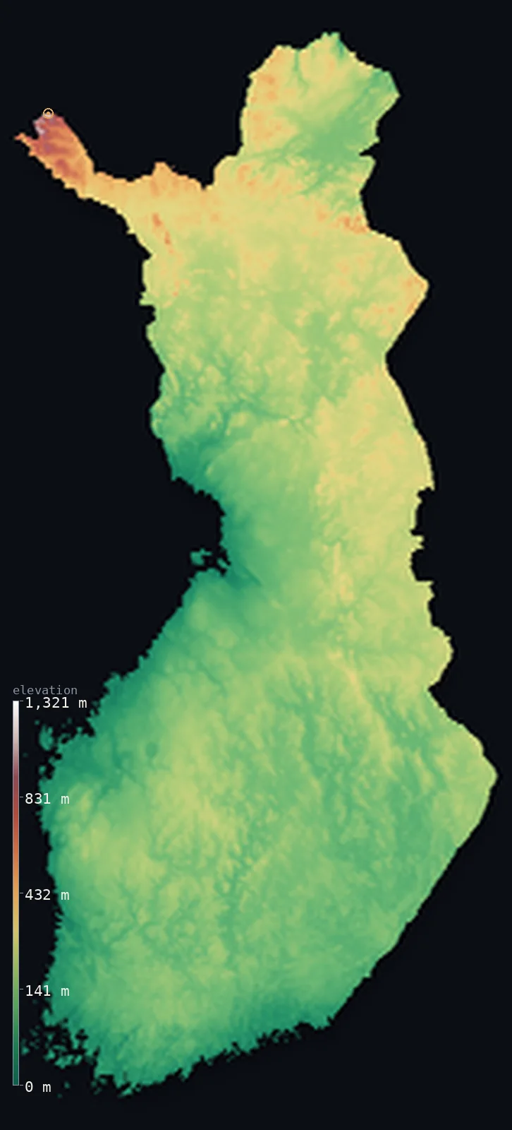
Finland’s highest point is Halti (Halditsohkka) at 4,344 ft (1,324 m); its lowest is Baltic Sea at 0 ft (0 m); the mean elevation is 515 ft (157 m).
Finland barely rises. Its mean elevation is just 515 ft (157 m), a huge share of the country sits in a single band between 100 and 200 m, and the land is so uniformly low that its 188,000 lakes are less interruptions than the landscape itself. Even its highest point is borrowed: Halti reaches 4,344 ft (1,324 m), but that figure is only the Finnish shoulder of the mountain — the actual summit stands about a kilometre away, inside Norway.
- Highest point📚
- 4,344 ft1,324 m
- Finland's highest point is Halti at 4,344 ft (1,324 m), in the far northwestern arm that reaches into the Scandinavian mountains — and it is not a summit at all but a shoulder: the mountain's true top, about 40 m higher, lies roughly a kilometre north, across the border in Norway.
- Lowest point📚
- 0 ft0 m
- Finland's lowest point is the Baltic shore at sea level — though the coast is a moving target, since the land here is still rebounding upward after the weight of the ice age lifted, slowly pushing new ground out of the sea.
- Mean elevation⚙
- 515 ft157 m
- Finland's mean elevation computed from the GLO-30 model is 515 ft (157 m) — one of the lowest national averages in Europe, and an honest summary of a country that is essentially one vast, gently undulating forest plain.
- Median elevation⚙
- 446 ft136 m
- Half of Finland lies below 446 ft (136 m), close to the mean — because the country has almost no variation to average out. A remarkable share of all Finnish land sits in the single narrow band between 100 and 200 m.
- Elevation range📚
- 4,344 ft1,324 m
- From the Baltic shore to Halti, Finland spans only about 4,340 ft — one of the narrowest elevation ranges of any large European country, and nearly all of that height is confined to the far northwestern arm.
- Above 1,000 m (3,281 ft)⚙
- <1%
- Only about 27% of Finland rises above 656 ft (200 m) at all, and almost none of the country reaches 1,000 m — the small area that does lies entirely in the northwestern arm where Finland touches the Scandinavian mountains.
- Official area📚
- 130,558 mi²338,145 km²
- Finland covers about 131,000 sq mi (338,145 sq km) — most of it forest and water, stretching from the Gulf of Finland north across the Arctic Circle into Lapland.
- Forest cover📚
- 73.7%
- About 74% of Finland is forest — the highest share in Europe. Spruce, pine, and birch cover almost the entire country, thinning only in the far north where Lapland's fells rise above the tree line.
Highest and lowest points
Finland's highest point is Halti, 4,344 ft (1,324 m), in the narrow northwestern arm where the country reaches into the Scandinavian mountains — and it is an unusual high point, because it is not a summit. The actual peak of the mountain, about 40 m taller, stands roughly a kilometre north across the border in Norway; Finland's highest ground is the shoulder that stops at the frontier. Norway has, at various points, discussed gifting the summit to Finland as a birthday present, though it has never happened.
source ↗Finland's lowest point is the Baltic coast at sea level — but the coastline is not fixed. The ice sheet that covered Finland pressed the crust down, and since it melted the land has been rising again, several millimetres a year in the west. New land is still emerging from the Gulf of Bothnia: islands join the mainland, harbours silt up, and the country very slowly grows.
source ↗Finland at a glance
Finland's highest point, Halti at 1,324 m, is not a summit but a shoulder - the mountain's true peak stands about a kilometre away inside Norway.
source ↗About 74% of Finland is forest, the highest share of any country in Europe.
source ↗Finland has roughly 188,000 lakes, so many that water and forest together make up the great majority of the country's surface.
source ↗Finland's mean elevation is only about 157 m - one of the lowest in Europe, with a large share of the country sitting in the narrow band between 100 and 200 m.
source ↗Finland is still rising out of the sea: the land rebounds several millimetres a year after the ice sheet's weight was removed, slowly adding new coastline in the Gulf of Bothnia.
source ↗The country's only genuinely mountainous ground is the northwestern arm in Lapland, where Finland touches the Scandinavian range.
source ↗The highest mountain lying entirely within Finland is not Halti but the nearby Ridnitsohkka, at 1,316 m.
source ↗
Elevation profile of Finland
The largest share of land, 44%, falls in the 100–200 m band, and 99% of the territory lies below 500 m (1,640 ft).
- below 500 m (1,640 ft)99%
- 500–1,000 m1%
- 1,000–2,000 m<1%
Highest peaks of Finland
| Peak | Elevation | Range | Note |
|---|---|---|---|
| Halti (Halditsohkka)↗ | 4,344 ft1,324 m | Scandinavian Mountains (northwest arm) | Highest point of Finland, a border-slope spur of Raisduottarhaldi whose peak is in Norway. |
| Ridnitsohkka↗ | 4,318 ft1,316 m | Scandinavian Mountains (northwest arm) | The highest summit lying entirely within Finland, a few kilometres from Halti. |
| Saana↗ | 3,376 ft1,029 m | Scandinavian Mountains (northwest arm) | An iconic flat-topped fell above Kilpisjarvi, a landmark of the northwestern arm. |
Coast, lakeland, and Lapland
The coastal lowlands and archipelago
Finland's southern and western edges are its lowest and most settled ground — flat coastal plain giving way to a fringe of tens of thousands of islands and skerries in the Baltic. This is where Helsinki, Turku, and most Finns are, and where the land is still rising out of the sea.
The lake and forest interior
The great body of the country is a low, gently rolling plateau of forest and water — the Finnish Lakeland, where roughly 188,000 lakes are woven through spruce and pine on ground scraped smooth by ice. It rarely rises far above 200 m, and it is what makes Finland's terrain statistics so uniform.
Lapland and the northwestern arm
The north is Lapland: higher, barer, and treeless in places, rising to rounded fells above the Arctic Circle. In the narrow northwestern arm, where Finland reaches toward Norway, the land finally becomes mountain and carries Halti, the country's high point.
How to read this map
Color shows elevation; the raised relief shows real terrain. On this map Finland reads almost entirely in low greens, mottled with the dark shapes of its lakes, with faint browns appearing only in the northwestern arm.
The 3D relief is the actual GLO-30 elevation data, exaggerated vertically far more than usual so that a country this uniformly low shows any shape at all; the ×N relief slider controls how much. Tap anywhere to read that point's exact elevation.
City elevations in Finland
Finnish cities are coastal and southern almost without exception - Helsinki on the Gulf of Finland, Turku on the southwest shore, both barely above sea level. In a country this flat, the difference between the lowest city and the highest is a matter of a few dozen metres.
| City | Population | Elevation |
|---|---|---|
| Helsinkicapitalthe capital, on a peninsula and islands of the Gulf of Finland, near sea level ↗ | 658,864 | 66 ft20 m |
| Tampere | 260,646 | 351 ft107 m |
| Oulu | 216,066 | 36 ft11 m |
| Turku | 206,655 | 46 ft14 m |
| Jyväskylä | 148,744 | 381 ft116 m |
| Kuopio | 125,462 | 341 ft104 m |
| Lahti | 121,622 | 361 ft110 m |
| Pori | 83,157 | 36 ft11 m |
| Joensuu | 78,398 | 276 ft84 m |
| Lappeenranta | 72,909 | 335 ft102 m |
Elevation sampled at each city centre from the Copernicus GLO-30 model. Cities and population from GeoNames (CC-BY 4.0).
Finland in comparison
Finland's terrain rises 4,344 ft (1,324 m) from sea level to Halti (Halditsohkka) — about 15% of the height of Mount Everest, the world's highest point at 29,032 ft (8,849 m).
- Sweden's mean elevation is 1,050 ft — 535 ft higher; its high point, Kebnekaise (North Peak), reaches 6,880 ft (2,097 m), 2,536 ft above. Sweden elevation map →
- Estonia's mean elevation is 187 ft — 328 ft lower; its high point, Suur Munamagi, reaches 1,043 ft (318 m), 3,301 ft below. Estonia elevation map →
- Norway's mean elevation is 1,831 ft — 1,316 ft higher; its high point, Galdhopiggen, reaches 8,100 ft (2,469 m), 3,757 ft above. Norway elevation map →
Frequently asked questions
What is the highest point in Finland?
- Halti, 4,344 ft (1,324 m), in the northwestern arm - though it is a shoulder rather than a summit: the mountain's true peak lies about a kilometre away in Norway.
What is the lowest point in Finland?
- The Baltic coast at sea level - and the coastline is still changing, as the land continues to rebound upward after the ice age.
What is the average elevation of Finland?
- Computed from the Copernicus GLO-30 model, the area-weighted mean is 515 ft (157 m) - among the lowest in Europe, since almost the whole country is a low forest and lake plain.
How many lakes does Finland have?
- About 188,000 - so many that lakes and forest together cover most of the country's surface.
Is Finland mountainous?
- Barely - only about 27% of the country rises above 200 m, and its only genuinely mountainous ground is the narrow northwestern arm in Lapland.
Is this a topographic, relief, contour, or elevation map of Finland?
- They describe the same thing - terrain height. This page renders the country's actual elevation surface in interactive 3D and reports the statistics computed from it.
About this map
The terrain is rendered from the Copernicus GLO-30 digital elevation model (ESA), masked to the FIN-ADM0 boundary from geoBoundaries (gbOpen). Elevation statistics are computed directly from the model; peak names and researched facts are sourced and cited. See the methodology for the full pipeline.
Our area-weighted mean, computed from the Copernicus GLO-30 model, is 515 ft (157 m); the figure commonly cited elsewhere is 538 ft (164 m) (CIA World Factbook). Finland is a low, flat country of glacial lowland, lakes and forest, with real relief only in the far northwestern 'arm', so the mean elevation is low; the page reports the area-weighted figure computed from the Copernicus GLO-30 model.
Surveyed national figures: official area · forest cover · high point.
Rendered from Copernicus GLO-30 (ESA, 2021 release), boundaries from geoBoundaries. Generated 2026-06-23.
Bordering countries · 3
Finland shares a land border with these countries — open any one to compare its terrain and highest point.