Sweden Elevation Map — Topographic & 3D Terrain
Explore the terrain of Sweden in interactive 3D, built from Copernicus GLO-30 satellite elevation data — a long forested lowland tilting up to a mountain spine in the far northwest. Drag to rotate, scroll to zoom, and tap any point to read its elevation.
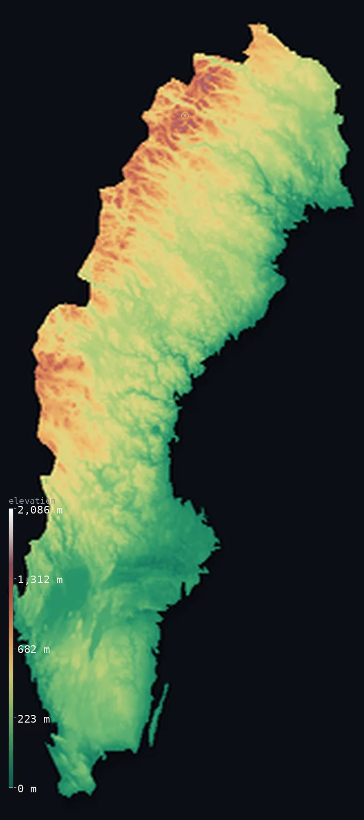
Sweden’s highest point is Kebnekaise (North Peak) at 6,880 ft (2,097 m); its lowest is Reclaimed bay of Lake Hammarsjon, near Kristianstad at −7 ft (−2 m); the mean elevation is 1,050 ft (320 m).
Sweden's highest point changed in the last decade — and not because anyone remeasured it. For most of the 20th century the summit of Kebnekaise was its glacier-capped south peak; as that ice melted away it lost about 24 metres, and by 2019 the bare rock of the north peak, 6,880 ft (2,097 m), had taken the title. That is the sharp end of a country that is otherwise low and forested: 69% of Sweden is woodland, and only about 2% of it rises above 3,281 ft (1,000 m).
- Highest point📚
- 6,880 ft2,097 m
- Sweden's highest point is the north peak of Kebnekaise at 6,880 ft (2,097 m) — the bare rock summit that inherited the title when the glacier on the neighbouring south peak, long the higher of the two, melted below it.
- Lowest point📚
- −7 ft−2 m
- Sweden's lowest point is a reclaimed bay near Kristianstad in the far south, about 7 ft (2 m) below sea level — drained farmland in a country that otherwise sits comfortably above the Baltic.
- Mean elevation⚙
- 1,050 ft320 m
- Sweden's mean elevation computed from the GLO-30 model is 1,050 ft (320 m) — low, and a fair description of the country: a long forested lowland that tilts gradually upward toward the Norwegian border and only becomes mountainous at its northwestern edge.
- Median elevation⚙
- 886 ft270 m
- Half of Sweden lies below 886 ft (270 m), close to the mean — the signature of a country with a steady tilt rather than dramatic extremes: the land rises gently across hundreds of kilometres instead of jumping.
- Elevation range📚
- 6,886 ft2,099 m
- From the reclaimed lowland near Kristianstad to the north peak of Kebnekaise, Sweden spans about 6,900 ft — a modest range for a country stretching 1,600 km from the Baltic south to well beyond the Arctic Circle.
- Above 1,000 m (3,281 ft)⚙
- 2%
- Only about 2% of Sweden rises above 1,000 m (3,281 ft) — the Scandinavian mountains along the Norwegian border in the far northwest, and essentially nowhere else. About a fifth of the country clears 500 m.
- Official area📚
- 173,860 mi²450,295 km²
- Sweden covers about 174,000 sq mi (450,295 sq km) — long enough that its southern farmland and its Arctic mountains sit in different worlds, with a thousand kilometres of forest and lake between them.
- Forest cover📚
- 68.9%
- About 69% of Sweden is forest — one of the most heavily wooded countries in Europe. The boreal taiga covers almost the entire north and centre, thinning only in the far south, where the farmland and most of the population are.
Highest and lowest points
Sweden's highest point is the north peak of Kebnekaise, 6,880 ft (2,097 m), in Lapland well inside the Arctic Circle — and the story of how it got the title is unusual. The mountain has two summits, and for a century the south peak was higher because it carried a glacier on top. That ice has been melting: the south peak has lost roughly 24 metres of height, and in 2019 it dropped below the bare rock of the north peak, which has been the country's highest point since. It is one of the few national summits on Earth to change identity within living memory.
source ↗Sweden's lowest point is a drained bay near Kristianstad in Skåne, the flat southern tip of the country, lying about 7 ft (2 m) below sea level. It is reclaimed land — the old bay was pumped dry for farming — and it is one of the few places in Sweden below the Baltic. The contrast with the rest of the country is total: this small patch of southern polder sits 2,000 m below the Arctic summit at the other end of the map.
source ↗Sweden at a glance
Sweden's highest point changed peaks in 2019 - the glacier-capped south summit of Kebnekaise melted by about 24 metres and fell below the bare rock north peak, which is now the country's high point at 2,097 m.
source ↗About 69% of Sweden is forest, one of the highest shares in Europe - boreal taiga covers almost the entire north and centre of the country.
source ↗Only around 2% of Sweden rises above 1,000 m, and all of it lies along the Scandinavian mountains at the Norwegian border.
source ↗Sweden stretches about 1,600 km from the Baltic in the south to far beyond the Arctic Circle, where the sun does not set in midsummer.
source ↗Sweden's lowest point, a reclaimed bay near Kristianstad, lies about 2 m below sea level - drained farmland in the flat far south.
source ↗Much of Sweden's landscape was scraped bare by ice-age glaciers, leaving thin soils, exposed bedrock, and tens of thousands of lakes across the interior.
source ↗Because the South Peak is snow and ice, its height changes with the seasons - higher in winter, lower after the summer melt.
source ↗
Elevation profile of Sweden
The largest share of land, 39%, falls in the 0–200 m band, and 80% of the territory lies below 500 m (1,640 ft).
- below 500 m (1,640 ft)80%
- 500–1,000 m18%
- 1,000–2,000 m2%
Highest peaks of Sweden
| Peak | Elevation | Range | Note |
|---|---|---|---|
| Kebnekaise (North Peak)↗ | 6,880 ft2,097 m | Scandinavian Mountains | Highest point of Sweden, an ice-free rock summit of fixed height (about 2,096.8 m). |
| Sarektjakka↗ | 6,854 ft2,089 m | Scandinavian Mountains (Sarek) | The high point of Sarek National Park - now essentially level with Kebnekaise's shrinking South Peak. |
| Kebnekaise (South Peak / Sydtoppen)↗ | 6,850 ft2,088 m | Scandinavian Mountains | The glaciated former high point of Sweden; its summit glacier has melted about 24 m in 50 years and now stands below the North Peak. |
| Helagsfjallet↗ | 5,896 ft1,797 m | Scandinavian Mountains (southern) | The highest mountain in Sweden south of the far-northern Lapland ranges. |
A lowland tilting to the mountains
Götaland and the southern lowlands
The far south is Sweden's flattest and most fertile ground — the plains of Skåne and the lowlands around the great lakes, where the country's farmland and much of its population lie. It is also where Sweden dips below sea level, in the reclaimed bay near Kristianstad.
The forested interior
Across the middle and north spreads the Norrland terrain: a vast, gently rising plateau of boreal forest, bog, and lake, cut by long rivers running southeast to the Baltic. Ice-scraped and thinly settled, it is the great bulk of the country — low, but never quite flat.
The Scandinavian mountains (the northwest)
Along the Norwegian border the land finally becomes mountain — the Scandinavian range, holding Kebnekaise and Sweden's only ground above 2,000 m, with the country's remaining glaciers. It is a narrow strip: nearly all of Sweden's high terrain is packed against this one edge.
How to read this map
Color shows elevation; the raised relief shows real terrain. On this map Sweden reads as a long green-and-brown lowland tilting slowly upward to the northwest, where a narrow band of white marks the mountains along the Norwegian border.
The 3D relief is the actual GLO-30 elevation data, exaggerated vertically so the gentle interior tilt still shows shape; the ×N relief slider controls how much. Tap anywhere to read that point's exact elevation.
City elevations in Sweden
Swedish cities sit low and mostly southern - Stockholm on its Baltic archipelago barely above sea level, Gothenburg and Malmö on the coasts. The population thins as the land rises north, so the country's high ground has almost no towns on it at all.
| City | Population | Elevation |
|---|---|---|
| Stockholmcapitalthe capital, spread across islands where Lake Mälaren meets the Baltic, at about 12 m ↗ | 1,515,017 | 39 ft12 m |
| Gothenburg | 608,462 | 39 ft12 m |
| Malmö | 362,133 | 43 ft13 m |
| Linköping | 166,673 | 190 ft58 m |
| Umeå | 130,224 | 49 ft15 m |
| Jönköping | 112,766 | 328 ft100 m |
| Luleå | 77,832 | 43 ft13 m |
| Gävle | 74,884 | 46 ft14 m |
| Växjö | 71,282 | 554 ft169 m |
| Halmstad | 70,480 | 30 ft9 m |
Elevation sampled at each city centre from the Copernicus GLO-30 model. Cities and population from GeoNames (CC-BY 4.0).
Sweden in comparison
Sweden's terrain rises 6,886 ft (2,099 m) from Reclaimed bay of Lake Hammarsjon, near Kristianstad, 7 ft (2 m) below sea level to Kebnekaise (North Peak) — about 24% of the height of Mount Everest, the world's highest point at 29,032 ft (8,849 m).
- Norway's mean elevation is 1,831 ft — 781 ft higher; its high point, Galdhopiggen, reaches 8,100 ft (2,469 m), 1,220 ft above. Norway elevation map →
- Finland's mean elevation is 515 ft — 535 ft lower; its high point, Halti (Halditsohkka), reaches 4,344 ft (1,324 m), 2,536 ft below. Finland elevation map →
- Denmark's mean elevation is 102 ft — 948 ft lower; its high point, Møllehøj, reaches 561 ft (171 m), 6,319 ft below. Denmark elevation map →
Frequently asked questions
What is the highest point in Sweden?
- The north peak of Kebnekaise, 6,880 ft (2,097 m), in Arctic Lapland - it became the country's high point in 2019 when the glacier on the neighbouring south peak melted below it.
What is the lowest point in Sweden?
- A reclaimed bay near Kristianstad in the far south, about 7 ft (2 m) below sea level.
What is the average elevation of Sweden?
- Computed from the Copernicus GLO-30 model, the area-weighted mean is 1,050 ft (320 m) - low, since most of the country is forested lowland and only the northwestern edge is mountainous.
Why did Sweden's highest point change?
- Kebnekaise has two summits. The south peak was higher because it carried a glacier, but that ice has lost about 24 metres to melting, and in 2019 the bare rock north peak became the taller of the two.
How much of Sweden is forest?
- About 69%, one of the highest shares in Europe - boreal taiga covering nearly the whole of the north and centre.
Is this a topographic, relief, contour, or elevation map of Sweden?
- They describe the same thing - terrain height. This page renders the country's actual elevation surface in interactive 3D and reports the statistics computed from it.
About this map
The terrain is rendered from the Copernicus GLO-30 digital elevation model (ESA), masked to the SWE-ADM0 boundary from geoBoundaries (gbOpen). Elevation statistics are computed directly from the model; peak names and researched facts are sourced and cited. See the methodology for the full pipeline.
This map renders 442,956 km² across 8 landmasses of Sweden. 2 smaller outlying parts — 3,072 km² in total — lie beyond the area shown here. Area statistics above count the full territory.
Our area-weighted mean, computed from the Copernicus GLO-30 model, is 1,050 ft (320 m); the figure commonly cited elsewhere is 1,050 ft (320 m) (CIA World Factbook). Sweden is mostly low to moderate ground - forested plains and hills sloping southeast from the Scandinavian Mountains toward the Baltic - rising to alpine heights only in the far northwest along the Norway border, so its mean elevation is moderate; the page reports the area-weighted figure computed from the Copernicus GLO-30 model.
Surveyed national figures: official area · forest cover · high point.
Rendered from Copernicus GLO-30 (ESA, 2021 release), boundaries from geoBoundaries. Generated 2026-07-18.
Bordering countries · 2
Sweden shares a land border with these countries — open any one to compare its terrain and highest point.