Denmark Elevation Map — Topographic & 3D Terrain
Explore the terrain of Denmark in interactive 3D, built from Copernicus GLO-30 satellite elevation data — one of the flattest countries on Earth, a lowland of moraine and reclaimed sea. Drag to rotate, scroll to zoom, and tap any point to read its elevation.
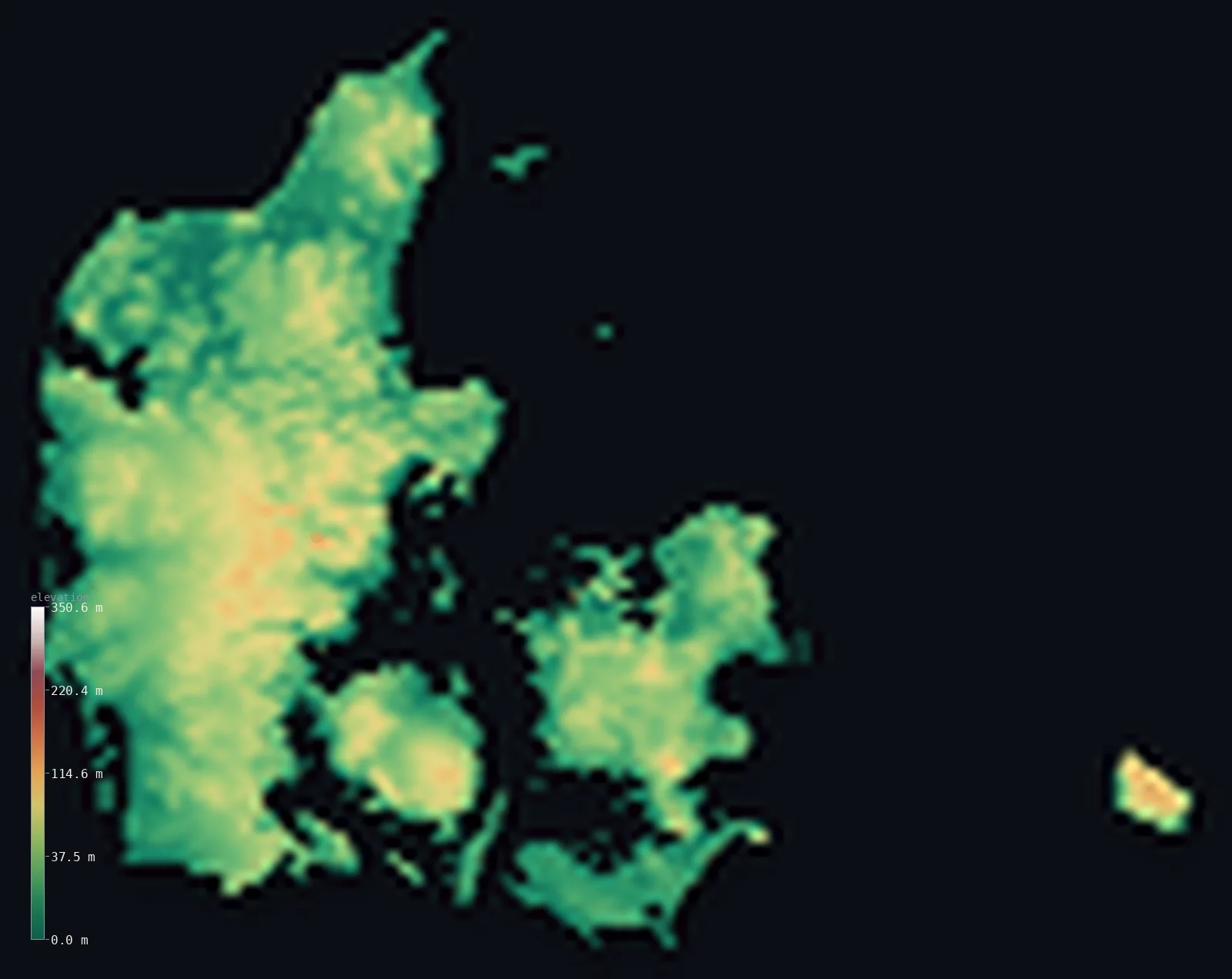
Denmark’s highest point is Møllehøj at 561 ft (171 m); its lowest is Lammefjord at −23 ft (−7 m); the mean elevation is 102 ft (31.2 m).
Denmark has almost no relief at all. The entire country lies below 656 ft (200 m) — every last hill of it — and its highest point, Møllehøj, reaches just 561 ft (171 m), a rise so slight that the title of 'highest in Denmark' has passed between three neighbouring hummocks, and Møllehøj holds it today by just 9 cm. This is a landscape built by ice and sea: low moraine left by retreating glaciers, and polders reclaimed from the water that dip below sea level at Lammefjord.
- Highest point📚
- 561 ft171 m
- Denmark's highest point is Møllehøj at 561 ft (171 m) — a gentle rise in the moraine hills of eastern Jutland, so close in height to its neighbours Yding Skovhøj and Ejer Bavnehøj that which one counts as the country's summit has changed with successive surveys, decided by margins of centimetres — Møllehøj tops Yding Skovhøj by just 9 cm and Ejer Bavnehøj by 51 cm.
- Lowest point📚
- −23 ft−7 m
- Denmark's lowest point is Lammefjord at about 23 ft (7 m) below sea level — a fjord that was pumped dry in the 19th century and turned to farmland, one of several reclaimed areas where Denmark sits beneath the sea it was taken from.
- Mean elevation⚙
- 102 ft31.2 m
- Denmark's mean elevation computed from the GLO-30 model is just 102 ft (31 m) — among the lowest of any country on Earth, and a faithful measure of a nation that is essentially one continuous low plain of field, moraine, and shallow coast.
- Median elevation⚙
- 91 ft27.6 m
- Half of Denmark lies below 91 ft (28 m) — close to the mean, because the country is so uniformly low: there is no high ground anywhere to pull the average up, only gentle undulation between the fields and the sea.
- Elevation range📚
- 584 ft178 m
- From Lammefjord below sea level to the top of Møllehøj, Denmark spans only about 580 ft — one of the smallest elevation ranges of any country in the world, so slight that the whole nation would fit comfortably below the tree line of an Alpine valley.
- Above 50 m (164 ft)⚙
- 21%
- Only about 21% of Denmark rises above 164 ft (50 m) — the low moraine ridges of eastern Jutland; the rest of the country lies lower still. Not one point in the whole of Denmark reaches even 656 ft (200 m): its terrain is measured in tens of metres, not hundreds, and its 'hills' are the ridges left where the last ice sheet halted.
- Official area📚
- 16,573 mi²42,924 km²
- Denmark covers about 16,600 sq mi (42,924 sq km) across the Jutland peninsula and an archipelago of more than 400 islands, of which Zealand — holding Copenhagen — and Funen are the largest.
- Forest cover📚
- 15.7%
- About 15.7% of Denmark is forested — a modest share in a country given over largely to farmland, one of the most intensively cultivated landscapes in Europe, with woodland surviving in scattered managed stands.
Highest and lowest points
Denmark's highest point is Møllehøj, 561 ft (171 m), in the moraine country of eastern Jutland — and it is the current answer to a question that has changed more than once. Three low hills here stand within a metre of one another: Møllehøj, Yding Skovhøj, and Ejer Bavnehøj. Yding Skovhøj was long listed highest — its mound-topped total reaching 172.54 m — until it was realised that Bronze Age mound on the summit did not count; on natural ground, Møllehøj now holds the title by just 9 cm over Yding Skovhøj and 51 cm over Ejer Bavnehøj. It is the kind of contest possible only in a country this flat.
source ↗Denmark's lowest point is the bottom of the drained Lammefjord on Zealand, about 23 ft (7 m) below sea level. It was a shallow arm of the sea until the 1870s, when it was diked off and pumped dry to create farmland — an echo, on a smaller scale, of the great reclamations across the North Sea in the Netherlands. Several such polders dot the Danish map, low rectangles of field lying beneath the level of the water held back beyond their dikes.
source ↗Denmark at a glance
No point in Denmark reaches even 200 m - the highest, Møllehøj, is just 171 m, the lowest national high point in the European Union.
source ↗Denmark's highest point has changed between three neighbouring hills - Møllehøj, Yding Skovhøj, and Ejer Bavnehøj - as surveys were refined: Møllehøj beats Yding Skovhøj by just 9 cm and Ejer Bavnehøj by 51 cm.
source ↗Yding Skovhøj would be the highest point at 172.54 m if the Bronze Age burial mound on its summit counted - but man-made mounds do not, so the natural high point is Møllehøj.
source ↗Denmark's lowest point, the drained Lammefjord, lies about 7 m below sea level - a fjord pumped dry in the 19th century and turned to farmland.
source ↗Denmark is made up of the Jutland peninsula and more than 400 islands, the largest being Zealand, home to Copenhagen.
source ↗The Danish landscape was shaped by ice-age glaciers, whose moraines left the country's only hills and whose meltwater laid down its sandy western plains.
source ↗
Elevation profile of Denmark
The largest share of land, 21%, falls in the 0–10 m band, and 100% of the territory lies below 500 m (1,640 ft).
- below sea level1%
- 0–10 m (0–33 ft)21%
- 10–50 m (33–164 ft)58%
- above 50 m (164 ft)21%
Highest peaks of Denmark
| Peak | Elevation | Range | Note |
|---|---|---|---|
| Møllehøj↗ | 561 ft171 m | Ejerbjerge (central Jutland) | Highest natural point of Denmark proper (170.86 m), marked by an old millstone. |
| Yding Skovhøj↗ | 561 ft171 m | central Jutland (Horsens) | 170.77 m of natural ground — 9 cm short of Møllehøj — but 172.54 m if its Bronze Age burial mound is counted. |
| Ejer Bavnehøj↗ | 558 ft170 m | Ejerbjerge (central Jutland) | Denmark's third-highest natural point (170.35 m); long thought the highest, it carries a 1924 memorial tower. |
| Himmelbjerget↗ | 482 ft147 m | central Jutland (Lakelands) | The 'Sky Mountain' — only 147 m, but long believed Denmark's highest and still one of its best-known hills. |
The peninsula, the islands, and the reclaimed coast
The Jutland peninsula
The Danish mainland, reaching north from the German border, split by a low north-south moraine ridge. Eastern Jutland is gently rolling farmland and holds the country's highest hills; the west is flatter, sandier outwash plain and heath, shading into dune coast along the North Sea.
The islands
East of Jutland lies an archipelago of more than 400 islands — Funen, then Zealand, the largest and most populous, holding Copenhagen. Low, moraine-built, and fertile, they are separated by shallow straits and belts that link the North Sea to the Baltic.
The reclaimed lowlands and coast
Denmark's coastline is long and low — shallow fjords, tidal Wadden Sea flats in the southwest, and reclaimed polders like the drained Lammefjord, where the land lies below sea level behind its dikes. Nowhere does the country stand far above the water.
How to read this map
Color shows elevation; the raised relief shows real terrain. On this map Denmark reads almost entirely in low greens — the Jutland peninsula and its ring of islands, with the faintest browns marking the moraine ridge of eastern Jutland.
The 3D relief is the actual GLO-30 elevation data, exaggerated vertically far more than usual so that a country this flat shows any shape at all; the ×N relief slider controls how much. Tap anywhere to read that point's exact elevation.
City elevations in Denmark
Danish cities sit low and coastal - Copenhagen on the east coast of Zealand, Aarhus and Aalborg on Jutland, all within a few metres of the sea. In a country this flat, none stands more than a few dozen metres above the tide.
| City | Population | Elevation |
|---|---|---|
| Copenhagencapitalthe capital, on the east coast of Zealand facing the Øresund strait, near sea level ↗ | 1,153,615 | 26 ft8 m |
| Århuson the east coast of Jutland, at the mouth of a low river valley ↗ | 285,273 | 33 ft10 m |
| Odense | 180,863 | 56 ft17 m |
| Aalborg | 142,937 | 30 ft9 m |
| Esbjerg | 71,698 | 56 ft17 m |
| Kolding | 61,638 | 30 ft9 m |
| Horsens | 61,074 | 16 ft5 m |
| Klinteby Frihed | 53,443 | 26 ft8 m |
| Herning | 50,565 | 194 ft59 m |
| Viborg | 41,239 | 164 ft50 m |
Elevation sampled at each city centre from the Copernicus GLO-30 model. Cities and population from GeoNames (CC-BY 4.0).
Denmark in comparison
Denmark's terrain rises 584 ft (178 m) from Lammefjord, 23 ft (7 m) below sea level to Møllehøj — about 2% of the height of Mount Everest, the world's highest point at 29,032 ft (8,849 m).
- Netherlands's mean elevation is 30 ft — 73 ft lower; its high point, Vaalserberg, reaches 1,056 ft (322 m), 495 ft above. Netherlands elevation map →
- Germany's mean elevation is 869 ft — 767 ft higher; its high point, Zugspitze, reaches 9,718 ft (2,962 m), 9,157 ft above. Germany elevation map →
- Sweden's mean elevation is 1,050 ft — 948 ft higher; its high point, Kebnekaise (North Peak), reaches 6,880 ft (2,097 m), 6,319 ft above. Sweden elevation map →
Frequently asked questions
What is the highest point in Denmark?
- Møllehøj, 561 ft (171 m), in eastern Jutland - the lowest national high point in the European Union, and one that has changed between three neighbouring hills as surveys were refined.
What is the lowest point in Denmark?
- The drained Lammefjord on Zealand, about 23 ft (7 m) below sea level - a fjord pumped dry in the 19th century and turned to farmland.
What is the average elevation of Denmark?
- Computed from the Copernicus GLO-30 model, the area-weighted mean is 102 ft (31.2 m) - among the lowest of any country, because Denmark is one continuous low plain.
Why has Denmark's highest point changed?
- Three hills in eastern Jutland stand within a metre of each other. Yding Skovhøj was once listed highest until its 172.54 m total was found to include a burial mound; on natural ground, Møllehøj now holds the title by just 9 cm.
Is any of Denmark below sea level?
- Yes - reclaimed polders like the drained Lammefjord lie below sea level behind their dikes, the lowest about 7 m down.
Is this a topographic, relief, contour, or elevation map of Denmark?
- They describe the same thing - terrain height. This page renders the country's actual elevation surface in interactive 3D and reports the statistics computed from it.
About this map
The terrain is rendered from the Copernicus GLO-30 digital elevation model (ESA), masked to the DNK-ADM0 boundary from geoBoundaries (gbOpen). Elevation statistics are computed directly from the model; peak names and researched facts are sourced and cited. See the methodology for the full pipeline.
Our area-weighted mean, computed from the Copernicus GLO-30 model, is 102 ft (31.2 m); the figure commonly cited elsewhere is 112 ft (34 m) (CIA World Factbook). Denmark is one of the flattest countries on Earth — low glacial plains and gentle moraine hills, rising only to about 171 m — so the mean elevation is very low; the page reports the area-weighted figure computed from the Copernicus GLO-30 model across Denmark proper (Jutland and the islands).
Surveyed national figures: official area · forest cover · high point.
Rendered from Copernicus GLO-30 (ESA, 2021 release), boundaries from geoBoundaries. Generated 2026-07-25.
Bordering countries · 1
Denmark shares a land border with these countries — open any one to compare its terrain and highest point.