Netherlands Elevation Map — Topographic & 3D Terrain
Explore the terrain of the Netherlands in interactive 3D, built from Copernicus GLO-30 satellite elevation data — a country where much of the land lies below the level of the sea. Drag to rotate, scroll to zoom, and tap any point to read its elevation.
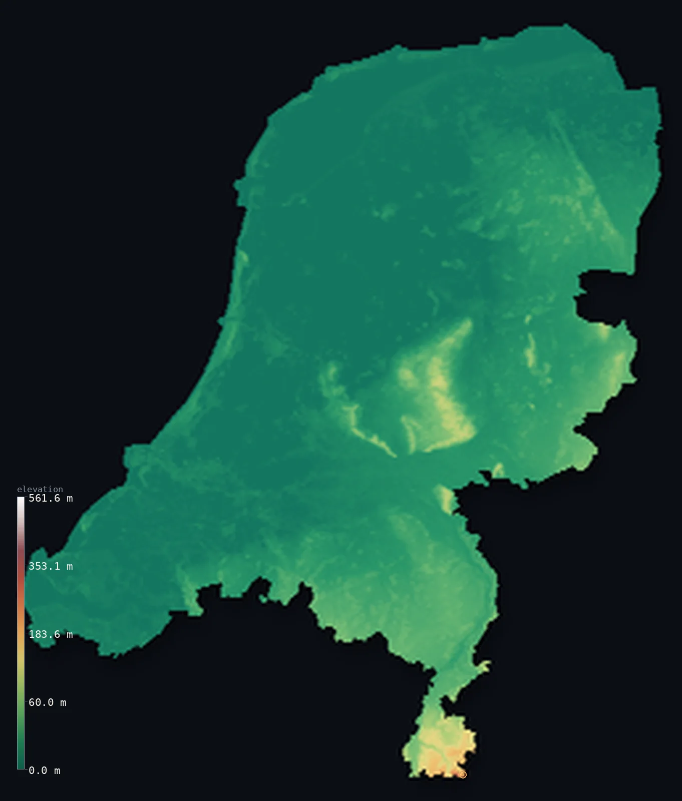
Netherlands’s highest point is Vaalserberg at 1,056 ft (322 m); its lowest is Zuidplaspolder at −22 ft (−6.8 m); the mean elevation is 30 ft (9.1 m).
The Netherlands is the great exception among nations: a country whose land largely lies at or below sea level, its highest point — the Vaalserberg, at 1,056 ft (322 m) — barely a hill by the standards of most countries. Roughly a quarter of it sits below sea level, and about half was reclaimed from water by human hands. The name says it plainly: the Low Countries.
- Highest point📚
- 1,056 ft322 m
- The highest point of the European Netherlands is the Vaalserberg at 1,056 ft (322 m) — a wooded hilltop where the country meets Belgium and Germany, and a summit so modest that in most nations it would not register as high ground at all. (The wider Kingdom rises higher overseas, to 2,910 ft / 887 m at Mount Scenery on the Caribbean island of Saba.)
- Lowest point📚
- −22 ft−6.8 m
- The country's lowest ground lies at Zuidplaspolder, about 22 ft (6.76 m) below sea level — the lowest point in the entire European Union. It is not a natural valley but a drained lake bed, dry land only because pumps keep the water out.
- Mean elevation⚙
- 30 ft9.1 m
- The mean elevation of the Netherlands computed from the GLO-30 model is just 30 ft (9.1 m) — barely above the tide. For a country this size to average so close to sea level is almost unique; there is simply very little high ground anywhere to lift the figure.
- Median elevation⚙
- 5 ft1.6 m
- Half of the Netherlands lies below 5 ft (1.6 m) above sea level — a median so low it is essentially at the waterline, a plainer statement than any map of how flat and low this country truly is.
- Elevation range📚
- 1,079 ft329 m
- From the drained polders at 22 ft (6.76 m) below sea level to the Vaalserberg's 1,056 ft (322 m), the entire vertical range of the European Netherlands is under 1,100 ft — less than the height of a single skyscraper, and a span most countries cover within one hillside.
- Above 50 m (164 ft)⚙
- 3%
- Almost none of the Netherlands stands high: only about 2.7% of the country rises above even 165 ft (50 m), and virtually all of that low rise is in the far southeast, toward the hills of Limburg.
- Official area📚
- 16,041 mi²41,545 km²
- The Netherlands covers about 16,040 sq mi (41,545 sq km) — and remarkably, much of that land did not exist in its present form until people made it, draining lakes and seas and holding back the water behind dikes.
- Forest cover📚
- 11%
- Only about 11% of the Netherlands is forested — one of the lowest shares in Europe — because this is among the most intensively used and densely populated landscapes on Earth, its flat ground long ago turned to farmland, pasture, and city.
Highest and lowest points
The highest point of the European Netherlands is the Vaalserberg, 1,056 ft (322 m), at the Drielandenpunt — the tripoint where the Netherlands, Belgium, and Germany meet. It is a gentle wooded rise, not a mountain, and its modesty is the point: this is the high ground of a country defined by its lowness. The Kingdom of the Netherlands reaches far higher overseas, at Mount Scenery (2,910 ft / 887 m) on the Caribbean island of Saba, which lies outside this map.
source ↗The lowest point of the Netherlands is Zuidplaspolder, a drained lake bed near Rotterdam lying about 22 ft (6.76 m) below sea level — the lowest land in the European Union. It stays dry only through constant pumping; without the dikes and pumps that ring it, the sea and rivers would reclaim it within days. It is the extreme example of the Dutch relationship with water — land held below the waves by engineering rather than geology.
source ↗Netherlands at a glance
About a quarter of the Netherlands lies below sea level, and roughly half the country was reclaimed from lakes, marshes, and the sea.
source ↗The lowest point, Zuidplaspolder, sits about 6.76 m below sea level — the lowest land in the European Union.
source ↗The highest point of the European Netherlands, the Vaalserberg, reaches only 322 m — while the Kingdom's true summit, Mount Scenery on Saba, stands at 887 m in the Caribbean.
source ↗In 1932 the Dutch closed off an entire inland sea, the Zuiderzee, behind a 32-km dam, converting it over time into the freshwater IJsselmeer and new land.
source ↗The country's name — the Netherlands, the 'Low Countries' — is simply a description of its elevation.
source ↗
Elevation profile of Netherlands
The largest share of land, 66%, falls in the 0–25 m band, and 100% of the territory lies below 500 m (1,640 ft).
- below sea level23%
- 0–10 m (0–33 ft)48%
- 10–50 m (33–164 ft)27%
- above 50 m (164 ft)3%
Highest peaks of Netherlands
| Peak | Elevation | Range | Note |
|---|---|---|---|
| Mount Scenery (Saba)↗ | 2,910 ft887 m | Saba, Caribbean | Highest point of the whole Kingdom of the Netherlands — a volcano on Saba, added in 2010. Outside the European territory this map renders. |
| Vaalserberg↗ | 1,056 ft322 m | Limburg hills | Highest point of the European Netherlands, at the Drielandenpunt tripoint with Belgium and Germany. |
| Vrouwenheide↗ | 827 ft252 m | Limburg hills | One of the higher hills of southern Limburg, the Netherlands' only genuinely hilly region. |
| Hulsberg / Veluwe high ground↗ | 361 ft110 m | Veluwe | The Veluwe, a glacial sand ridge in the centre-east, is the largest area of higher ground outside Limburg, reaching around 110 m. |
The three faces of the Dutch landscape
The polders and reclaimed land (west and north)
Most of the western and northern Netherlands is polder — flat, low land drained and held dry behind dikes. Much of it lies below sea level, laced with canals and dotted with the pumping stations (once windmills) that keep it drained. This is the engineered heart of the country, including nearly all of its reclaimed ground.
The sandy east and the Veluwe (centre and east)
East of the polders the land rises slightly onto older, sandier ground left by Ice Age glaciers and rivers. The Veluwe, a low ridge of sand and heath and the country's largest area of woodland, is the closest the central Netherlands comes to hills — rising only to a few hundred feet.
The Limburg hills (southeast)
Only in the far southeast, in Limburg, does the Netherlands reach genuine high ground. Here the land climbs onto the edge of a low plateau toward the Vaalserberg (1,056 ft / 322 m), the country's European high point — gentle, wooded hills that feel like another country entirely.
How to read this map
Color shows elevation; the raised relief shows real terrain. On a country this flat, the color bands are tuned to the low range — greens and blues at and below sea level, rising through the faint browns of the Limburg hills.
The 3D relief is the actual GLO-30 elevation data, exaggerated vertically far more than usual so that a country whose whole range is under 1,100 ft shows any shape at all; the ×N relief slider controls how much. Tap anywhere on the map to read that point's exact elevation.
City elevations in Netherlands
Dutch cities sit low almost without exception — most within a few feet of sea level, many below it, protected by the same dikes and pumps that hold the polders dry. Only in the hillier southeast does the land rise beneath them.
| City | Population | Elevation |
|---|---|---|
| RotterdamEurope's largest port, on the Rhine-Meuse delta at barely above sea level ↗ | 868,135 | 20 ft6 m |
| Amsterdamcapitalthe capital, built on reclaimed marsh and laced with canals, near sea level ↗ | 741,636 | 36 ft11 m |
| Utrechtin the low central Netherlands, just above sea level ↗ | 376,435 | 36 ft11 m |
| Groningenthe main city of the low, flat north ↗ | 244,807 | 43 ft13 m |
| Eindhoven | 235,691 | 69 ft21 m |
| Tilburg | 221,947 | 56 ft17 m |
| Nijmegenon slightly higher ground above the Waal, one of the country's oldest cities ↗ | 177,359 | 79 ft24 m |
| Enschedein the sandier, higher east near the German border - among the country's more elevated cities ↗ | 153,655 | 154 ft47 m |
| Apeldoorn | 136,670 | 59 ft18 m |
| Zwolleon the low ground of the IJssel valley in the centre-east ↗ | 129,840 | 26 ft8 m |
Elevation sampled at each city centre from the Copernicus GLO-30 model. Cities and population from GeoNames (CC-BY 4.0).
Netherlands in comparison
Netherlands's terrain rises 1,079 ft (329 m) from Zuidplaspolder, 22 ft (6.8 m) below sea level to Vaalserberg — about 4% of the height of Mount Everest, the world's highest point at 29,032 ft (8,849 m).
- Belgium's mean elevation is 515 ft — 485 ft higher; its high point, Signal de Botrange, reaches 2,277 ft (694 m), 1,220 ft above. Belgium elevation map →
- Denmark's mean elevation is 102 ft — 73 ft higher; its high point, Møllehøj, reaches 561 ft (171 m), 495 ft below. Denmark elevation map →
- Slovenia's mean elevation is 1,860 ft — 1,830 ft higher; its high point, Triglav, reaches 9,396 ft (2,864 m), 8,340 ft above. Slovenia elevation map →
Frequently asked questions
What is the highest point in the Netherlands?
- The Vaalserberg, 1,056 ft (322 m), in the far southeast where the country meets Belgium and Germany - the high point of the European Netherlands. (The Kingdom's overseas high point is Mount Scenery, 887 m, on Saba in the Caribbean.)
What is the lowest point in the Netherlands?
- Zuidplaspolder, about 22 ft (6.76 m) below sea level near Rotterdam - the lowest land in the European Union.
How much of the Netherlands is below sea level?
- About a quarter of the country lies below sea level, and roughly half was reclaimed from water - the reason for the country's elaborate system of dikes and pumps.
Why is the Netherlands so flat and low?
- It sits on the low delta where the Rhine, Meuse, and Scheldt rivers meet the North Sea - a landscape of deposited sediment and drained wetland, with almost no natural high ground.
Is this a topographic, relief, contour, or elevation map of the Netherlands?
- They describe the same thing - terrain height. This page renders the country's actual elevation surface in interactive 3D and reports the statistics computed from it.
About this map
The terrain is rendered from the Copernicus GLO-30 digital elevation model (ESA), masked to the NLD-ADM0 boundary from geoBoundaries (gbOpen). Elevation statistics are computed directly from the model; peak names and researched facts are sourced and cited. See the methodology for the full pipeline.
Our area-weighted mean, computed from the Copernicus GLO-30 model, is 30 ft (9.1 m); the figure commonly cited elsewhere is 98 ft (30 m) (CIA World Factbook). The Netherlands is among the flattest countries on Earth — about a quarter of it lies below sea level — so its true average height is only a few metres above the tide; the higher figure cited elsewhere reflects a different method, and this page reports the area-weighted mean computed from the Copernicus GLO-30 model.
Surveyed national figures: official area · forest cover · high point.
Rendered from Copernicus GLO-30 (ESA, 2021 release), boundaries from geoBoundaries. Generated 2026-06-25.
Bordering countries · 2
Netherlands shares a land border with these countries — open any one to compare its terrain and highest point.