Belgium Elevation Map — Topographic & 3D Terrain
Explore the terrain of Belgium in interactive 3D, built from Copernicus GLO-30 satellite elevation data — the North Sea coast and Flanders plain rising to the low Ardennes hills. Drag to rotate, scroll to zoom, and tap any point to read its elevation.
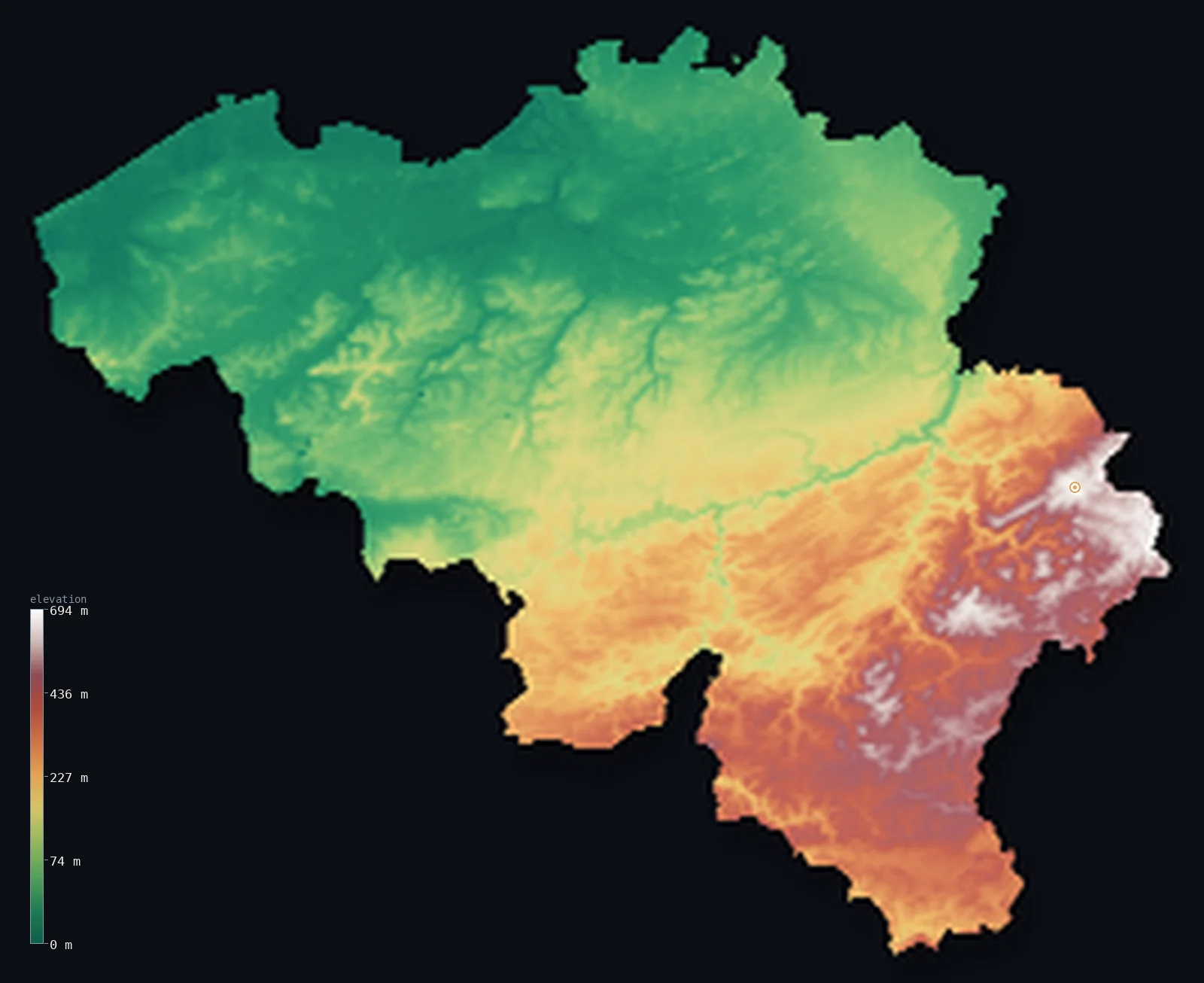
Belgium’s highest point is Signal de Botrange at 2,277 ft (694 m); its lowest is North Sea at 0 ft (0 m); the mean elevation is 515 ft (157 m).
Belgium tilts gently from sea to hills. In the northwest lie the flat coastal plain of Flanders and the North Sea shore — low, and in a few polders just below sea level. From there the land rises slowly southeastward across low central plateaus to the Ardennes, a region of forested hills and high moorland in the southeast where Signal de Botrange, the highest point, reaches just 2,277 ft (694 m). It is a country of lowland and low upland, with only about a third of it above 656 ft (200 m) and no mountains at all.
- Highest point📚
- 2,277 ft694 m
- Belgium's highest point is Signal de Botrange at 2,277 ft (694 m), in the High Fens of the Ardennes in the far southeast — not a peak but the high point of a broad upland moor, the raised bog plateau of the Hautes Fagnes. It is the summit of a country with no mountains, whose highest ground is gentle upland rather than mountain.
- Lowest point📚
- 0 ft0 m
- Belgium's lowest point is the North Sea at sea level, along the short northwestern coast — though just behind it a few reclaimed coastal polders lie slightly below sea level, kept dry by drainage, a small echo of the engineered lowlands of the neighbouring Netherlands.
- Mean elevation⚙
- 515 ft157 m
- Computed from the GLO-30 model, Belgium's mean elevation is 515 ft (157 m) — low, as befits a country of lowland and low plateau: the Flanders plain and the central lowlands cover most of it, and only the modest Ardennes hills of the southeast rise much above.
- Median elevation⚙
- 285 ft87 m
- Half of Belgium lies below 285 ft (87 m) — a low figure that fits a mostly flat country: the coastal plain and the central lowlands dominate, and even the Ardennes, the one upland, is hill and plateau rather than mountain, never rising to real height.
- Elevation range📚
- 2,277 ft694 m
- Belgium's whole vertical range is only about 2,280 ft (694 m) — from the North Sea to the modest moor of Signal de Botrange, with no high ground anywhere between: the country rises gently and never far.
- Official area📚
- 11,787 mi²30,528 km²
- Belgium covers about 11,800 sq mi (30,528 sq km) — a small country in northwestern Europe, low and flat in the north along the North Sea and the Flanders plain, rising gently to the Ardennes hills in the southeast.
- Forest cover📚
- 22.7%
- About 22.7% of Belgium is forested — most of it in the Ardennes, whose hills carry extensive woodland; the northern plains are among the most densely populated and intensively used land in Europe, with little forest.
Highest and lowest points
Belgium's highest point is Signal de Botrange, 2,277 ft (694 m), in the far southeast — and it is not a mountain or even really a hill, but the highest point of the Hautes Fagnes (High Fens), a broad upland of raised peat bog and moorland in the Ardennes. The ground here is gentle and open rather than steep, a plateau of heath and marsh; a stone staircase was built at the summit in 1923 to lift visitors symbolically to the 700 m mark the natural ground doesn't quite reach. It is the modest roof of a country with no mountains.
source ↗Belgium's lowest point is the North Sea at sea level, along a short coast of beaches and dunes in the northwest. Just inland lie the polders — coastal farmland reclaimed from marsh and sea, some of it slightly below sea level and kept dry by dikes and drainage, as in the neighbouring Netherlands, though Belgium's share is far smaller. From this low, flat coast the country rises gradually inland, but never far: even the distant Ardennes are only hills.
source ↗Belgium at a glance
Belgium's highest point, Signal de Botrange, is only 694 m — so a stone staircase was built at the summit in 1923 to let visitors stand at a symbolic 700 m.
source ↗Botrange is the highest point not just of Belgium but of the entire Benelux — there is nothing higher in Belgium, the Netherlands or Luxembourg.
source ↗Belgium's terrain shifts dramatically over a short distance — from sea-level polders in the northwest to a 300-million-year-old Hercynian massif in the Ardennes southeast.
source ↗Botrange only became Belgium's high point after 1919, when Belgium gained the Eastern Cantons from Germany under the Treaty of Versailles — before that the title belonged to the lower Baraque Michel.
source ↗Much of the Belgian coast is polder — land reclaimed from the sea and kept dry by dikes — leaving parts of the country at or below sea level, much like the neighbouring Netherlands.
source ↗A 50 m tower on the summit relays stock-market data by microwave between London and Frankfurt, shaving milliseconds off the transmission for high-frequency trading.
source ↗The forested Ardennes were twice used by German armies to invade France — in 1940 and again in the 1944 Battle of the Bulge — because the terrain was thought impassable to tanks.
source ↗
Elevation profile of Belgium
The largest share of land, 52%, falls in the 0–100 m band, and 96% of the territory lies below 500 m (1,640 ft).
- below 500 m (1,640 ft)96%
- 500–1,000 m4%
Highest peaks of Belgium
| Peak | Elevation | Range | Note |
|---|---|---|---|
| Signal de Botrange↗ | 2,277 ft694 m | High Fens (Ardennes) | Highest point of Belgium, the Ardennes and the Benelux — a plateau top in the High Fens. |
| Weißer Stein (Belgian side)↗ | 2,274 ft693 m | High Fens (Ardennes) | A high point on the German border in the High Fens; a 2010 claim it topped Botrange was rejected by Belgium's NGI. |
| Baraque Michel↗ | 2,211 ft674 m | High Fens (Ardennes) | A High Fens summit that was Belgium's highest point before the Eastern Cantons were annexed in 1919. |
| Kemmelberg↗ | 522 ft159 m | Flemish hills | A hill in West Flanders famous from the Gent–Wevelgem cycle race — one of the few rises in the flat north. |
| Koppenberg↗ | 253 ft77 m | Flemish Ardennes | A short, steep, cobbled climb in the Flemish Ardennes, famous from the Tour of Flanders. |
Belgium from the North Sea coast to the Ardennes
The coast and the Flanders plain
The northwest of Belgium is flat lowland — the short North Sea coast of beaches, dunes, and reclaimed polders (some just below sea level), and behind it the Flanders plain, low, level, and among the most densely populated farmland in Europe. This is the country's lowest ground.
The central plateaus
Across the middle of the country the land rises gently into low plateaus — the fertile loam belt of central Belgium, rolling agricultural country between the northern plain and the southern hills, holding Brussels and much of the population. Low upland, neither flat nor high.
The Ardennes (southeast)
The southeast is the Ardennes — a region of forested hills, deep river valleys, and open high moorland rising to Signal de Botrange in the Hautes Fagnes. Shared with France and Luxembourg, it is the highest, wildest, and least populated part of Belgium, though its heights are hills and plateau, not mountains.
How to read this map
Color shows elevation; the raised relief shows real terrain. On this map Belgium tilts gently from northwest to southeast — the low green Flanders plain and the North Sea coast in the northwest, rising through the central plateaus to the browns of the Ardennes hills in the southeast, the country's only real upland.
The 3D relief is the actual GLO-30 elevation data, exaggerated vertically so that even a country this low shows its gentle slope; the ×N relief slider controls how much. Tap anywhere to read that point's exact elevation.
City elevations in Belgium
Belgium's cities cluster in the lower north and centre — Brussels in the central plateau, Antwerp and Ghent on the northern plain, Bruges near the coast, with Liège and Charleroi in the valleys toward the Ardennes. Nearly all sit low; the southeast holds fewer, smaller towns.
| City | Population | Elevation |
|---|---|---|
| Brusselscapitalthe capital, on the central plateau of the country ↗ | 1,019,022 | 85 ft26 m |
| Antwerpon the Scheldt in the northern plain, a major port near the coast ↗ | 529,247 | 43 ft13 m |
| Gentat the meeting of the Scheldt and Leie in the Flanders plain ↗ | 265,086 | 39 ft12 m |
| Charleroion the Sambre in the industrial south, toward the Ardennes ↗ | 200,132 | 436 ft133 m |
| Liègeon the Meuse in the east, toward the Ardennes ↗ | 195,278 | 217 ft66 m |
| Bruggenear the North Sea coast in the northwest, in the Flanders polders ↗ | 118,509 | 43 ft13 m |
| Namurwhere the Sambre meets the Meuse, at the edge of the Ardennes ↗ | 110,939 | 295 ft90 m |
| Leuvenon the Dyle in the central plateau, east of Brussels ↗ | 101,032 | 98 ft30 m |
| Monsin the southwest, near the French border ↗ | 95,299 | 174 ft53 m |
| Hasseltin the Campine lowland of the northeast ↗ | 77,651 | 131 ft40 m |
Elevation sampled at each city centre from the Copernicus GLO-30 model. Cities and population from GeoNames (CC-BY 4.0).
Belgium in comparison
Belgium's terrain rises 2,277 ft (694 m) from sea level to Signal de Botrange — about 8% of the height of Mount Everest, the world's highest point at 29,032 ft (8,849 m).
- Netherlands's mean elevation is 30 ft — 485 ft lower; its high point, Vaalserberg, reaches 1,056 ft (322 m), 1,220 ft below. Netherlands elevation map →
- Luxembourg's mean elevation is 1,152 ft — 636 ft higher; its high point, Kneiff, reaches 1,837 ft (560 m), 440 ft below. Luxembourg elevation map →
- Denmark's mean elevation is 102 ft — 413 ft lower; its high point, Møllehøj, reaches 561 ft (171 m), 1,716 ft below. Denmark elevation map →
Frequently asked questions
What is the highest point in Belgium?
- Signal de Botrange, 2,277 ft (694 m), in the Hautes Fagnes of the Ardennes — not a peak but the high point of a broad upland moor, in a country with no mountains.
What is the lowest point in Belgium?
- The North Sea at sea level, on the northwestern coast — though a few reclaimed coastal polders just inland lie slightly below sea level, kept dry by drainage.
What is the average elevation of Belgium?
- Computed from the Copernicus GLO-30 model, the area-weighted mean is 515 ft (157 m) — low, because Belgium is mostly the Flanders plain and central lowlands, with only the modest Ardennes hills rising above.
Does Belgium have mountains?
- No — its highest point, Signal de Botrange, is only 694 m, and even that is upland moor rather than mountain. Belgium is a country of lowland and low hills, rising gently from the North Sea coast to the Ardennes.
What are the Ardennes?
- The forested hills and high moorland of southeastern Belgium, shared with France and Luxembourg — the country's highest and wildest region, holding Signal de Botrange, though its heights are hills and plateau rather than mountains.
Is this a topographic, relief, contour, or elevation map of Belgium?
- They describe the same thing — terrain height. This page renders the country's actual elevation surface in interactive 3D and reports the statistics computed from it.
About this map
The terrain is rendered from the Copernicus GLO-30 digital elevation model (ESA), masked to the BEL-ADM0 boundary from geoBoundaries (gbOpen). Elevation statistics are computed directly from the model; peak names and researched facts are sourced and cited. See the methodology for the full pipeline.
Our area-weighted mean, computed from the Copernicus GLO-30 model, is 515 ft (157 m); the figure commonly cited elsewhere is 594 ft (181 m) (CIA World Factbook). Belgium rises from a flat North Sea coast through a central plateau to the Ardennes uplands in the southeast, so its mean elevation is modest — the high Ardennes pull it up while the coastal polders and plains keep most of the country low; the page reports the area-weighted figure computed from the Copernicus GLO-30 model.
Surveyed national figures: official area · forest cover · high point.
Rendered from Copernicus GLO-30 (ESA, 2021 release), boundaries from geoBoundaries. Generated 2026-06-22.
Bordering countries · 4
Belgium shares a land border with these countries — open any one to compare its terrain and highest point.