Germany Elevation Map — Topographic & 3D Terrain
Explore the terrain of Germany in interactive 3D, built from Copernicus GLO-30 satellite elevation data — a country that climbs like a staircase from the northern plain to the Alps. Drag to rotate, scroll to zoom, and tap any point to read its elevation.
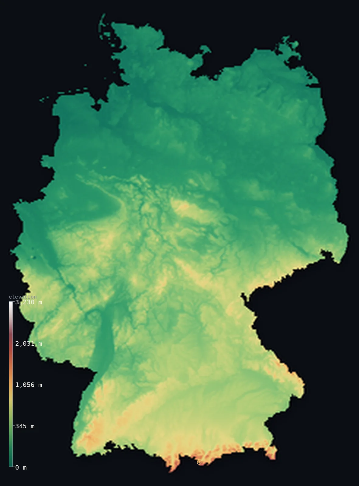
Germany’s highest point is Zugspitze at 9,718 ft (2,962 m); its lowest is Neuendorf-Sachsenbande (Wilstermarsch) at −13 ft (−4 m); the mean elevation is 869 ft (265 m).
Germany rises like a staircase from north to south. The flat North German Plain along the coast gives way to the rolling forested uplands of the centre, and finally, in the far south, to a single narrow strip of the Alps — where the country reaches its highest point, the Zugspitze, at 9,718 ft (2,962 m). Most of Germany is low: about 84% lies below 500 m (1,640 ft).
- Highest point📚
- 9,718 ft2,962 m
- Germany's highest point is the Zugspitze at 9,718 ft (2,962 m), on the Austrian border in the far south — the country's only genuinely Alpine summit, reached today by cog railway and cable car, with a view over four countries from the top.
- Lowest point📚
- −13 ft−4 m
- Germany's lowest natural point is at Neuendorf-Sachsenbande in the northern marshes, about 13 ft (4 m) below sea level — reclaimed coastal lowland in the flat country near the North Sea.
- Mean elevation⚙
- 869 ft265 m
- Germany's mean elevation computed from the GLO-30 model is 869 ft (265 m) — a low figure that fits a country whose north is broad plain, whose centre is low upland, and whose high mountains are confined to a single Alpine corner.
- Median elevation⚙
- 673 ft205 m
- Half of Germany lies below 673 ft (205 m), close to the mean — a sign of how evenly the country tilts, rising gradually from the northern coast rather than jumping between extremes.
- Elevation range📚
- 9,731 ft2,966 m
- From the northern marshes to the Zugspitze, Germany spans about 9,700 ft — but almost the entire climb happens at the very southern edge, where the land finally reaches the Alps after hundreds of kilometres of plain and upland.
- Above 1,000 m (3,281 ft)⚙
- 1%
- Only about 1% of Germany rises above 1,000 m (3,281 ft) — the Bavarian Alps in the far south and a few high points of the central uplands. The overwhelming majority of the country is low.
- Official area📚
- 137,847 mi²357,022 km²
- Germany covers about 138,000 sq mi (358,000 sq km) in the heart of Europe — a densely populated country of coastal plain, forested hills, and the great river arteries of the Rhine, Elbe, and Danube.
- Forest cover📚
- 32.7%
- About 33% of Germany is forested — from the fabled Black Forest and Bavarian Forest of the south to the wooded central uplands like the Harz — much of it managed woodland woven through a crowded, cultivated landscape.
Highest and lowest points
Germany's highest point is the Zugspitze, 9,718 ft (2,962 m), on the border with Austria in the Bavarian Alps — the only part of Germany that reaches genuine Alpine height. Its summit, now served by cog railway and cable car, looks out over Germany, Austria, Italy, and Switzerland. It stands at the very southern edge of the country, the top of the long rise from the northern plain.
source ↗Germany's lowest natural point is at Neuendorf-Sachsenbande in the Wilstermarsch, near the Elbe estuary, about 13 ft (4 m) below sea level. It is reclaimed marshland in the flat far north, where the land behind the North Sea dikes dips below the tide — a small, quiet low point in a country whose real drama is all in the south.
source ↗Germany at a glance
Germany's highest point, the Zugspitze (2,962 m), stands on the Austrian border in the far south - the country's only genuinely Alpine summit.
source ↗Germany rises from north to south like a staircase - the flat North German Plain, then the central uplands, then a single strip of Alps - and about 84% of it lies below 500 m.
source ↗The North German Plain along the coast is so low that its reclaimed marshes dip below sea level behind protective dikes.
source ↗The central uplands - the Harz, the Rhenish Massif, the Ore Mountains - are low, ancient, forested ranges that divide the northern plain from the southern highlands.
source ↗Only about 1% of Germany rises above 1,000 m, almost all of it in the Bavarian Alps of the far south.
source ↗Germany's great rivers - the Rhine, the Elbe, the Danube - cut through the uplands and plains and have shaped its cities and borders for centuries.
source ↗
Elevation profile of Germany
The largest share of land, 49%, falls in the 0–200 m band, and 84% of the territory lies below 500 m (1,640 ft).
- below 500 m (1,640 ft)84%
- 500–1,000 m15%
- 1,000–2,000 m1%
- above 2,000 m (6,562 ft)<1%
Highest peaks of Germany
| Peak | Elevation | Range | Note |
|---|---|---|---|
| Zugspitze↗ | 9,718 ft2,962 m | Bavarian Alps / Wetterstein (Austria border) | Highest point of Germany, on the Austrian border above Garmisch-Partenkirchen. |
| Hochwanner↗ | 9,009 ft2,746 m | Bavarian Alps / Wetterstein | The second-highest mountain in Germany, in the Wetterstein range near the Zugspitze. |
| Watzmann (Middle Peak)↗ | 8,901 ft2,713 m | Berchtesgaden Alps | A famous triple-peaked mountain in the Berchtesgaden Alps of southeastern Bavaria. |
| Feldberg↗ | 4,898 ft1,493 m | Black Forest (southwest) | The highest peak of the Black Forest - and the highest German mountain outside the Alps. |
| Brocken↗ | 3,743 ft1,141 m | Harz (central) | The highest point of the Harz and of northern-central Germany, famous in folklore (Walpurgis Night). |
Germany's three steps
The North German Plain
The northern third of Germany is flat lowland — the North German Plain — stretching from the Dutch border to Poland along the North Sea and Baltic coasts. Reclaimed and dike-protected near the coast, it holds the country's lowest ground, dipping below sea level in the coastal marshes.
The Central Uplands
Across the middle of the country runs a belt of low, forested mountains — the Rhenish Massif, the Harz, the Thuringian Forest, the Ore Mountains — rarely above 1,000 m. Ancient and rounded, they separate the northern plain from the higher south.
The South and the Alps
Southern Germany rises onto higher plateaus and the foothills of the Alps, ending at the Bavarian Alps along the Austrian border, where the Zugspitze marks the country's summit. This is the top of the staircase, Germany's only truly Alpine ground.
How to read this map
Color shows elevation; the raised relief shows real terrain. On this map Germany reads as a green plain in the north shading up through the browns of the central uplands to a thin white line of Alps in the far south.
The 3D relief is the actual GLO-30 elevation data, exaggerated vertically so the gentle rise and the Alpine edge both show; the ×N relief slider controls how much. Tap anywhere to read that point's exact elevation.
City elevations in Germany
German cities rise gently with the land - Hamburg and Berlin low in the northern plain, and Munich noticeably higher on the southern approach to the Alps. None sits truly high, but the north-to-south climb shows in their elevations.
| City | Population | Elevation |
|---|---|---|
| Berlincapitalthe capital, on the low, sandy North German Plain at about 40 m ↗ | 3,426,354 | 138 ft42 m |
| Hamburgthe great northern port on the Elbe, near sea level ↗ | 1,973,896 | 46 ft14 m |
| Munichon the elevated southern plateau approaching the Alps, at about 520 m - the highest of the big cities ↗ | 1,505,005 | 1,726 ft526 m |
| Köln | 1,024,621 | 187 ft57 m |
| Frankfurt am Main | 650,000 | 364 ft111 m |
| Stuttgart | 612,663 | 837 ft255 m |
| Dortmund | 588,462 | 302 ft92 m |
| Dresden | 564,904 | 384 ft117 m |
| Bremen | 546,501 | 69 ft21 m |
| Nuremberg | 515,543 | 997 ft304 m |
Elevation sampled at each city centre from the Copernicus GLO-30 model. Cities and population from GeoNames (CC-BY 4.0).
Germany in comparison
Germany's terrain rises 9,731 ft (2,966 m) from Neuendorf-Sachsenbande (Wilstermarsch), 13 ft (4 m) below sea level to Zugspitze — about 34% of the height of Mount Everest, the world's highest point at 29,032 ft (8,849 m).
- Austria's mean elevation is 3,127 ft — 2,257 ft higher; its high point, Grossglockner, reaches 12,461 ft (3,798 m), 2,743 ft above. Austria elevation map →
- Poland's mean elevation is 571 ft — 299 ft lower; its high point, Rysy, reaches 8,199 ft (2,499 m), 1,519 ft below. Poland elevation map →
- France's mean elevation is 1,122 ft — 253 ft higher; its high point, Mont Blanc, reaches 15,768 ft (4,806 m), 6,050 ft above. France elevation map →
Frequently asked questions
What is the highest point in Germany?
- The Zugspitze, 9,718 ft (2,962 m), on the Austrian border in the Bavarian Alps - the country's only genuinely Alpine summit.
What is the lowest point in Germany?
- Neuendorf-Sachsenbande in the northern marshes, about 13 ft (4 m) below sea level - reclaimed coastal lowland near the North Sea.
Why does Germany get higher toward the south?
- Germany rises like a staircase - the flat North German Plain in the north, the central forested uplands, and finally the Alps in the far south, where it reaches its highest point.
How mountainous is Germany?
- Only lightly - about 84% of the country lies below 500 m, and just 1% above 1,000 m, almost all of that in the Bavarian Alps.
What is the average elevation of Germany?
- Computed from the GLO-30 model, Germany's area-weighted mean is 869 ft (265 m) - low, fitting a country of northern plain and central upland with its mountains confined to one Alpine corner.
Is this a topographic, relief, contour, or elevation map of Germany?
- They describe the same thing - terrain height. This page renders the country's actual elevation surface in interactive 3D and reports the statistics computed from it.
About this map
The terrain is rendered from the Copernicus GLO-30 digital elevation model (ESA), masked to the DEU-ADM0 boundary from geoBoundaries (gbOpen). Elevation statistics are computed directly from the model; peak names and researched facts are sourced and cited. See the methodology for the full pipeline.
Our area-weighted mean, computed from the Copernicus GLO-30 model, is 869 ft (265 m); the figure commonly cited elsewhere is 863 ft (263 m) (CIA World Factbook). Germany steps down from the high Bavarian Alps in the far south, through the central uplands, to the flat North European Plain along the North Sea and Baltic - so most of the country is low or rolling and the mean elevation is moderate; the page reports the area-weighted figure computed from the Copernicus GLO-30 model.
Surveyed national figures: official area · forest cover · high point.
Rendered from Copernicus GLO-30 (ESA, 2021 release), boundaries from geoBoundaries. Generated 2026-06-23.
Bordering countries · 9
Germany shares a land border with these countries — open any one to compare its terrain and highest point.