Czechia Elevation Map — Topographic & 3D Terrain
Explore the terrain of Czechia in interactive 3D, built from Copernicus GLO-30 satellite elevation data — a high inland basin ringed by low mountains. Drag to rotate, scroll to zoom, and tap any point to read its elevation.
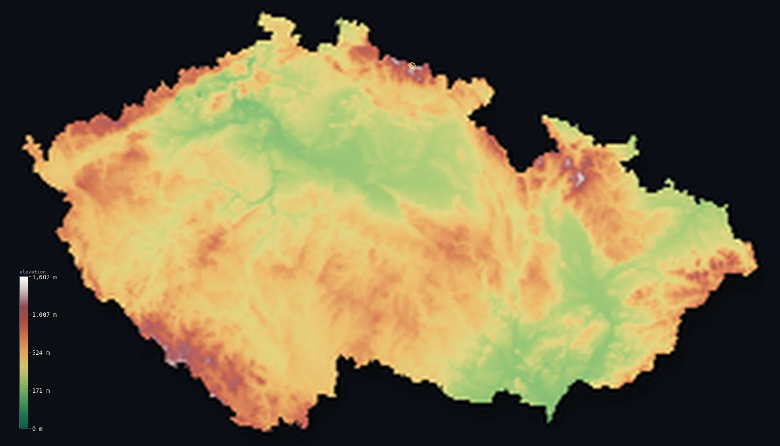
Czechia’s highest point is Sněžka at 5,259 ft (1,603 m); its lowest is Elbe (Labe) River at Hřensko at 377 ft (115 m); the mean elevation is 1,486 ft (453 m).
Czechia is a bowl. The historic land of Bohemia is a broad, gently rolling plateau enclosed on almost every side by low mountain ranges — the Ore Mountains, the Bohemian Forest, the Giant Mountains — that form a natural rim around the interior. The rivers gather in the middle and escape north through the Elbe. The highest point sits on that enclosing edge, at Sněžka, 5,259 ft (1,603 m) on the Polish border; but the country has no truly high ground, and most of it is undulating upland between 650 and 2,300 ft.
- Highest point📚
- 5,259 ft1,603 m
- Czechia's highest point is Sněžka at 5,259 ft (1,603 m), in the Giant Mountains (Krkonoše) on the northeastern border with Poland — a rounded, weather-beaten summit on the rim of the Bohemian basin, the highest point of a country that is otherwise gentle upland rather than true mountain.
- Lowest point📚
- 377 ft115 m
- Czechia's lowest point is where the river Elbe leaves the country for Germany, at about 377 ft (115 m) in the north — the single outlet through which the waters of enclosed Bohemia drain away to the North Sea.
- Mean elevation⚙
- 1,486 ft453 m
- Computed from the GLO-30 model, Czechia's mean elevation is 1,486 ft (453 m) — a moderate figure for a landlocked country that is essentially a raised inland bowl: undulating plateau and hill country throughout, ringed but not filled by mountains.
- Median elevation⚙
- 1,453 ft443 m
- Half of Czechia lies above 1,453 ft (443 m) — close to the mean, and the mark of a remarkably even country: a broad upland with little extreme in either direction, its low points and its modest heights never far from the middle.
- Elevation range📚
- 4,882 ft1,488 m
- From the Elbe's exit to the summit of Sněžka, Czechia spans only about 4,880 ft — a modest range, since the country is an enclosed upland rather than a land of true mountains; its high point is a border summit on the rim, not a peak in a high interior.
- Above 1,000 m (3,281 ft)⚙
- 1%
- Only about 1% of Czechia rises above 1,000 m (3,281 ft) — just the crests of the border ranges, the Giant Mountains, the Ore Mountains, and the Bohemian Forest. The interior is lower, gentle plateau and hill.
- Official area📚
- 30,451 mi²78,867 km²
- Czechia covers about 30,500 sq mi (78,867 sq km) — a landlocked country in central Europe, made up of the basin of Bohemia in the west and the lower hills and lowlands of Moravia in the east, walled by low mountains.
- Forest cover📚
- 34.7%
- About 34.7% of Czechia is forested — over a third of the country, much of it on the border mountains and the hills, from the spruce forests of the Bohemian Forest and the Giant Mountains to the mixed woodland of the interior uplands.
Highest and lowest points
Czechia's highest point is Sněžka, 5,259 ft (1,603 m), in the Giant Mountains (Krkonoše) on the border with Poland. It is a rounded, often cloud-wrapped summit — its name means 'snowy' — standing on the northeastern rim of the Bohemian basin. Though it is the highest point in the country, it is a modest one: Czechia has no high mountains, only the low ranges that enclose its plateau, and Sněžka is the tallest point of that frame. It sits directly on the frontier; the Polish side rises to it too, though Poland's own high mountains, the Tatras, are far higher and lie elsewhere.
source ↗Czechia's lowest point is where the river Elbe crosses out of the country into Germany, in the north, at about 377 ft (115 m). It is a fitting low point for a country shaped like a bowl: almost all of Bohemia's rivers — the Vltava through Prague, and the others — gather into the Elbe, which then cuts north through a gap in the enclosing mountains and carries the country's water away to the North Sea. Even this lowest ground is well above sea level, in a landlocked country whose floor is a raised plateau.
source ↗Sněžka is a border summit: its peak lies just outside the generalized Czechia boundary, so the highest fully in-territory land pixel in the model is 5,256 ft (1,602 m). The headline figure above is the surveyed elevation of the recognised national high point.
Czechia at a glance
Czechia's highest point, Sněžka (1,603 m), stands on the rim of the Bohemian basin on the Polish border — the country has no truly high mountains, only the low ranges that enclose its plateau.
source ↗Bohemia, the western two-thirds of Czechia, is a broad basin shut in by low mountain ranges — the Ore Mountains, the Bohemian Forest, and the Giant Mountains — forming a natural wall.
source ↗Almost all of Bohemia's rivers gather into the Elbe, which drains the interior northward through a gap in the enclosing mountains to the North Sea.
source ↗Czechia is landlocked and sits on the watershed of Europe — its rivers flow to three different seas: the North Sea, the Baltic, and the Black Sea.
source ↗The eastern region of Moravia is lower and more open than Bohemia, its lowlands forming a corridor between the Bohemian bowl and the plains of Slovakia and Poland.
source ↗The Bohemian Forest along the German and Austrian border is one of the largest and oldest woodlands in central Europe, part of the country's mountainous frame.
source ↗Though landlocked, Czechia owns a sea port of sorts: Moldauhafen, a small enclave in the docks of Hamburg granted under the Treaty of Versailles, which reverts to Germany in 2028.
source ↗
Elevation profile of Czechia
The largest share of land, 24%, falls in the 400–500 m band, and 64% of the territory lies below 500 m (1,640 ft).
- below 500 m (1,640 ft)64%
- 500–1,000 m34%
- 1,000–2,000 m1%
Highest peaks of Czechia
| Peak | Elevation | Range | Note |
|---|---|---|---|
| Sněžka↗ | 5,259 ft1,603 m | Krkonoše / Giant Mountains (Sudetes) | Highest point of Czechia, on the Polish border; highest summit of the whole Sudetes. |
| Praděd↗ | 4,892 ft1,491 m | Hrubý Jeseník (eastern Sudetes) | The highest peak of the Hrubý Jeseník in northern Moravia, on the eastern rim of the country — lower than Sněžka. |
| Plechý (Plöckenstein)↗ | 4,521 ft1,378 m | Šumava / Bohemian Forest (southwest) | The highest Czech peak of the Šumava, on the forested southwestern frontier with Germany and Austria. |
| Lysá hora↗ | 4,341 ft1,323 m | Moravian-Silesian Beskids (Carpathians, east) | The highest peak of the Beskids in the east — Czechia's small slice of the Carpathian range. |
| Klínovec (Keilberg)↗ | 4,081 ft1,244 m | Krušné hory / Ore Mountains (northwest) | The highest peak of the Ore Mountains along the northwestern border with Germany. |
The Bohemian basin, Moravia, and the mountain frame
The Bohemian basin and its rim
The western two-thirds of the country — the historic land of Bohemia, a broad, undulating plateau enclosed by low mountain ranges on almost every side: the Ore Mountains to the northwest, the Bohemian Forest to the southwest, and the Giant Mountains, holding Sněžka, to the northeast. A natural bowl, its rivers gathering inward.
Moravia and the east
The eastern third of Czechia — Moravia — is lower and more open, a country of hills and fertile lowland river valleys forming a corridor between the Bohemian bowl and the plains of Slovakia and Poland. Gentler than Bohemia's frame, it holds the Morava river and the city of Brno.
The border mountains
Around the edges of the country run the low mountain ranges that give Czechia its frame — the Ore Mountains, the Bohemian Forest, the Giant Mountains, and the ranges toward Moravia — forested, rounded, and rarely high, but holding the country's highest ground and its watershed divide.
How to read this map
Color shows elevation; the raised relief shows real terrain. On this map Czechia reads as a shallow green bowl — a gently undulating interior ringed by low brown mountain ranges around almost its whole border, with the highest ground gathered on the northeastern edge at Sněžka and the land opening out lower toward Moravia in the east.
The 3D relief is the actual GLO-30 elevation data, exaggerated vertically so the interior and its mountain frame both show; the ×N relief slider controls how much. Tap anywhere to read that point's exact elevation.
City elevations in Czechia
Czech cities sit mostly in the interior and the river valleys — Prague on the Vltava in the heart of Bohemia, Brno and Ostrava in the lower east, Pilsen in western Bohemia. Few sit high; the country's towns are in its gentle interior, not its mountain frame.
| City | Population | Elevation |
|---|---|---|
| Praguecapitalthe capital, on the Vltava in the centre of the Bohemian basin ↗ | 1,165,581 | 669 ft204 m |
| Brnoin the lower hills of Moravia in the southeast ↗ | 379,466 | 764 ft233 m |
| Ostravain the northeast toward the Polish and Slovak borders ↗ | 279,791 | 705 ft215 m |
| Pilsen | 168,733 | 1,050 ft320 m |
| Liberec | 102,951 | 1,191 ft363 m |
| Olomouc | 99,496 | 738 ft225 m |
| České Budějovice | 93,426 | 1,293 ft394 m |
| Hradec Králové | 90,596 | 817 ft249 m |
| Ústí nad Labem | 90,378 | 489 ft149 m |
| Zlín | 72,973 | 758 ft231 m |
Elevation sampled at each city centre from the Copernicus GLO-30 model. Cities and population from GeoNames (CC-BY 4.0).
Czechia in comparison
Czechia's terrain rises 4,882 ft (1,488 m) from Elbe (Labe) River at Hřensko (377 ft (115 m)) to Sněžka — about 17% of the height of Mount Everest, the world's highest point at 29,032 ft (8,849 m).
- Slovakia's mean elevation is 1,496 ft — 10 ft higher; its high point, Gerlachovsky stit, reaches 8,711 ft (2,655 m), 3,451 ft above. Slovakia elevation map →
- Austria's mean elevation is 3,127 ft — 1,640 ft higher; its high point, Grossglockner, reaches 12,461 ft (3,798 m), 7,201 ft above. Austria elevation map →
- Poland's mean elevation is 571 ft — 915 ft lower; its high point, Rysy, reaches 8,199 ft (2,499 m), 2,940 ft above. Poland elevation map →
Frequently asked questions
What is the highest point in Czechia?
- Sněžka, 5,259 ft (1,603 m), in the Giant Mountains on the Polish border — a modest, rounded summit on the rim of the Bohemian basin, the country having no truly high mountains.
What is the lowest point in Czechia?
- Where the Elbe leaves the country for Germany, at about 377 ft (115 m) in the north — the outlet through which enclosed Bohemia drains.
What is the average elevation of Czechia?
- Computed from the Copernicus GLO-30 model, the area-weighted mean is 1,486 ft (453 m) — moderate, because the country is essentially a raised inland bowl of undulating plateau and hill, ringed but not filled by mountains.
Is Czechia mountainous?
- Only around its edges — the country is an enclosed upland ringed by low mountain ranges, with just about 1% above 1,000 m. Its highest point, Sněžka, is a modest summit on the border frame.
Why do Czechia's rivers flow to three seas?
- The country sits on a major European watershed — the Elbe and Vltava flow north to the North Sea, the Oder's headwaters to the Baltic, and the Morava to the Black Sea via the Danube.
Is this a topographic, relief, contour, or elevation map of Czechia?
- They describe the same thing — terrain height. This page renders the country's actual elevation surface in interactive 3D and reports the statistics computed from it.
About this map
The terrain is rendered from the Copernicus GLO-30 digital elevation model (ESA), masked to the CZE-ADM0 boundary from geoBoundaries (gbOpen). Elevation statistics are computed directly from the model; peak names and researched facts are sourced and cited. See the methodology for the full pipeline.
Our area-weighted mean, computed from the Copernicus GLO-30 model, is 1,486 ft (453 m); the figure commonly cited elsewhere is 1,421 ft (433 m) (CIA World Factbook). Czechia is largely an elevated basin of hills and plateaus — the Bohemian Massif — ringed by low border mountains, so the mean elevation is moderate; the page reports the area-weighted figure computed from the Copernicus GLO-30 model.
Surveyed national figures: official area · forest cover · high point.
Rendered from Copernicus GLO-30 (ESA, 2021 release), boundaries from geoBoundaries. Generated 2026-06-22.
Bordering countries · 4
Czechia shares a land border with these countries — open any one to compare its terrain and highest point.