Slovakia Elevation Map — Topographic & 3D Terrain
Explore the terrain of Slovakia in interactive 3D, built from Copernicus GLO-30 satellite elevation data — the High Tatras in the north, the Danube lowland in the south. Drag to rotate, scroll to zoom, and tap any point to read its elevation.
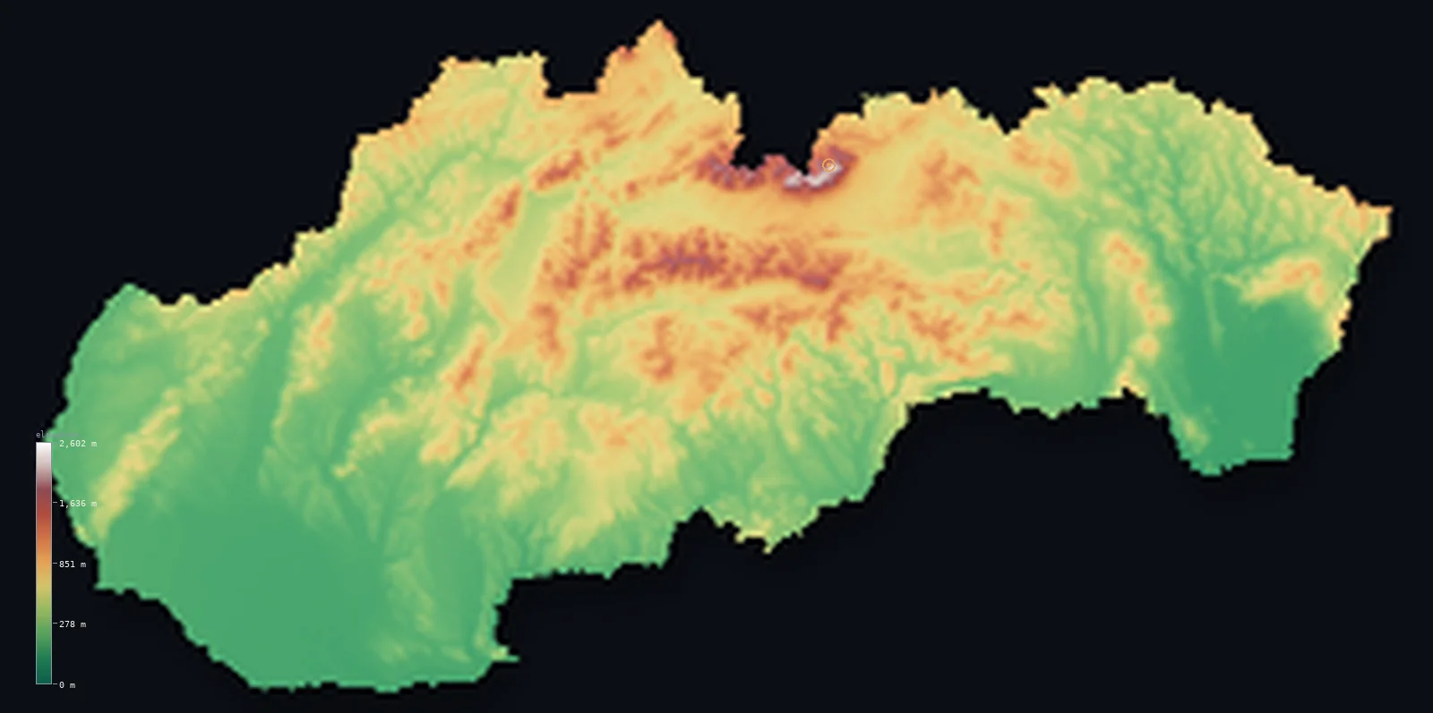
Slovakia’s highest point is Gerlachovsky stit at 8,711 ft (2,655 m); its lowest is Bodrog River at 308 ft (94 m); the mean elevation is 1,496 ft (456 m).
Slovakia climbs from a river to a wall of mountains. In the southwest it is lowland — the Danube plain around Bratislava, the country's warmest and lowest ground. But northward the land rises through range after range of the Carpathians, culminating in the High Tatras, a compact wall of sharp alpine peaks on the Polish border where Gerlachovský štít reaches 8,711 ft (2,655 m). Most of the country is mountain and hill; only the south is truly low.
- Highest point📚
- 8,711 ft2,655 m
- Slovakia's highest point is Gerlachovský štít at 8,711 ft (2,655 m), in the High Tatras on the Polish border — the highest peak of the whole Carpathian range, a sharp, rocky summit in a compact cluster of alpine mountains that rise abruptly from the surrounding country. The Tatras are small in extent but genuinely alpine.
- Lowest point📚
- 308 ft94 m
- Slovakia's lowest point is where the Bodrog river leaves the country in the southeast, at about 308 ft (94 m) — low, but well above sea level, as Slovakia is landlocked and drains south to the Danube and on toward the Black Sea.
- Mean elevation⚙
- 1,496 ft456 m
- Computed from the GLO-30 model, Slovakia's mean elevation is 1,496 ft (456 m) — high for central Europe, because the country is mostly mountain and hill: the Carpathian ranges fill the centre and north, and only the Danube lowland of the southwest and a strip of the southeast lie genuinely low.
- Median elevation⚙
- 1,273 ft388 m
- Half of Slovakia lies above 1,273 ft (388 m) — the midpoint sits this high because range upon range of the Carpathians fills the north and centre, leaving only the Danube lowland of the southwest genuinely low.
- Elevation range📚
- 8,402 ft2,561 m
- Slovakia's terrain climbs about 8,400 ft from the Bodrog to the summit of Gerlachovský štít — from the low southeastern river plain to the sharp alpine crest of the High Tatras, the country rising steadily northward through the Carpathian ranges to its highest wall.
- Above 1,000 m (3,281 ft)⚙
- 6%
- About 6% of Slovakia rises above 1,000 m (3,281 ft) — the higher Carpathian ranges, above all the High and Low Tatras of the north-centre. Much of the rest is hill country, with the genuinely low ground confined to the Danube plain of the southwest.
- Official area📚
- 18,933 mi²49,035 km²
- Slovakia covers about 18,900 sq mi (49,035 sq km) — a landlocked country in central Europe, filled by the Carpathian mountains across its centre and north, with the Danube plain along its southwestern edge around Bratislava.
- Forest cover📚
- 40.1%
- About 40.1% of Slovakia is forested — much of it on the Carpathian slopes, whose ranges carry extensive beech and spruce forest; the Danube lowland and the southern basins are more cultivated.
Highest and lowest points
Slovakia's highest point is Gerlachovský štít, 8,711 ft (2,655 m), in the High Tatras on the border with Poland — and it is the highest peak of the entire Carpathian range, which arcs through several countries but rises highest here. The High Tatras are a compact massif, small in extent but sharply alpine: glacially carved peaks, ridges, and lakes rising abruptly above the surrounding hills, more like a piece of the Alps than the rounded ranges around them. Gerlachovský štít stands entirely within Slovakia; nearby Rysy, on the crest, carries the Polish border, but Poland's own high point lies at a lower point on that peak.
source ↗Slovakia's lowest point is where the Bodrog river crosses out of the country into Hungary in the southeast, at about 308 ft (94 m) above sea level. Landlocked Slovakia drains southward: its rivers, gathered from the Carpathian ranges, run down to the Danube along the southern border and on toward the far-off Black Sea. Even this lowest ground sits well above the sea, in a country whose bulk is mountain and hill and whose low plains are only a southern fringe.
source ↗Slovakia at a glance
Gerlachovsky stit (2,655 m) is not only Slovakia's high point but the highest peak in the entire 1,200 km Carpathian range.
source ↗It is an interior summit - the higher border ridge nearby carries Rysy (2,499 m), which is Poland's highest point.
source ↗The peak was renamed repeatedly for political reasons - it was once Franz Joseph Peak and later Stalin Peak before its old name was restored.
source ↗The High Tatras are one of the few places in the whole Carpathian arc with a truly alpine, glacier-carved landscape.
source ↗From the 2,655 m Tatras the land falls to just 94 m on the Bodrog plain - a big range for a small country.
source ↗The Danube forms part of Slovakia's southern border and, around Bratislava, spreads into the lowland that is the country's warmest and lowest ground.
source ↗
Elevation profile of Slovakia
The largest share of land, 26%, falls in the 200–400 m band, and 62% of the territory lies below 500 m (1,640 ft).
- below 500 m (1,640 ft)62%
- 500–1,000 m33%
- 1,000–2,000 m6%
- above 2,000 m (6,562 ft)<1%
Highest peaks of Slovakia
| Peak | Elevation | Range | Note |
|---|---|---|---|
| Gerlachovsky stit↗ | 8,711 ft2,655 m | High Tatras | Highest point of Slovakia and of the whole Carpathian range. |
| Lomnicky stit↗ | 8,642 ft2,634 m | High Tatras | A famous High Tatras peak reached by cable car, the second-highest in the country. |
| Krivan↗ | 8,182 ft2,494 m | High Tatras | A striking peak of the High Tatras, a national symbol of Slovakia. |
| Dumbier↗ | 6,703 ft2,043 m | Low Tatras | The highest peak of the Low Tatras, the parallel range south of the Vah valley. |
| Velky Krivan↗ | 5,607 ft1,709 m | Mala Fatra | The high point of the Mala Fatra range in northwestern Slovakia. |
Slovakia south to north: plain, hills, and the Tatra wall
The High and Low Tatras and the northern mountains
Northern Slovakia holds the country's highest ground — the High Tatras on the Polish border, a compact wall of sharp alpine peaks with Gerlachovský štít, and the neighbouring Low Tatras and other ranges. Glacially carved, forested below and rocky above, they are the roof of the Carpathians.
The central Carpathian hills and basins
Through the centre of the country runs range after range of lower Carpathian mountains and hills, separated by basins and river valleys — the ore mountains, forested ridges, and the mining and spa towns set among them. Upland country, neither alpine nor lowland, covering much of Slovakia.
The Danube lowland and the south
Along the southwest, around Bratislava, and in a strip of the southeast lies Slovakia's low ground — the Danube plain, warm and fertile, the country's agricultural heartland and its lowest, flattest terrain. It is a southern fringe to an otherwise upland country.
How to read this map
Color shows elevation; the raised relief shows real terrain. On this map Slovakia rises from southwest to north — the low green Danube plain around Bratislava in the southwest, giving way to the browns of range after range of Carpathian hills and mountains across the centre, and the sharp white-and-brown wall of the High Tatras gathered on the northern border.
The 3D relief is the actual GLO-30 elevation data, exaggerated vertically so the alpine Tatras and the lowland plain both show; the ×N relief slider controls how much. Tap anywhere to read that point's exact elevation.
City elevations in Slovakia
Slovakia's cities sit mostly in the valleys and the southern lowland — Bratislava in the far southwest on the Danube, Košice in the eastern lowland, Prešov and Žilina in the northern valleys, Nitra and Banská Bystrica in the central basins. Few sit high; the mountains hold small towns, not large cities.
| City | Population | Elevation |
|---|---|---|
| Bratislavacapitalthe capital, in the far southwest on the Danube, at the edge of the plain near Austria and Hungary ↗ | 423,737 | 522 ft159 m |
| Košicein the eastern lowland, the country's second city ↗ | 225,044 | 686 ft209 m |
| Nitrain the western Danube lowland, below Zobor hill ↗ | 86,329 | 489 ft149 m |
| Prešovin a northeastern valley, near Košice ↗ | 82,927 | 817 ft249 m |
| Žilinain a northern valley among the Carpathian ranges ↗ | 81,219 | 1,148 ft350 m |
| Banská Bystricain a central mountain basin on the Hron ↗ | 74,590 | 1,220 ft372 m |
| Trnavain the western Danube lowland, near Bratislava ↗ | 62,806 | 492 ft150 m |
| Trenčínin the Váh valley of the northwest ↗ | 58,278 | 817 ft249 m |
| Popradin the north below the High Tatras, the highest of the major cities ↗ | 49,091 | 2,205 ft672 m |
| Prievidzain the upper Nitra basin of the centre-west ↗ | 43,645 | 948 ft289 m |
Elevation sampled at each city centre from the Copernicus GLO-30 model. Cities and population from GeoNames (CC-BY 4.0).
Slovakia in comparison
Slovakia's terrain rises 8,402 ft (2,561 m) from Bodrog River (308 ft (94 m)) to Gerlachovsky stit — about 29% of the height of Mount Everest, the world's highest point at 29,032 ft (8,849 m).
- Czechia's mean elevation is 1,486 ft — 10 ft lower; its high point, Sněžka, reaches 5,259 ft (1,603 m), 3,451 ft below. Czechia elevation map →
- Poland's mean elevation is 571 ft — 925 ft lower; its high point, Rysy, reaches 8,199 ft (2,499 m), 512 ft below. Poland elevation map →
- Austria's mean elevation is 3,127 ft — 1,631 ft higher; its high point, Grossglockner, reaches 12,461 ft (3,798 m), 3,750 ft above. Austria elevation map →
Frequently asked questions
What is the highest point in Slovakia?
- Gerlachovský štít, 8,711 ft (2,655 m), in the High Tatras on the Polish border — the highest peak of the entire Carpathian range.
What is the lowest point in Slovakia?
- Where the Bodrog river leaves the country in the southeast, at about 308 ft (94 m) — low, but well above sea level, as Slovakia is landlocked.
What is the average elevation of Slovakia?
- Computed from the Copernicus GLO-30 model, the area-weighted mean is 1,496 ft (456 m) — fairly high, because Slovakia is mostly mountain and hill, with low ground only in the Danube plain of the southwest.
How high are the Tatras?
- The High Tatras rise to Gerlachovský štít at 2,655 m, the highest point of the Carpathians — a compact but genuinely alpine massif of sharp peaks, ridges, and glacial lakes on the Polish border.
Is Slovakia mountainous?
- Mostly — range upon range of the Carpathians fills the north and centre, and about half the country lies above 388 m. The genuinely low ground is confined to the Danube plain of the southwest around Bratislava.
Is this a topographic, relief, contour, or elevation map of Slovakia?
- They describe the same thing — terrain height. This page renders the country's actual elevation surface in interactive 3D and reports the statistics computed from it.
About this map
The terrain is rendered from the Copernicus GLO-30 digital elevation model (ESA), masked to the SVK-ADM0 boundary from geoBoundaries (gbOpen). Elevation statistics are computed directly from the model; peak names and researched facts are sourced and cited. See the methodology for the full pipeline.
Our area-weighted mean, computed from the Copernicus GLO-30 model, is 1,496 ft (456 m); the figure commonly cited elsewhere is 1,503 ft (458 m) (CIA World Factbook). Slovakia arches over the Carpathians - high and mountainous across the north and centre, dropping to the Danubian lowland in the southwest and the Bodrog plain in the southeast - giving a moderate mean; the page reports the area-weighted figure computed from the Copernicus GLO-30 model.
Surveyed national figures: official area · forest cover · high point.
Rendered from Copernicus GLO-30 (ESA, 2021 release), boundaries from geoBoundaries. Generated 2026-06-26.
Bordering countries · 5
Slovakia shares a land border with these countries — open any one to compare its terrain and highest point.