Hungary Elevation Map — Topographic & 3D Terrain
Explore the terrain of Hungary in interactive 3D, built from Copernicus GLO-30 satellite elevation data — the flat heart of the Carpathian Basin, ringed by mountains beyond its borders. Drag to rotate, scroll to zoom, and tap any point to read its elevation.
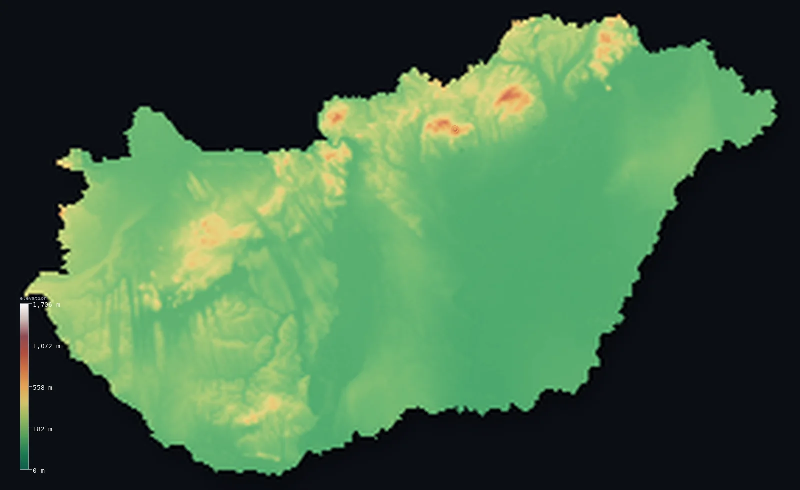
Hungary’s highest point is Kekes at 3,327 ft (1,014 m); its lowest is Tisza River near Szeged at 256 ft (78 m); the mean elevation is 492 ft (150 m).
Hungary is the floor of a basin. It occupies the flat centre of the Carpathian Basin — the Great Hungarian Plain spreading east of the Danube, the smaller Little Plain to the northwest — a broad, low expanse of farmland and river that makes it one of the flatter countries in Europe. The mountains that ring the basin lie mostly beyond Hungary's borders; within them, the land rises only in the low Mátra hills of the north, where Kékes, the highest point, reaches just 3,327 ft (1,014 m). The Danube crosses the country from north to south, and Lake Balaton, central Europe's largest lake, lies in the west.
- Highest point📚
- 3,327 ft1,014 m
- Hungary's highest point is Kékes at 3,327 ft (1,014 m), in the Mátra hills of the north — a modest, forested summit in the only part of the country with any real relief, the low volcanic ranges that fringe the northern edge of the Great Plain. In a country this flat, it is the closest thing to a mountain.
- Lowest point📚
- 256 ft78 m
- Hungary's lowest point is on the river Tisza in the south, at about 256 ft (78 m) — low, but still well above sea level, as befits a landlocked country on the floor of an inland basin. The Tisza winds across the Great Plain, the flattest and lowest of Hungary's ground.
- Mean elevation⚙
- 492 ft150 m
- Computed from the GLO-30 model, Hungary's mean elevation is 492 ft (150 m) — low, and a true measure of the country: Hungary is mostly the flat floor of the Carpathian Basin, plain and river valley, with only the low northern hills rising above it.
- Median elevation⚙
- 400 ft122 m
- Half of Hungary lies below 400 ft (122 m) — barely above the low point, which tells the whole story: this is a country of plains. The Great Hungarian Plain and the river valleys are so dominant that the typical point in Hungary is flat lowland, not hill.
- Elevation range📚
- 3,071 ft936 m
- From the Tisza to the summit of Kékes, Hungary spans only about 3,070 ft — a small range, and even that modest: Hungary has no high ground, only the low Mátra hills lifting slightly above an otherwise flat country on the basin floor.
- Above 1,000 m (3,281 ft)⚙
- <1%
- Under 1% of Hungary rises above 1,000 m (3,281 ft) — effectively just the summit of Kékes in the Mátra hills. Even the 656 ft (200 m) line is crossed by only about 18% of the country, the low ranges along the northern border and a few scattered uplands; the rest is plain — little in Europe is flatter.
- Official area📚
- 35,918 mi²93,028 km²
- Hungary covers about 35,900 sq mi (93,028 sq km) — a landlocked country occupying the flat centre of the Carpathian Basin, ringed (beyond its borders) by the Carpathians and the Alps, and crossed by the Danube and the Tisza.
- Forest cover📚
- 22.5%
- About 22.5% of Hungary is forested — a modest share, most of it on the northern hills and scattered across the plains; the Great Plain itself is overwhelmingly farmland, one of the most cultivated landscapes in Europe.
Highest and lowest points
Hungary's highest point is Kékes, 3,327 ft (1,014 m), in the Mátra hills of northern Hungary — a forested, rounded summit that just clears 1,000 m, carrying a viewing tower and the country's small ski runs. The Mátra are a low volcanic range along the northern edge of the Great Plain, part of the only belt of real relief in the country. Hungary lies on the flat floor of the Carpathian Basin, and its true mountains — the Carpathians and the Alps that ring the basin — lie beyond its borders; Kékes is the highest the land rises within them.
source ↗Hungary's lowest point is on the river Tisza in the far south, at about 256 ft (78 m) above sea level — low, but not near the sea, since Hungary is landlocked and sits on the floor of the inland Carpathian Basin. The Tisza is the great river of the Hungarian plain, winding slowly across the flat, open Alföld before crossing into Serbia toward the Danube. In a country of so little relief, the difference between its lowest and highest ground is under a thousand metres.
source ↗Hungary at a glance
Hungary occupies the flat centre of the Carpathian Basin — the Great Hungarian Plain — its highest point, Kékes, reaching just 1,014 m.
source ↗The mountains that ring the Carpathian Basin lie mostly beyond Hungary's borders — within the country the land rises only in low hills like the Mátra.
source ↗Lake Balaton in western Hungary is the largest lake in Central Europe — a shallow, warm lake on the plain that Hungarians call the 'Hungarian Sea.'
source ↗The Danube crosses Hungary from north to south, dividing the hillier Transdanubia in the west from the Great Plain in the east, and passing through Budapest.
source ↗The Great Hungarian Plain — the Alföld — covers much of the country east of the Danube: a vast flat expanse of farmland, river, and the grassland puszta.
source ↗The Mátra range that holds Kékes is part of one of Europe's largest belts of young volcanic rock.
source ↗Hungary's thermal springs are among the richest in Europe, fed by the geology beneath the basin, and feed the famous baths of Budapest.
source ↗
Elevation profile of Hungary
The largest share of land, 52%, falls in the 100–200 m band, and 99% of the territory lies below 500 m (1,640 ft).
- below 500 m (1,640 ft)99%
- 500–1,000 m1%
- 1,000–2,000 m<1%
Highest peaks of Hungary
| Peak | Elevation | Range | Note |
|---|---|---|---|
| Kekes↗ | 3,327 ft1,014 m | Matra (North Hungarian Mountains) | Highest point of Hungary, in the Matra range northeast of Budapest. |
| Galyateto↗ | 3,166 ft965 m | Matra (North Hungarian Mountains) | The second-highest summit in Hungary, also in the Matra range. |
| Irott-ko↗ | 2,894 ft882 m | Alpokalja (Austria border) | The high point of the Alpokalja - the easternmost foothills of the Alps - on the Austrian border in the west. |
| Pilis↗ | 2,484 ft757 m | Transdanubian Mountains | The high point of the Transdanubian Mountains, near the Danube Bend northwest of Budapest. |
| Zengo↗ | 2,238 ft682 m | Mecsek (south) | The high point of the Mecsek, the southernmost Hungarian range, north of Pecs. |
The plain, the west, and the northern hills
The Great Hungarian Plain (Alföld)
East and south of the Danube spreads the Great Hungarian Plain — the Alföld — a vast, flat expanse of farmland, slow rivers, and the grassland puszta, covering more than half the country. It is the flattest and lowest of Hungary's ground, the floor of the Carpathian Basin, and the reason the country's elevation figures are so low.
Transdanubia and the west
West of the Danube lies Transdanubia — gentler, hillier country of low ranges, the Bakony and Mecsek hills, and Lake Balaton, central Europe's largest lake. Rolling rather than flat, it is higher than the Great Plain but still far from mountainous, and holds the Little Plain in its northwest.
The northern hills
Along the northern border runs Hungary's only belt of real relief — a line of low volcanic and limestone ranges including the Mátra, holding Kékes, the country's high point, and the Bükk. Forested and modest, they fringe the edge of the Great Plain and are the highest ground in the country.
How to read this map
Color shows elevation; the raised relief shows real terrain. On this map Hungary reads almost entirely in low greens — the flat Great Plain filling the east and south, the gently hillier Transdanubia west of the Danube — with a thin band of raised brown along the northern border, the low hills that hold Kékes.
The 3D relief is the actual GLO-30 elevation data, exaggerated vertically so that a country this flat shows any shape at all; the ×N relief slider controls how much. Tap anywhere to read that point's exact elevation.
City elevations in Hungary
Hungarian cities sit on the plains and the river — Budapest on the Danube in the north-centre, Debrecen and Szeged out on the Great Plain, Győr on the Little Plain, Pécs in the southern hills of Transdanubia. Nearly all sit low, on flat or gently rolling ground.
| City | Population | Elevation |
|---|---|---|
| Budapestcapitalthe capital, on the Danube where the hills of Buda meet the plain of Pest ↗ | 1,741,041 | 381 ft116 m |
| Debrecenon the Great Plain in the east, the country's second city ↗ | 202,402 | 410 ft125 m |
| Szegedon the Tisza in the south, near the Serbian border ↗ | 160,766 | 289 ft88 m |
| Miskolcin the north, at the foot of the Bükk hills ↗ | 154,521 | 440 ft134 m |
| Pécsin the southern hills of Transdanubia, below the Mecsek ↗ | 145,347 | 515 ft157 m |
| Győron the Little Plain in the northwest, between Budapest and Vienna ↗ | 129,301 | 384 ft117 m |
| Nyíregyházaon the Great Plain in the northeast ↗ | 117,689 | 377 ft115 m |
| Kecskemétin the centre of the Great Plain, between the Danube and the Tisza ↗ | 109,847 | 397 ft121 m |
| Székesfehérvárin Transdanubia, near the Bakony hills ↗ | 101,600 | 377 ft115 m |
| Szombathelyin the far west, near the Austrian border ↗ | 78,025 | 712 ft217 m |
Elevation sampled at each city centre from the Copernicus GLO-30 model. Cities and population from GeoNames (CC-BY 4.0).
Hungary in comparison
Hungary's terrain rises 3,071 ft (936 m) from Tisza River near Szeged (256 ft (78 m)) to Kekes — about 11% of the height of Mount Everest, the world's highest point at 29,032 ft (8,849 m).
- Austria's mean elevation is 3,127 ft — 2,635 ft higher; its high point, Grossglockner, reaches 12,461 ft (3,798 m), 9,134 ft above. Austria elevation map →
- Slovakia's mean elevation is 1,496 ft — 1,004 ft higher; its high point, Gerlachovsky stit, reaches 8,711 ft (2,655 m), 5,384 ft above. Slovakia elevation map →
- Romania's mean elevation is 1,312 ft — 820 ft higher; its high point, Moldoveanu, reaches 8,346 ft (2,544 m), 5,020 ft above. Romania elevation map →
Frequently asked questions
What is the highest point in Hungary?
- Kékes, 3,327 ft (1,014 m), in the Mátra hills of the north — a modest forested summit, the highest the land rises in a country that is mostly flat plain.
What is the lowest point in Hungary?
- The river Tisza in the south, at about 256 ft (78 m) — low, though well above sea level, since Hungary is landlocked on the basin floor.
What is the average elevation of Hungary?
- Computed from the Copernicus GLO-30 model, the area-weighted mean is 492 ft (150 m) — low, because Hungary is mostly the flat floor of the Carpathian Basin, with only the low northern hills rising above it.
Is Hungary flat?
- Largely — it occupies the flat centre of the Carpathian Basin, with only about 18% above 200 m and a highest point of just 1,014 m. The Great Hungarian Plain covers more than half the country.
What is the Great Hungarian Plain?
- The Alföld — the vast flat lowland east and south of the Danube, covering more than half of Hungary: farmland, slow rivers, and the grassland puszta, the floor of the Carpathian Basin.
Is this a topographic, relief, contour, or elevation map of Hungary?
- They describe the same thing — terrain height. This page renders the country's actual elevation surface in interactive 3D and reports the statistics computed from it.
About this map
The terrain is rendered from the Copernicus GLO-30 digital elevation model (ESA), masked to the HUN-ADM0 boundary from geoBoundaries (gbOpen). Elevation statistics are computed directly from the model; peak names and researched facts are sourced and cited. See the methodology for the full pipeline.
Our area-weighted mean, computed from the Copernicus GLO-30 model, is 492 ft (150 m); the figure commonly cited elsewhere is 469 ft (143 m) (CIA World Factbook). Hungary sits in the low Carpathian Basin - about 84% of the country lies below 200 m, dominated by the Great Hungarian Plain, with hills and low mountains only in the west and north - so the mean elevation is low; the page reports the area-weighted figure computed from the Copernicus GLO-30 model.
Surveyed national figures: official area · forest cover · high point.
Rendered from Copernicus GLO-30 (ESA, 2021 release), boundaries from geoBoundaries. Generated 2026-06-23.
Bordering countries · 7
Hungary shares a land border with these countries — open any one to compare its terrain and highest point.