Croatia Elevation Map — Topographic & 3D Terrain
Explore the terrain of Croatia in interactive 3D, built from Copernicus GLO-30 satellite elevation data — a crescent wrapping from the Pannonian plain to the Adriatic coast and its karst mountains. Drag to rotate, scroll to zoom, and tap any point to read its elevation.
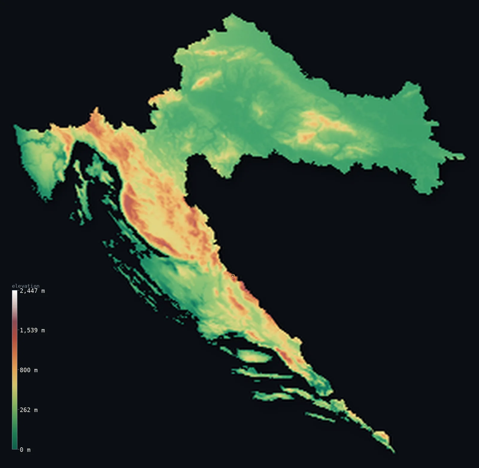
Croatia’s highest point is Dinara (Sinjal) at 6,007 ft (1,831 m); its lowest is Adriatic Sea at 0 ft (0 m); the mean elevation is 1,027 ft (313 m).
Croatia is shaped like a crescent, and it changes completely along its length. The northern arm is lowland — the Pannonian plain around Zagreb and the Sava valley, flat and fertile. But the arm that curves south down the Adriatic is mountainous: the Dinaric Alps rise as a wall of grey karst just behind a long, island-fringed coast, climbing to Dinara at 6,007 ft (1,831 m) on the Bosnian border. Between the two lies a country of two utterly different halves.
- Highest point📚
- 6,007 ft1,831 m
- Croatia's highest point is Dinara at 6,007 ft (1,831 m), on the border with Bosnia and Herzegovina — the peak that gives the whole Dinaric Alps their name, a bare, grey mass of karst limestone rising behind the Dalmatian coast. It is the high point of the mountain wall that separates Croatia's coast from its interior.
- Lowest point📚
- 0 ft0 m
- Croatia's lowest point is the Adriatic Sea at sea level, along a coast of remarkable length — deeply indented and fringed by over a thousand islands, one of the most broken and intricate coastlines in the Mediterranean.
- Mean elevation⚙
- 1,027 ft313 m
- Computed from the GLO-30 model, Croatia's mean elevation is 1,027 ft (313 m) — a moderate figure that averages the country's split halves: the low Pannonian plain of the north and the karst mountains that rise behind the Adriatic coast.
- Median elevation⚙
- 623 ft190 m
- Half of Croatia lies below 623 ft (190 m) — and the number hides the country's division: Croatia is not uniformly middling but sharply two-part, a low northern plain and a mountainous coastal belt, and the median sits between two landscapes rather than describing either.
- Elevation range📚
- 6,007 ft1,831 m
- Croatia's relief spans about 6,010 ft — but the figure hides the crescent's shape: flat and low across the Pannonian north, then rising up the Dinaric karst wall behind the coast to Dinara on the Bosnian border.
- Above 1,000 m (3,281 ft)⚙
- 4%
- About 4% of Croatia rises above 1,000 m (3,281 ft) — the Dinaric ranges behind the Adriatic coast and the highland of Gorski Kotar and Lika. The northern Pannonian lowland around Zagreb lies far below.
- Official area📚
- 21,851 mi²56,594 km²
- Croatia covers about 21,900 sq mi (56,594 sq km) — a crescent-shaped country curving from the Pannonian plain in the north down the Adriatic coast, with a long, island-studded shoreline and the Dinaric mountains behind it.
- Forest cover📚
- 46.8%
- About 46.8% of Croatia is forested — extensively, especially in the mountainous Gorski Kotar and Lika highlands behind the coast, whose karst slopes carry beech and fir; the plains are more cultivated and the outer islands rockier and barer.
Highest and lowest points
Croatia's highest point is Dinara, 6,007 ft (1,831 m), on the border with Bosnia and Herzegovina — the mountain that lends its name to the entire Dinaric Alps, the great karst range running down the eastern Adriatic. It is a bare, grey wall of limestone, rising steeply behind the Dalmatian coast, its slopes riddled with the sinkholes, caves, and dry valleys typical of karst country. It stands at the inland edge of a country whose mountains and coast are pressed close together, the sea only a short distance from the peaks.
source ↗Croatia's lowest point is the Adriatic at sea level — and few countries are so defined by their coast. Croatia's Adriatic shoreline is one of the longest and most intricate in the Mediterranean, deeply indented and fringed by more than a thousand islands, islets, and rocks, of which only a few dozen are inhabited. The karst of the Dinaric mountains reaches right to the sea here, so the coast is steep and rocky, its islands the drowned ridges of the same limestone ranges that rise behind the shore.
source ↗Croatia at a glance
Croatia is crescent-shaped, curving from the Pannonian plain in the north down the length of the Adriatic coast — a country of two very different halves.
source ↗Dinara (1,831 m), Croatia's highest point, gives its name to the entire Dinaric Alps — a mountain system stretching some 645 km from Italy and Slovenia to Albania.
source ↗Croatia has 1,246 islands and islets — among the most island-rich coasts in the Mediterranean — adding over 4,000 km of shoreline to the 1,777 km mainland coast.
source ↗About half of Croatia is karst — soluble limestone landscape — giving the country roughly 7,000 caves and pits, including three more than 1,000 m deep.
source ↗The karst even shapes Croatia's most famous scenery — the 16 turquoise Plitvice Lakes are dammed by natural travertine barriers of dissolved and redeposited limestone.
source ↗Northern Croatia, around Zagreb and the Sava valley, is part of the flat Pannonian plain — a different world from the mountainous Adriatic south.
source ↗
Elevation profile of Croatia
The largest share of land, 52%, falls in the 0–200 m band, and 79% of the territory lies below 500 m (1,640 ft).
- below 500 m (1,640 ft)79%
- 500–1,000 m17%
- 1,000–2,000 m4%
Highest peaks of Croatia
| Peak | Elevation | Range | Note |
|---|---|---|---|
| Dinara (Sinjal)↗ | 6,007 ft1,831 m | Dinaric Alps (Dinara) | Highest point of Croatia, on the Bosnia border; eponym of the Dinaric Alps. |
| Sveti Jure (Biokovo)↗ | 5,781 ft1,762 m | Biokovo (Dinaric Alps) | The summit of the Biokovo massif, rising almost straight from the Adriatic above the Makarska Riviera. |
| Vaganski vrh (Velebit)↗ | 5,764 ft1,757 m | Velebit (Dinaric Alps) | The highest point of Velebit, Croatia's longest mountain range, paralleling the northern Adriatic coast. |
| Ozeblin (Plješivica)↗ | 5,436 ft1,657 m | Plješivica (Dinaric Alps) | The high point of the Plješivica range in the Lika region along the Bosnian border. |
| Veliki Risnjak↗ | 5,013 ft1,528 m | Risnjak (Gorski Kotar, Dinaric Alps) | The peak of Risnjak in the forested Gorski Kotar highlands, within Risnjak National Park. |
The crescent's two halves — plain and coast
The Pannonian north
The northern arm of the country — the lowland around Zagreb, the Sava and Drava valleys, and the plains of Slavonia to the east — is part of the great Pannonian basin. Flat to gently rolling, fertile and farmed, it is Croatia's low ground and holds the capital and much of the population.
The Dinaric mountains and highlands
Behind the coast rise the Dinaric Alps — a belt of grey karst mountains and forested highland (Gorski Kotar, Lika) climbing to Dinara on the Bosnian border. Limestone country of caves, sinkholes, and vanishing rivers, it is the mountainous spine dividing the coast from the interior.
The Adriatic coast and islands
The long southern arm of Croatia is Adriatic coast — a narrow, steep, rocky shore where the karst meets the sea, fringed by more than a thousand islands. From Istria in the north down the Dalmatian coast to Dubrovnik, it is one of the most intricate and island-studded coastlines in the Mediterranean.
How to read this map
Color shows elevation; the raised relief shows real terrain. On this map Croatia's crescent shows two countries at once — the low green Pannonian plain filling the northern arm around Zagreb, and the brown karst mountains of the Dinaric Alps running down the coastal arm behind a shore scattered with islands.
The 3D relief is the actual GLO-30 elevation data, exaggerated vertically so the coastal mountains and the northern plain both show; the ×N relief slider controls how much. Tap anywhere to read that point's exact elevation.
City elevations in Croatia
Croatia's cities split between its halves — Zagreb inland on the northern Pannonian plain, and the coastal cities strung down the Adriatic: Split and Zadar on the Dalmatian coast, Rijeka at the head of the Kvarner gulf, Osijek out on the eastern Slavonian plain. Most sit low, on plain or coast.
| City | Population | Elevation |
|---|---|---|
| Zagrebcapitalthe capital, inland on the Pannonian plain in the north, on the Sava ↗ | 663,592 | 446 ft136 m |
| Spliton the Dalmatian coast beneath the Dinaric mountains ↗ | 149,830 | 46 ft14 m |
| Rijekaat the head of the Kvarner gulf, the country's main port ↗ | 107,964 | 43 ft13 m |
| Osijekon the Drava in the eastern Slavonian plain ↗ | 75,535 | 302 ft92 m |
| Zadaron the Dalmatian coast in the north, among its islands ↗ | 67,309 | 36 ft11 m |
| Pulaat the tip of the Istrian peninsula in the northwest ↗ | 52,220 | 43 ft13 m |
| Slavonski Brodon the Sava in the east, on the Bosnian border ↗ | 45,005 | 305 ft93 m |
| Karlovacinland southwest of Zagreb, where the lowland meets the highland ↗ | 41,869 | 377 ft115 m |
| Brčko | 38,968 | 318 ft97 m |
| Varaždinin the far north, on the Drava near the Slovenian border ↗ | 36,187 | 571 ft174 m |
Elevation sampled at each city centre from the Copernicus GLO-30 model. Cities and population from GeoNames (CC-BY 4.0).
Croatia in comparison
Croatia's terrain rises 6,007 ft (1,831 m) from sea level to Dinara (Sinjal) — about 21% of the height of Mount Everest, the world's highest point at 29,032 ft (8,849 m).
- Bosnia and Herzegovina's mean elevation is 2,267 ft — 1,240 ft higher; its high point, Maglić, reaches 7,828 ft (2,386 m), 1,821 ft above. Bosnia and Herzegovina elevation map →
- Slovenia's mean elevation is 1,860 ft — 833 ft higher; its high point, Triglav, reaches 9,396 ft (2,864 m), 3,389 ft above. Slovenia elevation map →
- Montenegro's mean elevation is 3,386 ft — 2,359 ft higher; its high point, Zla Kolata, reaches 8,314 ft (2,534 m), 2,306 ft above. Montenegro elevation map →
Frequently asked questions
What is the highest point in Croatia?
- Dinara, 6,007 ft (1,831 m), on the Bosnian border — the peak that names the whole Dinaric Alps, a karst wall behind the Dalmatian coast.
What is the lowest point in Croatia?
- The Adriatic Sea at sea level, along one of the most indented, island-fringed coastlines in the Mediterranean.
What is the average elevation of Croatia?
- Computed from the Copernicus GLO-30 model, the area-weighted mean is 1,027 ft (313 m) — moderate, averaging the low Pannonian plain of the north and the karst mountains behind the Adriatic coast.
Why is Croatia shaped like a crescent?
- It curves from the Pannonian plain in the north down the length of the Adriatic coast, wrapping around Bosnia — two very different halves, a low northern plain and a mountainous, island-fringed coast.
How many islands does Croatia have?
- 1,246 islands, islets, and rocks along the Adriatic, of which only a few dozen are inhabited — the drowned ridges of the Dinaric limestone, among the most island-rich coasts in the Mediterranean.
Is this a topographic, relief, contour, or elevation map of Croatia?
- They describe the same thing — terrain height. This page renders the country's actual elevation surface in interactive 3D and reports the statistics computed from it.
About this map
The terrain is rendered from the Copernicus GLO-30 digital elevation model (ESA), masked to the HRV-ADM0 boundary from geoBoundaries (gbOpen). Elevation statistics are computed directly from the model; peak names and researched facts are sourced and cited. See the methodology for the full pipeline.
Our area-weighted mean, computed from the Copernicus GLO-30 model, is 1,027 ft (313 m); the figure commonly cited elsewhere is 1,086 ft (331 m) (CIA World Factbook). Over half of Croatia is lowland below 200 m — the Pannonian plains of the northeast — while the rugged Dinaric karst rises in the interior and along the coast, so the mean elevation is moderate; the page reports the area-weighted figure computed from the Copernicus GLO-30 model.
Surveyed national figures: official area · forest cover · high point.
Rendered from Copernicus GLO-30 (ESA, 2021 release), boundaries from geoBoundaries. Generated 2026-06-22.
Bordering countries · 5
Croatia shares a land border with these countries — open any one to compare its terrain and highest point.