Montenegro Elevation Map — Topographic & 3D Terrain
Explore the terrain of Montenegro in interactive 3D, built from Copernicus GLO-30 satellite elevation data — a small country of extreme relief, from the Adriatic to high mountains in a few miles. Drag to rotate, scroll to zoom, and tap any point to read its elevation.
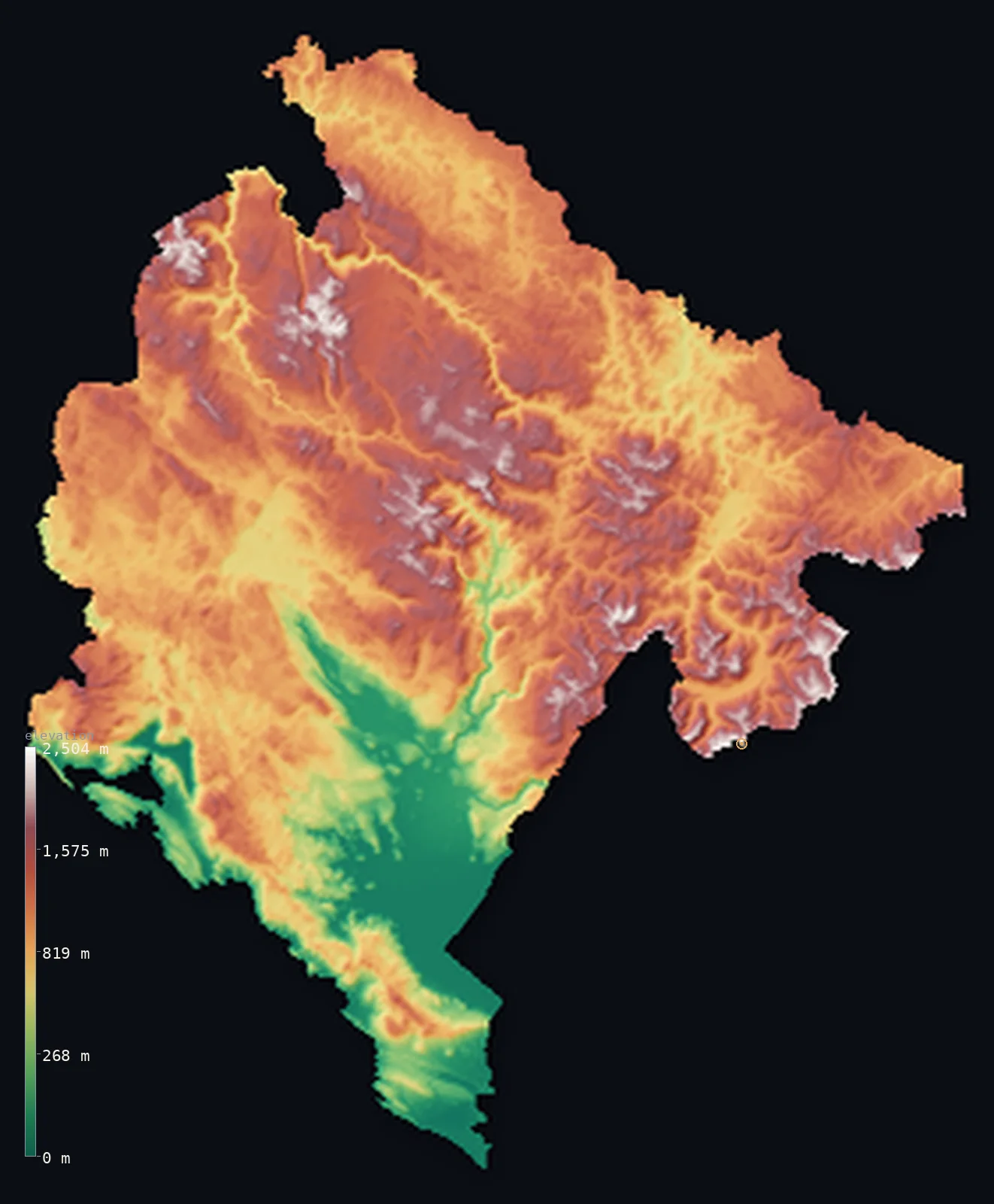
Montenegro’s highest point is Zla Kolata at 8,314 ft (2,534 m); its lowest is Adriatic Sea at 0 ft (0 m); the mean elevation is 3,386 ft (1,032 m).
Montenegro packs enormous relief into a small space. In a country of barely 5,300 square miles, the land climbs from the Adriatic Sea to mountains above 8,000 ft, often within a few miles of the coast — the name means 'black mountain,' and the country is overwhelmingly mountainous. More than half of it stands above 3,281 ft (1,000 m); its median elevation is actually higher than its mean. The high point is Zla Kolata, 8,314 ft (2,534 m), in the Accursed Mountains on the Albanian border, while the iconic Durmitor massif rises inland to nearly the same height.
- Highest point📚
- 8,314 ft2,534 m
- Montenegro's highest point is Zla Kolata at 8,314 ft (2,534 m), in the Accursed Mountains — the Prokletije — on the Albanian border in the east. It marginally tops the more famous Bobotov Kuk (2,523 m) in the Durmitor massif, the mountain most associated with Montenegro. Both stand in a country whose terrain is high and steep almost throughout.
- Lowest point📚
- 0 ft0 m
- Montenegro's lowest point is the Adriatic Sea at sea level, along a short, dramatic coast where the mountains rise almost straight from the water — including the Bay of Kotor, a deep, fjord-like inlet ringed by steep slopes.
- Mean elevation⚙
- 3,386 ft1,032 m
- Computed from the GLO-30 model, Montenegro's mean elevation is 3,386 ft (1,032 m) — a figure that ranks it among Europe's most mountainous countries: the land climbs almost everywhere, from the karst behind the coast to the high interior massifs, leaving only narrow strips of low ground.
- Median elevation⚙
- 3,527 ft1,075 m
- Half of Montenegro lies above 3,527 ft (1,075 m) — a median higher than the mean, which is unusual and revealing: it means the bulk of the country is genuinely high, the mountains so dominant that more than half the land sits above 1,000 m, with the low coast and valleys the exceptions that pull the average down.
- Elevation range📚
- 8,314 ft2,534 m
- Montenegro's relief runs about 8,310 ft from end to end — extraordinary for its size: the Adriatic and the 2,534 m summit of Zla Kolata sit only a short distance apart, giving the country the steepest rise-per-mile of almost any in the region.
- Above 1,000 m (3,281 ft)⚙
- 57%
- 57% of Montenegro rises above 1,000 m (3,281 ft) — the karst highlands behind the coast, the Durmitor and Bjelasica massifs of the interior, and the Prokletije on the Albanian border. Only the coast and the river valleys lie low.
- Above 2,000 m (6,562 ft)⚙
- 1%
- Roughly 1% of Montenegro stands above 2,000 m (6,562 ft) — the highest massifs, Durmitor around Bobotov Kuk and the Prokletije around Zla Kolata, the country's alpine crest.
- Official area📚
- 5,333 mi²13,812 km²
- Montenegro covers only about 5,300 sq mi (13,812 sq km) — a small country on the Adriatic, overwhelmingly mountainous, rising from a short dramatic coast to high massifs in the interior over a very short distance.
- Forest cover📚
- 61.5%
- About 61.5% of Montenegro is forested — extensively, well over half the country, with dense forest on the mountain slopes of the interior and the karst highlands; Montenegro has some of the last old-growth forest in Europe, in Biogradska Gora.
Highest and lowest points
Montenegro's highest point is Zla Kolata, 8,314 ft (2,534 m), in the Accursed Mountains — the Prokletije — on the border with Albania in the far east. It edges out, by about 11 m, the far more famous Bobotov Kuk (2,523 m) in the Durmitor massif, which is the mountain most people picture as Montenegro's — a dramatic limestone range of peaks, canyons, and glacial lakes, and a national park. Zla Kolata is the higher summit; Durmitor is the iconic one. Both belong to a country whose terrain is remarkable for its steepness: nowhere else in the region does the land rise so far, so fast, from sea to summit in so small a space.
source ↗Montenegro's lowest point is the Adriatic at sea level, along a short but spectacular coast where the mountains meet the sea almost without a lowland between them. Its centrepiece is the Bay of Kotor — a deep, winding inlet often called Europe's southernmost fjord (though it is a drowned river canyon, not a glacial one), ringed by slopes rising steeply to over 1,000 m directly from the shore. From this coast the land climbs abruptly inland: within a few miles the karst rears up, and the country becomes mountain almost at once.
source ↗Zla Kolata is a border summit: its peak lies just outside the generalized Montenegro boundary, so the highest fully in-territory land pixel in the model is 8,189 ft (2,496 m). The headline figure above is the surveyed elevation of the recognised national high point.
Montenegro at a glance
Montenegro's true highest point, Zla Kolata (2,534 m), sits on the Albanian border; the more famous Bobotov Kuk (2,523 m) is only the highest peak lying entirely inside the country.
source ↗The Tara River Canyon in Durmitor is about 1,300 m deep - one of the deepest river canyons in the world and the deepest in Europe.
source ↗The Bay of Kotor is a deep, winding submerged river canyon often likened to a fjord, ringed by mountains rising straight from the sea.
source ↗Lake Skadar, on the border with Albania, is the largest lake in the Balkans, and much of its bed lies below sea level even though its surface is just above it.
source ↗The Prokletije, or 'Accursed Mountains', are among the wildest and least-explored ranges in Europe.
source ↗Mount Lovcen rises to over 1,700 m directly above the coast, so steeply that the climb from sea level to summit takes only a few kilometres.
source ↗
Elevation profile of Montenegro
The largest share of land, 18%, falls in the 1,000–1,200 m band, and 84% of the territory lies above 500 m (1,640 ft).
- below 500 m (1,640 ft)16%
- 500–1,000 m27%
- 1,000–2,000 m56%
- above 2,000 m (6,562 ft)1%
Highest peaks of Montenegro
| Peak | Elevation | Range | Note |
|---|---|---|---|
| Zla Kolata↗ | 8,314 ft2,534 m | Prokletije (east, Albanian border) | Highest point of Montenegro, a border summit in the Accursed Mountains. |
| Dobra Kolata↗ | 8,294 ft2,528 m | Prokletije (east) | The twin peak just northwest of Zla Kolata, the country's second-highest. |
| Bobotov Kuk↗ | 8,278 ft2,523 m | Durmitor (north) | The highest peak lying wholly within Montenegro, long regarded as the national high point. |
| Stirovnik (Lovcen)↗ | 5,738 ft1,749 m | Lovcen (southwest, above the coast) | The highest peak of Mount Lovcen, rising steeply above the Bay of Kotor and the Adriatic. |
Montenegro: coast, karst, and high massifs
The coast and the karst behind it
Montenegro's short Adriatic coast, including the fjord-like Bay of Kotor, gives way almost immediately to a steep wall of karst — bare limestone highlands rising abruptly from the sea. In a few miles the land climbs from beach to over 1,000 m, the coast and its mountain backdrop pressed hard together.
The high massifs of the interior
Inland rise Montenegro's great mountains — the Durmitor massif with Bobotov Kuk, cut by the deep Tara Canyon, the Bjelasica with its primeval forest, and the ranges around them. High, forested, and dramatic, dotted with glacial lakes, they are the mountainous core of the country.
The Prokletije and the eastern border
Along the eastern border with Albania rise the Accursed Mountains — the Prokletije — the highest and most rugged range in the country, holding Zla Kolata, the high point. Steep grey peaks and glacial cirques mark the wildest corner of Montenegro.
How to read this map
Color shows elevation; the raised relief shows real terrain. On this map Montenegro reads as almost all mountain — a narrow strip of low coast in the southwest (with the deep notch of the Bay of Kotor) giving way almost at once to browns and whites, the karst highlands and the high massifs of Durmitor and the Prokletije filling nearly the whole country.
The 3D relief is the actual GLO-30 elevation data, exaggerated vertically so the coast and the high interior both show — though here the terrain barely needs it; the ×N relief slider controls how much. Tap anywhere to read that point's exact elevation.
City elevations in Montenegro
Montenegro's towns sit mostly low, on the coast and in the interior valleys and basins — Podgorica, the capital, in the low Zeta plain of the south, Nikšić in a karst basin to the west, and coastal towns like Budva, Bar, and Herceg Novi strung along the Adriatic. The mountains hold few large settlements, though Rožaje sits high in the east.
| City | Population | Elevation |
|---|---|---|
| Podgoricacapitalthe capital, in the low Zeta plain of the south ↗ | 236,852 | 161 ft49 m |
| Nikšićin a karst basin in the west ↗ | 58,212 | 2,073 ft632 m |
| Herceg Noviat the mouth of the Bay of Kotor on the coast ↗ | 19,536 | 256 ft78 m |
| Pljevljain the northern mountains, near the Bosnian and Serbian borders ↗ | 19,489 | 2,536 ft773 m |
| Budvaon the Adriatic coast, below the coastal mountains ↗ | 18,000 | 26 ft8 m |
| Baron the southern Adriatic coast ↗ | 17,727 | 13 ft4 m |
| Bijelo Poljein the northeast, in the Lim valley ↗ | 15,400 | 2,005 ft611 m |
| Beranein the northeast, in the Lim valley toward the Prokletije ↗ | 11,073 | 2,215 ft675 m |
| Ulcinjon the far southern coast, near the Albanian border ↗ | 10,828 | 39 ft12 m |
| Rožajehigh in the eastern mountains near the Prokletije, the highest of the towns ↗ | 9,121 | 3,563 ft1,086 m |
Elevation sampled at each city centre from the Copernicus GLO-30 model. Cities and population from GeoNames (CC-BY 4.0).
Montenegro in comparison
Montenegro's terrain rises 8,314 ft (2,534 m) from sea level to Zla Kolata — about 29% of the height of Mount Everest, the world's highest point at 29,032 ft (8,849 m).
- Albania's mean elevation is 2,254 ft — 1,132 ft lower; its high point, Mount Korab, reaches 9,068 ft (2,764 m), 755 ft above. Albania elevation map →
- Bosnia and Herzegovina's mean elevation is 2,267 ft — 1,119 ft lower; its high point, Maglić, reaches 7,828 ft (2,386 m), 486 ft below. Bosnia and Herzegovina elevation map →
- Serbia's mean elevation is 1,352 ft — 2,034 ft lower; its high point, Midzor, reaches 7,116 ft (2,169 m), 1,198 ft below. Serbia elevation map →
Frequently asked questions
What is the highest point in Montenegro?
- Zla Kolata, 8,314 ft (2,534 m), in the Prokletije on the Albanian border — marginally higher than the famous Bobotov Kuk (2,523 m) in the Durmitor massif.
What is the lowest point in Montenegro?
- The Adriatic Sea at sea level, along a short, steep coast that includes the fjord-like Bay of Kotor.
What is the average elevation of Montenegro?
- Computed from the Copernicus GLO-30 model, the area-weighted mean is 3,386 ft (1,032 m) — high, because Montenegro is overwhelmingly mountainous; its median is even higher than its mean, so more than half the country lies above 1,000 m.
Why is Montenegro's median higher than its mean?
- Because the country is so thoroughly mountainous — more than half of it stands above 1,000 m, so the typical point is high, while the low coast and valleys pull the mean down below the median.
What is the Bay of Kotor?
- A deep, winding inlet on Montenegro's coast, ringed by steep mountains and often called Europe's southernmost fjord — though it is a drowned river canyon rather than a glacial fjord.
Is this a topographic, relief, contour, or elevation map of Montenegro?
- They describe the same thing — terrain height. This page renders the country's actual elevation surface in interactive 3D and reports the statistics computed from it.
About this map
The terrain is rendered from the Copernicus GLO-30 digital elevation model (ESA), masked to the MNE-ADM0 boundary from geoBoundaries (gbOpen). Elevation statistics are computed directly from the model; peak names and researched facts are sourced and cited. See the methodology for the full pipeline.
Our area-weighted mean, computed from the Copernicus GLO-30 model, is 3,386 ft (1,032 m); the figure commonly cited elsewhere is 3,563 ft (1,086 m) (CIA World Factbook). Montenegro is overwhelmingly mountainous - a narrow Adriatic coast backed by high Dinaric karst plateaus and the Prokletije, with peaks above 2,500 m - so its mean elevation is high; the page reports the area-weighted figure computed from the Copernicus GLO-30 model.
Surveyed national figures: official area · forest cover · high point.
Rendered from Copernicus GLO-30 (ESA, 2021 release), boundaries from geoBoundaries. Generated 2026-06-24.
Bordering countries · 5
Montenegro shares a land border with these countries — open any one to compare its terrain and highest point.