Bosnia and Herzegovina Elevation Map — Topographic & 3D Terrain
Explore the terrain of Bosnia and Herzegovina in interactive 3D, built from Copernicus GLO-30 satellite elevation data — a mountainous Dinaric interior sloping to the Sava lowland in the north. Drag to rotate, scroll to zoom, and tap any point to read its elevation.
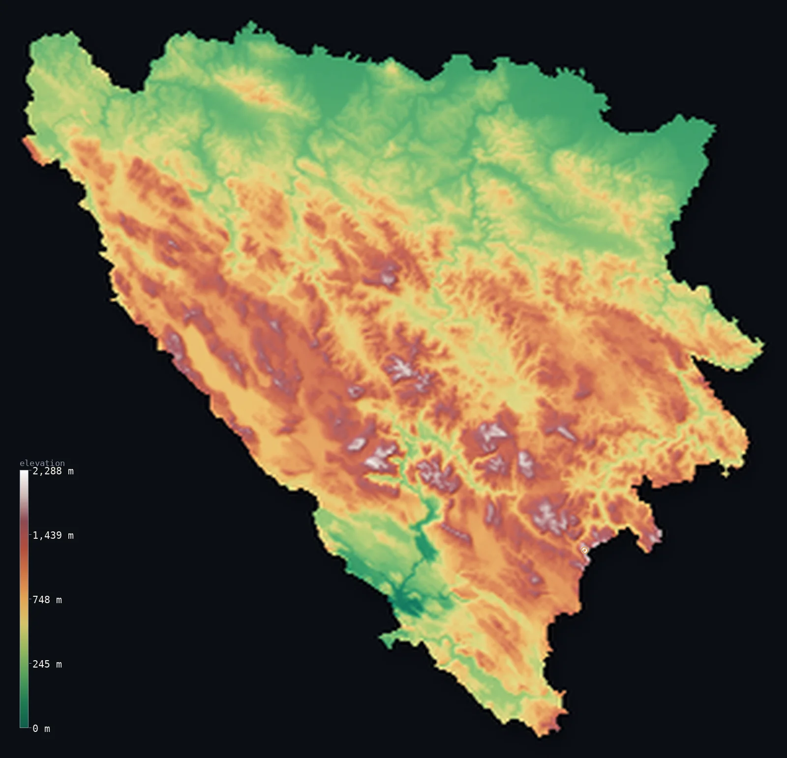
Bosnia and Herzegovina’s highest point is Maglić at 7,828 ft (2,386 m); its lowest is Adriatic Sea at 0 ft (0 m); the mean elevation is 2,267 ft (691 m).
Bosnia and Herzegovina is a country of mountains and karst. The Dinaric Alps fill most of it — a broad, rugged interior of forested ranges, high plateaus, and the porous limestone country that gives Herzegovina, the southern region, its bare, sun-struck character. Only in the north does the land fall away, sloping down to the plain of the Sava river on the Croatian border. The highest point is Maglić, 7,828 ft (2,386 m), on the Montenegrin border. The great majority of the country lies above 656 ft (200 m).
- Highest point📚
- 7,828 ft2,386 m
- Bosnia and Herzegovina's highest point is Maglić at 7,828 ft (2,386 m), on the southeastern border with Montenegro — a steep limestone peak in the high Dinaric ranges, standing above the glacial Trnovačko Lake. It is the summit of a country whose interior is almost entirely mountain and high plateau.
- Lowest point📚
- 0 ft0 m
- The country's lowest point is the sea at sea level — reached only at Neum, a narrow 12-mile stretch of Adriatic coast that is the country's single, small window on the sea, otherwise almost entirely landlocked. Its main lowland, though, is inland: the plain of the Sava river along the northern border.
- Mean elevation⚙
- 2,267 ft691 m
- Computed from the GLO-30 model, the country's mean elevation is 2,267 ft (691 m) — a high average that fits the terrain: Dinaric mountain and karst plateau cover almost the whole interior, and only the northern Sava lowland and the river valleys lie low.
- Median elevation⚙
- 2,185 ft666 m
- Half of Bosnia and Herzegovina lies above 2,185 ft (666 m) — so close to the mean that the two nearly coincide, the sign of a country upland almost everywhere: broadly mountainous rather than a land of plain-and-peak extremes, with the northern Sava plain its one real lowland.
- Elevation range📚
- 7,828 ft2,386 m
- Bosnia and Herzegovina's relief spans about 7,830 ft in all — but the coast at Neum is a technicality; the real climb is inland, range after range of Dinaric mountain and karst plateau rising to Maglić and the high southeastern peaks.
- Above 1,000 m (3,281 ft)⚙
- 25%
- About 25% of Bosnia and Herzegovina rises above 1,000 m (3,281 ft) — the Dinaric ranges and high plateaus that cover much of the interior, especially the higher country of the south and southeast. The northern Sava lowland lies well below.
- Official area📚
- 19,767 mi²51,197 km²
- Bosnia and Herzegovina covers about 19,800 sq mi (51,197 sq km) — a country in the western Balkans, mostly mountainous Dinaric interior, sloping to the Sava plain in the north and reaching the Adriatic only at the short Neum coast.
- Forest cover📚
- 42.7%
- About 42.7% of Bosnia and Herzegovina is forested — heavily wooded across the Dinaric ranges of the centre and east, while the karst of Herzegovina in the south is barer and the Sava lowland more cultivated.
Highest and lowest points
Bosnia and Herzegovina's highest point is Maglić, 7,828 ft (2,386 m), on the southeastern border with Montenegro — a steep, grey limestone massif in the high Dinaric Alps, rising above the deep glacial Trnovačko Lake at its foot. It stands in the country's wildest terrain, near the Sutjeska National Park and the old-growth forest of Perućica, one of the last primeval forests in Europe. Maglić is shared with Montenegro on the frontier, though it is not Montenegro's own high point, which lies higher elsewhere; for Bosnia and Herzegovina it is the roof of a thoroughly mountainous country.
source ↗The country's lowest point is the Adriatic at sea level, reached at Neum — a town on a narrow strip of coast, about 20 km long, that is Bosnia and Herzegovina's only access to the sea, splitting Croatia's coast in two. It is a rare feature: a country almost entirely landlocked, with a single small seafront. The country's main lowland lies inland and north: the plain of the Sava river, along the border with Croatia, where the Dinaric mountains finally give way to flat, farmed ground draining toward the Danube.
source ↗Bosnia and Herzegovina at a glance
Bosnia and Herzegovina has just 20 km of Adriatic coast, around the town of Neum — a sliver that keeps the otherwise mountainous country from being fully landlocked.
source ↗The country's high point, Maglić, is a twin-summited massif: the Bosnian peak is 2,386 m and the Montenegrin twin just across the border is 2,388 m — two metres higher.
source ↗On Maglić's slopes lies the Perućica forest — one of the last primeval forests in Europe, protected within the country's oldest national park, Sutjeska (1962).
source ↗About two-thirds of the country is mountainous, and the Dinaric Alps largely cut it off from the Mediterranean despite lying close to the sea.
source ↗The people of the Dinaric Alps, including Bosnians, are recorded as among the tallest in the world, with very high average male height.
source ↗Herzegovina's karst is so porous that many of its rivers flow underground, surfacing through caves and springs — Vjetrenica cave alone has been explored for over 7 km.
source ↗The Bosna River, which gave the country its name, is the longest river lying entirely within Bosnia and Herzegovina, rising near Sarajevo and flowing north to the Sava.
source ↗
Elevation profile of Bosnia and Herzegovina
The largest share of land, 19%, falls in the 200–400 m band, and 61% of the territory lies above 500 m (1,640 ft).
- below 500 m (1,640 ft)39%
- 500–1,000 m36%
- 1,000–2,000 m25%
- above 2,000 m (6,562 ft)<1%
Highest peaks of Bosnia and Herzegovina
| Peak | Elevation | Range | Note |
|---|---|---|---|
| Maglić↗ | 7,828 ft2,386 m | Dinaric Alps (Sutjeska) | Highest point of Bosnia and Herzegovina, a limestone pyramid on the Montenegro border in Sutjeska National Park. |
| Volujak↗ | 7,664 ft2,336 m | Dinaric Alps | The country's second-highest mountain, just southwest of Maglić near the Montenegro border. |
| Čvrsnica (Pločno)↗ | 7,310 ft2,228 m | Dinaric Alps (Herzegovina) | The most prominent peak in the country, the high point of the Čvrsnica massif in Herzegovina. |
| Prenj (Zelena glava)↗ | 7,070 ft2,155 m | Dinaric Alps (Herzegovina) | A rugged high massif above the Neretva, sometimes called the 'Bosnian Himalaya' for its alpine character. |
| Bjelašnica↗ | 6,781 ft2,067 m | Dinaric Alps (central) | An Olympic mountain above Sarajevo, host of the 1984 Winter Games alpine events. |
The Dinaric interior, the karst south, and the Sava plain
The Dinaric interior (Bosnia)
Most of the country — the region of Bosnia proper — is Dinaric mountain: range after range of forested limestone mountains and high plateaus, cut by river valleys and gorges, filling the centre and east. Rugged and wooded, holding Sarajevo in a mountain basin, it is the country's mountainous heart.
The karst south (Herzegovina)
The southern region, Herzegovina, is limestone karst country — barer, hotter, and drier than the north, a landscape of white stone, sinkholes, disappearing rivers, and the green valley of the Neretva running down toward the Adriatic. High plateaus and poljes mark this porous, sun-struck south.
The Sava lowland and the north
Along the northern border with Croatia the Dinaric mountains slope down at last to the plain of the Sava river — the country's main lowland, flat and fertile farmland draining north toward the Danube. It is the lowest and most open ground in an otherwise mountainous country.
How to read this map
Color shows elevation; the raised relief shows real terrain. On this map Bosnia and Herzegovina reads as mostly upland — browns and whites of Dinaric ranges and karst plateaus filling the centre, south, and east, highest toward Maglić on the southeastern border, sloping to the low green of the Sava plain along the northern edge, with only the tiniest touch of coast at Neum.
The 3D relief is the actual GLO-30 elevation data, exaggerated vertically so the mountainous interior and the northern lowland both show; the ×N relief slider controls how much. Tap anywhere to read that point's exact elevation.
City elevations in Bosnia and Herzegovina
The country's cities sit mostly in mountain basins and river valleys — Sarajevo in a basin ringed by mountains, Banja Luka in the northwest toward the Sava lowland, Mostar in the Neretva valley of Herzegovina, Tuzla and Zenica in the interior. Few sit high; the towns are in the valleys, not on the ranges.
| City | Population | Elevation |
|---|---|---|
| Sarajevocapitalthe capital, in a basin ringed by Dinaric mountains ↗ | 696,731 | 1,680 ft512 m |
| Banja Lukain the northwest, toward the Sava lowland ↗ | 221,106 | 512 ft156 m |
| Zenicain the central Bosna valley, an industrial city ↗ | 164,423 | 1,070 ft326 m |
| Tuzlain the northeast, in the interior hills ↗ | 142,486 | 755 ft230 m |
| Mostarin the Neretva valley of Herzegovina, in the karst south ↗ | 104,518 | 213 ft65 m |
| Bihaćin the far northwest, on the Una near the Croatian border ↗ | 75,641 | 728 ft222 m |
| Slavonski Brod | 45,005 | 305 ft93 m |
| Bugojnoin a central mountain basin on the Vrbas ↗ | 41,378 | 1,864 ft568 m |
| Brčkoin the far north on the Sava, in the Brčko District ↗ | 38,968 | 318 ft97 m |
| Bijeljinain the northeast corner, on the Semberija plain near the Sava ↗ | 37,692 | 308 ft94 m |
Elevation sampled at each city centre from the Copernicus GLO-30 model. Cities and population from GeoNames (CC-BY 4.0).
Bosnia and Herzegovina in comparison
Bosnia and Herzegovina's terrain rises 7,828 ft (2,386 m) from sea level to Maglić — about 27% of the height of Mount Everest, the world's highest point at 29,032 ft (8,849 m).
- Croatia's mean elevation is 1,027 ft — 1,240 ft lower; its high point, Dinara (Sinjal), reaches 6,007 ft (1,831 m), 1,821 ft below. Croatia elevation map →
- Montenegro's mean elevation is 3,386 ft — 1,119 ft higher; its high point, Zla Kolata, reaches 8,314 ft (2,534 m), 486 ft above. Montenegro elevation map →
- Serbia's mean elevation is 1,352 ft — 915 ft lower; its high point, Midzor, reaches 7,116 ft (2,169 m), 712 ft below. Serbia elevation map →
Frequently asked questions
What is the highest point in Bosnia and Herzegovina?
- Maglić, 7,828 ft (2,386 m), on the southeastern border with Montenegro — a steep limestone peak in the high Dinaric Alps, above the glacial Trnovačko Lake.
What is the lowest point in Bosnia and Herzegovina?
- The Adriatic Sea at sea level, reached only at Neum — a 20 km strip of coast that is the country's single window on the sea. Its main lowland is inland, the Sava plain in the north.
What is the average elevation of Bosnia and Herzegovina?
- Computed from the Copernicus GLO-30 model, the area-weighted mean is 2,267 ft (691 m) — high, because the country is mostly Dinaric mountain and karst plateau, with low ground only in the northern Sava plain.
Is Bosnia and Herzegovina landlocked?
- Almost — it has just a 20 km stretch of Adriatic coast at Neum, its only access to the sea, which splits Croatia's coastline. The rest of the country is landlocked, mostly mountainous interior.
What is the difference between Bosnia and Herzegovina?
- They are the country's two regions — Bosnia, the larger, mountainous and forested north and centre, and Herzegovina, the barer limestone karst of the south, drier and hotter, drained by the Neretva toward the Adriatic.
Is this a topographic, relief, contour, or elevation map of Bosnia and Herzegovina?
- They describe the same thing — terrain height. This page renders the country's actual elevation surface in interactive 3D and reports the statistics computed from it.
About this map
The terrain is rendered from the Copernicus GLO-30 digital elevation model (ESA), masked to the BIH-ADM0 boundary from geoBoundaries (gbOpen). Elevation statistics are computed directly from the model; peak names and researched facts are sourced and cited. See the methodology for the full pipeline.
Our area-weighted mean, computed from the Copernicus GLO-30 model, is 2,267 ft (691 m); the figure commonly cited elsewhere is 1,640 ft (500 m) (CIA World Factbook). About two-thirds of the country is Dinaric mountain and karst plateau, with lowland only along the northern Sava valley and the sliver of Adriatic coast at Neum — so its area-weighted mean elevation is high. The commonly-cited 500 m understates this, sitting well below the mountainous interior; the page reports the figure computed from the Copernicus GLO-30 model.
Surveyed national figures: official area · forest cover · high point.
Rendered from Copernicus GLO-30 (ESA, 2021 release), boundaries from geoBoundaries. Generated 2026-06-22.
Bordering countries · 3
Bosnia and Herzegovina shares a land border with these countries — open any one to compare its terrain and highest point.