Serbia Elevation Map — Topographic & 3D Terrain
Explore the terrain of Serbia in interactive 3D, built from Copernicus GLO-30 satellite elevation data — a landlocked crossroads where the Pannonian plain meets three mountain systems. Drag to rotate, scroll to zoom, and tap any point to read its elevation.
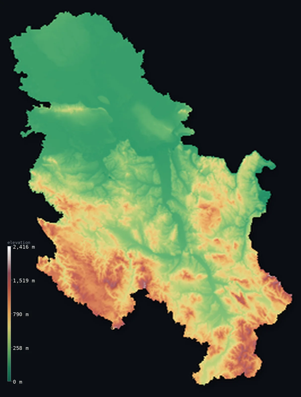
Serbia’s highest point is Midzor at 7,116 ft (2,169 m); its lowest is Danube and Timok confluence at 115 ft (35 m); the mean elevation is 1,352 ft (412 m).
Serbia is a meeting of landscapes. In the north lies the flat Pannonian plain of Vojvodina, an extension of the great Hungarian lowland; but southward the country rises into hills and mountains where three systems come together — the Dinaric Alps reaching in from the west, the Carpathians from the northeast, and the Balkan Mountains from the southeast. The Danube and its tributaries the Sava and Morava thread between them. Within the mapped borders the highest point is Midžor, 7,116 ft (2,169 m), on the Bulgarian frontier.
- Highest point📚
- 7,116 ft2,169 m
- The highest point within Serbia's mapped borders is Midžor at 7,116 ft (2,169 m), on the Stara Planina — the Balkan Mountains — along the frontier with Bulgaria in the southeast. Serbia's terrain is highest here, where the Balkan range enters the country. (This map follows the geoBoundaries outline, which does not include Kosovo; Serbia also claims Kosovo, where the land rises higher still — to about 2,660 m, above Midžor.)
- Lowest point📚
- 115 ft35 m
- Serbia's lowest point is where the Danube leaves the country in the east, near the Timok confluence, at about 115 ft (35 m) — low, but well above sea level, as Serbia is landlocked and drains through the Danube toward the distant Black Sea.
- Mean elevation⚙
- 1,352 ft412 m
- Computed from the GLO-30 model, Serbia's mean elevation is 1,352 ft (412 m) — the average of a country pulled two ways: the flat Pannonian plain of the north holds it down, the mountains gathering in the south and east push it back up.
- Median elevation⚙
- 902 ft275 m
- Half of Serbia lies below 902 ft (275 m) — and the figure marks the divide in the country: the flat Vojvodina plain in the north sits low, while the southern two-thirds climbs into hill and mountain, so the typical point falls between the two, on the rising ground where plain gives way to upland.
- Elevation range📚
- 7,001 ft2,134 m
- From the Danube's exit to the summit of Midžor, Serbia's mapped terrain spans about 7,000 ft — from the low northern river plain to the Balkan peaks of the southeastern border, the height gathering in the country's mountainous south.
- Above 1,000 m (3,281 ft)⚙
- 10%
- About 10% of Serbia rises above 1,000 m (3,281 ft) — the mountains of the south and east, where the Dinaric, Carpathian, and Balkan systems reach into the country. The northern Pannonian plain lies far below.
- Official area📚
- 29,913 mi²77,474 km²
- Serbia's mapped area is about 29,900 sq mi (77,474 sq km) — a landlocked country in the central Balkans where the Pannonian plain of the north meets the mountains of the south, drained by the Danube, Sava, and Morava. (This figure follows the geoBoundaries outline and does not include Kosovo, which Serbia claims.)
- Forest cover📚
- 31.6%
- About 31.6% of Serbia is forested — much of it on the southern and eastern mountains, whose slopes carry beech and oak; the northern Vojvodina plain is open farmland, some of the most fertile in the region.
Highest and lowest points
The highest point within Serbia's mapped borders is Midžor, 7,116 ft (2,169 m), on the Stara Planina — the Balkan Mountains — on the frontier with Bulgaria in the southeast. It is a broad, grassy summit where the Balkan range crosses into Serbia, in the country's mountainous southeast. This map follows the geoBoundaries outline, which does not include Kosovo; Serbia also claims Kosovo, where the land rises higher than Midžor — to about 2,660 m at Velika Rudoka in the Šar Mountains, with the better-known Đeravica (2,656 m) in the Prokletije nearby, both in the far southwest and both outside the boundary shown here. The map reports the terrain within the outline without taking a position on the dispute.
source ↗Serbia's lowest point is where the Danube flows out of the country in the far east, near the mouth of the Timok on the Romanian and Bulgarian borders, at about 115 ft (35 m) above sea level. Landlocked Serbia drains almost entirely through the Danube, which crosses the north of the country — carving the dramatic Iron Gates gorge through the Carpathian spur on the Romanian border — and carries the country's waters east toward the far-off Black Sea. Even this lowest ground sits well above the sea.
source ↗Serbia at a glance
Serbia is a landlocked crossroads where three mountain systems meet — the Dinaric Alps from the west, the Carpathians from the northeast, and the Balkan Mountains from the southeast — around the plains of the north.
source ↗Northern Serbia — the Vojvodina — is part of the flat Pannonian plain, an extension of the great Hungarian lowland, and the country's most fertile farmland.
source ↗The Danube crosses northern Serbia and, on the Romanian border, carves the Iron Gates — one of the largest and most dramatic river gorges in Europe.
source ↗The highest point within Serbia's mapped borders is Midžor (2,169 m) on the Bulgarian frontier; higher ground — about 2,660 m — lies in Kosovo, which Serbia claims but which the map's boundary excludes.
source ↗The Sava and the Morava, Serbia's great rivers, meet the Danube near Belgrade, which stands at their confluence at the meeting of plain and hill.
source ↗Serbia's southern and eastern mountains hold deep river gorges and some of the country's wildest terrain, where the Dinaric, Carpathian, and Balkan systems come together.
source ↗
Elevation profile of Serbia
The largest share of land, 42%, falls in the 0–200 m band, and 67% of the territory lies below 500 m (1,640 ft).
- below 500 m (1,640 ft)67%
- 500–1,000 m23%
- 1,000–2,000 m10%
- above 2,000 m (6,562 ft)<1%
Highest peaks of Serbia
| Peak | Elevation | Range | Note |
|---|---|---|---|
| Midzor↗ | 7,116 ft2,169 m | Stara Planina (Balkan Mountains) | Highest point of Serbia proper, on the Bulgaria border in the east. |
| Pancic's Peak↗ | 6,617 ft2,017 m | Kopaonik | The high point of the Kopaonik massif in southern Serbia, a major ski area. |
| Jankov Kamen↗ | 6,014 ft1,833 m | Golija | The summit of the Golija massif in southwestern Serbia, a UNESCO biosphere reserve. |
| Kozji Rid↗ | 5,220 ft1,591 m | Tara | A high point of the Tara mountain in the west, above the Drina river canyon. |
| Crveni Cot↗ | 1,768 ft539 m | Fruska Gora | The highest point of the Fruska Gora hills that rise from the Pannonian plain in the north. |
The crossroads: plain, hills, and three mountain systems
The Pannonian plain (Vojvodina)
Northern Serbia is flat — the Vojvodina, part of the great Pannonian plain that centres on Hungary, an extension of the same lowland reaching south across the Danube. Fertile, open, and low, it is the country's breadbasket and its lowest, flattest ground.
The central hills and river valleys
South of the Danube and Sava the land rises into hills cut by river valleys — above all the Morava, whose broad valley runs south through the centre of the country, the main corridor between the northern plain and the southern mountains. Belgrade stands where the rivers meet.
The southern and eastern mountains
The southern two-thirds of Serbia is mountainous, where three systems converge — the Dinaric Alps reaching in from the west, the Carpathians curving down from the northeast, and the Balkan Mountains (the Stara Planina, holding Midžor) along the Bulgarian border in the southeast. Deep gorges, forests, and the country's highest ground.
How to read this map
Color shows elevation; the raised relief shows real terrain. On this map Serbia reads as a country split north to south — the flat green Pannonian plain filling the north beyond the Danube, giving way southward to brown hills and then the mountains gathering along the southern and eastern borders, highest toward Bulgaria.
The 3D relief is the actual GLO-30 elevation data, exaggerated vertically so the northern plain and the southern mountains both show; the ×N relief slider controls how much. Tap anywhere to read that point's exact elevation.
City elevations in Serbia
Serbia's cities follow the rivers and the plain — Belgrade at the meeting of the Sava and Danube, Novi Sad on the Danube in the northern plain, Niš in the Morava valley of the south, others along the river corridors. Most sit on lower ground, below the mountains.
| City | Population | Elevation |
|---|---|---|
| Belgradecapitalthe capital, at the confluence of the Sava and the Danube, where the plain meets the hills ↗ | 1,273,651 | 390 ft119 m |
| Nišin the Morava valley of the south, a crossroads city ↗ | 250,000 | 636 ft194 m |
| Novi Sadon the Danube in the Vojvodina plain to the north ↗ | 215,400 | 269 ft82 m |
| Kragujevacin the Šumadija hills of central Serbia ↗ | 147,473 | 607 ft185 m |
| Čačakin the West Morava valley of central Serbia ↗ | 117,072 | 797 ft243 m |
| Suboticain the far north, on the Pannonian plain near the Hungarian border ↗ | 100,000 | 384 ft117 m |
| Leskovacin the South Morava valley of the south ↗ | 94,758 | 751 ft229 m |
| Novi Pazarin the hills of the southwest, the highest of the major cities ↗ | 85,996 | 1,673 ft510 m |
| Drobeta-Turnu Severin | 79,865 | 253 ft77 m |
| Zrenjaninon the Begej in the Vojvodina plain to the north ↗ | 79,773 | 266 ft81 m |
Elevation sampled at each city centre from the Copernicus GLO-30 model. Cities and population from GeoNames (CC-BY 4.0).
Serbia in comparison
Serbia's terrain rises 7,001 ft (2,134 m) from Danube and Timok confluence (115 ft (35 m)) to Midzor — about 24% of the height of Mount Everest, the world's highest point at 29,032 ft (8,849 m).
- Bulgaria's mean elevation is 1,562 ft — 210 ft higher; its high point, Musala, reaches 9,596 ft (2,925 m), 2,480 ft above. Bulgaria elevation map →
- Romania's mean elevation is 1,312 ft — 39 ft lower; its high point, Moldoveanu, reaches 8,346 ft (2,544 m), 1,230 ft above. Romania elevation map →
- Bosnia and Herzegovina's mean elevation is 2,267 ft — 915 ft higher; its high point, Maglić, reaches 7,828 ft (2,386 m), 712 ft above. Bosnia and Herzegovina elevation map →
Frequently asked questions
What is the highest point in Serbia?
- Within the boundary this map follows (which excludes Kosovo), Midžor, 7,116 ft (2,169 m), on the Bulgarian frontier. Serbia also claims Kosovo, where the land rises higher still — to about 2,660 m, above Midžor.
What is the lowest point in Serbia?
- Where the Danube leaves the country in the far east, at about 115 ft (35 m) — low, but well above sea level, as Serbia is landlocked.
What is the average elevation of Serbia?
- Computed from the Copernicus GLO-30 model, the area-weighted mean is 1,352 ft (412 m) — moderate, balancing the flat northern Pannonian plain against the mountains of the south and east.
Which boundary does this map use for Serbia?
- It follows the geoBoundaries outline, which does not include Kosovo — a territory Serbia claims but which declared independence and is disputed. The map reports the terrain within that outline, and notes that the higher ground Serbia claims — about 2,660 m, above Midžor — lies in Kosovo. It takes no position on the dispute.
Where do the mountains meet in Serbia?
- In the south — the Dinaric Alps reach in from the west, the Carpathians curve down from the northeast, and the Balkan Mountains run along the Bulgarian border in the southeast, all gathering in Serbia's mountainous southern two-thirds.
Is this a topographic, relief, contour, or elevation map of Serbia?
- They describe the same thing — terrain height. This page renders the country's actual elevation surface in interactive 3D and reports the statistics computed from it.
About this map
The terrain is rendered from the Copernicus GLO-30 digital elevation model (ESA), masked to the SRB-ADM0 boundary from geoBoundaries (gbOpen). Elevation statistics are computed directly from the model; peak names and researched facts are sourced and cited. See the methodology for the full pipeline.
Our area-weighted mean, computed from the Copernicus GLO-30 model, is 1,352 ft (412 m); the figure commonly cited elsewhere is 1,450 ft (442 m) (CIA World Factbook). Serbia runs from the flat Pannonian plain in the north - barely above the Danube - up to mountains above 2,000 m in the centre, east and south, giving a moderate mean; the page reports the area-weighted figure computed from the Copernicus GLO-30 model over the rendered boundary.
Surveyed national figures: official area · forest cover · high point.
Rendered from Copernicus GLO-30 (ESA, 2021 release), boundaries from geoBoundaries. Generated 2026-06-26.
Bordering countries · 8
Serbia shares a land border with these countries — open any one to compare its terrain and highest point.