Kosovo Elevation Map — Topographic & 3D Terrain
Explore the terrain of Kosovo in interactive 3D, built from Copernicus GLO-30 satellite elevation data — a high inland basin ringed by mountains on every side. Drag to rotate, scroll to zoom, and tap any point to read its elevation.
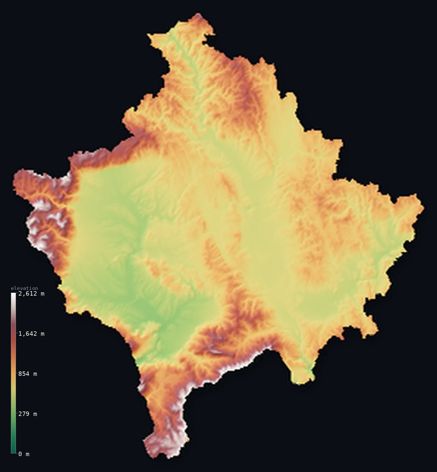
Kosovo’s highest point is Gjeravica (Deravica) at 8,714 ft (2,656 m); its lowest is White Drin (Drini i Bardhe) valley at 974 ft (297 m); the mean elevation is 2,654 ft (809 m).
Kosovo is a high basin held within mountains. A small, landlocked territory in the central Balkans, it sits entirely above 656 ft (200 m) — a floor of rolling plains and valleys, the Kosovo and Dukagjini basins, enclosed on every side by mountain ranges. The Šar Mountains wall it to the south along the North Macedonian border, and the Accursed Mountains — the Prokletije — rise to the west, where Đeravica reaches 8,714 ft (2,656 m). Even the lowest ground, where the White Drin leaves the territory, lies close to 1,000 ft above the sea.
- Highest point📚
- 8,714 ft2,656 m
- Kosovo's highest point is Đeravica (Gjeravica) at 8,714 ft (2,656 m), in the Accursed Mountains — the Prokletije — on the western edge of the territory. It is a glacially-sculpted peak of the range that walls Kosovo to the west, its slopes holding cirques and small mountain lakes. (The ridge of the Šar Mountains, on the North Macedonian border to the south, rises marginally higher still, to about 2,660 m at Velika Rudoka.)
- Lowest point📚
- 974 ft297 m
- Kosovo's lowest point is where the White Drin (Drini i Bardhë) flows out of the territory to the southwest, at about 974 ft (297 m) — remarkably high for a lowest point, because Kosovo is a raised basin: even its lowest ground sits far above the sea, and every part of the territory lies above 200 m.
- Mean elevation⚙
- 2,654 ft809 m
- Computed from the GLO-30 model, Kosovo's mean elevation is 2,654 ft (809 m) — high not for any towering peak but because of the floor: even the basins that hold the territory's low ground sit well above sea level, and the ranges ringing them lift the average further.
- Median elevation⚙
- 2,257 ft688 m
- Half of Kosovo lies below 2,257 ft (688 m) — but the more telling figure is that none of it lies below 200 m at all: Kosovo is the rare territory entirely above that line, a basin whose floor is already upland and whose rim climbs to 2,600 m.
- Elevation range📚
- 7,740 ft2,359 m
- Kosovo's relief spans about 7,740 ft top to bottom — but both ends sit high: the lowest ground, where the White Drin leaves the territory, is already near 1,000 ft up, and the whole rise to Đeravica is packed within the encircling mountains.
- Above 1,000 m (3,281 ft)⚙
- 21%
- About 21% of Kosovo rises above 1,000 m (3,281 ft) — the Šar Mountains, the Prokletije, and the other ranges that ring the territory. The basins they enclose are lower, but still upland: the whole of Kosovo lies above 200 m.
- Above 2,000 m (6,562 ft)⚙
- 2%
- Roughly 2% of Kosovo stands above 2,000 m (6,562 ft) — the higher crests of the encircling ranges, the Prokletije around Đeravica in the west and the Šar Mountains along the southern border.
- Official area📚
- 4,203 mi²10,887 km²
- Kosovo covers about 4,200 sq mi (10,887 sq km) — a small, landlocked territory in the central Balkans, a high basin of plains and valleys ringed by the Šar Mountains, the Prokletije, and other ranges. Its independence, declared in 2008, is recognized by many states but disputed by Serbia, which claims the territory; this map follows the geoBoundaries outline and reports the terrain within it without taking a position.
- Forest cover📚
- 42%
- About 42.0% of Kosovo is forested — much of it on the encircling mountain ranges, whose slopes carry beech and conifer; the basin floors are more open, farmed lowland.
Highest and lowest points
Kosovo's highest point is Đeravica — Gjeravica in Albanian — at 8,714 ft (2,656 m), in the Accursed Mountains, the Prokletije, on Kosovo's western edge. It is a glacially-carved peak of grey rock, its slopes cradling cirques and small glacial lakes, in the range that walls the territory to the west and continues into Albania and Montenegro. Đeravica is the traditional and most-cited high point of Kosovo. Along the southern border, the ridge of the Šar Mountains rises marginally higher — to about 2,660 m at Velika Rudoka, on the frontier with North Macedonia — so the very highest ground touched by Kosovo's boundary is on that southern ridge; but Đeravica, standing clear within the Prokletije, is the peak by which Kosovo's height is known. (Serbia also claims Kosovo, and the published Serbia map notes these same summits as lying beyond its own boundary; this map, following the geoBoundaries outline, shows them as Kosovo's terrain, and takes no position on the dispute.)
source ↗Kosovo's lowest point is where the White Drin — the Drini i Bardhë — flows out of the territory to the southwest, toward Albania, at about 974 ft (297 m) above sea level. It is an unusually high lowest point, and it captures what makes Kosovo distinctive: the whole territory is a raised basin, its floor already well above the sea, so even the lowest ground stands high. Kosovo lies entirely above 200 m — one of very few territories anywhere of which that is true — draining through the White Drin toward the Adriatic and, on the other side of its watershed, through the Sitnica and Ibar toward the Danube.
source ↗Kosovo at a glance
Although Kosovo is small and landlocked, its rivers drain to three different seas: the White Drin to the Adriatic, the Sitnica and Ibar to the Black Sea, and the Lepenac to the Aegean.
source ↗Kosovo's highest peak is contested: Gjeravica (2,656 m) is the highest point entirely inside the country, but Velika Rudoka in the Sharr Mountains is 2-4 m taller and straddles the North Macedonia border.
source ↗The Accursed Mountains (Bjeshket e Nemuna) that hold Gjeravica are considered among the most inaccessible and wildest ranges in Europe.
source ↗The mountains hold many small glacial lakes - remnants of Ice Age glaciation - set in steep limestone karst, though no permanent ice survives today.
source ↗Even the lowest point in Kosovo lies at 297 m - the country is so mountain-ringed it never drops near sea level.
source ↗Kosovo declared independence in 2008; it is recognized by about a hundred UN member states and its statehood is disputed by Serbia.
source ↗
Elevation profile of Kosovo
The largest share of land, 31%, falls in the 400–600 m band, and 83% of the territory lies above 500 m (1,640 ft).
- below 500 m (1,640 ft)17%
- 500–1,000 m63%
- 1,000–2,000 m19%
- above 2,000 m (6,562 ft)2%
Highest peaks of Kosovo
| Peak | Elevation | Range | Note |
|---|---|---|---|
| Velika Rudoka (Rudoka e Madhe)↗ | 8,720 ft2,658 m | Sharr Mountains (south) | Slightly higher than Gjeravica, but its summit straddles the border with North Macedonia, so its status as Kosovo's highest is disputed. |
| Gjeravica (Deravica)↗ | 8,714 ft2,656 m | Accursed Mountains (Prokletije, west) | The highest peak lying entirely within Kosovo, in the Accursed Mountains near the Albanian border. |
| Gusan↗ | 8,330 ft2,539 m | Accursed Mountains (Prokletije, west) | A high peak of the Accursed Mountains in western Kosovo, near Gjeravica. |
| Luboten↗ | 8,196 ft2,498 m | Sharr Mountains (south) | A prominent peak of the Sharr Mountains on the southern flank, long cited as Kosovo's highest fully-internal Sharr summit. |
| Pancic's Peak↗ | 6,617 ft2,017 m | Kopaonik (north) | The high point of the Kopaonik range on the northern border with Serbia. |
A bowl of basins ringed by mountains
The basins (the floor)
The heart of Kosovo is two upland basins — the Kosovo basin in the east, drained by the Sitnica toward the Ibar and the Danube, and the Dukagjini basin in the west, drained by the White Drin toward the Adriatic — divided by low hills. Rolling, farmed, and populous, they are the territory's floor, though even here the land lies above 200 m.
The Prokletije and the western mountains
The Accursed Mountains — the Prokletije — rise along Kosovo's western edge, a range of steep grey peaks, cirques, and glacial lakes holding Đeravica, the territory's high point, and continuing into Albania and Montenegro. The highest and wildest ground in Kosovo.
The Šar Mountains and the southern rim
Along the southern border with North Macedonia rise the Šar Mountains, a high range whose ridge marks the frontier and reaches marginally higher than Đeravica. With the other ranges that ring the territory, they complete the mountain wall enclosing the basins.
How to read this map
Color shows elevation; the raised relief shows real terrain. On this map Kosovo reads as a bowl — the rolling basin floor in mid-tones filling the centre (already upland, none of it low), ringed by the browns and whites of mountains on every side: the Prokletije to the west around Đeravica, the Šar along the south.
The 3D relief is the actual GLO-30 elevation data, exaggerated vertically so the basin floor and the encircling ranges both show; the ×N relief slider controls how much. Tap anywhere to read that point's exact elevation.
City elevations in Kosovo
Kosovo's towns sit in the upland basins — Pristina, the capital, in the eastern Kosovo basin, Prizren beneath the Šar Mountains in the southwest, Gjakovë and Deçan out in the western Dukagjini basin toward the Prokletije. All sit high, on basin ground above 200 m.
| City | Population | Elevation |
|---|---|---|
| Pristinacapitalthe capital, in the eastern Kosovo basin ↗ | 550,000 | 1,965 ft599 m |
| Prizrenin the southwest, beneath the Šar Mountains ↗ | 171,464 | 1,375 ft419 m |
| Mitrovicëin the north, on the Ibar ↗ | 107,045 | 1,677 ft511 m |
| Gjakovëin the Dukagjini basin of the west, near the Albanian border ↗ | 94,158 | 1,191 ft363 m |
| Suva Rekain the southwest, between Prizren and the central basin ↗ | 72,229 | 1,289 ft393 m |
| Ferizajin the eastern Kosovo basin, south of Pristina ↗ | 59,504 | 1,906 ft581 m |
| Glogovacin the central basin, west of Pristina ↗ | 58,579 | 1,909 ft582 m |
| Gjilanin the southeast of the Kosovo basin ↗ | 51,912 | 1,680 ft512 m |
| Deçanin the west, at the foot of the Prokletije ↗ | 50,500 | 2,011 ft613 m |
| Vitinain the southeast, near the North Macedonian border ↗ | 46,959 | 1,637 ft499 m |
Elevation sampled at each city centre from the Copernicus GLO-30 model. Cities and population from GeoNames (CC-BY 4.0).
Kosovo in comparison
Kosovo's terrain rises 7,740 ft (2,359 m) from White Drin (Drini i Bardhe) valley (974 ft (297 m)) to Gjeravica (Deravica) — about 27% of the height of Mount Everest, the world's highest point at 29,032 ft (8,849 m).
- Albania's mean elevation is 2,254 ft — 400 ft lower; its high point, Mount Korab, reaches 9,068 ft (2,764 m), 354 ft above. Albania elevation map →
- North Macedonia's mean elevation is 2,730 ft — 75 ft higher; its high point, Golem Korab, reaches 9,068 ft (2,764 m), 354 ft above. North Macedonia elevation map →
- Montenegro's mean elevation is 3,386 ft — 732 ft higher; its high point, Zla Kolata, reaches 8,314 ft (2,534 m), 400 ft below. Montenegro elevation map →
Frequently asked questions
What is the highest point in Kosovo?
- Đeravica (Gjeravica), 8,714 ft (2,656 m), in the Accursed Mountains (Prokletije) on the western border — the traditional high point of Kosovo. The Šar Mountains ridge on the southern border reaches marginally higher (~2,660 m).
What is the lowest point in Kosovo?
- Where the White Drin leaves the territory to the southwest, at about 974 ft (297 m) — an unusually high lowest point, because the whole territory is a raised basin lying above 200 m.
What is the average elevation of Kosovo?
- Computed from the Copernicus GLO-30 model, the area-weighted mean is 2,654 ft (809 m) — high for so small a territory, because Kosovo is a raised basin ringed by mountains, with no low ground at all.
Is Kosovo mountainous?
- It is a high basin ringed by mountains — the basin floor is upland (the whole territory lies above 200 m), and the Prokletije to the west and the Šar Mountains to the south rise above 2,600 m.
Which boundary does this map use for Kosovo?
- It follows the geoBoundaries outline of Kosovo, whose independence (declared 2008) is recognized by many states but disputed by Serbia, which claims the territory. The map reports the terrain within that outline and takes no position on the dispute.
Is this a topographic, relief, contour, or elevation map of Kosovo?
- They describe the same thing — terrain height. This page renders the territory's actual elevation surface in interactive 3D and reports the statistics computed from it.
About this map
The terrain is rendered from the Copernicus GLO-30 digital elevation model (ESA), masked to the XKX-ADM0 boundary from geoBoundaries (gbOpen). Elevation statistics are computed directly from the model; peak names and researched facts are sourced and cited. See the methodology for the full pipeline.
Our area-weighted mean, computed from the Copernicus GLO-30 model, is 2,654 ft (809 m); the figure commonly cited elsewhere is 1,476 ft (450 m) (CIA World Factbook). Kosovo is a raised basin — two central plains around 500-600 m ringed by high mountains, its lowest point already near 300 m — so its area-weighted mean elevation is high. The commonly-cited 450 m sits below the basin floor itself and understates the mountain-ringed terrain; the page reports the area-weighted figure computed from the Copernicus GLO-30 model.
Surveyed national figures: official area · forest cover · high point.
Rendered from Copernicus GLO-30 (ESA, 2021 release), boundaries from geoBoundaries. Generated 2026-06-23.
Bordering countries · 4
Kosovo shares a land border with these countries — open any one to compare its terrain and highest point.