Albania Elevation Map — Topographic & 3D Terrain
Explore the terrain of Albania in interactive 3D, built from Copernicus GLO-30 satellite elevation data — a mountainous country dropping from high interior ranges to a narrow Adriatic coast. Drag to rotate, scroll to zoom, and tap any point to read its elevation.
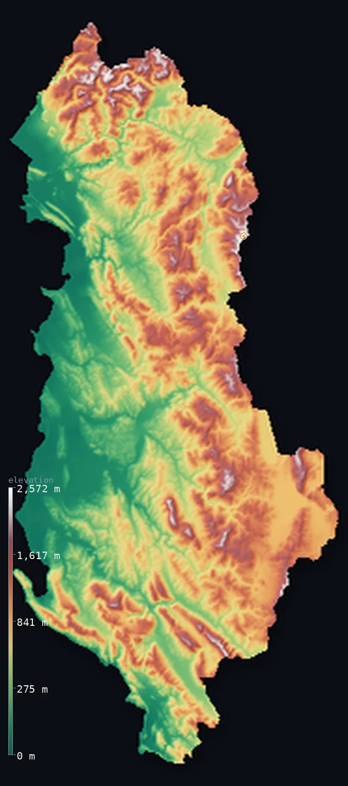
Albania’s highest point is Mount Korab at 9,068 ft (2,764 m); its lowest is Adriatic Sea at 0 ft (0 m); the mean elevation is 2,254 ft (687 m).
Albania is mostly mountains, tilted toward the sea. A narrow coastal plain runs along the Adriatic and Ionian in the west, but behind it the land rises quickly into rugged interior highlands that cover most of the country — the Accursed Mountains (the Prokletije) in the north, the ranges continuing south as the northern reach of the Pindus. The highest point is Korab, 9,068 ft (2,764 m), shared with North Macedonia on the eastern border. About three-quarters of Albania stands above 656 ft (200 m).
- Highest point📚
- 9,068 ft2,764 m
- Albania's highest point is Korab at 9,068 ft (2,764 m), on the eastern border with North Macedonia — the highest peak of both countries, standing exactly on the frontier that runs across its summit. It is the high point of the Korab range, part of the mountainous spine that fills eastern Albania, and the tallest mountain in a country that is overwhelmingly upland.
- Lowest point📚
- 0 ft0 m
- Albania's lowest point is the sea at sea level, along the Adriatic and Ionian coasts of the west — the narrow coastal plain that is the country's main lowland, backed almost immediately by rising mountains.
- Mean elevation⚙
- 2,254 ft687 m
- Computed from the GLO-30 model, Albania's mean elevation is 2,254 ft (687 m) — the interior does the lifting: rugged highlands cover most of the country and hold the average up, while only the thin western coastal plain sits low.
- Median elevation⚙
- 2,031 ft619 m
- Half of Albania lies below 2,031 ft (619 m) — lower than the mean, because the narrow coastal plain and the river valleys sit far down while the high interior ranges pull the average up past the midpoint; most of the land is the rising slope between coast and summit.
- Elevation range📚
- 9,068 ft2,764 m
- Albania rises about 9,070 ft overall — a wide reach for a small country, but a lopsided one: a thin coastal plain in the west, then interior ranges that carry almost all the height up to Korab on the eastern border.
- Above 1,000 m (3,281 ft)⚙
- 28%
- About 28% of Albania rises above 1,000 m (3,281 ft) — the interior highlands and mountain ranges, from the Prokletije in the north down the eastern border. The coastal plain of the west is far lower.
- Above 2,000 m (6,562 ft)⚙
- 1%
- Roughly 1% of Albania stands above 2,000 m (6,562 ft) — the highest ground, the Prokletije around the northern border and the Korab range on the eastern frontier.
- Official area📚
- 11,100 mi²28,748 km²
- Albania covers about 11,100 sq mi (28,748 sq km) — a small country on the western Balkan coast, mountainous across most of its interior, with a narrow coastal plain along the Adriatic and Ionian seas.
- Forest cover📚
- 28.8%
- About 28.8% of Albania is forested — much of it on the interior mountains, whose slopes carry oak and beech; the coastal plain and the lower valleys are more cultivated, and the far south has Mediterranean scrub.
Highest and lowest points
Albania's highest point is Korab, 9,068 ft (2,764 m), on the eastern border — and it is the highest peak of both Albania and North Macedonia, its summit lying exactly on the frontier between them. It is the tallest of the Korab range, a high massif on the border, and the roof of a country that is mountainous almost throughout. The northern mountains of Albania — the Accursed Mountains, or Prokletije — are wilder and more dramatic still, a maze of steep grey karst peaks and deep valleys shared with Montenegro and Kosovo, even if Korab, to the east, edges them in height.
source ↗Albania's lowest point is the sea at sea level, along a coast that runs the length of the country's western edge — the Adriatic in the north, curving south past the port of Durrës and around to the Ionian in the far south, where the Albanian Riviera's steep shore faces the island of Corfu. The coastal plain behind it is the country's principal lowland, fertile and populous, but narrow: within a short distance inland the ground begins to climb into the mountains that make up most of Albania.
source ↗Albania at a glance
Mount Korab is one of the few summits in Europe that is the highest point of two countries at once — like Mont Blanc, shared by France and Italy — its peak lying exactly on the Albania–North Macedonia border.
source ↗Albania's average elevation, about 708 m, is more than twice the European average — roughly three-quarters of the country is mountains and hills.
source ↗The northern Albanian Alps are known as Bjeshkët e Nëmuna — the 'Accursed Mountains' — a name thought to come from their rough, rocky, heavily forested and forbidding terrain.
source ↗Maja e Jezercës (2,694 m) in the Albanian Alps is the highest peak of the entire Dinaric Alps (though Korab, in a separate range, is higher), the long range running down the eastern Adriatic.
source ↗Along the Albanian Riviera the Ceraunian Mountains rise straight from the Ionian Sea, so peaks above 2,000 m stand within a few kilometres of the beach.
source ↗Mount Tomorr near Berat is a sacred mountain in Albanian folklore, believed to be the home of the mythical Baba Tomor, with an annual pilgrimage to its heights.
source ↗Albania faces two seas — the Adriatic to the northwest and the Ionian to the southwest — meeting near the Karaburun Peninsula and the narrow Strait of Otranto toward Italy.
source ↗
Elevation profile of Albania
The largest share of land, 22%, falls in the 0–200 m band, and 57% of the territory lies above 500 m (1,640 ft).
- below 500 m (1,640 ft)43%
- 500–1,000 m29%
- 1,000–2,000 m27%
- above 2,000 m (6,562 ft)1%
Highest peaks of Albania
| Peak | Elevation | Range | Note |
|---|---|---|---|
| Mount Korab↗ | 9,068 ft2,764 m | Korab Mountains | Highest point of Albania and North Macedonia, on their shared border; a rugged gypsum-limestone massif. |
| Maja e Jezercës↗ | 8,839 ft2,694 m | Albanian Alps (Accursed Mountains) | Highest peak of the Albanian Alps and of the entire Dinaric Alps, a limestone giant in the north. |
| Gjallica↗ | 8,166 ft2,489 m | near the Korab system (Kukës) | A dramatic peak above the town of Kukës in the northeast. |
| Maja e Papingut↗ | 8,143 ft2,482 m | Nemërçkë | Highest peak of the Nemërçkë range in the south, near the Greek border. |
| Tomorr↗ | 7,927 ft2,416 m | Tomorr (central) | A sacred massif near Berat, central to Albanian folklore as the home of Baba Tomor. |
| Maja e Çikës↗ | 6,709 ft2,045 m | Ceraunian Mountains (Riviera) | Highest peak of the coastal Ceraunian Mountains that rise straight from the Ionian Riviera. |
Albania from the coast to the interior ranges
The coastal plain (west)
Along the western edge of Albania, on the Adriatic and Ionian seas, runs the coastal plain — the country's main lowland, fertile, populous, and holding the ports of Durrës and Vlorë. It is narrow, though: backed almost at once by rising hills and mountains, it is a thin fringe on a mountainous country.
The northern and interior mountains
Most of Albania is mountain — the Accursed Mountains (Prokletije) in the north, a wild maze of karst peaks shared with Montenegro and Kosovo, and the ranges that fill the interior and run down the eastern border, holding Korab. Rugged, forested, and deeply cut by river valleys, they are the bulk of the country.
The southern mountains and lakes
Southern Albania is also upland — the mountains continue as the northern Pindus toward Greece, and the southeastern border holds the ancient lakes of Ohrid and Prespa, high among the ranges. The Ionian coast here, the Albanian Riviera, is steep and scenic, mountains dropping straight to the sea.
How to read this map
Color shows elevation; the raised relief shows real terrain. On this map Albania reads as a mountainous country with a thin coastal edge — a narrow band of low green along the western Adriatic and Ionian coast, giving way almost at once to the browns and whites of the interior highlands, the Prokletije in the north and the ranges down the eastern border toward Korab.
The 3D relief is the actual GLO-30 elevation data, exaggerated vertically so the coastal plain and the interior mountains both show; the ×N relief slider controls how much. Tap anywhere to read that point's exact elevation.
City elevations in Albania
Albania's cities cluster on the coastal plain and its edge — Tirana, the capital, just inland below the mountains, Durrës and Vlorë on the coast, Shkodër in the north near its lake, with Korçë and Pogradec up in the southeastern basins by the lakes. Most sit low, on or near the plain.
| City | Population | Elevation |
|---|---|---|
| Tiranacapitalthe capital, on the plain just below the interior mountains ↗ | 418,495 | 371 ft113 m |
| Durrësthe main port, on the Adriatic coast ↗ | 195,920 | 10 ft3 m |
| Vlorëon the coast where the Adriatic meets the Ionian, in the southwest ↗ | 115,261 | 10 ft3 m |
| Elbasaninland in the Shkumbin valley, below the central mountains ↗ | 100,903 | 423 ft129 m |
| Shkodërin the north by Lake Shkodër, near the Prokletije ↗ | 95,553 | 56 ft17 m |
| Lushnjëon the central coastal plain ↗ | 63,135 | 75 ft23 m |
| Beratin the south below Mount Tomorr, on the Osum ↗ | 62,232 | 240 ft73 m |
| Fier-Çifçion the southern coastal plain ↗ | 60,995 | 66 ft20 m |
| Korçëin a high southeastern basin, near the lakes ↗ | 58,259 | 2,851 ft869 m |
| Pogradecon the shore of Lake Ohrid in the southeast ↗ | 46,070 | 2,313 ft705 m |
Elevation sampled at each city centre from the Copernicus GLO-30 model. Cities and population from GeoNames (CC-BY 4.0).
Albania in comparison
Albania's terrain rises 9,068 ft (2,764 m) from sea level to Mount Korab — about 31% of the height of Mount Everest, the world's highest point at 29,032 ft (8,849 m).
- Switzerland's mean elevation is 4,301 ft — 2,047 ft higher; its high point, Dufourspitze (Monte Rosa), reaches 15,203 ft (4,634 m), 6,135 ft above. Switzerland elevation map →
- Slovenia's mean elevation is 1,860 ft — 394 ft lower; its high point, Triglav, reaches 9,396 ft (2,864 m), 328 ft above. Slovenia elevation map →
- Georgia's mean elevation is 4,045 ft — 1,791 ft higher; its high point, Shkhara, reaches 17,037 ft (5,193 m), 7,969 ft above. Georgia elevation map →
Frequently asked questions
What is the highest point in Albania?
- Korab, 9,068 ft (2,764 m), on the eastern border with North Macedonia — the highest peak of both countries, its summit lying on the frontier.
What is the lowest point in Albania?
- The sea at sea level, along the Adriatic and Ionian coasts of the west, behind which the narrow coastal plain quickly rises into mountains.
What is the average elevation of Albania?
- Computed from the Copernicus GLO-30 model, the area-weighted mean is 2,254 ft (687 m) — moderately high, because Albania is mostly mountainous, with only a narrow coastal plain in the west.
Is Albania mountainous?
- Mostly — rugged interior highlands cover the bulk of the country, and about three-quarters of it lies above 200 m. Only the narrow western coastal plain is truly low.
What are the Accursed Mountains?
- The Prokletije — a wild range of steep karst peaks and deep valleys in northern Albania, shared with Montenegro and Kosovo, among the most dramatic mountains in the Balkans.
Is this a topographic, relief, contour, or elevation map of Albania?
- They describe the same thing — terrain height. This page renders the country's actual elevation surface in interactive 3D and reports the statistics computed from it.
About this map
The terrain is rendered from the Copernicus GLO-30 digital elevation model (ESA), masked to the ALB-ADM0 boundary from geoBoundaries (gbOpen). Elevation statistics are computed directly from the model; peak names and researched facts are sourced and cited. See the methodology for the full pipeline.
Our area-weighted mean, computed from the Copernicus GLO-30 model, is 2,254 ft (687 m); the figure commonly cited elsewhere is 2,323 ft (708 m) (Wikipedia / Albanian geography). About three-quarters of Albania is mountains and hills, so its mean elevation (around 708 m) is more than twice the European average despite the coastal lowlands; the page reports the area-weighted figure computed from the Copernicus GLO-30 model.
Surveyed national figures: official area · forest cover · high point.
Rendered from Copernicus GLO-30 (ESA, 2021 release), boundaries from geoBoundaries. Generated 2026-06-22.
Bordering countries · 4
Albania shares a land border with these countries — open any one to compare its terrain and highest point.