Georgia Elevation Map — Topographic & 3D Terrain
Explore the terrain of Georgia in interactive 3D, built from Copernicus GLO-30 satellite elevation data — a mountainous country between the Greater and Lesser Caucasus, on the Black Sea. Drag to rotate, scroll to zoom, and tap any point to read its elevation.
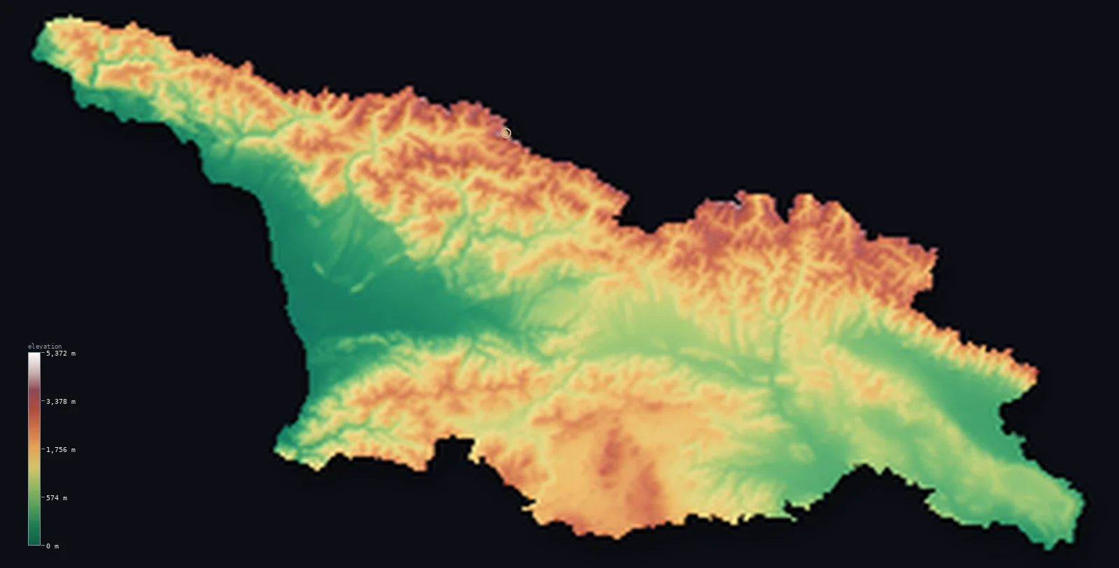
Georgia’s highest point is Shkhara at 17,037 ft (5,193 m); its lowest is Black Sea at 0 ft (0 m); the mean elevation is 4,045 ft (1,233 m).
Georgia is a mountainous country at the meeting of Europe and Asia, cradled between two great ranges of the Caucasus. Along its northern border rises the Greater Caucasus — a high, glaciated wall running the length of the country, holding Georgia's highest peaks, including Shkhara at 17,037 ft (5,193 m) on the Russian frontier. To the south runs the lower Lesser Caucasus. Between the two ranges lies the heart of Georgia: the central lowlands and valleys, opening westward to a humid Black Sea coast (the Colchis plain) and eastward to the drier plains of the Kura River. So the country is high at its edges and lower through its middle — though even the middle is far from flat, and half of Georgia lies above about 3,743 ft (1,141 m).
- Highest point📚
- 17,037 ft5,193 m
- Georgia's highest point is Shkhara at 17,037 ft (5,193 m), in the Greater Caucasus on the border with Russia — a high, glaciated summit in the Svaneti region, and one of the highest peaks in the whole Caucasus range. The Greater Caucasus forms Georgia's northern wall, a chain of ice-clad peaks (Shkhara, Janga, Kazbek) rising far above the valleys, several over 5,000 m, holding glaciers and permanent snow high above the subtropical lowlands to the south.
- Lowest point📚
- 0 ft0 m
- Georgia's lowest point is the Black Sea at sea level, along its western coast — the humid, subtropical Colchis plain, where the land meets the sea in marshes, river deltas, and the port of Poti. From this low western coast the land rises eastward and, above all, northward into the high Caucasus.
- Mean elevation⚙
- 4,045 ft1,233 m
- Computed from the GLO-30 model, Georgia's mean elevation is 4,045 ft (1,233 m) — a high figure, for Georgia is a genuinely mountainous country: the Greater Caucasus walls the north and the Lesser Caucasus rises in the south, with even the central valleys sitting well above the sea. Half the country lies above about 3,743 ft (1,141 m).
- Median elevation⚙
- 3,743 ft1,141 m
- Half of Georgia lies above about 3,743 ft (1,141 m) — a high figure that reflects a mountainous country: between the Greater Caucasus in the north and the Lesser Caucasus in the south, even the central lowlands and valleys sit well above sea level, and the high ranges lift much of the country far higher.
- Elevation range📚
- 17,037 ft5,193 m
- From the Black Sea coast to the summit of Shkhara at 5,193 m, Georgia's terrain climbs about 17,037 ft — from a humid subtropical shore up to one of the highest peaks in the Caucasus, across a country walled by high mountains north and south.
- Above 1,000 m (3,281 ft)⚙
- 55%
- About 55% of Georgia rises above 1,000 m (3,281 ft) — much of the country, for Georgia is mountainous: the high Greater Caucasus in the north, the Lesser Caucasus in the south, and the uplands between them. The central valleys and the Black Sea coast lie lower.
- Above 2,000 m (6,562 ft)⚙
- 20%
- Roughly 20% of Georgia stands above 2,000 m (6,562 ft) — the high country of the Greater Caucasus above all, its glaciated peaks and high valleys, with the higher parts of the Lesser Caucasus in the south.
- Official area📚
- 26,911 mi²69,700 km²
- Georgia covers about 26,911 sq mi (69,700 sq km) — a mountainous country at the meeting of Europe and Asia, walled by the high Greater Caucasus in the north (holding Shkhara) and the Lesser Caucasus in the south, with central lowlands between them opening to the Black Sea coast in the west and the Kura plains in the east.
- Forest cover📚
- 40.6%
- About 41% of Georgia is forested — lush temperate rainforest on the humid western slopes toward the Black Sea, mixed and beech forest through the Caucasus valleys, and drier woodland and steppe in the east, with alpine meadow and bare rock and ice on the high peaks.
Highest and lowest points
Georgia's highest point is Shkhara, 17,037 ft (5,193 m), a great glaciated peak in the Greater Caucasus on the border with Russia, in the highland region of Svaneti. It is one of the highest summits in the entire Caucasus — the range that many take as the divide between Europe and Asia — and stands among a cluster of peaks over 5,000 m along Georgia's northern wall, including Janga and, further east, the iconic cone of Kazbek. These are high, serious mountains: ice-clad, glacier-hung, rising far above the deep valleys of Svaneti with its medieval stone towers. The Greater Caucasus runs unbroken along the whole northern edge of Georgia; the Lesser Caucasus to the south is lower. So Georgia's roof is its northern border range, and Shkhara its highest point — a Caucasian giant high above the subtropical lowlands that lie, not far away, on the Black Sea.
source ↗Georgia's lowest point is the Black Sea at sea level, along its western coast — the Colchis plain, a humid, subtropical lowland of marshes, tea and citrus country, and river deltas, where the land meets the sea at ports like Poti and the resort of Batumi. This low, wet west is the exception in a mountainous country. From the coast the land rises inland in two directions. To the north stands the Greater Caucasus — a high, continuous, glaciated range along the Russian border, holding Georgia's highest peaks (Shkhara, Kazbek) and the remote highland region of Svaneti, with several summits over 5,000 m. To the south rises the Lesser Caucasus, lower but still mountainous, a volcanic upland toward the Armenian and Turkish borders. Between the two ranges lie the central lowlands, drained westward to the Black Sea and eastward by the Kura River toward the drier plains around the capital, Tbilisi. (Two regions, Abkhazia in the northwest and South Ossetia in the north, lie within Georgia's internationally recognized borders; the terrain shown follows those borders.)
source ↗Shkhara is a border summit: its peak lies just outside the generalized Georgia boundary, so the highest fully in-territory land pixel in the model is 16,716 ft (5,095 m). The headline figure above is the surveyed elevation of the recognised national high point.
Georgia at a glance
Georgia's highest point, Shkhara (5,193 m), is one of the highest peaks in the entire Caucasus - a glaciated summit on the Russian border in the highland region of Svaneti.
source ↗Georgia sits at the meeting of Europe and Asia, walled by two ranges - the high Greater Caucasus in the north and the Lesser Caucasus in the south - with lowlands between.
source ↗Georgia's western coast is humid and subtropical - the Colchis plain, tea and citrus country, where the high Caucasus stand not far from a warm Black Sea shore.
source ↗The Greater Caucasus along Georgia's northern border holds several peaks over 5,000 m - Shkhara, Janga, and the iconic cone of Kazbek - a high, glaciated mountain wall.
source ↗The remote highland region of Svaneti, high in the Georgian Caucasus, is famous for its medieval defensive stone towers, set beneath the highest peaks.
source ↗Georgia is genuinely mountainous - about half the country lies above 1,000 m, high at both its northern and southern edges.
source ↗
Elevation profile of Georgia
The largest share of land, 24%, falls in the 0–500 m band, and 76% of the territory lies above 500 m (1,640 ft).
- below 500 m (1,640 ft)24%
- 500–1,000 m21%
- 1,000–2,000 m35%
- above 2,000 m (6,562 ft)20%
Highest peaks of Georgia
| Peak | Elevation | Range | Note |
|---|---|---|---|
| Shkhara↗ | 17,037 ft5,193 m | Greater Caucasus (Russia border) | Highest point of Georgia, on the Russia border, the eastern anchor of the Bezengi Wall. |
| Janga (Jangi-Tau)↗ | 16,598 ft5,059 m | Greater Caucasus (Russia border) | A high glaciated peak of the Bezengi Wall, on the Russia border west of Shkhara. |
| Kazbek (Mkinvartsveri)↗ | 16,512 ft5,033 m | Greater Caucasus (northeast) | An extinct volcano in the northeastern Greater Caucasus, near the Russian border and the Georgian Military Road. |
| Tetnuldi↗ | 15,938 ft4,858 m | Greater Caucasus (Svaneti) | A glaciated peak of the Svaneti highlands, near Shkhara. |
| Ushba↗ | 15,453 ft4,710 m | Greater Caucasus (Svaneti) | A striking twin-horned peak of Svaneti, one of the most difficult climbs in the Caucasus. |
Georgia: the Greater Caucasus, the central lowlands, and the Lesser Caucasus
The Greater Caucasus — the north
Along Georgia's northern border rises the Greater Caucasus — a high, continuous, glaciated range holding the country's highest peaks (Shkhara, Kazbek, several over 5,000 m) and the remote highland regions of Svaneti and Khevsureti. Georgia's high, ice-clad northern wall.
The central lowlands — Colchis and the Kura
Between the two ranges lie Georgia's central lowlands — the humid Colchis plain opening to the Black Sea in the west, and the drier Kura River plains around Tbilisi in the east. The lower, populous heart of the country, though still above the sea.
The Lesser Caucasus — the south
In the south rises the Lesser Caucasus — a lower but still mountainous volcanic upland toward the Armenian and Turkish borders, with high plateaus and peaks. Georgia's southern highland edge.
How to read this map
Color shows elevation; the raised relief shows real terrain. On this map Georgia reads as a country high at its edges — the browns and whites of the Greater Caucasus standing along the entire northern border (highest at Shkhara, with the glaciated peaks over 5,000 m), the Lesser Caucasus rising in the south, and the lower green of the central lowlands between them, dropping to the Black Sea coast in the far west.
The 3D relief is the actual GLO-30 elevation data, exaggerated vertically so the high ranges and the lower center both show; the ×N relief slider controls how much. Tap anywhere to read that point's exact elevation.
City elevations in Georgia
Georgia's cities lie mostly in the central lowlands and valleys — Tbilisi, the capital, in the Kura valley of the east, with Kutaisi in the western lowlands, Batumi on the Black Sea coast, and Gori in the central valley. Most of the population lives in the lower center, below the high Caucasus.
| City | Population | Elevation |
|---|---|---|
| Tbilisicapitalthe capital, in the Kura River valley of eastern Georgia ↗ | 1,049,498 | 1,647 ft502 m |
| Batumion the Black Sea coast, in the Adjara region ↗ | 186,949 | 16 ft5 m |
| Kutaisiin the western Colchis lowlands ↗ | 135,201 | 495 ft151 m |
| Sokhumion the Black Sea coast in the northwest ↗ | 65,439 | 82 ft25 m |
| Goriin the central Kura valley ↗ | 41,933 | 1,969 ft600 m |
| Potia Black Sea port on the Colchis coast ↗ | 41,175 | 13 ft4 m |
| Zugdidiin the northwestern Colchis lowlands ↗ | 40,067 | 341 ft104 m |
| Khashuriin the central valley between the ranges ↗ | 23,949 | 2,454 ft748 m |
| Telaviin the eastern Kakheti wine country ↗ | 19,875 | 2,297 ft700 m |
| Akhaltsikhein the south, toward the Lesser Caucasus and the Turkish border ↗ | 17,445 | 3,235 ft986 m |
Elevation sampled at each city centre from the Copernicus GLO-30 model. Cities and population from GeoNames (CC-BY 4.0).
Georgia in comparison
Georgia's terrain rises 17,037 ft (5,193 m) from sea level to Shkhara — about 59% of the height of Mount Everest, the world's highest point at 29,032 ft (8,849 m).
- Armenia's mean elevation is 6,070 ft — 2,024 ft higher; its high point, Mount Aragats, reaches 13,419 ft (4,090 m), 3,619 ft below. Armenia elevation map →
- Azerbaijan's mean elevation is 2,169 ft — 1,877 ft lower; its high point, Mount Bazardüzü, reaches 14,652 ft (4,466 m), 2,385 ft below. Azerbaijan elevation map →
- Turkey's mean elevation is 3,737 ft — 308 ft lower; its high point, Mount Ararat (Agri Dagi), reaches 16,854 ft (5,137 m), 184 ft below. Turkey elevation map →
Frequently asked questions
What is the highest point in Georgia?
- Shkhara, 17,037 ft (5,193 m), in the Greater Caucasus on the Russian border - one of the highest peaks in the entire Caucasus range.
What is the lowest point in Georgia?
- The Black Sea at sea level, along the humid subtropical western coast (the Colchis plain).
What is the average elevation of Georgia?
- Computed from the Copernicus GLO-30 model, the area-weighted mean is 4,045 ft (1,233 m) - high, because Georgia is genuinely mountainous, walled by the Greater Caucasus in the north and the Lesser Caucasus in the south. Half the country lies above about 3,743 ft (1,141 m).
Is Georgia mountainous?
- Yes - very. The high Greater Caucasus walls the north (holding Shkhara, 5,193 m), the Lesser Caucasus rises in the south, and even the central lowlands sit well above the sea. About half the country is above 1,000 m.
Where do Europe and Asia meet in Georgia?
- The Greater Caucasus along Georgia's northern border is often taken as the dividing line between Europe and Asia - placing Georgia at the very meeting of the two continents.
Is this a topographic, relief, contour, or elevation map of Georgia?
- They describe the same thing - terrain height. This page renders the country's actual elevation surface in interactive 3D and reports the statistics computed from it.
About this map
The terrain is rendered from the Copernicus GLO-30 digital elevation model (ESA), masked to the GEO-ADM0 boundary from geoBoundaries (gbOpen). Elevation statistics are computed directly from the model; peak names and researched facts are sourced and cited. See the methodology for the full pipeline.
Our area-weighted mean, computed from the Copernicus GLO-30 model, is 4,045 ft (1,233 m); the figure commonly cited elsewhere is 4,698 ft (1,432 m) (CIA World Factbook). Georgia is genuinely mountainous, high at both its northern and southern edges. The Greater Caucasus walls the north — a chain of ice-clad peaks over 5,000 m, holding Shkhara — and the Lesser Caucasus rises in the south; between them the central lowlands and valleys, though lower, still sit well above the sea. So the country's high, and half of it lies above about 3,743 ft (1,141 m). Only the Black Sea coast in the far west and the river plains drop toward sea level; the rest is upland and mountain.
Surveyed national figures: official area · forest cover · high point.
Rendered from Copernicus GLO-30 (ESA, 2021 release), with NASADEM (NASA/USGS) over the Armenia/Azerbaijan coverage gap, boundaries from geoBoundaries. Generated 2026-06-21.
Bordering countries · 4
Georgia shares a land border with these countries — open any one to compare its terrain and highest point.