Azerbaijan Elevation Map — Topographic & 3D Terrain
Explore the terrain of Azerbaijan in interactive 3D, built from Copernicus GLO-30 satellite elevation data — a country of low Caspian lowlands and high Caucasus mountains, dipping below sea level at its coast. Drag to rotate, scroll to zoom, and tap any point to read its elevation.
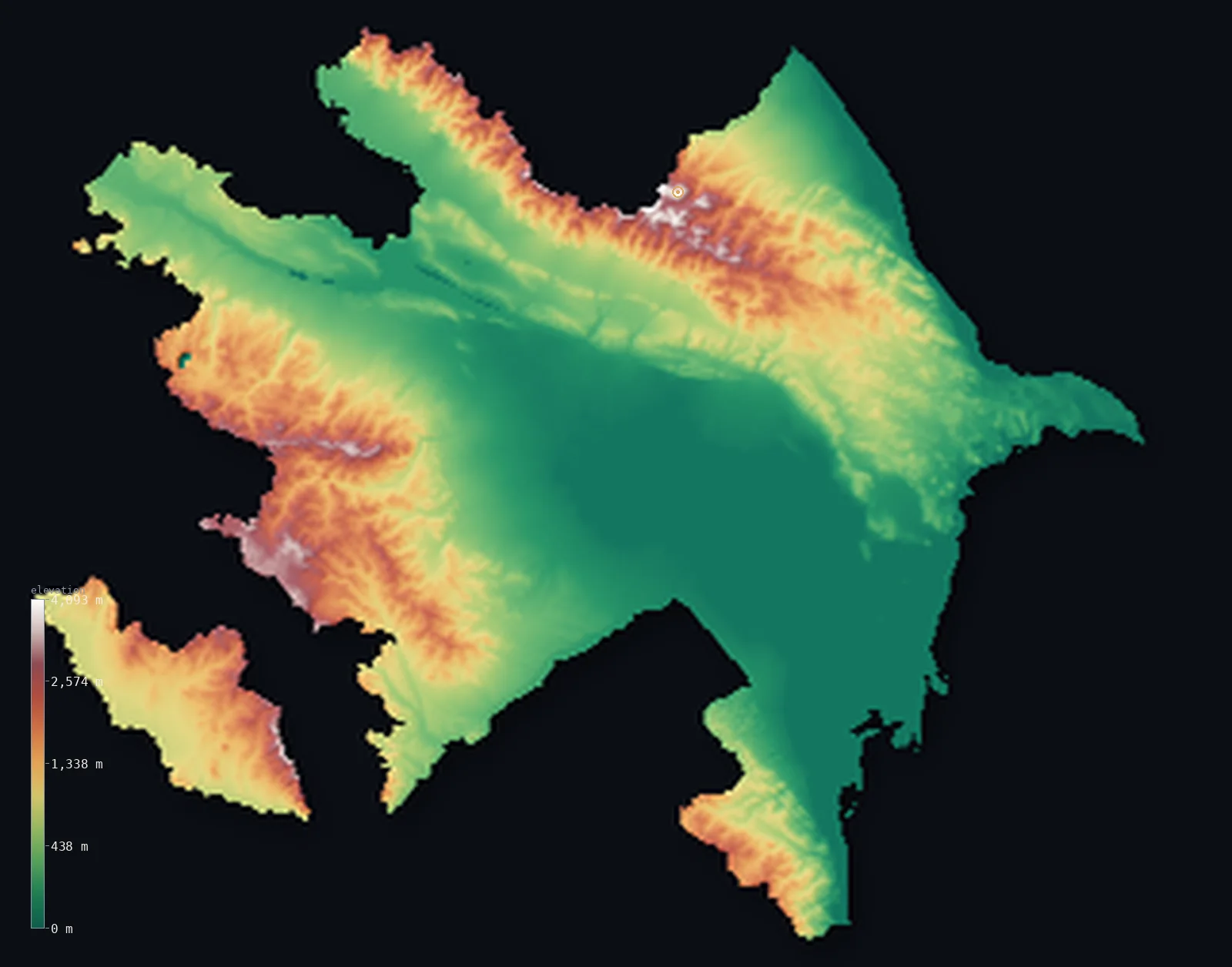
Azerbaijan’s highest point is Mount Bazardüzü at 14,652 ft (4,466 m); its lowest is Caspian Sea at −92 ft (−28 m); the mean elevation is 2,169 ft (661 m).
Azerbaijan is a country of two very different terrains, meeting on the western shore of the Caspian Sea. Much of it is low: the broad central lowlands of the Kura River, and a Caspian coast that dips below the level of the world's oceans — for the Caspian Sea itself lies about 92 ft (28 m) below sea level, and its shore is the lowest land in Azerbaijan. But along the north, on the border with Russia, rises the Greater Caucasus, holding the country's highest peak, Bazardüzü, at 14,652 ft (4,466 m). So the land runs from below-sea coast up to high glaciated mountains. Overall it is a low-lying country — half of Azerbaijan lies below about 1,148 ft (350 m) — with its heights gathered along its northern and western edges.
- Highest point📚
- 14,652 ft4,466 m
- Azerbaijan's highest point is Bazardüzü at 14,652 ft (4,466 m), in the Greater Caucasus on the border with Russia — a high, glaciated peak at the northeastern end of the great range, the roof of Azerbaijan standing far above the Caspian lowlands to the south. The Greater Caucasus forms the country's northern wall, a chain of high peaks (Bazardüzü, Shahdag) rising above the plains, several near or over 4,000 m, with snow and small glaciers on their summits.
- Lowest point📚
- −92 ft−28 m
- Azerbaijan's lowest point is the shore of the Caspian Sea, at about 92 ft (28 m) below sea level — for the Caspian, the world's largest inland body of water, lies well below the level of the oceans, and its Azerbaijani coast is the lowest land in the country. This makes Azerbaijan one of the countries whose lowest ground is a genuine depression, below the global sea. From this below-sea coast the land rises inland across the Kura lowlands to the mountains.
- Mean elevation⚙
- 2,169 ft661 m
- Computed from the GLO-30 model, Azerbaijan's mean elevation is 2,169 ft (661 m) — but this is lifted by the high Greater Caucasus, and the typical point is far lower: half the country lies below about 1,148 ft (350 m), in the broad Kura River lowlands and along the below-sea Caspian coast. Azerbaijan is a low-lying country with a high mountain fringe.
- Median elevation⚙
- 1,148 ft350 m
- Half of Azerbaijan lies below about 1,148 ft (350 m) — much lower than the mean, because the country is mostly low: the broad Kura River lowlands fill the center, and the Caspian coast dips below sea level, while only the Greater Caucasus in the north and the uplands in the west rise high, lifting the average above the typical low point.
- Elevation range📚
- 14,744 ft4,494 m
- From the below-sea Caspian coast (about 28 m below sea level) to the summit of Bazardüzü at 4,466 m, Azerbaijan's terrain spans nearly 15,000 ft — one of the great ranges of any country in the region, from a genuine depression below the world's oceans up to the high glaciated Caucasus.
- Above 1,000 m (3,281 ft)⚙
- 26%
- About 26% of Azerbaijan rises above 1,000 m (3,281 ft) — chiefly the Greater Caucasus in the north and the uplands and the Lesser Caucasus in the west. Most of the country — the Kura lowlands and the below-sea Caspian coast — lies well below.
- Above 2,000 m (6,562 ft)⚙
- 8%
- About 8% of Azerbaijan stands above 2,000 m (6,562 ft) — only the high Greater Caucasus in the north, rising to Bazardüzü and Shahdag, and the higher Lesser Caucasus in the west. The low majority of the country lies far below.
- Official area📚
- 33,436 mi²86,600 km²
- Azerbaijan covers about 33,436 sq mi (86,600 sq km) — a country on the western Caspian shore, of broad low Kura River lowlands and a below-sea Caspian coast, rising to the high Greater Caucasus in the north (holding Bazardüzü) and uplands in the west, with the exclave of Nakhchivan set apart to the southwest.
- Forest cover📚
- 14%
- About 14% of Azerbaijan is forested — a fairly lightly wooded country, with forest on the wetter mountain slopes of the Greater and Lesser Caucasus, and much of the central Kura lowlands under dry steppe, semi-desert, and irrigated farmland.
Highest and lowest points
Azerbaijan's highest point is Bazardüzü, 14,652 ft (4,466 m), a high glaciated peak in the Greater Caucasus on the border with Russia, at the northeastern end of the great range. It rises far above the Caspian lowlands to the south, snow-capped, with small glaciers near its summit — the roof of a country whose lowest ground, on the Caspian shore, actually dips below the level of the world's oceans. The Greater Caucasus walls the north of Azerbaijan with a line of high peaks — Bazardüzü, Shahdag, and others near or above 4,000 m — and Bazardüzü is their highest on the Azerbaijani side. To the west, the Lesser Caucasus rises lower. So Azerbaijan's summit is a Caucasian giant on its northern border, high above the low, warm, below-sea Caspian coast where most of the country's life is gathered.
source ↗Azerbaijan's lowest point is the shore of the Caspian Sea, about 92 ft (28 m) below sea level — for the Caspian, the largest inland body of water on Earth, lies well below the level of the oceans, and Azerbaijan's coast along it is the lowest land in the country. Much of Azerbaijan is low: the broad central lowlands of the Kura River, which gathers the country's waters and flows to the Caspian, are wide, flat, and low, shading into dry steppe and semi-desert. But the country is walled and fringed by mountains. Along the northern border with Russia rises the Greater Caucasus, high and glaciated, holding Bazardüzü (4,466 m, the highest point) and Shahdag. In the west rise the Lesser Caucasus and the uplands toward the Armenian border. Set apart to the southwest, beyond Armenian territory, lies the mountainous exclave of Nakhchivan. On the Caspian shore itself stands the capital, Baku, on the Abşeron Peninsula, famous for its oil. So Azerbaijan runs from a genuine below-sea depression on the Caspian up to the high Caucasus — low through the middle, high at the rim. (Terrain is shown following Azerbaijan's internationally recognized borders.)
source ↗Azerbaijan at a glance
Azerbaijan's Caspian coast lies about 28 m below sea level - the Caspian Sea, the world's largest inland body of water, sits well below the level of the oceans, making the shore the lowest land in the country.
source ↗Azerbaijan runs from a below-sea Caspian coast up to the high Greater Caucasus - its highest point, Bazardüzü (4,466 m), on the Russian border.
source ↗Though it rises to high mountains, Azerbaijan is a mostly low-lying country - half of it lies below about 350 m, in the broad Kura River lowlands and the Caspian coast.
source ↗The broad lowlands of the Kura River fill central Azerbaijan - flat, low country of steppe, semi-desert, and irrigated farmland, draining to the Caspian.
source ↗Azerbaijan's capital, Baku, sits on the Caspian shore below sea level - long famous for the oil fields of the Abşeron Peninsula.
source ↗The mountainous exclave of Nakhchivan is part of Azerbaijan but set apart to the southwest, separated from the rest of the country by Armenian territory.
source ↗
Elevation profile of Azerbaijan
The largest share of land, 41%, falls in the 0–500 m band, and 58% of the territory lies below 500 m (1,640 ft).
- below 500 m (1,640 ft)58%
- 500–1,000 m16%
- 1,000–2,000 m18%
- above 2,000 m (6,562 ft)8%
Highest peaks of Azerbaijan
| Peak | Elevation | Range | Note |
|---|---|---|---|
| Mount Bazardüzü↗ | 14,652 ft4,466 m | Greater Caucasus | Highest point of Azerbaijan, on the Russia (Dagestan) border; holds the largest glaciers in the eastern Caucasus. |
| Shahdag↗ | 13,921 ft4,243 m | Greater Caucasus | Second-highest peak in Azerbaijan, near the Russian border in Qusar district; caves at its base show 9,000 years of human use. |
| Tufandag↗ | 13,770 ft4,197 m | Greater Caucasus | Third-highest in Azerbaijan, above the resort town of Gabala in the Greater Caucasus. |
| Mount Gamish↗ | 12,218 ft3,724 m | Lesser Caucasus (Murovdag) | Highest peak of the Murovdag ridge and of the Lesser Caucasus within Azerbaijan, in the west. |
| Kapaz↗ | 10,059 ft3,066 m | Lesser Caucasus | A striking peak above Lake Göygöl, which was formed when a 1139 earthquake dammed a river. |
| Talysh Mountains high point (Kömürköy)↗ | 8,127 ft2,477 m | Talysh Mountains | Highest ground of the Talysh range in the humid subtropical southeast, on the Iranian border. |
Azerbaijan: the Kura lowlands and Caspian coast, the Greater Caucasus, and the western highlands
The Kura lowlands and Caspian coast
The center of Azerbaijan is broad, low country — the lowlands of the Kura River, flat and dry, shading to the Caspian coast, which dips below the level of the oceans (the lowest land in the country). The low, populous body of the nation.
The Greater Caucasus — the north
Along the northern border with Russia rises the Greater Caucasus — a high, glaciated range holding Bazardüzü (the high point) and Shahdag, several peaks near or over 4,000 m. Azerbaijan's high northern wall.
The Lesser Caucasus and Nakhchivan — the west
In the west rise the Lesser Caucasus and uplands toward the Armenian border, and set apart to the southwest lies the mountainous exclave of Nakhchivan. The country's western and detached highlands.
How to read this map
Color shows elevation; the raised relief shows real terrain. On this map Azerbaijan reads as a low country rimmed by mountains — the broad low green (and below-sea blue at the coast) of the Kura lowlands and the Caspian shore filling the center and east, rising to the browns and whites of the Greater Caucasus along the northern border (highest at Bazardüzü) and the Lesser Caucasus in the west. The Caspian coast dips below sea level, shown in the below-sea band.
The 3D relief is the actual GLO-30 elevation data, exaggerated vertically so the high Caucasus and the low center both show; the ×N relief slider controls how much. Tap anywhere to read that point's exact elevation.
City elevations in Azerbaijan
Azerbaijan's cities cluster on the Caspian coast and in the Kura lowlands — Baku, the capital, on the Caspian below sea level, with Ganja in the west toward the Lesser Caucasus, Sheki in the north below the Greater Caucasus, and Naxçıvan in the detached southwestern exclave. Most of the population lives low, in the lowlands and along the shore.
| City | Population | Elevation |
|---|---|---|
| Bakucapitalthe capital, on the Caspian coast below sea level, on the Abşeron Peninsula ↗ | 2,351,300 | −16 ft−5 m |
| Ganjain the west, toward the Lesser Caucasus ↗ | 335,600 | 1,358 ft414 m |
| Lankaranon the southern Caspian coast, near the Iranian border ↗ | 240,300 | −62 ft−19 m |
| Yevlakhin the central Kura lowlands ↗ | 127,400 | 56 ft17 m |
| Naxçıvanthe main town of the Nakhchivan exclave in the southwest ↗ | 97,200 | 2,890 ft881 m |
| Saatlı | 87,000 | −26 ft−8 m |
| Şirvanon the Kura in the central lowlands ↗ | 70,220 | −36 ft−11 m |
| Shekiin the north, below the Greater Caucasus ↗ | 68,400 | 1,634 ft498 m |
| Göyçayin the central Kura lowlands ↗ | 42,500 | 374 ft114 m |
| Aghjabadiin the Kura-Aras lowlands of the centre ↗ | 41,200 | 43 ft13 m |
Elevation sampled at each city centre from the Copernicus GLO-30 model. Cities and population from GeoNames (CC-BY 4.0).
Azerbaijan in comparison
Azerbaijan's terrain rises 14,744 ft (4,494 m) from Caspian Sea, 92 ft (28 m) below sea level to Mount Bazardüzü — about 51% of the height of Mount Everest, the world's highest point at 29,032 ft (8,849 m).
- Georgia's mean elevation is 4,045 ft — 1,877 ft higher; its high point, Shkhara, reaches 17,037 ft (5,193 m), 2,385 ft above. Georgia elevation map →
- Armenia's mean elevation is 6,070 ft — 3,901 ft higher; its high point, Mount Aragats, reaches 13,419 ft (4,090 m), 1,234 ft below. Armenia elevation map →
- Switzerland's mean elevation is 4,301 ft — 2,133 ft higher; its high point, Dufourspitze (Monte Rosa), reaches 15,203 ft (4,634 m), 551 ft above. Switzerland elevation map →
Frequently asked questions
What is the highest point in Azerbaijan?
- Bazardüzü, 14,652 ft (4,466 m), in the Greater Caucasus on the Russian border - a high glaciated peak, the roof of the country above the Caspian lowlands.
What is the lowest point in Azerbaijan?
- The Caspian Sea shore, about 92 ft (28 m) below sea level - the Caspian lies below the level of the world's oceans, making its coast the lowest land in Azerbaijan.
What is the average elevation of Azerbaijan?
- Computed from the Copernicus GLO-30 model, the area-weighted mean is 2,169 ft (661 m) - lifted by the high Greater Caucasus, though half the country lies below about 1,148 ft (350 m), in the Kura lowlands and the below-sea Caspian coast.
Is Azerbaijan below sea level?
- Part of it - the Caspian coast lies about 28 m below sea level, since the Caspian Sea sits below the level of the oceans. Much of central Azerbaijan (the Kura lowlands) is low, though the country rises to the high Caucasus in the north.
What is the Caspian Sea's elevation?
- The Caspian Sea lies about 28 m below global sea level - it is the world's largest inland body of water, with no outlet to the ocean, and Azerbaijan's coast along it is the country's lowest land.
Is this a topographic, relief, contour, or elevation map of Azerbaijan?
- They describe the same thing - terrain height. This page renders the country's actual elevation surface in interactive 3D and reports the statistics computed from it.
About this map
The terrain is rendered from the Copernicus GLO-30 digital elevation model (ESA), masked to the AZE-ADM0 boundary from geoBoundaries (gbOpen). Elevation statistics are computed directly from the model; peak names and researched facts are sourced and cited. See the methodology for the full pipeline.
This map renders 84,705 km² across 2050 landmasses of Azerbaijan. 361 smaller outlying parts — 5 km² in total — lie beyond the area shown here. Area statistics above count the full territory.
Our area-weighted mean, computed from the Copernicus GLO-30 model, is 2,169 ft (661 m); the figure commonly cited elsewhere is 1,260 ft (384 m) (CIA World Factbook). Azerbaijan is a low-lying country with its heights along the edges. The broad lowlands of the Kura River fill the center, and the Caspian coast actually dips below the level of the world's oceans — the Caspian Sea lies about 28 m below sea level, and its shore is the lowest land in the country. These low lands hold most of Azerbaijan, so half of it lies below about 1,148 ft (350 m). Only along the northern border does the Greater Caucasus rise high — to Bazardüzü, 4,466 m — with the Lesser Caucasus and uplands in the west; these mountains lift the average elevation well above the typical point, but they are the fringe, not the body, of a low country on the Caspian shore. (The mean here is computed directly from the GLO-30 surface, and runs above a lower average sometimes cited elsewhere.)
Surveyed national figures: official area · forest cover · high point.
Rendered from Copernicus GLO-30 (ESA, 2021 release), with NASADEM (NASA/USGS) over the Armenia/Azerbaijan coverage gap, boundaries from geoBoundaries. Generated 2026-07-18.
Bordering countries · 5
Azerbaijan shares a land border with these countries — open any one to compare its terrain and highest point.