Iran Elevation Map — Topographic & 3D Terrain
Explore the terrain of Iran in interactive 3D, built from Copernicus GLO-30 satellite elevation data — a high central plateau ringed by mountains, with deserts inside and a volcano above. Drag to rotate, scroll to zoom, and tap any point to read its elevation.
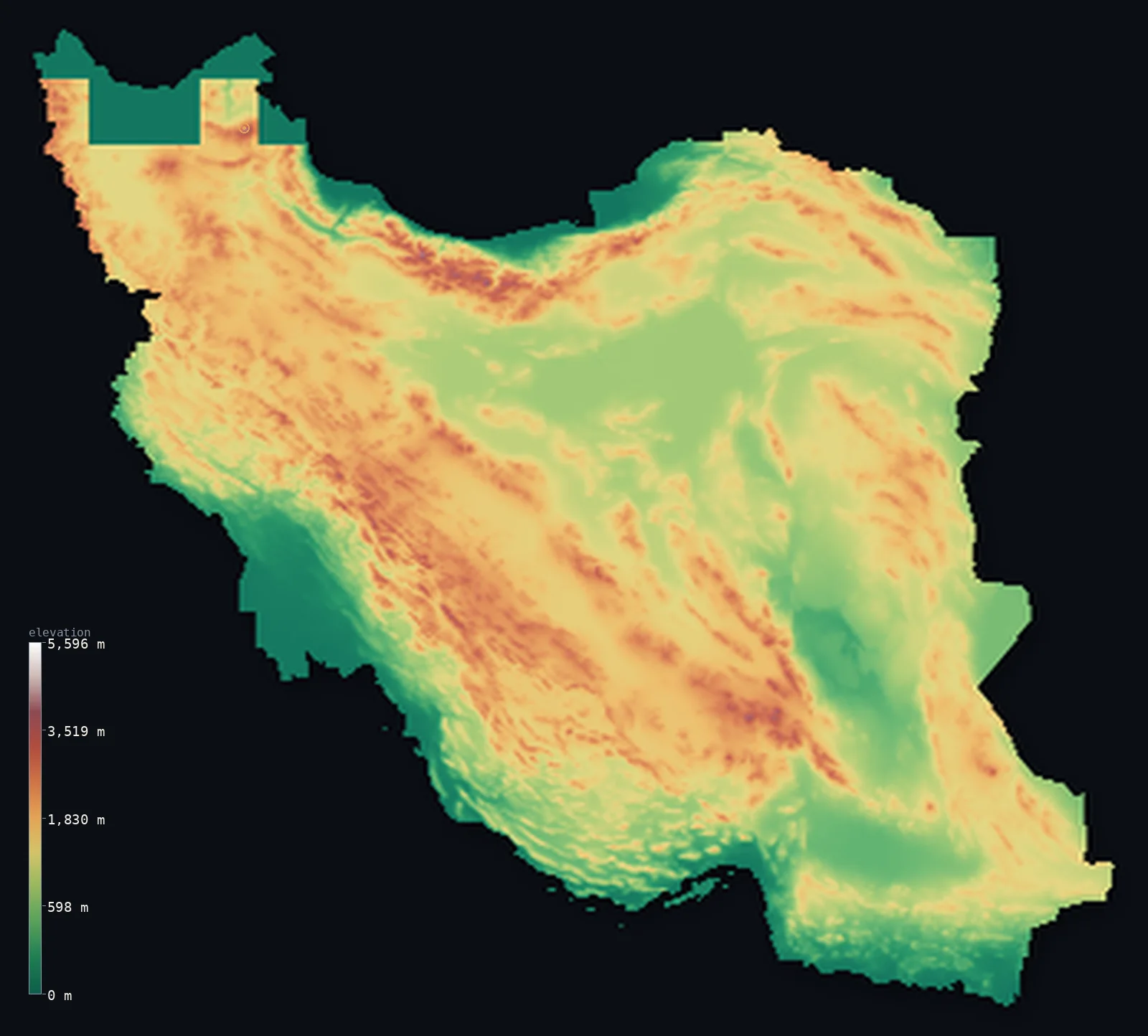
Iran’s highest point is Mount Damavand at 18,406 ft (5,610 m); its lowest is Caspian Sea at −92 ft (−28 m); the mean elevation is 4,101 ft (1,250 m).
Iran is a high plateau held inside a ring of mountains. The Zagros run down the west in long parallel folds, the Elburz curve along the north above the Caspian, and between and within them lies the Iranian plateau — high, dry, and cut by two great deserts, the Dasht-e Kavir and the Dasht-e Lut. About 61% of the country stands above 3,281 ft (1,000 m). Above the Elburz rises Mount Damavand, a dormant volcano reaching 18,406 ft (5,610 m) — the highest peak in the Middle East and the highest volcano in Asia.
- Highest point📚
- 18,406 ft5,610 m
- Iran's highest point is Mount Damavand at 18,406 ft (5,610 m), a dormant volcano in the Elburz range north of Tehran — the highest peak in the Middle East and the highest volcano in Asia, a snow-capped, symmetrical cone that stands far above the ranges around it. (Published heights vary from about 5,610 to 5,671 m; the figure used here is 5,610 m.)
- Lowest point📚
- −92 ft−28 m
- Iran's lowest point is the Caspian Sea coast in the north, at about 92 ft (28 m) below sea level — the shore of the world's largest inland body of water, which lies well beneath the level of the ocean. Iran's southern coasts, on the Persian Gulf and Gulf of Oman, are at sea level.
- Mean elevation⚙
- 4,101 ft1,250 m
- Computed from the GLO-30 model, Iran's mean elevation is 4,101 ft (1,250 m) — a high average, and an accurate one: Iran is fundamentally a high country, a raised plateau ringed and crossed by mountains, with only its coastal margins lying low.
- Median elevation⚙
- 4,009 ft1,222 m
- Half of Iran lies above 4,009 ft (1,222 m) — a high median that captures the plateau: the typical point in the country is well over a kilometre up, on the elevated tableland that fills the interior between the mountain rims.
- Elevation range📚
- 18,497 ft5,638 m
- From the Caspian shore below sea level to the summit of Damavand, Iran spans about 18,500 ft — from a coast beneath the ocean's level to a volcano that tops every other peak in the Middle East, most of the height held in the Zagros and Elburz rims.
- Above 1,000 m (3,281 ft)⚙
- 61%
- About 61% of Iran rises above 1,000 m (3,281 ft) — the great plateau and its mountain rings, the Zagros in the west and the Elburz in the north. Only the Caspian lowland and the southern coastal plains fall below that line.
- Above 2,000 m (6,562 ft)⚙
- 15%
- Roughly 15% of Iran stands above 2,000 m (6,562 ft) — the higher folds of the Zagros, the Elburz crest, and the raised eastern plateau, cold high country above the deserts of the interior basins.
- Official area📚
- 636,371 mi²1,648,195 km²
- Iran covers about 636,000 sq mi (1,648,195 sq km) — a large country built around a central plateau, walled by the Zagros to the west and the Elburz to the north, and bordered by the Caspian, the Persian Gulf, and the Gulf of Oman.
- Forest cover📚
- 6.6%
- About 6.6% of Iran is forested — most notably the Hyrcanian forests on the wet Caspian slopes of the Elburz, an ancient temperate woodland; the plateau and deserts of the interior carry little.
Highest and lowest points
Iran's highest point is Mount Damavand, 18,406 ft (5,610 m), a dormant volcano in the Elburz range about 65 km northeast of Tehran — the highest mountain in the Middle East and the highest volcano in Asia. It is a near-perfect cone, snow-capped year-round, standing well above the surrounding Elburz peaks and visible from Tehran and the Caspian alike. A powerful presence in Persian myth and literature, it is also geologically young, with fumaroles near its summit. Published elevations range from about 5,610 to 5,671 m; the figure used here is 5,610 m.
source ↗Iran's lowest point is the Caspian Sea coast in the north, about 92 ft (28 m) below sea level. The Caspian is the largest inland body of water on Earth, and its surface sits well below the ocean's — so Iran's northern shore, a narrow, humid, densely settled strip backed immediately by the steep Elburz, lies beneath sea level. It is a sharp contrast: within a short horizontal distance the land climbs from below the sea to the 5,610 m summit of Damavand. Iran's southern coasts, on the Persian Gulf and the Gulf of Oman, are at ordinary sea level.
source ↗Iran at a glance
Mount Damavand (5,610 m), a dormant volcano in the Elburz, is the highest peak in the Middle East and the highest volcano in Asia.
source ↗Iran is built around a high central plateau ringed by mountains — the Zagros down the west, the Elburz along the north — with about 61% of the country above 1,000 m.
source ↗The Iranian plateau holds two great deserts, the Dasht-e Kavir (a salt desert) and the Dasht-e Lut, one of the hottest places on Earth by recorded surface temperature.
source ↗The Caspian coast of northern Iran lies about 28 m below sea level, backed by the steep Elburz and cloaked in the ancient Hyrcanian forest — a green, humid strip unlike the arid interior.
source ↗The Zagros Mountains run for some 1,600 km down western Iran in long parallel folds, formed where the Arabian plate collides with Iran.
source ↗Within a short distance the land rises from the Caspian shore, below sea level, to the 5,610 m summit of Damavand — one of the steepest elevation gradients in the region.
source ↗
Elevation profile of Iran
The largest share of land, 25%, falls in the 1,000–1,500 m band, and 85% of the territory lies above 500 m (1,640 ft).
- below 500 m (1,640 ft)15%
- 500–1,000 m24%
- 1,000–2,000 m47%
- above 2,000 m (6,562 ft)15%
Highest peaks of Iran
| Peak | Elevation | Range | Note |
|---|---|---|---|
| Mount Damavand↗ | 18,406 ft5,610 m | Alborz (north) | Highest point of Iran and the Middle East, a dormant stratovolcano in the Alborz near the Caspian. |
| Alam-Kuh↗ | 15,912 ft4,850 m | Alborz (Takht-e Suleyman massif) | The second-highest peak in Iran, in the Takht-e Suleyman massif of the central Alborz, known for its sheer rock wall. |
| Sabalan↗ | 15,784 ft4,811 m | Northwestern Iran | A massive dormant volcano in the northwest, with a crater lake near its summit. |
| Hazaran↗ | 14,767 ft4,501 m | Southeastern highlands (Kerman) | The high point of the mountains of Kerman province in the southeast. |
| Dena (Qash Mastan)↗ | 14,465 ft4,409 m | Zagros (southwest) | The highest summit of the Dena massif, among the loftiest in the long Zagros chain. |
The Zagros, the Elburz, and the plateau between
The Zagros Mountains (west)
Long parallel ridges of folded rock running northwest to southeast down the whole western side of the country, from the Turkish border toward the Persian Gulf. Formed by the collision of the Arabian and Iranian plates, the Zagros hold much of Iran's high ground and shelter the plateau behind them.
The Elburz and the Caspian coast (north)
Along the north, the Elburz range curves in a narrow, very high wall between the plateau and the Caspian Sea — carrying Damavand, the country's high point. On its far side drops the Caspian lowland, below sea level, humid and forested: the sharpest contrast in the country.
The central plateau and deserts
Enclosed by the mountain rims lies the Iranian plateau — high, arid tableland holding the great interior deserts, the salt Dasht-e Kavir and the Dasht-e Lut. The plateau's basins have no outlet to the sea, and the deserts are among the driest and hottest ground on Earth.
The coastal lowlands (south)
Along the Persian Gulf and the Gulf of Oman in the south lies a hot, low coastal plain — the Khuzestan lowland in the southwest, continuous with the plains of Iraq, and a narrower strip eastward — the country's low southern edge below the rising Zagros.
How to read this map
Color shows elevation; the raised relief shows real terrain. On this map Iran reads as a high, rimmed bowl — brown-and-white mountains ringing the country down the west (the Zagros) and along the north (the Elburz), with the single white cone of Damavand above Tehran, enclosing a high plateau whose interior deserts read as smoother ground, and low coastal strips north and south.
The 3D relief is the actual GLO-30 elevation data, exaggerated vertically so the mountain rims and the plateau both show; the ×N relief slider controls how much. Tap anywhere to read that point's exact elevation.
City elevations in Iran
Iran's cities sit mostly on the plateau and along the mountain feet — Tehran against the Elburz in the north, Mashhad, Isfahan, Shiraz, and Tabriz across the high interior and the Zagros — with Ahvaz low on the southern Khuzestan plain. Most stand well above 1,000 m.
| City | Population | Elevation |
|---|---|---|
| Tehrancapitalthe capital, on the plateau at the foot of the Elburz, beneath Mount Damavand ↗ | 7,153,309 | 3,858 ft1,176 m |
| Mashhadin the northeast toward the Afghan border ↗ | 2,307,177 | 3,222 ft982 m |
| Isfahanon the central plateau, on the Zayandeh river ↗ | 1,547,164 | 5,171 ft1,576 m |
| Tabriz | 1,424,641 | — |
| Shiraz | 1,249,942 | 5,049 ft1,539 m |
| Qom | 900,000 | 3,061 ft933 m |
| Ahvazlow on the southern Khuzestan plain ↗ | 841,145 | 72 ft22 m |
| Kermanshah | 621,100 | 4,567 ft1,392 m |
| Rasht | 594,590 | 13 ft4 m |
| Kerman | 577,514 | 5,778 ft1,761 m |
Elevation sampled at each city centre from the Copernicus GLO-30 model. Cities and population from GeoNames (CC-BY 4.0).
Iran in comparison
Iran's terrain rises 18,497 ft (5,638 m) from Caspian Sea, 92 ft (28 m) below sea level to Mount Damavand — about 64% of the height of Mount Everest, the world's highest point at 29,032 ft (8,849 m).
- Turkey's mean elevation is 3,737 ft — 364 ft lower; its high point, Mount Ararat (Agri Dagi), reaches 16,854 ft (5,137 m), 1,552 ft below. Turkey elevation map →
- Iraq's mean elevation is 974 ft — 3,127 ft lower; its high point, Cheekha Dar, reaches 11,847 ft (3,611 m), 6,558 ft below. Iraq elevation map →
- Afghanistan's mean elevation is 5,906 ft — 1,804 ft higher; its high point, Noshaq, reaches 24,580 ft (7,492 m), 6,175 ft above. Afghanistan elevation map →
Frequently asked questions
What is the highest point in Iran?
- Mount Damavand, 18,406 ft (5,610 m), a dormant volcano in the Elburz north of Tehran — the highest peak in the Middle East and the highest volcano in Asia.
What is the lowest point in Iran?
- The Caspian Sea coast in the north, about 92 ft (28 m) below sea level — the shore of the world's largest inland sea. Iran's southern Gulf coasts are at sea level.
What is the average elevation of Iran?
- Computed from the Copernicus GLO-30 model, the area-weighted mean is 4,101 ft (1,250 m) — high, because Iran is a raised plateau ringed and crossed by mountains, with only its coasts lying low.
Is Iran mountainous?
- Largely — about 61% stands above 1,000 m, and the median elevation is over 1,200 m. The Zagros ring the west and the Elburz the north, enclosing a high central plateau.
What are the Dasht-e Kavir and Dasht-e Lut?
- Iran's two great interior deserts, on the central plateau — the Dasht-e Kavir a salt desert, the Dasht-e Lut one of the hottest places on Earth by recorded surface temperature. Both lie in closed basins with no outlet to the sea.
Is this a topographic, relief, contour, or elevation map of Iran?
- They describe the same thing — terrain height. This page renders the country's actual elevation surface in interactive 3D and reports the statistics computed from it.
About this map
The terrain is rendered from the Copernicus GLO-30 digital elevation model (ESA), masked to the IRN-ADM0 boundary from geoBoundaries (gbOpen). Elevation statistics are computed directly from the model; peak names and researched facts are sourced and cited. See the methodology for the full pipeline.
Our area-weighted mean, computed from the Copernicus GLO-30 model, is 4,101 ft (1,250 m); the figure commonly cited elsewhere is 4,281 ft (1,305 m) (CIA World Factbook). Iran is dominated by a high interior plateau ringed by mountains - most of the country lies above about 460 m, and a sixth is above 1,980 m - giving a high mean elevation; the page reports the area-weighted figure computed from the Copernicus GLO-30 model.
Surveyed national figures: official area · forest cover · high point.
Rendered from Copernicus GLO-30 (ESA, 2021 release), boundaries from geoBoundaries. Generated 2026-06-23.
Bordering countries · 7
Iran shares a land border with these countries — open any one to compare its terrain and highest point.