Afghanistan Elevation Map — Topographic & 3D Terrain
Explore the terrain of Afghanistan in interactive 3D, built from Copernicus GLO-30 satellite elevation data — a high, rugged, landlocked country dominated by the Hindu Kush. Drag to rotate, scroll to zoom, and tap any point to read its elevation.
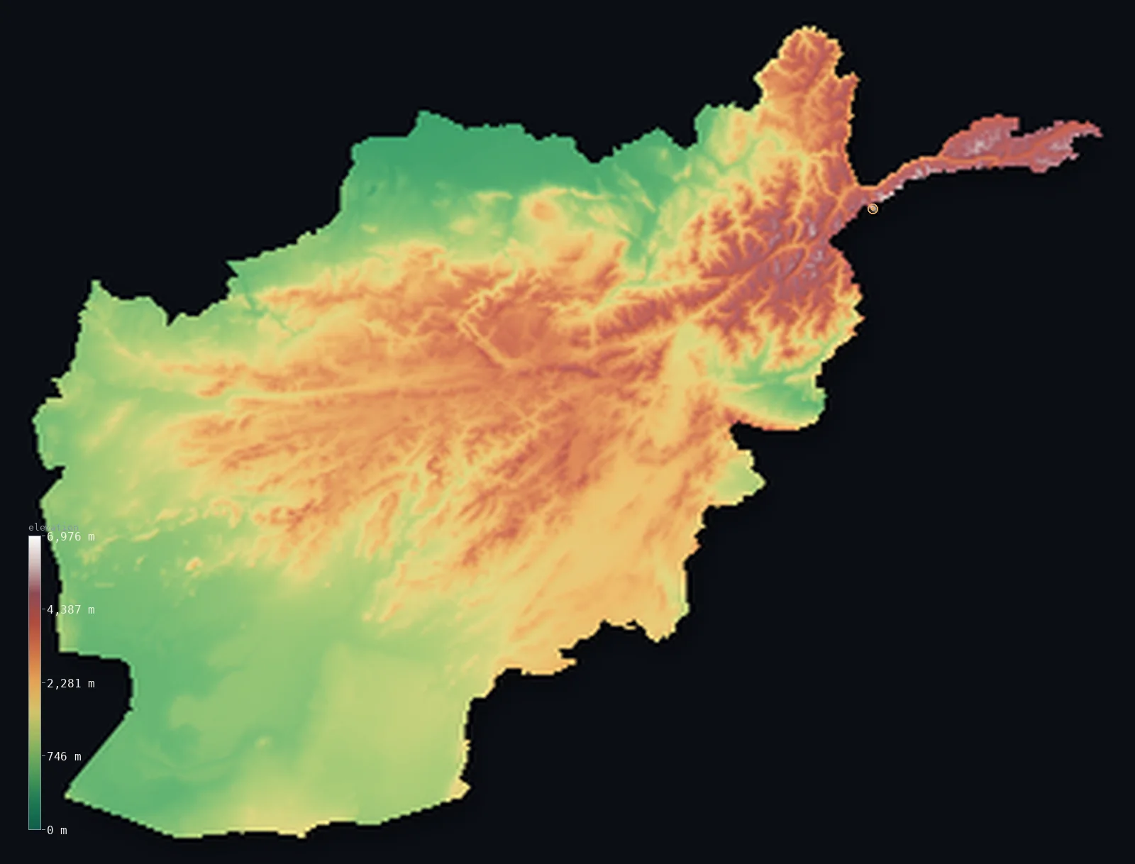
Afghanistan’s highest point is Noshaq at 24,580 ft (7,492 m); its lowest is Amu Darya river at 846 ft (258 m); the mean elevation is 5,906 ft (1,800 m).
Afghanistan is a country with no low ground. Every part of it stands above 656 ft (200 m), and about 69% above 3,281 ft (1,000 m) — a high, rugged interior built around the Hindu Kush, the great mountain range that runs from the northeast toward the centre. In the far northeast, in the narrow Wakhan Corridor, the mountains reach their peak at Noshaq, 24,580 ft (7,492 m), on the border with Pakistan. From there the land steps down — never to the sea, which Afghanistan does not touch, but to the deserts and river plains of the south and west.
- Highest point📚
- 24,580 ft7,492 m
- Afghanistan's highest point is Noshaq at 24,580 ft (7,492 m), in the Hindu Kush at the far end of the Wakhan Corridor on the border with Pakistan — the highest of the country's peaks above 7,000 m and the second-highest of the entire Hindu Kush range, a glaciated summit in the remotest corner of the country.
- Lowest point📚
- 846 ft258 m
- Afghanistan's lowest point is the Amu Darya river in the far north, at about 846 ft (258 m) — and even that is high: Afghanistan is landlocked and elevated throughout, with no coast and no ground near sea level anywhere within its borders.
- Mean elevation⚙
- 5,906 ft1,800 m
- Computed from the GLO-30 model, Afghanistan's mean elevation is 5,906 ft (1,800 m) — a high average that reflects a genuinely high country: this is not a plain with mountains but a rugged, elevated land where even the low points sit hundreds of metres up.
- Median elevation⚙
- 5,177 ft1,578 m
- Half of Afghanistan lies above 5,177 ft (1,578 m) — a strikingly high median, meaning the typical point in the country is already mountain country. The Hindu Kush and its ranges dominate; the plains are the exception, not the rule.
- Elevation range📚
- 23,734 ft7,234 m
- From the Amu Darya to the summit of Noshaq, Afghanistan spans about 23,730 ft — an enormous range, but one that begins high: even the lowest ground is well above sea level, and the climb to the Hindu Kush starts from an already-elevated base.
- Above 1,000 m (3,281 ft)⚙
- 69%
- About 69% of Afghanistan rises above 1,000 m (3,281 ft) — the great majority of the country, since the Hindu Kush and the central highlands cover most of it. Only the southern deserts and the northern and western plains fall below that line.
- Above 2,000 m (6,562 ft)⚙
- 41%
- Roughly 41% of Afghanistan stands above 2,000 m (6,562 ft) — more than two-fifths of the country, the high central spine of the Hindu Kush and the Hazarajat highlands, cold mountain country cut by deep valleys.
- Official area📚
- 251,827 mi²652,230 km²
- Afghanistan covers about 252,000 sq mi (652,230 sq km) — a landlocked country at the meeting of Central and South Asia, its terrain dominated by the Hindu Kush reaching southwest from the Pamir Knot toward the interior.
- Forest cover📚
- 1.9%
- About 1.9% of Afghanistan is forested — a small share, concentrated in the eastern mountains toward Pakistan, where monsoon moisture reaches the slopes; the rest is high steppe, rock, and desert.
Highest and lowest points
Afghanistan's highest point is Noshaq, 24,580 ft (7,492 m), in the Hindu Kush at the eastern tip of the Wakhan Corridor on the border with Pakistan — the highest of the country's peaks above 7,000 m and the second-highest summit of the Hindu Kush after Tirich Mir, which lies just across the border. It is a glaciated, serious mountain in one of the most isolated places on Earth, the thin finger of Afghan territory that reaches east between Tajikistan and Pakistan to touch China. The summit is shared with Pakistan.
source ↗Afghanistan's lowest point is the Amu Darya river along the northern border, at about 846 ft (258 m) — remarkable mainly for how high it is. Afghanistan is landlocked and elevated across its whole extent: there is no coast, no sea-level ground, and even this, the lowest point in the country, sits higher than the summits of some entire nations. From the river the land rises steadily south and east into the Hindu Kush.
source ↗Afghanistan at a glance
Noshaq (7,492 m), on the Pakistan border, is Afghanistan's highest peak and the second-highest summit of the entire Hindu Kush range.
source ↗Every part of Afghanistan stands above 200 m, and about 69% above 1,000 m — it is a high, elevated country with no low ground at all.
source ↗The Wakhan Corridor, a narrow finger of Afghan land in the far northeast, reaches between Tajikistan and Pakistan to touch China — a strip created as a buffer between empires in the 19th century.
source ↗The Hindu Kush runs southwest across Afghanistan from the Pamir Knot, dividing the country and carrying nearly all its highest ground.
source ↗The Hazarajat, the central highlands, is a region of high mountain valleys and plateaus in the heart of the country, above the passes of the Hindu Kush.
source ↗Afghanistan is landlocked, and its lowest point — the Amu Darya at about 258 m — is higher than the highest point of many other countries.
source ↗The Hindu Kush packs roughly two dozen peaks above 7,000 m into a stretch of about 160 km in the far northeast — one of the densest clusters of high mountains outside the Himalaya and Karakoram.
source ↗Most of Afghanistan's rivers never reach the sea: except for the Kabul River, they drain into inland lakes or vanish into the desert sands.
source ↗
Elevation profile of Afghanistan
The largest share of land, 25%, falls in the 500–1,000 m band, and 93% of the territory lies above 500 m (1,640 ft).
- below 500 m (1,640 ft)7%
- 500–1,000 m25%
- 1,000–2,000 m28%
- above 2,000 m (6,562 ft)41%
Highest peaks of Afghanistan
| Peak | Elevation | Range | Note |
|---|---|---|---|
| Noshaq↗ | 24,580 ft7,492 m | Hindu Kush | Highest point of Afghanistan, on the Pakistan border; the westernmost 7,000 m peak on Earth. |
| Saraghrar↗ | 24,111 ft7,349 m | Hindu Kush | A massive 7,000 m massif of the high Hindu Kush near the Pakistan border. |
| Shachaur (Shakhawr)↗ | 23,346 ft7,116 m | Hindu Kush | A second 7,000 m Hindu Kush peak on the Afghanistan–Pakistan border in the far northeast. |
| Kohe Bandaka↗ | 22,451 ft6,843 m | Hindu Kush | A high glaciated peak of the central Hindu Kush, west of the main 7,000 m cluster. |
| Shah Foladi↗ | 16,870 ft5,142 m | Koh-i-Baba (Central Highlands) | Highest peak of the Koh-i-Baba range west of Kabul — the high backbone of the Central Highlands. |
| Sikaram↗ | 15,620 ft4,761 m | Spin Ghar (Safed Koh) | Highest peak of the Spin Ghar range on the southeastern border, above the Tora Bora area. |
The Hindu Kush, the highlands, and the plains below
The Hindu Kush
The mountain range that defines the country, running southwest from the Pamir Knot in the northeast toward the interior. It carries Noshaq and all of Afghanistan's highest ground, splits the country's drainage, and is crossed by high passes — the Salang, the Khyber approaches — that have carried armies and caravans for millennia.
The central highlands (Hazarajat)
The high heart of the country, a region of mountain plateaus and deep valleys west and south of the main Hindu Kush crest, mostly above 2,000 m. Cold, rugged, and remote, it is the source of many of Afghanistan's rivers.
The northern plains
Along the northern border, descending toward the Amu Darya and the plains of Central Asia, lies Afghanistan's lowest and most fertile ground — the loess and steppe of the north, watered by rivers off the mountains, where much of the country's agriculture sits.
The southern and western deserts
Southwest of the mountains the land falls into desert — the sandy Registan and the Dasht-e Margo — dry basins drained by the Helmand river, hot and sparsely peopled, a very different Afghanistan from the cold highlands to the north and east.
How to read this map
Color shows elevation; the raised relief shows real terrain. On this map Afghanistan reads as high, broken country — a mass of brown and white mountains sweeping from the northeast, deepest and highest in the Hindu Kush and the Wakhan finger, stepping down to paler plains in the north and desert in the southwest.
The 3D relief is the actual GLO-30 elevation data, exaggerated vertically so the ranges and valleys show; the ×N relief slider controls how much. Tap anywhere to read that point's exact elevation.
City elevations in Afghanistan
Afghanistan's cities sit in the valleys and on the plains between the mountains — Kabul high in an eastern valley, Kandahar in the south, Herat in the west, Mazar-i-Sharif on the northern plains. All are ringed by high ground.
| City | Population | Elevation |
|---|---|---|
| Kabulcapitalthe capital, in a high valley of the eastern mountains, one of the highest capital cities in the world ↗ | 4,434,550 | 5,909 ft1,801 m |
| Herātin the western valleys near the Iranian border ↗ | 574,300 | 3,041 ft927 m |
| Mazār-e Sharīfon the northern plains toward the Amu Darya ↗ | 523,300 | 1,191 ft363 m |
| Kandahārin the southern lowlands toward the desert ↗ | 523,300 | 3,320 ft1,012 m |
| Jalālābād | 271,900 | 1,896 ft578 m |
| Kunduz | 161,902 | 1,335 ft407 m |
| Ghazni | 141,000 | 7,146 ft2,178 m |
| Khōst | 96,123 | 3,878 ft1,182 m |
| Maymana | 75,900 | 2,838 ft865 m |
| Bāzār-e Yakāwlang | 65,000 | 8,478 ft2,584 m |
Elevation sampled at each city centre from the Copernicus GLO-30 model. Cities and population from GeoNames (CC-BY 4.0).
Afghanistan in comparison
Afghanistan's terrain rises 23,734 ft (7,234 m) from Amu Darya river (846 ft (258 m)) to Noshaq — about 82% of the height of Mount Everest, the world's highest point at 29,032 ft (8,849 m).
- Tajikistan's mean elevation is 9,688 ft — 3,783 ft higher; its high point, Ismoil Somoni Peak, reaches 24,590 ft (7,495 m), 10 ft above. Tajikistan elevation map →
- Nepal's mean elevation is 6,929 ft — 1,024 ft higher; its high point, Mount Everest (Sagarmatha), reaches 29,032 ft (8,849 m), 4,452 ft above. Nepal elevation map →
- Armenia's mean elevation is 6,070 ft — 164 ft higher; its high point, Mount Aragats, reaches 13,419 ft (4,090 m), 11,161 ft below. Armenia elevation map →
Frequently asked questions
What is the highest point in Afghanistan?
- Noshaq, 24,580 ft (7,492 m), in the Hindu Kush on the Pakistan border — the highest of the country's several 7,000-metre peaks, at the far end of the Wakhan Corridor.
What is the lowest point in Afghanistan?
- The Amu Darya river in the far north, at about 846 ft (258 m) — and even that is high, since Afghanistan is landlocked with no ground near sea level.
What is the average elevation of Afghanistan?
- Computed from the Copernicus GLO-30 model, the area-weighted mean is 5,906 ft (1,800 m) — a high figure, because the Hindu Kush and central highlands make almost the whole country mountainous.
Is Afghanistan mountainous?
- Overwhelmingly — about 69% stands above 1,000 m and more than two-fifths above 2,000 m, and the median elevation is over 1,500 m. The Hindu Kush dominates the country.
What is the Wakhan Corridor?
- A narrow strip of Afghan territory in the far northeast, reaching east between Tajikistan and Pakistan to touch China — created as a buffer between the Russian and British empires in the 19th century. Noshaq, the country's high point, stands at its edge.
Is this a topographic, relief, contour, or elevation map of Afghanistan?
- They describe the same thing — terrain height. This page renders the country's actual elevation surface in interactive 3D and reports the statistics computed from it.
About this map
The terrain is rendered from the Copernicus GLO-30 digital elevation model (ESA), masked to the AFG-ADM0 boundary from geoBoundaries (gbOpen). Elevation statistics are computed directly from the model; peak names and researched facts are sourced and cited. See the methodology for the full pipeline.
Our area-weighted mean, computed from the Copernicus GLO-30 model, is 5,906 ft (1,800 m); the figure commonly cited elsewhere is 6,181 ft (1,884 m) (CIA World Factbook). Mountains cover roughly 80% of Afghanistan, dominated by the Hindu Kush and the Central Highlands, so the mean is high despite the northern plains and southwestern deserts; the page reports the area-weighted figure computed from the Copernicus GLO-30 model.
Surveyed national figures: official area · forest cover · high point.
Rendered from Copernicus GLO-30 (ESA, 2021 release), boundaries from geoBoundaries. Generated 2026-06-22.
Bordering countries · 7
Afghanistan shares a land border with these countries — open any one to compare its terrain and highest point.