India Elevation Map — Topographic & 3D Terrain
Explore the terrain of India in interactive 3D, built from Copernicus GLO-30 satellite elevation data — the Himalayan wall, the great northern plain, and the raised Deccan plateau. Drag to rotate, scroll to zoom, and tap any point to read its elevation.
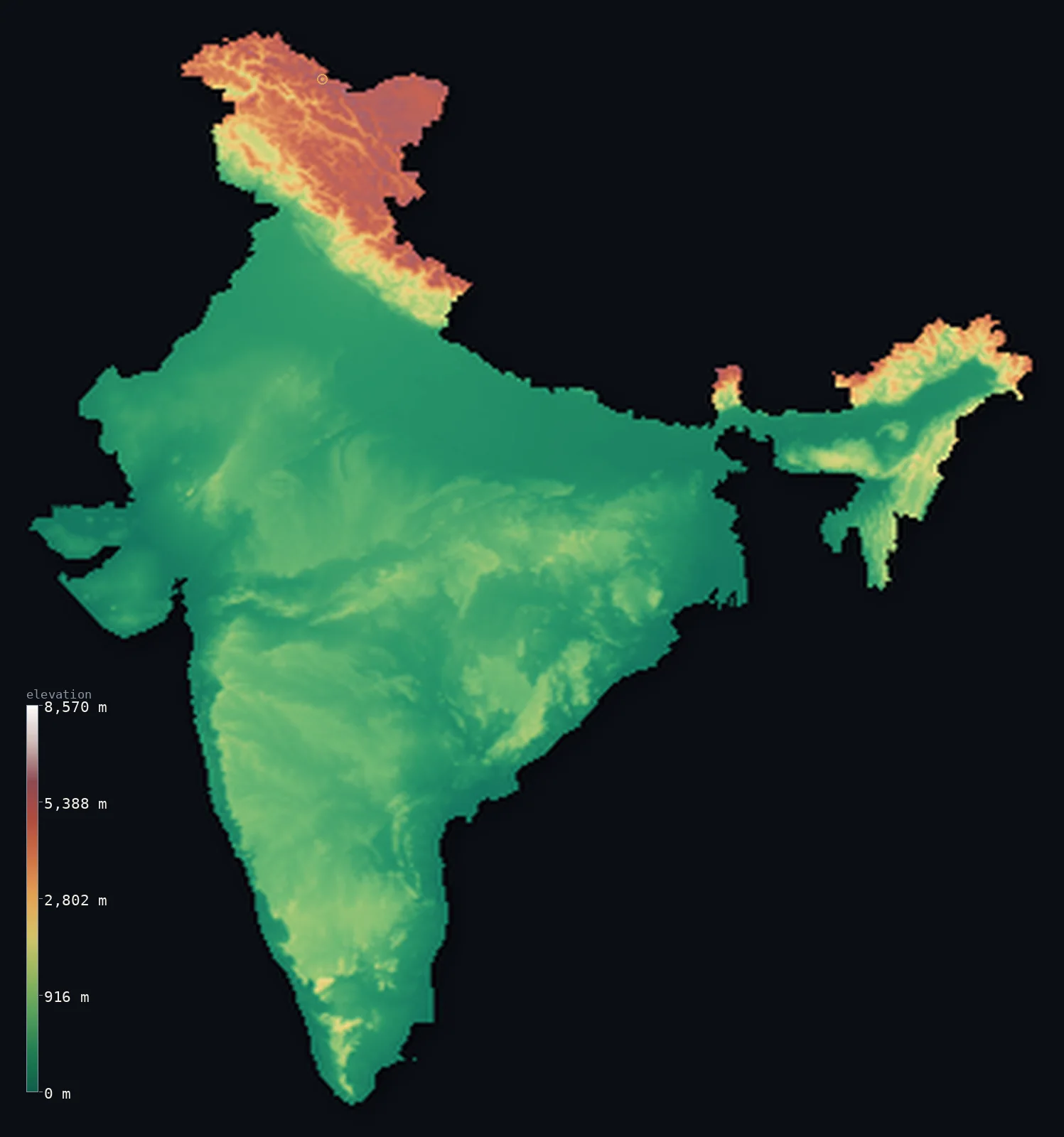
India’s highest point is K2 (Godwin-Austen) at 28,251 ft (8,611 m); its lowest is Indian Ocean at 0 ft (0 m); the mean elevation is 2,306 ft (703 m).
India is a low country with the world's highest mountains along its rim. About 69% of it lies below 500 m (1,640 ft) — the vast Indo-Gangetic plain across the north, and the older, gently raised Deccan plateau that fills the peninsula. Only along the northern border does the land climb into the Himalaya and Karakoram, where the mapped territory reaches 28,251 ft (8,611 m) at K2.
- Highest point📚
- 28,251 ft8,611 m
- Within the boundary this map follows, India's highest point is K2 (Godwin-Austen) at 28,251 ft (8,611 m), the second-highest mountain on Earth. K2 lies in the Kashmir region — territory India claims but which is administered by Pakistan; the highest peak in undisputed Indian territory is Kangchenjunga, at 28,169 ft (8,586 m) on the border with Nepal in Sikkim.
- Lowest point📚
- 0 ft0 m
- India's lowest point is its coastline at sea level — a shoreline of more than 7,000 km along the Arabian Sea, the Bay of Bengal, and the Indian Ocean, where the peninsula's plateau and the delta plains meet the water.
- Mean elevation⚙
- 2,306 ft703 m
- India's mean elevation computed from the GLO-30 model is 2,306 ft (703 m) — a moderate figure that hides two very different Indias: an enormous area of low plain and plateau, and a narrow northern fringe of the highest mountains in the world.
- Median elevation⚙
- 1,017 ft310 m
- Half of India lies below 1,017 ft (310 m) — well under the mean, and the clearest measure of the country's true shape: the Himalaya are spectacular but narrow, while the low plains and the moderate Deccan make up the overwhelming bulk of the land.
- Elevation range📚
- 28,251 ft8,611 m
- From sea level to K2 within the mapped boundary, India spans over 28,000 ft — nearly the full height range of the planet, though almost all of that climb is compressed into the northern mountain rim.
- Above 1,000 m (3,281 ft)⚙
- 13%
- Only about 13% of India rises above 1,000 m (3,281 ft) — the Himalayan and Karakoram north, the Western Ghats along the southwest coast, and the higher edges of the Deccan plateau.
- Above 2,000 m (6,562 ft)⚙
- 9%
- About 9% of India stands above 2,000 m (6,562 ft), essentially all of it in the northern mountains — a small fraction of the country holding some of the greatest heights on Earth.
- Official area📚
- 1,269,219 mi²3,287,263 km²
- India covers about 1.27 million sq mi (3.29 million sq km) — the seventh-largest country on Earth, spanning tropical coast, the world's most populous river plain, and a share of the Himalaya.
- Forest cover📚
- 24.3%
- About 24% of India is forested — concentrated in the Western Ghats, the northeastern hills, and the central highlands, while the densely farmed Indo-Gangetic plain has been almost entirely cleared.
Highest and lowest points
On the boundary this map follows — the geoBoundaries outline, which traces India's claimed borders including the Kashmir region it claims but does not fully control — the highest point within the territory is K2 (Godwin-Austen), 28,251 ft (8,611 m), the second-highest mountain on Earth. K2 lies in an area administered by Pakistan, so the highest peak in undisputed Indian territory is instead Kangchenjunga, 28,169 ft (8,586 m), on the border with Nepal in Sikkim. This map follows the geoBoundaries outline and reports the figures without taking a position on the dispute.
source ↗India's lowest point is sea level, along a coastline running more than 7,000 km. Two of the most striking stretches are the Sundarbans in the east — the world's largest mangrove delta, where the Ganges and Brahmaputra meet the Bay of Bengal in a maze of low islands — and the flat Rann of Kutch in the west, a vast salt marsh that floods each monsoon and dries to a white crust.
source ↗India at a glance
Within the claimed boundary this map follows, India's highest point is K2 (8,611 m); the highest peak in undisputed Indian territory is Kangchenjunga (8,586 m) in Sikkim.
source ↗About 69% of India lies below 500 m - the Himalaya form a narrow northern rim above an enormous expanse of plain and plateau.
source ↗The Indo-Gangetic plain, built from Himalayan sediment, is one of the most fertile and densely populated regions on Earth.
source ↗The Deccan plateau that fills peninsular India is an ancient raised block of volcanic rock, tilted so its rivers run east to the Bay of Bengal.
source ↗The Western Ghats rise sharply along India's southwest coast, catching the monsoon and creating one of the world's biodiversity hotspots.
source ↗The Sundarbans, where the Ganges and Brahmaputra reach the sea, form the largest mangrove forest on Earth.
source ↗
Elevation profile of India
The largest share of land, 69%, falls in the 0–500 m band, and 69% of the territory lies below 500 m (1,640 ft).
- below 500 m (1,640 ft)69%
- 500–1,000 m18%
- 1,000–2,000 m3%
- above 2,000 m (6,562 ft)9%
Highest peaks of India
| Peak | Elevation | Range | Note |
|---|---|---|---|
| K2 (Godwin-Austen)↗ | 28,251 ft8,611 m | Karakoram | World's second-highest mountain; the highest point within the geoBoundaries India outline, in Pakistan-administered Kashmir. |
| Kangchenjunga↗ | 28,169 ft8,586 m | Himalayas | The third-highest mountain on Earth and the highest peak in undisputed Indian territory, in Sikkim on the Nepalese border. |
| Nanda Devi↗ | 25,643 ft7,816 m | Garhwal Himalaya | The highest mountain lying entirely within India, in Uttarakhand. |
| Kamet↗ | 25,446 ft7,756 m | Garhwal Himalaya | A high Himalayan peak of Uttarakhand near the Tibetan border. |
| Anamudi↗ | 8,842 ft2,695 m | Western Ghats | The highest peak of the Western Ghats and of peninsular (southern) India, in Kerala. |
The three Indias
The northern mountains
Along the whole northern border rise the Himalaya and, in the far northwest, the Karakoram — the highest mountain systems on Earth, holding every one of India's great peaks. They are a narrow band of the country's area but its entire high ground, and the source of the rivers that built the plain below.
The Indo-Gangetic plain
Below the mountains stretches the Indo-Gangetic plain, a flat expanse of sediment carried down by the Ganges, Indus, and Brahmaputra. Barely above sea level for hundreds of kilometres, it is among the most fertile and most densely populated land in the world.
The Deccan plateau and the coasts
The peninsula is filled by the Deccan, an ancient raised plateau of volcanic rock edged by the Western and Eastern Ghats. It sits a few hundred metres up, tilted eastward, with narrow coastal plains between the Ghats and the sea.
How to read this map
Color shows elevation; the raised relief shows real terrain. On this map India reads as a green plain across the north below a white Himalayan wall, with the browns of the raised Deccan filling the peninsula.
The 3D relief is the actual GLO-30 elevation data, exaggerated vertically so the plain, the plateau, and the mountain rim all show; the ×N relief slider controls how much. Tap anywhere to read that point's exact elevation.
City elevations in India
India's cities sit mostly low - Mumbai and Chennai on the coasts at sea level, Delhi on the northern plain a little above it. The exception is Bengaluru, up on the Deccan plateau at nearly 3,000 ft, which gives the city its famously mild climate.
| City | Population | Elevation |
|---|---|---|
| Mumbaion the Arabian Sea coast at sea level, below the Western Ghats ↗ | 12,691,836 | 26 ft8 m |
| Delhi | 11,034,555 | 748 ft228 m |
| Bengaluruhigh on the Deccan plateau at about 910 m, which moderates its tropical climate ↗ | 8,495,492 | 2,992 ft912 m |
| Hyderabad | 6,993,262 | 1,686 ft514 m |
| Ahmedabad | 6,357,693 | 180 ft55 m |
| Chennai | 4,681,087 | 52 ft16 m |
| Kolkata | 4,631,392 | 36 ft11 m |
| Surat | 4,591,246 | 69 ft21 m |
| Jaipur | 3,046,163 | 1,430 ft436 m |
| New Delhicapitalthe capital, on the Indo-Gangetic plain near the Yamuna, at about 220 m ↗ | 317,797 | 715 ft218 m |
Elevation sampled at each city centre from the Copernicus GLO-30 model. Cities and population from GeoNames (CC-BY 4.0).
India in comparison
India's terrain rises 28,251 ft (8,611 m) from sea level to K2 (Godwin-Austen) — about 97% of the height of Mount Everest, the world's highest point at 29,032 ft (8,849 m).
- Pakistan's mean elevation is 3,294 ft — 988 ft higher; its high point, K2 (Mount Godwin-Austen), reaches 28,251 ft (8,611 m), 0 ft above. Pakistan elevation map →
- China's mean elevation is 6,014 ft — 3,707 ft higher; its high point, Mount Everest (Qomolangma), reaches 29,032 ft (8,849 m), 781 ft above. China elevation map →
- Nepal's mean elevation is 6,929 ft — 4,623 ft higher; its high point, Mount Everest (Sagarmatha), reaches 29,032 ft (8,849 m), 781 ft above. Nepal elevation map →
Frequently asked questions
What is the highest point in India?
- Within the boundary this map follows, the highest point is K2 (Godwin-Austen), 28,251 ft (8,611 m), in the Kashmir region - an area administered by Pakistan. The highest peak in undisputed Indian territory is Kangchenjunga, 28,169 ft (8,586 m), in Sikkim on the Nepal border.
What is the lowest point in India?
- Sea level, along a coastline of more than 7,000 km on the Arabian Sea, the Bay of Bengal, and the Indian Ocean.
What is the average elevation of India?
- Computed from the Copernicus GLO-30 model, the area-weighted mean is 2,306 ft (703 m) - moderate, because a narrow band of Himalaya sits above an enormous area of low plain and plateau.
How much of India is mountainous?
- Only about 13% rises above 1,000 m, almost all of it along the northern Himalayan rim and the Western Ghats - roughly 69% of the country lies below 500 m.
What is the Deccan plateau?
- An ancient raised block of volcanic rock filling peninsular India, edged by the Western and Eastern Ghats and tilted so its rivers flow east to the Bay of Bengal.
Is this a topographic, relief, contour, or elevation map of India?
- They describe the same thing - terrain height. This page renders the country's actual elevation surface in interactive 3D and reports the statistics computed from it.
About this map
The terrain is rendered from the Copernicus GLO-30 digital elevation model (ESA), masked to the IND-ADM0 boundary from geoBoundaries (gbOpen). Elevation statistics are computed directly from the model; peak names and researched facts are sourced and cited. See the methodology for the full pipeline.
This map renders 3,262,752 km² across 225 landmasses of India. 254 smaller outlying parts — 7,339 km² in total — lie beyond the area shown here. Area statistics above count the full territory.
Because India covers 3,262,752 km², its 3D terrain surface is rendered at roughly 1.7 km per pixel rather than the model’s native 30 m — the full-resolution grid exceeds the render budget for an area this large. The high point and every elevation figure on this page are still measured at native 30 m resolution; only the rendered surface detail is coarsened.
Our area-weighted mean, computed from the Copernicus GLO-30 model, is 2,306 ft (703 m); the figure commonly cited elsewhere is 2,037 ft (621 m) (CIA World Factbook). India spans the towering Himalayas in the north, the broad Indo-Gangetic plains, and the raised Deccan Plateau of the peninsula, giving a moderate mean; the page reports the area-weighted figure computed from the Copernicus GLO-30 model, shown at reduced surface resolution for a country this large.
Surveyed national figures: official area · forest cover · high point.
Rendered from Copernicus GLO-30 (ESA, 2021 release), boundaries from geoBoundaries. Generated 2026-07-12.
Bordering countries · 7
India shares a land border with these countries — open any one to compare its terrain and highest point.