Myanmar Elevation Map — Topographic & 3D Terrain
Explore the terrain of Myanmar in interactive 3D, built from Copernicus GLO-30 satellite elevation data — a great river corridor between mountain arcs, from the tropics to the edge of the Himalaya. Drag to rotate, scroll to zoom, and tap any point to read its elevation.
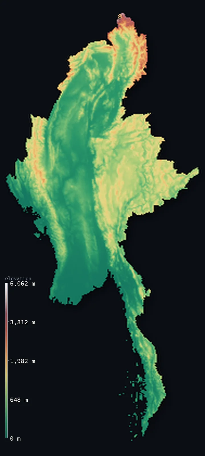
Myanmar’s highest point is Hkakabo Razi at 19,295 ft (5,881 m); its lowest is Andaman Sea / Bay of Bengal at 0 ft (0 m); the mean elevation is 1,909 ft (582 m).
Myanmar is a river between mountains. The Irrawaddy runs down the centre of the country from north to south, its broad valley and delta holding most of the population, while mountain ranges wall it on both sides — the Arakan mountains along the west coast, the Shan plateau to the east, and, in the far north, the ranges rise toward the eastern end of the Himalaya. There the land reaches Hkakabo Razi, claimed at 19,295 ft (5,881 m) — generally held to be the highest point in Southeast Asia.
- Highest point📚
- 19,295 ft5,881 m
- Myanmar's highest point is Hkakabo Razi, in the far north where Myanmar meets China and India — usually given as 19,295 ft (5,881 m) and long considered the highest mountain in Southeast Asia, though a 2013 GPS survey measured the nearby Gamlang Razi at 5,870 m and argued it may be higher, and the exact elevation remains disputed. Either way, it is a remote, glaciated Himalayan summit at the country's northern tip.
- Lowest point📚
- 0 ft0 m
- Myanmar's lowest point is the sea at sea level, along the coasts of the Bay of Bengal and the Andaman Sea — including the wide, low delta where the Irrawaddy reaches the sea in the south.
- Mean elevation⚙
- 1,909 ft582 m
- Computed from the GLO-30 model, Myanmar's mean elevation is 1,909 ft (582 m) — a moderate figure that reflects the country's structure: a broad central lowland along the Irrawaddy, framed by mountain ranges on the west, east, and north that carry the height.
- Median elevation⚙
- 1,175 ft358 m
- Half of Myanmar lies below 1,175 ft (358 m) — below the mean, the mark of a country whose heart is the low Irrawaddy corridor, with the mountains that rim it, though high, covering less of the land than the central plain and its surrounding hills.
- Elevation range📚
- 19,295 ft5,881 m
- From the sea to the summit of Hkakabo Razi, Myanmar spans about 19,300 ft — from tropical delta and coast to a glaciated peak at the edge of the Himalaya, most of the height gained in the far north where the mountain arcs converge.
- Above 1,000 m (3,281 ft)⚙
- 21%
- About 21% of Myanmar rises above 1,000 m (3,281 ft) — the Arakan mountains along the west, the Shan plateau in the east, and the high ranges of the north. The central Irrawaddy lowland between them is far lower.
- Above 2,000 m (6,562 ft)⚙
- 3%
- Roughly 3% of Myanmar stands above 2,000 m (6,562 ft) — the higher Shan plateau, the crest of the Arakan range, and the northern mountains that climb toward Hkakabo Razi.
- Official area📚
- 261,228 mi²676,578 km²
- Myanmar covers about 261,000 sq mi (676,578 sq km) — the largest country in mainland Southeast Asia, built around the Irrawaddy river, framed by mountains on three sides and open to the sea in the south.
- Forest cover📚
- 42.9%
- About 42.9% of Myanmar is forested — extensively, from the tropical forests of the Arakan coast and the Tenasserim in the south to the temperate woodland of the Shan plateau and the northern mountains.
Highest and lowest points
Myanmar's highest point is Hkakabo Razi, in the remote far north where the country's borders meet China and India — long held to be the highest mountain in Southeast Asia at about 19,295 ft (5,881 m). Its exact height is uncertain: a 2013 GPS survey measured the nearby Gamlang Razi at 5,870 m and argued it may be higher, and the precise elevation is still debated. Whichever is higher, both are glaciated Himalayan peaks at the southeastern end of the great range, in one of the least accessible corners of Asia — a world away from the tropical delta at the other end of the country.
source ↗Myanmar's lowest point is the sea at sea level, along a long coastline on the Bay of Bengal and the Andaman Sea. The largest low ground is the Irrawaddy delta in the south — a broad, fertile, densely farmed plain of distributaries and paddy where the country's great river reaches the sea, and, like the deltas to its west, low and exposed to the cyclones of the Bay of Bengal. Behind it the Irrawaddy valley runs north into the interior.
source ↗Myanmar at a glance
Hkakabo Razi, in Myanmar's far north, is generally considered the highest mountain in Southeast Asia at about 5,881 m — though a 2013 GPS survey measured the nearby Gamlang Razi at 5,870 m and argued it may be higher.
source ↗The Irrawaddy river runs the length of Myanmar from north to south, its valley and delta forming the country's heartland and holding most of its people.
source ↗Myanmar is framed by mountains on three sides — the Arakan range along the west coast, the Shan plateau to the east, and the high ranges of the north — around the central Irrawaddy lowland.
source ↗The far north of Myanmar reaches the southeastern end of the Himalaya, carrying glaciers and the country's highest peaks where its borders meet China and India.
source ↗The Arakan Mountains along the west coast cut off the monsoon and historically isolated Myanmar's heartland from the Indian subcontinent.
source ↗The Shan plateau, covering much of eastern Myanmar, is a broad upland of hills and valleys rising above the central plain, part of the country's mountainous rim.
source ↗Only one climber, Takashi Ozaki, is confirmed to have reached Hkakabo Razi's summit (in 1996); later expeditions turned back short of the top.
source ↗
Elevation profile of Myanmar
The largest share of land, 57%, falls in the 0–500 m band, and 57% of the territory lies below 500 m (1,640 ft).
- below 500 m (1,640 ft)57%
- 500–1,000 m21%
- 1,000–2,000 m18%
- above 2,000 m (6,562 ft)3%
Highest peaks of Myanmar
| Peak | Elevation | Range | Note |
|---|---|---|---|
| Hkakabo Razi↗ | 19,295 ft5,881 m | Northern mountains (Kachin, China border) | Highest point of Myanmar and traditionally of mainland Southeast Asia, glaciated, on the Tibet border. |
| Gamlang Razi↗ | 19,259 ft5,870 m | Northern mountains (Kachin, Tibet border) | A glaciated granite peak 6.6 km from Hkakabo Razi; a 2013 GPS survey suggested it may be Myanmar's true highest. |
| Mount Saramati↗ | 12,552 ft3,826 m | Naga Hills (northwest, India border) | The highest peak of the Naga Hills, on the border with India's Nagaland. |
| Nat Ma Taung (Mount Victoria)↗ | 10,016 ft3,053 m | Chin Hills (west) | The highest peak of the western Chin Hills, a national park summit. |
| Loi Leng↗ | 8,770 ft2,673 m | Shan Plateau (east) | The highest point of the eastern Shan Plateau. |
The Irrawaddy corridor and its mountain rim
The Irrawaddy valley and delta
The heart of Myanmar — the broad central lowland along the Irrawaddy, from the dry zone of the interior down to the great delta on the Andaman Sea. Fertile and densely settled, it holds most of the population and the main cities, Yangon and Mandalay, and is the country's low, populous core.
The Arakan and western mountains
Along the west coast rise the Arakan Mountains, a forested range that walls the Irrawaddy lowland off from the Bay of Bengal and the Indian subcontinent beyond — a barrier to the monsoon and, historically, to invasion, dropping to a narrow coastal strip.
The Shan plateau (east)
East of the Irrawaddy the land rises to the Shan plateau — a broad upland of hills, valleys, and rivers covering much of eastern Myanmar, continuing into the ranges that run south down the Tenasserim coast toward Thailand and Malaysia.
The northern mountains
In the far north the ranges climb toward the eastern end of the Himalaya, carrying Hkakabo Razi and the country's only glaciers where the borders meet China and India — the highest, remotest, and coldest terrain in Myanmar, a stark contrast to the tropical delta far to the south.
How to read this map
Color shows elevation; the raised relief shows real terrain. On this map Myanmar reads as a green central corridor — the Irrawaddy valley running north to south — walled by brown-and-white mountains on the west (the Arakan), the east (the Shan plateau), and rising highest in the far north, with the low delta opening to the sea in the south.
The 3D relief is the actual GLO-30 elevation data, exaggerated vertically so the river corridor and the mountain rim both show; the ×N relief slider controls how much. Tap anywhere to read that point's exact elevation.
City elevations in Myanmar
Myanmar's cities line the Irrawaddy and the coast — Yangon near the delta in the south, Mandalay on the river in the central dry zone, Nay Pyi Taw the built capital between them — with fewer large towns in the surrounding mountains. Most sit low, in the valley or on the coast.
| City | Population | Elevation |
|---|---|---|
| Yangonthe largest city, near the Irrawaddy delta in the south, the former capital and main port ↗ | 4,477,638 | 82 ft25 m |
| Mandalayon the Irrawaddy in the central dry zone, the last royal capital ↗ | 1,208,099 | 262 ft80 m |
| Nay Pyi Tawcapitalthe purpose-built capital, in the central lowland between Yangon and Mandalay ↗ | 925,000 | 390 ft119 m |
| Mawlamyine | 438,861 | 118 ft36 m |
| Kalemyo | 348,573 | 400 ft122 m |
| Pathein | 237,089 | 26 ft8 m |
| Yawnghwe | 188,083 | 2,917 ft889 m |
| Kyaukpyu | 180,000 | 26 ft8 m |
| Myeik | 173,298 | 69 ft21 m |
| Kēng Tung | 171,620 | 2,264 ft690 m |
Elevation sampled at each city centre from the Copernicus GLO-30 model. Cities and population from GeoNames (CC-BY 4.0).
Myanmar in comparison
Myanmar's terrain rises 19,295 ft (5,881 m) from sea level to Hkakabo Razi — about 66% of the height of Mount Everest, the world's highest point at 29,032 ft (8,849 m).
- Thailand's mean elevation is 932 ft — 978 ft lower; its high point, Doi Inthanon, reaches 8,415 ft (2,565 m), 10,879 ft below. Thailand elevation map →
- Laos's mean elevation is 2,188 ft — 279 ft higher; its high point, Phou Bia, reaches 9,249 ft (2,819 m), 10,046 ft below. Laos elevation map →
- India's mean elevation is 2,306 ft — 397 ft higher; its high point, K2 (Godwin-Austen), reaches 28,251 ft (8,611 m), 8,957 ft above. India elevation map →
Frequently asked questions
What is the highest point in Myanmar?
- Hkakabo Razi, in the far north where Myanmar meets China and India, usually given as 19,295 ft (5,881 m) — long considered the highest in Southeast Asia, though a 2013 GPS survey measured the nearby Gamlang Razi at 5,870 m and argued it may be higher, and the exact height is disputed.
What is the lowest point in Myanmar?
- The sea at sea level, along the Bay of Bengal and Andaman coasts, including the low Irrawaddy delta in the south.
What is the average elevation of Myanmar?
- Computed from the Copernicus GLO-30 model, the area-weighted mean is 1,909 ft (582 m) — moderate, reflecting the low central Irrawaddy corridor framed by mountain ranges on three sides.
Is Hkakabo Razi the highest mountain in Southeast Asia?
- It is usually said to be, at about 5,881 m — but a 2013 GPS survey measured the nearby Gamlang Razi at 5,870 m and argued it may be higher, and the exact elevations remain disputed. Both are in Myanmar's far north.
What is the Irrawaddy?
- Myanmar's great river, running the length of the country from the northern mountains to the Andaman Sea — its valley and delta are the country's heartland and hold most of its people.
Is this a topographic, relief, contour, or elevation map of Myanmar?
- They describe the same thing — terrain height. This page renders the country's actual elevation surface in interactive 3D and reports the statistics computed from it.
About this map
The terrain is rendered from the Copernicus GLO-30 digital elevation model (ESA), masked to the MMR-ADM0 boundary from geoBoundaries (gbOpen). Elevation statistics are computed directly from the model; peak names and researched facts are sourced and cited. See the methodology for the full pipeline.
Our area-weighted mean, computed from the Copernicus GLO-30 model, is 1,909 ft (582 m); no authority publishes a mean elevation (no authoritative published mean). Myanmar is rimmed by mountains - the northern Himalayan edge, the western ranges and the Shan Plateau - around a low central lowland along the Irrawaddy, so elevation varies enormously; the page reports the mean computed from the Copernicus GLO-30 model.
Surveyed national figures: official area · forest cover · high point.
Rendered from Copernicus GLO-30 (ESA, 2021 release), boundaries from geoBoundaries. Generated 2026-06-25.
Bordering countries · 5
Myanmar shares a land border with these countries — open any one to compare its terrain and highest point.