Thailand Elevation Map — Topographic & 3D Terrain
Explore the terrain of Thailand in interactive 3D, built from Copernicus GLO-30 satellite elevation data — a broad central plain with hills to the north and a long peninsula to the south. Drag to rotate, scroll to zoom, and tap any point to read its elevation.
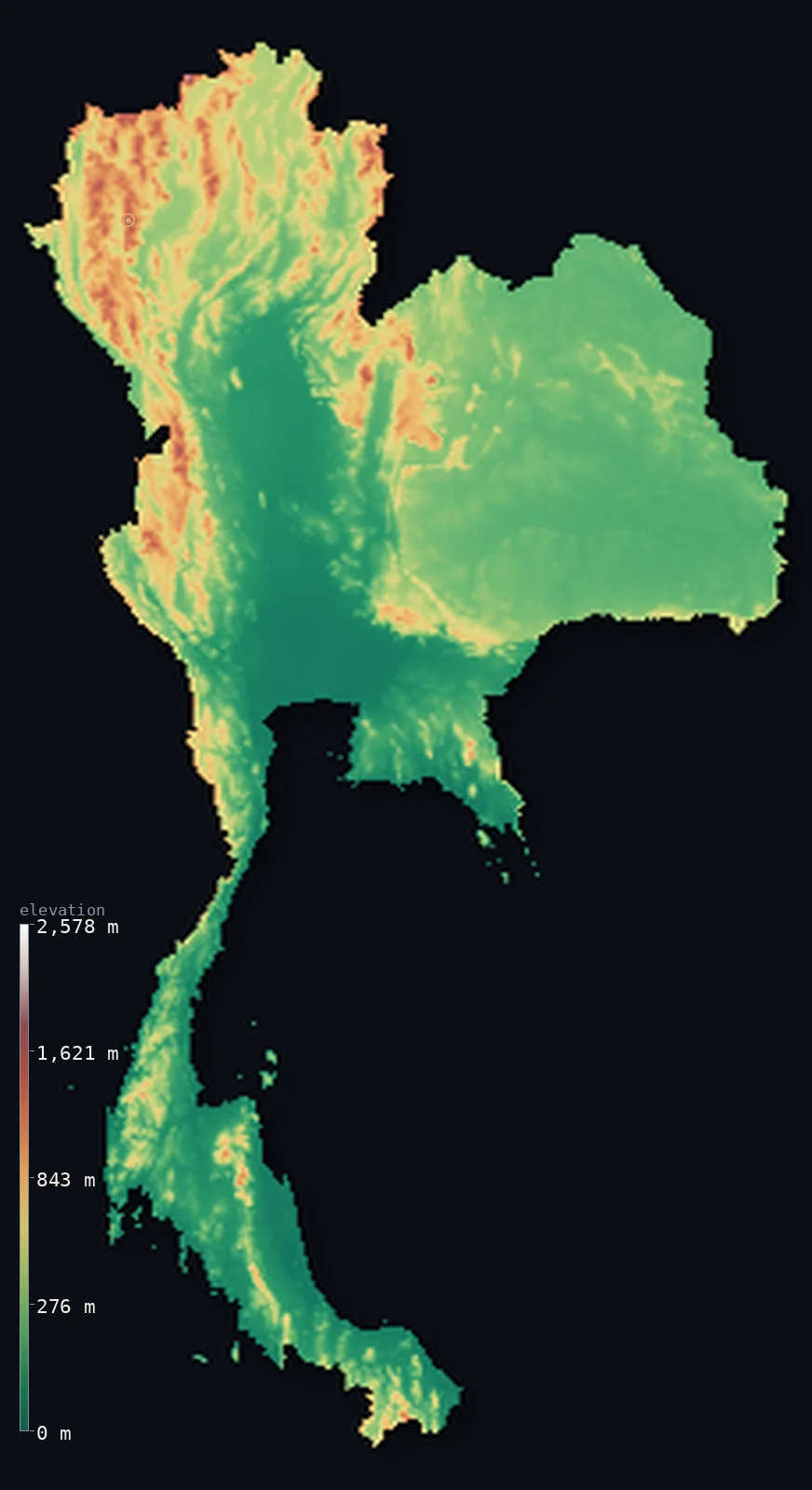
Thailand’s highest point is Doi Inthanon at 8,415 ft (2,565 m); its lowest is Gulf of Thailand at 0 ft (0 m); the mean elevation is 932 ft (284 m).
Thailand is built around a plain. The Chao Phraya lowland fills the country's centre — flat, river-fed, and the site of Bangkok and most of the population — while the land rises into forested hills in the north and narrows southward into a long peninsular tail. It is a low country overall: half of it lies below 584 ft (178 m), and only about 3.5% climbs past 3,281 ft (1,000 m), all of that in the northern ranges around Doi Inthanon at 8,415 ft (2,565 m).
- Highest point📚
- 8,415 ft2,565 m
- Thailand's highest point is Doi Inthanon at 8,415 ft (2,565 m), in the northern hills near Chiang Mai — the country's only genuinely cool high ground, forested to the summit and occasionally frost-touched in winter.
- Lowest point📚
- 0 ft0 m
- Thailand's lowest point is the sea, on coasts facing both the Gulf of Thailand and the Andaman Sea — and the central plain behind them lies so low and flat that Bangkok itself sits barely above the tide.
- Mean elevation⚙
- 932 ft284 m
- Thailand's mean elevation computed from the GLO-30 model is 932 ft (284 m) — low, and accurate to the country's structure: the central plain and the peninsula are close to sea level, and the only real height is in the northern quarter.
- Median elevation⚙
- 584 ft178 m
- Half of Thailand lies below 584 ft (178 m) — a low median that reflects how much of the country is plain and coast, with the northern hills too small a share to lift the middle very far.
- Elevation range📚
- 8,415 ft2,565 m
- From the sea to Doi Inthanon, Thailand spans about 8,400 ft — modest for a country of this size, because outside the northern ranges the land almost never rises far.
- Above 1,000 m (3,281 ft)⚙
- 3%
- Only about 3% of Thailand rises above 1,000 m (3,281 ft) — a small share, confined to the northern hills where the ranges run down from Myanmar and Laos.
- Official area📚
- 198,117 mi²513,120 km²
- Thailand covers about 198,000 sq mi (513,120 sq km) — a compact heartland around the central plain, with a long arm reaching south down the Malay Peninsula toward the equator.
- Forest cover📚
- 39%
- About 39% of Thailand is forested — densest in the northern hills and along the mountainous western border, sparse across the intensively farmed central plain.
Highest and lowest points
Thailand's highest point is Doi Inthanon, 8,415 ft (2,565 m), in Chiang Mai province — the tallest of the northern hills where ranges descend from the Shan highlands of Myanmar. It is high enough to be genuinely cool: cloud forest covers its upper slopes, and winter mornings at the summit can bring frost, which is unusual enough in Thailand to draw visitors specifically to see it.
source ↗Thailand's lowest point is sea level, on two coasts — the Gulf of Thailand to the east and the Andaman Sea to the west, separated by the narrow spine of the peninsula. The most consequential low ground is the Chao Phraya plain: Bangkok sits on soft delta sediment barely above the tide, and the city has been subsiding as groundwater is drawn from beneath it, which makes even small rises in sea level a serious concern.
source ↗Thailand at a glance
Doi Inthanon, 2,565 m, is Thailand's highest point - cool enough near the summit that winter frost is a local attraction.
source ↗The Chao Phraya plain fills central Thailand - flat, river-fed, and holding Bangkok and a large share of the country's population.
source ↗Only about 3.5% of Thailand rises above 1,000 m, essentially all of it in the northern hills.
source ↗Bangkok sits on soft delta sediment barely above sea level and has been slowly subsiding as groundwater is pumped from beneath it.
source ↗Thailand's southern arm runs down the Malay Peninsula with coasts on two seas - the Gulf of Thailand and the Andaman Sea - separated by a narrow mountainous spine.
source ↗The Khorat Plateau in the northeast is a raised, drier tableland tilted away from the central plain toward the Mekong.
source ↗You can drive all the way to the summit of Thailand's highest mountain on a paved road.
source ↗
Elevation profile of Thailand
The largest share of land, 56%, falls in the 0–200 m band, and 82% of the territory lies below 500 m (1,640 ft).
- below 500 m (1,640 ft)82%
- 500–1,000 m15%
- 1,000–2,000 m3%
- above 2,000 m (6,562 ft)<1%
Highest peaks of Thailand
| Peak | Elevation | Range | Note |
|---|---|---|---|
| Doi Inthanon↗ | 8,415 ft2,565 m | Thanon Thong Chai Range | Highest point of Thailand, the 'roof of Thailand' near Chiang Mai. |
| Doi Pha Hom Pok↗ | 7,497 ft2,285 m | Daen Lao Range | The second-highest mountain in Thailand, on the Myanmar border in Fang District. |
| Doi Luang Chiang Dao↗ | 7,136 ft2,175 m | Daen Lao Range | A dramatic limestone massif north of Chiang Mai, one of the country's highest peaks. |
| Doi Pui↗ | 5,528 ft1,685 m | Suthep-Pui massif | A high peak of the Suthep-Pui range just west of Chiang Mai. |
| Doi Suthep↗ | 5,253 ft1,601 m | Suthep-Pui massif | The temple-topped mountain overlooking Chiang Mai, lower but a famous landmark. |
A plain and its edges
The central plain
The heart of Thailand is the broad, flat lowland of the Chao Phraya river — fertile, rice-growing, and densely populated, with Bangkok at its southern end where the river reaches the Gulf. It is the country's lowest and most important ground.
The northern hills
North of the plain the land breaks into forested ranges running down from Myanmar and Laos, carrying Doi Inthanon and all of Thailand's high terrain. Valleys between the ridges hold Chiang Mai and the northern towns.
The Khorat Plateau (northeast)
The northeast is a raised, sandy tableland tilted gently toward the Mekong — drier than the rest of the country and set apart from the central plain by a low escarpment.
The southern peninsula
Thailand's long southern arm runs down the Malay Peninsula, a narrow strip of limestone hills and forest with the Gulf on one side and the Andaman Sea on the other, fringed by islands and karst towers.
How to read this map
Color shows elevation; the raised relief shows real terrain. On this map Thailand reads as a broad flat green centre with browns gathering in the north, a faint raised plateau to the northeast, and a thin green tail running south.
The 3D relief is the actual GLO-30 elevation data, exaggerated vertically so the low plain and the northern hills both show; the ×N relief slider controls how much. Tap anywhere to read that point's exact elevation.
City elevations in Thailand
Thai cities sit low - Bangkok on the delta barely above the tide, the coastal and peninsular towns at sea level. Only Chiang Mai in the north stands meaningfully higher, in a valley among the hills.
| City | Population | Elevation |
|---|---|---|
| Bangkokcapitalthe capital, on the Chao Phraya delta barely above the tide, and slowly subsiding ↗ | 5,104,476 | 23 ft7 m |
| Vientiane | 840,940 | 574 ft175 m |
| Hat Yai | 191,696 | 36 ft11 m |
| Lampang | 156,139 | 774 ft236 m |
| Kabin Buri | 140,056 | 69 ft21 m |
| Surat Thani | 132,040 | 26 ft8 m |
| Nakhon Ratchasima | 126,391 | 607 ft185 m |
| Hua Hin | 126,355 | 26 ft8 m |
| Ubon Ratchathani | 122,533 | 410 ft125 m |
| Khon Kaen | 114,459 | 545 ft166 m |
Elevation sampled at each city centre from the Copernicus GLO-30 model. Cities and population from GeoNames (CC-BY 4.0).
Thailand in comparison
Thailand's terrain rises 8,415 ft (2,565 m) from sea level to Doi Inthanon — about 29% of the height of Mount Everest, the world's highest point at 29,032 ft (8,849 m).
- Myanmar's mean elevation is 1,909 ft — 978 ft higher; its high point, Hkakabo Razi, reaches 19,295 ft (5,881 m), 10,879 ft above. Myanmar elevation map →
- Laos's mean elevation is 2,188 ft — 1,257 ft higher; its high point, Phou Bia, reaches 9,249 ft (2,819 m), 833 ft above. Laos elevation map →
- Cambodia's mean elevation is 404 ft — 528 ft lower; its high point, Phnom Aural, reaches 5,938 ft (1,810 m), 2,477 ft below. Cambodia elevation map →
Frequently asked questions
What is the highest point in Thailand?
- Doi Inthanon, 8,415 ft (2,565 m), in the northern hills near Chiang Mai - forested to the summit and cool enough for winter frost.
What is the lowest point in Thailand?
- Sea level, on coasts facing both the Gulf of Thailand and the Andaman Sea - and the central plain behind them lies barely above the tide.
What is the average elevation of Thailand?
- Computed from the Copernicus GLO-30 model, the area-weighted mean is 932 ft (284 m) - low, because the central plain and the southern peninsula sit close to sea level.
Is Thailand mountainous?
- Only in the north - about 3.5% of the country rises above 1,000 m, essentially all of it in the hills descending from Myanmar and Laos. The centre is a broad flat plain.
Why is Bangkok at risk from flooding?
- It sits on soft delta sediment barely above sea level, and the ground has been subsiding as groundwater is pumped from beneath the city.
Is this a topographic, relief, contour, or elevation map of Thailand?
- They describe the same thing - terrain height. This page renders the country's actual elevation surface in interactive 3D and reports the statistics computed from it.
About this map
The terrain is rendered from the Copernicus GLO-30 digital elevation model (ESA), masked to the THA-ADM0 boundary from geoBoundaries (gbOpen). Elevation statistics are computed directly from the model; peak names and researched facts are sourced and cited. See the methodology for the full pipeline.
Our area-weighted mean, computed from the Copernicus GLO-30 model, is 932 ft (284 m); the figure commonly cited elsewhere is 942 ft (287 m) (CIA World Factbook). Thailand is mostly low - the great central Chao Phraya plain, the coasts and the long southern peninsula sit near sea level, with high ground confined to the northern highlands and scattered ranges - so its mean elevation is low; the page reports the area-weighted figure computed from the Copernicus GLO-30 model.
Surveyed national figures: official area · forest cover · high point.
Rendered from Copernicus GLO-30 (ESA, 2021 release), boundaries from geoBoundaries. Generated 2026-07-07.
Bordering countries · 4
Thailand shares a land border with these countries — open any one to compare its terrain and highest point.