Cambodia Elevation Map — Topographic & 3D Terrain
Explore the terrain of Cambodia in interactive 3D, built from Copernicus GLO-30 satellite elevation data — a low central plain around the Tonlé Sap, rimmed by mountains and plateaus. Drag to rotate, scroll to zoom, and tap any point to read its elevation.
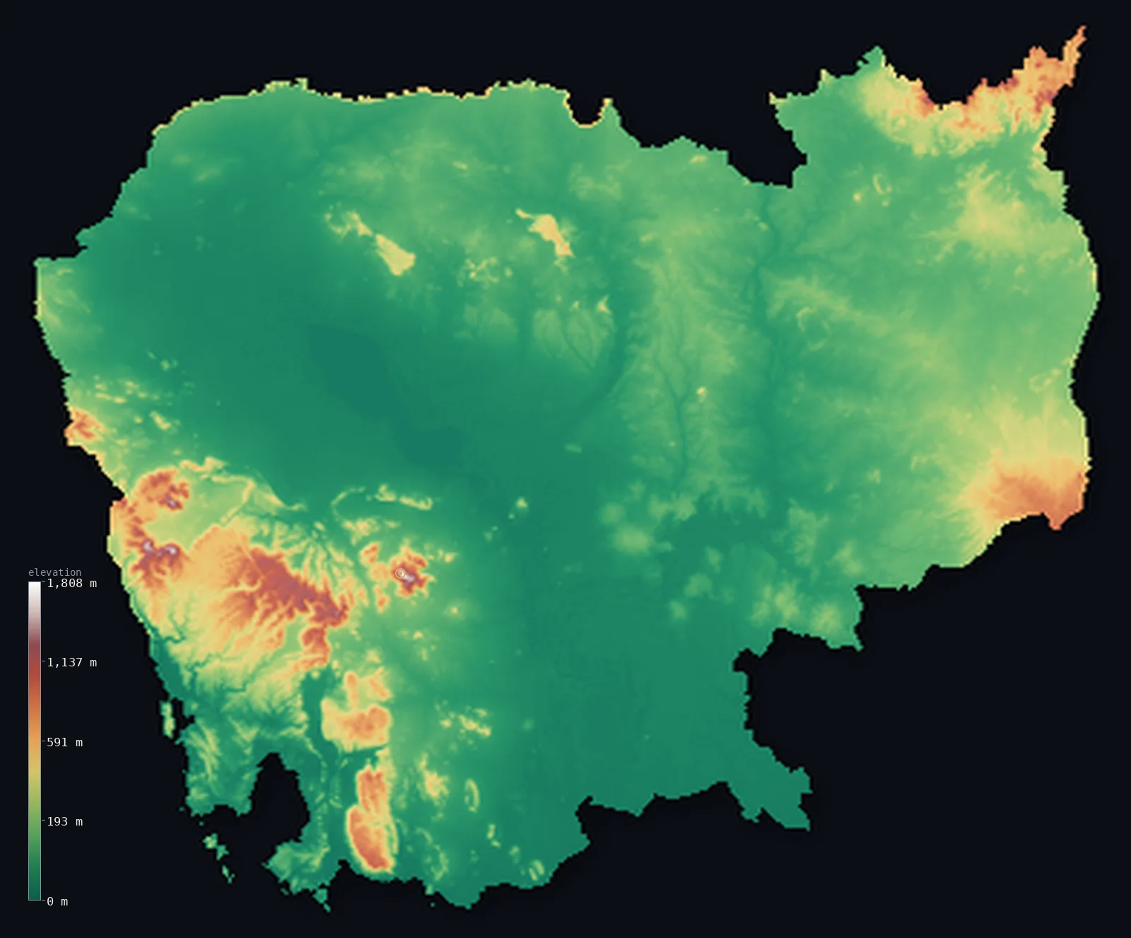
Cambodia’s highest point is Phnom Aural at 5,938 ft (1,810 m); its lowest is Gulf of Thailand at 0 ft (0 m); the mean elevation is 404 ft (123 m).
Cambodia is mostly a low, flat central plain. At its heart lies the Tonlé Sap — the 'Great Lake,' the largest freshwater lake in Southeast Asia — and the broad lowland basin of the Mekong and its tributaries, a flat expanse of rice fields and floodplain covering the centre of the country. Around this plain the land rises to a rim of mountains and plateaus: the Cardamom and Elephant Mountains in the southwest, holding the high point Phnom Aural at 5,938 ft (1,810 m), the Dâmrei ranges, and the Dângrêk escarpment along the northern border with Thailand.
- Highest point📚
- 5,938 ft1,810 m
- Cambodia's highest point is Phnom Aural at 5,938 ft (1,810 m), in the Cardamom Mountains of the southwest — the highest summit of the forested upland rim that encircles Cambodia's central plain. It rises from the Cardamom range, the most rugged and heavily forested part of the country, well above the low basin at its heart.
- Lowest point📚
- 0 ft0 m
- Cambodia's lowest point is the sea at sea level, along the short coast on the Gulf of Thailand in the southwest — though the country's defining low ground is inland: the vast, flat basin of the Tonlé Sap and the Mekong, only a few metres above the sea across much of its expanse.
- Mean elevation⚙
- 404 ft123 m
- Computed from the GLO-30 model, Cambodia's mean elevation is 404 ft (123 m) — low, reflecting a country that is mostly a flat central plain: the broad lowland of the Tonlé Sap and the Mekong covers the middle, with higher ground only around the mountainous rim, and only about 15% of the country rising even above 200 m.
- Median elevation⚙
- 223 ft68 m
- Half of Cambodia lies below about 223 ft (68 m) — a low figure that captures the country's form: the flat central plain of the Tonlé Sap and the Mekong covers so much of Cambodia that most of the land lies only a little above the sea, with the mountain rim a small minority of the area.
- Elevation range📚
- 5,938 ft1,810 m
- Almost all of Cambodia's relief sits in the mountainous rim: the vast central plain barely rises above the sea, while the Cardamoms in the southwest climb to Phnom Aural at 5,938 ft (1,810 m) — so the country's whole vertical span, plain to peak, belongs to its edge, not its low heart.
- Above 1,000 m (3,281 ft)⚙
- 1%
- Only about 1% of Cambodia rises above 1,000 m (3,281 ft) — a mere sliver, the highest peaks of the Cardamoms in the southwest. Almost the whole country is the low central plain and the lower ground of its encircling rim, all of it well below that line.
- Official area📚
- 69,898 mi²181,035 km²
- Cambodia covers about 69,900 sq mi (181,035 sq km) — a country in mainland Southeast Asia, mostly a low central plain around the Tonlé Sap lake and the Mekong, rimmed by mountains and plateaus, with a short coast on the Gulf of Thailand.
- Forest cover📚
- 45%
- About 45% of Cambodia is forested — much of it on the mountainous rim, above all the dense forests of the Cardamom Mountains, one of the largest remaining wildernesses in Southeast Asia; the central plain is intensively farmed, mostly for rice.
Highest and lowest points
Cambodia's highest point is Phnom Aural, 5,938 ft (1,810 m), in the Cardamom Mountains of the southwest. It is the highest summit of the forested rim of mountains and plateaus that encircles Cambodia's low central plain — the Cardamom and Elephant Mountains here in the southwest being the most rugged and heavily forested. Phnom Aural rises well above the flat basin of the Tonlé Sap and the Mekong at the country's heart, the roof of a country that is otherwise mostly low plain.
source ↗Cambodia's lowest point is the sea at sea level, along its short coast on the Gulf of Thailand in the southwest. But the country's essential low ground is inland: the great central plain of the Tonlé Sap and the Mekong, a broad, flat basin only a few metres above the sea, covering much of Cambodia. The Tonlé Sap lake at its heart is remarkable — each monsoon the Mekong's floodwaters reverse the flow of the Tonlé Sap River and swell the lake several times over, flooding the surrounding plain, before draining back in the dry season. This pulse of the Great Lake shapes the low heart of the country.
source ↗Cambodia at a glance
Cambodia is shaped like a bowl: a vast low central plain — the Mekong and Tonlé Sap basin, about three-quarters of the country and mostly under 100 m — ringed by mountains on the north, southwest and south.
source ↗The Tonlé Sap is one of the only rivers on Earth that reverses direction twice a year — the monsoon Mekong pushes water back up into the Great Lake, which swells severalfold before draining again in the dry season.
source ↗At flood stage the Tonlé Sap lake grows from about 2,600 km² to as much as 10,000–13,000 km², making it the largest freshwater lake in Southeast Asia and one of the world's richest inland fisheries.
source ↗Cambodia's mountains are modest — Phnom Aural, the highest, is only about 1,810 m, and most of the country barely rises above sea level.
source ↗The western slopes of the Cardamom Mountains are among the wettest places in Southeast Asia, catching 3,000–5,000 mm of monsoon rain a year and holding vast tracts of intact rainforest.
source ↗The ruins of Angkor, the relic of the ancient Khmer civilisation, stand in the forests just north of the Tonlé Sap lake.
source ↗At Phnom Penh four water courses meet at a single point called the Chattomukh, the 'Four Faces' — the Mekong (above and below), the Bassac and the Tonlé Sap River.
source ↗
Elevation profile of Cambodia
The largest share of land, 85%, falls in the 0–200 m band, and 95% of the territory lies below 500 m (1,640 ft).
- below 500 m (1,640 ft)95%
- 500–1,000 m5%
- 1,000–2,000 m1%
Highest peaks of Cambodia
| Peak | Elevation | Range | Note |
|---|---|---|---|
| Phnom Aural↗ | 5,938 ft1,810 m | Cardamom Mountains (eastern) | Highest point of Cambodia, in the Cardamom Mountains of the southwest, in a wildlife sanctuary. |
| Cardamom Mountains main ridge↗ | 4,921 ft1,500 m | Cardamom Mountains | The forested northwest–southeast spine of the Cardamoms, rising above 1,500 m, one of Southeast Asia's largest remaining wild forests. |
| Elephant Mountains (Bokor area)↗ | 3,527 ft1,075 m | Elephant Mountains (Dâmrei) | A southern extension of the Cardamoms toward the coast, rising to around 900–1,000 m, with Bokor and its rainforest plateau. |
| Northeastern highlands (Ratanakiri/Mondulkiri)↗ | 2,625 ft800 m | Annamite foothills / eastern plateaus | The dissected basalt plateaus of the northeast (Ratanakiri, Mondulkiri) merging into Vietnam's Central Highlands. |
| Dângrêk escarpment high point↗ | 2,461 ft750 m | Dângrêk Mountains | The highest ground of the Dângrêk escarpment along the Thai border — a steep south-facing cliff forming the northern rim of the Tonlé Sap basin. |
Cambodia: the central plain, the Cardamoms, and the uplands
The central plain (the Tonlé Sap and Mekong basin)
The heart of Cambodia is a broad, low, flat plain — the basin of the Tonlé Sap lake and the Mekong River and its tributaries, a vast expanse of rice fields and floodplain only a few metres above the sea. Covering most of the country and holding most of its people, the flood-watered lowland is the essential Cambodia.
The southwestern mountains (the Cardamoms)
In the southwest rise the Cardamom and Elephant Mountains — Cambodia's most rugged and heavily forested highlands, holding Phnom Aural, the country's high point, and falling away to the short coast on the Gulf of Thailand. One of the region's largest forest wildernesses.
The northern and eastern uplands
Around the rest of the plain rise lower uplands — the Dângrêk escarpment along the northern border with Thailand, a long wall above the lowland, and the plateaus and hills of the east toward Vietnam and Laos. The plain's raised rim, drier and more thinly settled than the centre.
How to read this map
Color shows elevation; the raised relief shows real terrain. On this map Cambodia reads as a low central bowl — a broad flat expanse of low green filling the middle, the basin of the Tonlé Sap and the Mekong, ringed by the higher browns of the mountainous rim: the Cardamoms in the southwest, the Dângrêk escarpment along the north, the eastern uplands.
The 3D relief is the actual GLO-30 elevation data, exaggerated vertically so the low plain and the encircling mountains both show; the ×N relief slider controls how much. Tap anywhere to read that point's exact elevation.
City elevations in Cambodia
Cambodia's cities sit on the low central plain — Phnom Penh, the capital, where the Tonlé Sap River meets the Mekong; Siem Reap by the Great Lake near Angkor; Battambang in the northwest; Kampong Cham on the Mekong. Nearly all lie in the low basin; only Sihanoukville sits on the coast.
| City | Population | Elevation |
|---|---|---|
| Phnom Penhcapitalthe capital, where the Tonlé Sap River meets the Mekong (the Chattomukh) ↗ | 1,573,544 | 62 ft19 m |
| Takeoon the low southern plain ↗ | 843,931 | 30 ft9 m |
| Siem Reapby the Tonlé Sap lake, near the ruins of Angkor ↗ | 139,458 | 66 ft20 m |
| Battambangin the northwestern plain ↗ | 119,251 | 62 ft19 m |
| Paoy Paeton the northwestern Thai border ↗ | 98,934 | 144 ft44 m |
| Kampong Chhnangon the Tonlé Sap, on the central plain ↗ | 75,244 | 59 ft18 m |
| Sihanoukvillethe main port, on the Gulf of Thailand coast — the lowest ↗ | 73,036 | 23 ft7 m |
| Preaek Prasabon the Mekong in the east ↗ | 64,466 | 79 ft24 m |
| Kampong Chamon the Mekong east of Phnom Penh ↗ | 61,750 | 66 ft20 m |
| Anlong Veaengin the north, below the Dângrêk escarpment ↗ | 56,927 | 177 ft54 m |
Elevation sampled at each city centre from the Copernicus GLO-30 model. Cities and population from GeoNames (CC-BY 4.0).
Cambodia in comparison
Cambodia's terrain rises 5,938 ft (1,810 m) from sea level to Phnom Aural — about 20% of the height of Mount Everest, the world's highest point at 29,032 ft (8,849 m).
- Vietnam's mean elevation is 1,273 ft — 869 ft higher; its high point, Fansipan (Phan Xi Pang), reaches 10,325 ft (3,147 m), 4,386 ft above. Vietnam elevation map →
- Thailand's mean elevation is 932 ft — 528 ft higher; its high point, Doi Inthanon, reaches 8,415 ft (2,565 m), 2,477 ft above. Thailand elevation map →
- Laos's mean elevation is 2,188 ft — 1,785 ft higher; its high point, Phou Bia, reaches 9,249 ft (2,819 m), 3,310 ft above. Laos elevation map →
Frequently asked questions
What is the highest point in Cambodia?
- Phnom Aural, 5,938 ft (1,810 m), in the Cardamom Mountains of the southwest — the highest of the forested rim that encircles the central plain.
What is the lowest point in Cambodia?
- The sea at sea level on the Gulf of Thailand coast — though the country's defining low ground is inland, the vast flat basin of the Tonlé Sap and the Mekong.
What is the average elevation of Cambodia?
- Computed from the Copernicus GLO-30 model, the area-weighted mean is 404 ft (123 m) — low, because Cambodia is mostly a flat central plain, with higher ground only around the mountainous rim.
What is the Tonlé Sap?
- The largest freshwater lake in Southeast Asia, at the heart of Cambodia's central plain — each monsoon the Mekong's floodwaters reverse the flow of its outlet river and swell the lake several times over, flooding the surrounding lowland.
Is Cambodia flat?
- Mostly — the broad central plain of the Tonlé Sap and the Mekong, low and flat, covers much of the country, with mountains only around the rim: the Cardamoms in the southwest and the Dângrêk in the north. The highest point is Phnom Aural, 1,810 m.
Is this a topographic, relief, contour, or elevation map of Cambodia?
- They describe the same thing — terrain height. This page renders the country's actual elevation surface in interactive 3D and reports the statistics computed from it.
About this map
The terrain is rendered from the Copernicus GLO-30 digital elevation model (ESA), masked to the KHM-ADM0 boundary from geoBoundaries (gbOpen). Elevation statistics are computed directly from the model; peak names and researched facts are sourced and cited. See the methodology for the full pipeline.
Our area-weighted mean, computed from the Copernicus GLO-30 model, is 404 ft (123 m); the figure commonly cited elsewhere is 413 ft (126 m) (CIA World Factbook). Cambodia is mostly a low, flat central plain — the basin of the Tonlé Sap and the Mekong, only a few metres above the sea — with higher ground confined to the mountainous rim, so its area-weighted mean is low. The figure computed here from the Copernicus GLO-30 model, about 123 m, is essentially the 126 m cited by the CIA World Factbook.
Surveyed national figures: official area · forest cover · high point.
Rendered from Copernicus GLO-30 (ESA, 2021 release), boundaries from geoBoundaries. Generated 2026-06-22.
Bordering countries · 3
Cambodia shares a land border with these countries — open any one to compare its terrain and highest point.